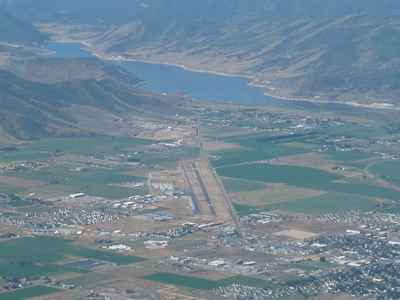
| HEBER CITY MUNI - MCDONALD HEBER UT |
| |
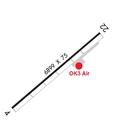
| Lat: N 4028.9 Long: W 11125.7 Elev: 5637 Var: -11 Longest Runway: 6899 | ||
| AWOS: 124.82 CTAF: 122.8 | ||
| |||||||||||||||||||||||||||||||||||||||||||||||||||||||||||||||||||||
| |||||||||||||||||||||||||||||||||||||||||||||||||||||||||||||||||||||
| |||||||||||||||||||||||||||||||||||||||||||||||||||||||||||||||||||||
| Rwy | Rwy | |||||||
| 6899x75 | 6899' | 6899x75 | 6899' | |||||
| Runway ID | Single Wheel | Double Wheel | Double Tandem Wheel | Dual Double Wheel |
| These numbers are Advisory and are not limits. The Airport Manager should have more accurate Weight Limits | ||||
| FltPlan does not have IFR approaches charts available for K36U. |
 Airport Diagram might not be current. | |
| Facility Name: | HEBER CITY MUNI - RUSS MCDONALD FIELD |
| City Name: | HEBER |
| County: | WASATCH |
| State abbrev: | UT |
| State Name: | UTAH |
| Ownership: | PUBLICLY OWNED |
| Use: | OPEN TO THE PUBLIC |
| Owner's Name: | HEBER CITY |
| Address: | 75 N. MAIN STREET |
| HEBER, UT 84032 | |
| Owner's Phone: | 435-654-0757 |
| Manager's Name: | DENIS GODFREY |
| Address: | 75 NORTH MAIN STREET |
| HEBER, UT 84032 | |
| Phone: | 435-654-4854 |
| FAA Region: | NORTHWEST MOUNTAIN |
| FAA Field Office: | DEN |
| Date | Sunrise | Sunset |
|---|---|---|
| 10/11/17 Wednesday | 7:32 | 18:52 |
| 10/12/17 Thursday | 7:33 | 18:50 |
| 10/13/17 Friday | 7:34 | 18:49 |
| 10/14/17 Saturday | 7:35 | 18:47 |
| 10/15/17 Sunday | 7:36 | 18:46 |
| 10/16/17 Monday | 7:38 | 18:44 |
| 10/17/17 Tuesday | 7:39 | 18:43 |
| 10/18/17 Wednesday | 7:40 | 18:41 |
| 10/19/17 Thursday | 7:41 | 18:40 |
| 10/20/17 Friday | 7:42 | 18:39 |
| 10/21/17 Saturday | 7:43 | 18:37 |
| 10/22/17 Sunday | 7:44 | 18:36 |
| 10/23/17 Monday | 7:45 | 18:34 |
| 10/24/17 Tuesday | 7:46 | 18:33 |
| Airport Attendance Schedule | MAY-OCT 7 Days A Week 0700-1830, NOV-APR 7 Days A Week 0800-1700 |
| Airport Status | OPERATIONAL (This Status can change at any time - please check NOTAMS) |
| Airport Lighting Schedule | ACTVT MIRL RY 04/22 & PAPI RY 22 - CTAF. |
| Airport Storage Available | Tie Downs, Hanger |
| Extra Services Available | Glider, Flight Instruction, Aircraft Rental, Aircraft Sales, Glider Towing |
| Wind Indicator | YES - (lighted) |
| Control Tower | NO |
| CTAF Frequency | 122.800 |
| Unicom Frequency | 122.800 |
| Rotating Beacon Color | CLEAR-GREEN (Light Land Airport) |
| Segmented Circle | YES |
| Landing Fee | YES; TRANSIENT LANDING FEE FOR ACFTT OVER 8,000 LBS. |
| Airport Inspected | STATE - performed by STATE AERONAUTICAL PERSONNEL |
| Inspection Date | 10/07/2015 |
| Type of Fuel Available | Grade 100LL, JET A (freeze point -40C)UL94 |
| Airframe Repair Service | MAJOR |
| Power Plant Repair Service | MAJOR |
| Latitude | N4028.9 |
| Longitude | W11125.7 (ESTIMATED) |
| Arpt Elevation | 5636ft (SURVEYED) |
| Magnetic Variation | 11E |
| 1 miles S | of HEBER |
| Traffic Pattern Altitude | |
| Sectional Chart | SALT LAKE CITY |
| Operations (Reported) | Yearly | Avg. Daily |
|---|---|---|
| General Aviation Transient | 11104 | 30 |
| General Aviation Local | 6814 | 19 |
| Air Taxi | 1550 | 4 |
| Commerical | 0 | 0 |
| Commuter | 0 | 0 |
| Military | 0 | 0 |
| Aircraft based on Field | |
|---|---|
| General Aviation Singles | 67 |
| General Aviation Multi | 4 |
| Jet Aircraft | 6 |
| General Aviation Helicopters | 3 |
| Military Aircraft | 0 |
| Gliders | 16 |
| Ultralights | 0 |
| FSS on field | NO |
| FSS tie-in | CEDAR CITY |
| FSS Phone | 1-800-WX-BRIEF |
| Who issues Notams | CDC |
| Notam D service at airport | YES |
| ARTCC Name | SALT LAKE CITY |
| Airport Certification | |
| Aircraft Rescue & Firefighting Index | None |
| Airport of Entry | No |
| Custom Landing Rights | No |
| Joint Civil/Military | No |
| Military Landing rights | YES |
| NATIONAL PLAN OF INTEGRATED AIRPORT SYSTEMS (NPIAS) |
| GRANT AGREEMENTS UNDER FAAP/ADAP/AIP |
| ASSURANCES PURSUANT TO TITLE VI, CIVIL RIGHTS ACT OF 1964 |
| ACFT DEPARTING SOUTH-SOUTHWESTBOUND BE AWARE OF HIGH TFC VOLUME DESCENDING TO 16,000 FT OVER SPANE INTERSECTION. |
| GLIDER ACTIVITY ON AND INVOF ARPT. |
| BALLOON ACTIVITY ON AND INVOF ARPT IN SUMMER MONTHS DURING MORNING HRS. |
| SNOW REMOVAL DAYLIGHT HRS ONLY DURING WINTER MONTHS. |
| Runway: 04 | Runway: 22 | ||
| Mag heading: | 39° | Mag heading: | 219° |
| Rwy Slope: | .78% Up | Rwy Slope: | -.78% Down |
| Approach: | Approach: | ||
| Pattern: | Left Traffic | Pattern: | Left Traffic |
| Markings: | PRECISION INSTRUMENT | Markings: | NONPRECISION INSTRUMENT |
| Marking Condition: | GOOD | Marking Condition: | GOOD |
| Arresting Dev: | Arresting Dev: | ||
| Lat & Long: | N4028.5 W11126.3 | Lat. & Long.: | N4029.3 W11125.2 |
| Elev: | 5582.7 ft. MSL | Elev: | 5636.7 ft. MSL |
| TCH: | TCH: | 46 ft. AGL | |
| Visual Glide Path: | Visual Glide Path: | 4.00 degrees | |
| Displaced Threshold: | No | Displaced Threshold: | No |
| Touchdown Zone: | YES | Touchdown Zone: | YES |
| Touchdown Elev.: | 5608.2 feet | Touchdown Elev.: | 5636.7 feet |
| Visual Glide Slope: | Visual Glide Slope: | 4-Light PAPI on LEFT side of Runway; RY 22 PAPI UNUSBL BYD 3.5 NM FM THLD & 6 DEGS FM CNTRLN. | |
| RVR Equipment: | RVR Equipment: | ||
| RVV Equipment: | NO | RVV Equipment: | NO |
| Approach Lights: | Approach Lights: | ||
| REIL: | NO | REIL: | NO |
| Centerline Lights: | NO | Centerline Lights: | NO |
| Touchdown lights: | NO | Touchdown lights: | NO |
| Runway Category: | Runway with a Non-precision Approach having visibility minimums greater than 3/4 mile | Runway Category: | Runway with a Non-precision Approach having visibility minimums greater than 3/4 mile |
| Declared Distances: | Declared Distances: | ||
| Obstructions: | Obstructions: | POLE | |
| Marked: | Marked: | NOT Marked/Lighted | |
| Clearance slope: | 34:1 | Clearance slope: | 30:1 |
| Obstruction height: | Obstruction height: | 33 feet AGL | |
| Dist. from runway: | Dist. from runway: | 1220 feet | |
| Centerline offset: | Centerline offset: | 177 feet left of centerline | |
| Comments: | Comments: |
Thanks for using FltPlan.com
all rights reserved © 1999-2017 by Flight Plan LLC