| NORTHAMPTON NORTHAMPTON MA |
| |
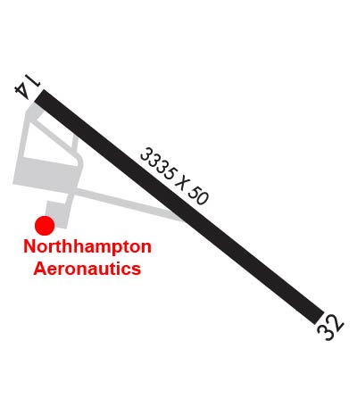
| Lat: N 4219.7 Long: W 07236.7 Elev: 121 Var: +15 Longest Runway: 3335 | ||
| Clr Del: 133.6 CTAF: 122.7 | ||
| |||||||||||||||||||||||||||||||||||||||||||||||||||||||||||||
| |||||||||||||||||||||||||||||||||||||||||||||||||||||||||||||
| Rwy | Rwy | |||||||
| 3335x50 | 3335' | 3335x50 | 3115' | |||||
| Runway ID | Single Wheel | Double Wheel | Double Tandem Wheel | Dual Double Wheel |
| 14/32 | 7,500 | N/A | N/A | N/A |
| These numbers are Advisory and are not limits. The Airport Manager should have more accurate Weight Limits | ||||
 Airport Diagram might not be current. | |
| Facility Name: | NORTHAMPTON |
| City Name: | NORTHAMPTON |
| County: | HAMPSHIRE |
| State abbrev: | MA |
| State Name: | MASSACHUSETTS |
| Ownership: | PRIVATELY OWNED |
| Use: | OPEN TO THE PUBLIC |
| Owner's Name: | SEVEN BRAVO TWO, LLC |
| Address: | 160 OLD FERRY RD |
| NORTHAMPTON, MA 01060 | |
| Owner's Phone: | 413-568-0905 |
| Manager's Name: | RICHARD MACISAAC |
| Address: | 160 OLD FERRY RD |
| NORTHAMPTON, MA 01060 | |
| Phone: | 860-833-7602; RICHM@FLY7B2.COM |
| FAA Region: | NEW ENGLAND |
| FAA Field Office: | NONE |
| Date | Sunrise | Sunset |
|---|---|---|
| 02/07/25 Friday | 6:58 | 17:12 |
| 02/08/25 Saturday | 6:56 | 17:14 |
| 02/09/25 Sunday | 6:55 | 17:15 |
| 02/10/25 Monday | 6:54 | 17:16 |
| 02/11/25 Tuesday | 6:53 | 17:17 |
| 02/12/25 Wednesday | 6:51 | 17:19 |
| 02/13/25 Thursday | 6:50 | 17:20 |
| 02/14/25 Friday | 6:49 | 17:21 |
| 02/15/25 Saturday | 6:47 | 17:23 |
| 02/16/25 Sunday | 6:46 | 17:24 |
| 02/17/25 Monday | 6:45 | 17:25 |
| 02/18/25 Tuesday | 6:43 | 17:26 |
| 02/19/25 Wednesday | 6:42 | 17:28 |
| 02/20/25 Thursday | 6:40 | 17:29 |
| Airport Attendance Schedule | 7 Days A Week 0800-1800 |
| Airport Status | OPERATIONAL (This Status can change at any time - please check NOTAMS) |
| Airport Lighting Schedule | ACTVT MIRL RWY 14/32 - CTAF. |
| Airport Storage Available | Tie Downs, Hanger |
| Extra Services Available | Flight Instruction, Aircraft Rental |
| Wind Indicator | YES - (lighted) |
| Control Tower | NO |
| CTAF Frequency | 122.700 |
| Unicom Frequency | 122.700 |
| Rotating Beacon Color | WG |
| Segmented Circle | NO |
| Landing Fee | NO |
| Airport Inspected | STATE - performed by STATE AERONAUTICAL PERSONNEL |
| Inspection Date | 12/04/2024 |
| Type of Fuel Available | Grade 100LL; -10FUEL IS 24 HR SELF-SERVE. |
| Airframe Repair Service | MAJOR |
| Power Plant Repair Service | MAJOR |
| Latitude | N4219.7 |
| Longitude | W07236.7 (ESTIMATED) |
| Arpt Elevation | 121ft (SURVEYED) |
| Magnetic Variation | 15W |
| 1 miles NE | of NORTHAMPTON |
| Traffic Pattern Altitude | |
| Sectional Chart | NEW YORK |
| Operations (Reported) | Yearly | Avg. Daily |
|---|---|---|
| General Aviation Transient | 0 | 0 |
| General Aviation Local | 0 | 0 |
| Air Taxi | 0 | 0 |
| Commerical | 0 | 0 |
| Commuter | 0 | 0 |
| Military | 0 | 0 |
| Aircraft based on Field | |
|---|---|
| General Aviation Singles | 0 |
| General Aviation Multi | 0 |
| Jet Aircraft | 0 |
| General Aviation Helicopters | 0 |
| Military Aircraft | 0 |
| Gliders | 0 |
| Ultralights | 0 |
| FSS on field | NO |
| FSS tie-in | BURLINGTON |
| FSS Phone | 1-800-WX-BRIEF |
| Who issues Notams | BTV |
| Notam D service at airport | YES |
| ARTCC Name | BOSTON |
| Airport Certification | |
| Aircraft Rescue & Firefighting Index | None |
| Airport of Entry | No |
| Custom Landing Rights | No |
| Joint Civil/Military | No |
| Military Landing rights | No |
| THIS AIRPORT HAS BEEN SURVEYED BY THE NATIONAL GEODETIC SURVEY. |
| ARPT CLSD TO ALL ACFT & HEL CRTFYD FOR 12500 LBS & OVR. |
| LDG FEE FOR COML ACFT. |
| FEE & PPR FOR COML BLN OPS. |
| FOR CD CTC YANKEE APCH AT 860-386-3597. |
| GLDR ACT ON & INVOF ARPT MAY-OCT. |
| (PAY PHONE) PAY PHONE AVAILABLE. |
Airport Communications & Frequencies:
| ||||||||||||||||
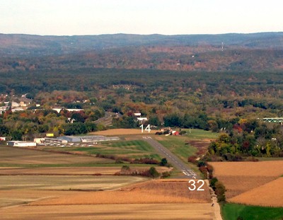
| Runway: 14 | Runway: 32 | ||
| Mag heading: | 143° | Mag heading: | 323° |
| Rwy Slope: | -.08% Down | Rwy Slope: | .08% Up |
| Approach: | Approach: | ||
| Pattern: | Left Traffic | Pattern: | Left Traffic |
| Markings: | BASIC | Markings: | BASIC |
| Marking Condition: | GOOD | Marking Condition: | GOOD |
| Arresting Dev: | Arresting Dev: | ||
| Lat & Long: | N4219.8 W07237.0 | Lat. & Long.: | N4219.5 W07236.4 |
| Elev: | 121.4 ft. MSL | Elev: | 118.8 ft. MSL |
| TCH: | 60 ft. AGL | TCH: | |
| Visual Glide Path: | 4.50 degrees | Visual Glide Path: | |
| Displaced Threshold: | No | Displaced Threshold: | 220 feet |
| Touchdown Zone: | YES | Touchdown Zone: | YES |
| Touchdown Elev.: | 121.4 feet | Touchdown Elev.: | 119.3 feet |
| Visual Glide Slope: | 4-Light PAPI on LEFT side of Runway | Visual Glide Slope: | |
| RVR Equipment: | RVR Equipment: | ||
| RVV Equipment: | NO | RVV Equipment: | NO |
| Approach Lights: | Approach Lights: | ||
| REIL: | NO | REIL: | NO |
| Centerline Lights: | NO | Centerline Lights: | NO |
| Touchdown lights: | NO | Touchdown lights: | NO |
| Runway Category: | Runway with a Visual Approach | Runway Category: | Runway with a Visual Approach |
| Declared Distances: | Declared Distances: | ||
| Obstructions: | TREES | Obstructions: | TREES |
| Marked: | NOT Marked/Lighted | Marked: | NOT Marked/Lighted |
| Clearance slope: | 6:1 | Clearance slope: | 25:1; APCH 38:1 TO DTHR. |
| Obstruction height: | 60 feet AGL | Obstruction height: | 32 feet AGL |
| Dist. from runway: | 600 feet | Dist. from runway: | 1000 feet |
| Centerline offset: | 210 right of centerline | Centerline offset: | 51 feet right of centerline |
| Comments: | 15 FT ROAD IN PRIM SFC. | Comments: | ROAD IN PRIM SFC 50 FT FM THR. |
Thanks for using FltPlan.com
all rights reserved © 1999-2025 by Flight Plan LLC