
| BOEING FIELD/KING COUNTY INTL SEATTLE WA |
| |
| Lat: N 4731.8 Long: W 12218.1 Elev: 22 Var: -15 Longest Runway: 10007 | ||
| Clr Del: 132.4 Dept. ATIS: 127.75 Arr. ATIS: 127.75 Ground: 121.9 Tower: 118.3/120.6 | ||

| |||||||||||||||||||||||||||||||||||||||
| |||||||||||||||||||||||||||||||||||||||
| |||||||||||||||||||||||||||||||||||||||
| |||||||||||||||||||||||||||||||||||||||
| |||||||||||||||||||||||||||||||||||||||
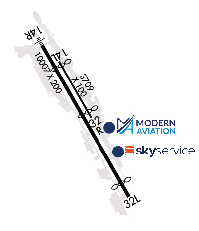
| Rwy | Rwy | |||||||
| 3709x100 | 3459' | 3709x100 | 3334' | |||||
| 10007x200 | 10007' | 110.90 - 135° | 10007x200 | 9120' | 110.90 - 315° | |||
| Runway ID | Single Wheel | Double Wheel | Double Tandem Wheel | Dual Double Wheel |
| 14L/32R | 120,000 | 250,000 | 550,000 | 1,109,000 |
| 14R/32L | 100,000 | 200,000 | 500,000 | 800,000 |
| These numbers are Advisory and are not limits. The Airport Manager should have more accurate Weight Limits | ||||
 Airport Diagram might not be current. | |
| Facility Name: | BOEING FLD/KING COUNTY INTL |
| City Name: | SEATTLE |
| County: | KING |
| State abbrev: | WA |
| State Name: | WASHINGTON |
| Ownership: | PUBLICLY OWNED |
| Use: | OPEN TO THE PUBLIC |
| Owner's Name: | KING COUNTY |
| Address: | 516 THIRD AVE |
| SEATTLE, WA 98104 | |
| Owner's Phone: | (206) 296-7380 |
| Manager's Name: | JOHN PARROTT, AAE; JPARROTT@KINGCOUNTY.GOV. |
| Address: | 7277 PERIMETER ROAD SOUTH |
| SEATTLE, WA 98108-3844 | |
| Phone: | 206-296-7334 |
| FAA Region: | NORTHWEST MOUNTAIN |
| FAA Field Office: | SEA |
| Date | Sunrise | Sunset |
|---|---|---|
| 06/25/26 Thursday | 5:13 | 21:11 |
| 06/26/26 Friday | 5:13 | 21:11 |
| 06/27/26 Saturday | 5:14 | 21:11 |
| 06/28/26 Sunday | 5:14 | 21:11 |
| 06/29/26 Monday | 5:15 | 21:10 |
| 06/30/26 Tuesday | 5:15 | 21:10 |
| 07/01/26 Wednesday | 5:16 | 21:10 |
| 07/02/26 Thursday | 5:16 | 21:10 |
| 07/03/26 Friday | 5:17 | 21:10 |
| 07/04/26 Saturday | 5:18 | 21:09 |
| 07/05/26 Sunday | 5:18 | 21:09 |
| 07/06/26 Monday | 5:19 | 21:08 |
| 07/07/26 Tuesday | 5:20 | 21:08 |
| 07/08/26 Wednesday | 5:21 | 21:07 |
| Airport Attendance Schedule | CONTINUOUS |
| Airport Status | OPERATIONAL (This Status can change at any time - please check NOTAMS) |
| Airport Lighting Schedule | HIRL RWY 14R/32L OPEN DUSK-DAWN. MIRL RWY 14L/32R NOT OPER 0600-1500Z++. |
| Airport Storage Available | Tie Downs, Hanger |
| Extra Services Available | Air Freight, Air Ambulance, Avionics, Cargo Handling, Charter, Flight Instruction, Aircraft Rental, Aircraft Sales, Annual Surveying |
| Wind Indicator | YES - (lighted) |
| Control Tower | YES |
| CTAF Frequency | |
| Unicom Frequency | 122.950 |
| Rotating Beacon Color | WG |
| Segmented Circle | NO |
| Landing Fee | YES |
| Airport Inspected | FEDERAL - performed by FAA AIRPORTS FIELD PERSONNEL |
| Inspection Date | 05/13/2026 |
| Type of Fuel Available | Grade 100LL, JET A (freeze point -40C) |
| Airframe Repair Service | MAJOR |
| Power Plant Repair Service | MAJOR |
| Latitude | N4731.8 |
| Longitude | W12218.1 (ESTIMATED) |
| Arpt Elevation | 21ft (SURVEYED) |
| Magnetic Variation | 15E |
| 4 miles S | of SEATTLE |
| Traffic Pattern Altitude | |
| Sectional Chart | SEATTLE |
| Operations (Reported) | Yearly | Avg. Daily |
|---|---|---|
| General Aviation Transient | 0 | 0 |
| General Aviation Local | 0 | 0 |
| Air Taxi | 0 | 0 |
| Commerical | 0 | 0 |
| Commuter | 0 | 0 |
| Military | 0 | 0 |
| Aircraft based on Field | |
|---|---|
| General Aviation Singles | 0 |
| General Aviation Multi | 0 |
| Jet Aircraft | 0 |
| General Aviation Helicopters | 0 |
| Military Aircraft | 0 |
| Gliders | 0 |
| Ultralights | 0 |
| FSS on field | NO |
| FSS tie-in | SEATTLE |
| FSS Phone | 1-800-WX-BRIEF |
| Who issues Notams | BFI |
| Notam D service at airport | YES |
| ARTCC Name | SEATTLE |
| Airport Certification | |
| Aircraft Rescue & Firefighting Index | AIRPORT HAS A CERTIFICATE UNDER CFR PART 139 |
| Airport of Entry | YES |
| Custom Landing Rights | No |
| Joint Civil/Military | No |
| Military Landing rights | YES |
| NATIONAL PLAN OF INTEGRATED AIRPORT SYSTEMS (NPIAS) |
| GRANT AGREEMENTS UNDER FAAP/ADAP/AIP |
| SURPLUS PROPERTY AGREEMENT UNDER PUBLIC LAW 289 |
| ASSURANCES PURSUANT TO TITLE VI, CIVIL RIGHTS ACT OF 1964 |
| AGREEMENT UNDER DLAND OR DCLA HAS EXPIRED. |
| GA ITNRNT/TSNT PRKG AVBL. CTC ARPT OPS 206-296-7334. |
| TWR 80 FT AGL LCTD 1200 FT N AND 900 FT W OF THLD RY 14R. |
| FOR NOISE ABATEMENT PROCEDURES, CONTACT NOISE OFFICE AT (206) 296-7334. |
| EXTENSIVE HELICOPTER TRAINING ACTIVITY ON TAXIWAY B. |
| FOR MUSEUM OF FLT TSNT ACFT PRKG, PPR, CALL MUSEUM OF FLT SCTY (206) 920-9770. |
| TAXIWAY ZULU AND 880' SPECIAL USE PAVEMENT AVAILABLE 72 HOURS PRIOR PERMISSION REQUIRED. CONTACT AIRPORT OPERATIONS 206-296-7334. |
| TPA RWY 14L/32R 1000 MSL; RWY 14R/32L 800 MSL. |
| EMERG FREQ 121.5 NOT MNT AT TWR. |
| FOR BOEING MILITARY FLIGHT CENTER RAMP PERMISSION, CTC RAMP COORDINATOR 206-225-0989, 72 HOUR PRIOR PERMISSION REQUIRED, 96 HOUR PRIOR PERMISSION REQUIRED IF ORDNANCES/MUNITIONS INSTALLED OR IF ORDNANCES/MUNITIONS STORAGE IS REQUIRED. LIMITED LOX SERVICE MEETING MIL-PRF-27210J, TYPE II AVAILABLE FOR MILITARY FLIGHT CENTER TRANSIENT AIRCRAFT, CONTACT 96 HOURS PRIOR WITH NEEDED VOLUME AND AIRCRAFT TYPE. PRIOR TO ARRIVAL ONTO BOEING COMMERCIAL AIRPLANE RAMP, CTC BOEING SEATTLE AT 123.425 OR CALL 206-662-4500. ADVANCED PERMISSION TO ACCESS BOEING COMMERCIAL AIRPLANE RAMP ONLY, CTC 206-544-5900 M-F 1600Z-0000Z. |
| FOR CD WHEN ATCT IS CLSD CTC SEATTLE APCH AT 206-214-4722. |
| VFR PILOTS SHLD REVIEW & EXPC VFR PROCS PRIOR TO ARR/DEP. |
| TOUCH AND GO LNDGS PROHIBITED 2200-0700. |
| BIRD FLOCKS WITHIN ARPT VICINITY. - CHECK LOCAL ADVISORIES. |
| FLIGHT NOTIFICATION SERVICE (ADCUS) AVBL. |
| 14' ANT (MKD/LGTD) 230' FM RY 14L END 125' R. |
| TWY A1 & TWY A FROM A1-A3 RSTRD TO ACFT UP TO 150000 LBS AND LESS THAN 108 FT WINGSPAN. |
| TWYS A2; A4: A6; &B2 RSTD TO ACFT UP TO 12500 LBS. TWY A9 RSTD TO ACFT UP TO 60000LBS. |
| RWY 14L/ 32RRWY 14L/32R NOT AVBL FOR PART 121/PART 380 OPS WITH SKED PAX CARRYING OPS MORE THAN 9 PAX SEATS AND NON-SKED PAX CARRYING OPS MORE THAN 30 PAX SEATS. |
| RWY 14L/ 32RLTD TO USE BY ACFT UP TO 12,500 LBS. |
| RWY 14L/ 32RPCR VALUE: 310/F/B/X/T |
| RWY 14R/ 32LPCR VALUE: 770/R/C/W/T |
Airport Communications & Frequencies:
| |||||||||||||||||||||||||||||||||||||||||||||||||||||||||||||||||||||||||||||||||||||||||||||||||||||||||||||||||||||||||||||||||||||||||||||||||||
| Runway: 14L | Runway: 32R | ||
| Mag heading: | 135° | Mag heading: | 315° |
| Rwy Slope: | -.01% Down | Rwy Slope: | .01% Up |
| Approach: | Approach: | ||
| Pattern: | Left Traffic | Pattern: | Right Traffic |
| Markings: | BASIC | Markings: | BASIC |
| Marking Condition: | GOOD | Marking Condition: | GOOD |
| Arresting Dev: | Arresting Dev: | ||
| Lat & Long: | N4732.3 W12218.4 | Lat. & Long.: | N4731.8 W12218.0 |
| Elev: | 17.4 ft. MSL | Elev: | 17.1 ft. MSL |
| TCH: | 40 ft. AGL | TCH: | 39 ft. AGL |
| Visual Glide Path: | 3.00 degrees | Visual Glide Path: | 3.00 degrees |
| Displaced Threshold: | 250 feet | Displaced Threshold: | 375 feet |
| Touchdown Zone: | YES | Touchdown Zone: | YES |
| Touchdown Elev.: | 17.6 feet | Touchdown Elev.: | 17.5 feet |
| Visual Glide Slope: | 2-Light PAPI on LEFT side of Runway | Visual Glide Slope: | 2-Light PAPI on LEFT side of Runway; UNUSBL BYD 4 DEGS RIGHT OF RWY CNTRLN. |
| RVR Equipment: | RVR Equipment: | ||
| RVV Equipment: | NO | RVV Equipment: | NO |
| Approach Lights: | Approach Lights: | ||
| REIL: | YES | REIL: | YES |
| Centerline Lights: | NO | Centerline Lights: | NO |
| Touchdown lights: | NO | Touchdown lights: | NO |
| Runway Category: | Runway with a Visual Approach | Runway Category: | Runway with a Visual Approach |
| Declared Distances: | Declared Distances: | ||
| Obstructions: | Obstructions: | TREE | |
| Marked: | Marked: | NOT Marked/Lighted | |
| Clearance slope: | 50:1 | Clearance slope: | 22:1; APCH RATIO 27:1 FM DTHLD. |
| Obstruction height: | Obstruction height: | 210 feet AGL | |
| Dist. from runway: | Dist. from runway: | 5000 feet | |
| Centerline offset: | Centerline offset: | 625 feet right of centerline | |
| Comments: | Comments: |
| Runway: 14R | Runway: 32L | ||
| Mag heading: | 135° | Mag heading: | 315° |
| Rwy Slope: | .03% Up | Rwy Slope: | -.03% Down |
| Approach: | ILS/DME | Approach: | ILS/DME |
| Pattern: | Right Traffic | Pattern: | Left Traffic |
| Markings: | PRECISION INSTRUMENT | Markings: | PRECISION INSTRUMENT |
| Marking Condition: | GOOD | Marking Condition: | GOOD |
| Arresting Dev: | Arresting Dev: | ||
| Lat & Long: | N4732.4 W12218.7 | Lat. & Long.: | N4731.0 W12217.5 |
| Elev: | 17.8 ft. MSL | Elev: | 21.0 ft. MSL |
| TCH: | 55 ft. AGL | TCH: | 66 ft. AGL |
| Visual Glide Path: | 3.00 degrees | Visual Glide Path: | 3.10 degrees |
| Displaced Threshold: | No | Displaced Threshold: | 887 feet |
| Touchdown Zone: | YES | Touchdown Zone: | YES |
| Touchdown Elev.: | 17.8 feet | Touchdown Elev.: | 21.6 feet |
| Visual Glide Slope: | 4-Light PAPI on LEFT side of Runway | Visual Glide Slope: | 4-Light PAPI on LEFT side of Runway |
| RVR Equipment: | TOUCHDOWN-ROLLOUT | RVR Equipment: | TOUCHDOWN-ROLLOUT |
| RVV Equipment: | NO | RVV Equipment: | NO |
| Approach Lights: | MALSF - 1,400 foot medium intensity approach lighting system with sequenced flashers | Approach Lights: | |
| REIL: | NO | REIL: | YES |
| Centerline Lights: | NO | Centerline Lights: | NO |
| Touchdown lights: | NO | Touchdown lights: | NO |
| Runway Category: | Precision Instrument Runway | Runway Category: | Precision Instrument Runway |
| Declared Distances: | TORA:10000' TODA:10000' ASDA:9120' LDA:9120' | Declared Distances: | TORA:10000' TODA:10000' ASDA:10000' LDA:9120' |
| Obstructions: | FENCE | Obstructions: | RR |
| Marked: | NOT Marked/Lighted | Marked: | NOT Marked/Lighted |
| Clearance slope: | 3:1 | Clearance slope: | 40:1; APCH SLOPE 40:1 TO DTHLD. |
| Obstruction height: | 12 feet AGL | Obstruction height: | 27 feet AGL |
| Dist. from runway: | 240 feet | Dist. from runway: | 200 feet |
| Centerline offset: | 425 right of centerline | Centerline offset: | 375 feet right of centerline |
| Comments: | Comments: | FENCE/ROAD/POLES/RR TRACKS WITHIN EAST EDGE OF PRIM SFC. |
Thanks for using FltPlan.com
all rights reserved © 1999-2026 by Flight Plan LLC


