
| THE EASTERN IOWA CEDAR RAPIDS IA |
| |
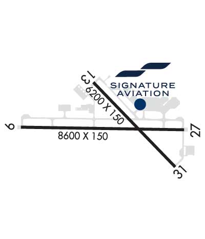
| Lat: N 4153.1 Long: W 09142.6 Elev: 869 Var: -02 Longest Runway: 8600 | ||
| Clr Del: 125.45 Dept. ATIS: 124.15 Arr. ATIS: 124.15 Ground: 121.6 Tower: 118.7 | ||
| ||||||||||||||||||||||||||||||||||||||||||||||||||||||||||||||||||||
| ||||||||||||||||||||||||||||||||||||||||||||||||||||||||||||||||||||
| ||||||||||||||||||||||||||||||||||||||||||||||||||||||||||||||||||||
| ||||||||||||||||||||||||||||||||||||||||||||||||||||||||||||||||||||
| Rwy | Rwy | |||||||
| 8600x150 | 8600' | 109.30 - 088° | 8600x150 | 8175' | 111.30 - 268° | |||
| 6200x150 | 6200' | 6200x150 | 6200' | |||||
| Runway ID | Single Wheel | Double Wheel | Double Tandem Wheel | Dual Double Wheel |
| 09/27 | 120,000 | 227,000 | 360,000 | N/A |
| 13/31 | 120,000 | 172,000 | 360,000 | N/A |
| These numbers are Advisory and are not limits. The Airport Manager should have more accurate Weight Limits | ||||
 Airport Diagram might not be current. | |
| Facility Name: | THE EASTERN IOWA |
| City Name: | CEDAR RAPIDS |
| County: | LINN |
| State abbrev: | IA |
| State Name: | IOWA |
| Ownership: | PUBLICLY OWNED |
| Use: | OPEN TO THE PUBLIC |
| Owner's Name: | CITY OF CEDAR RAPIDS |
| Address: | 101 FIRST STREET SE |
| CEDAR RAPIDS, IA 52401 | |
| Owner's Phone: | 319-362-3131 |
| Manager's Name: | MARTIN LENSS, CM |
| Address: | 2515 ARTHUR COLLINS PKWY SW; EMAIL ADDRESS: T.GIBBS@FLYCID.COM (ALL LOWER CASE) |
| CEDAR RAPIDS, IA 52404-8952 | |
| Phone: | (319) 731-5711 |
| FAA Region: | CENTRAL |
| FAA Field Office: | NONE |
| Date | Sunrise | Sunset |
|---|---|---|
| 03/15/25 Saturday | 7:19 | 19:13 |
| 03/16/25 Sunday | 7:17 | 19:14 |
| 03/17/25 Monday | 7:16 | 19:16 |
| 03/18/25 Tuesday | 7:14 | 19:17 |
| 03/19/25 Wednesday | 7:12 | 19:18 |
| 03/20/25 Thursday | 7:11 | 19:19 |
| 03/21/25 Friday | 7:09 | 19:20 |
| 03/22/25 Saturday | 7:07 | 19:21 |
| 03/23/25 Sunday | 7:05 | 19:22 |
| 03/24/25 Monday | 7:04 | 19:23 |
| 03/25/25 Tuesday | 7:02 | 19:24 |
| 03/26/25 Wednesday | 7:00 | 19:26 |
| 03/27/25 Thursday | 6:59 | 19:27 |
| 03/28/25 Friday | 6:57 | 19:28 |
| Airport Attendance Schedule | MON-FRI 0430-2300, SAT-SUN 0430-2200 |
| Airport Status | OPERATIONAL (This Status can change at any time - please check NOTAMS) |
| Airport Lighting Schedule | WHEN TWR CLSD ACTVT HIRL RY 09/27; MIRL RY 13/31; VASI RY 31, PAPI RYS 13 & 09 AND 27; MALSR RYS 31 & 09 AND 27 (2330-0500) AND TWY LGTS - CTAF. |
| Airport Storage Available | Tie Downs, Hanger |
| Extra Services Available | Air Freight, Air Ambulance, Avionics, Cargo Handling, Charter, Flight Instruction, Aircraft Rental, Aircraft Sales |
| Wind Indicator | YES - (lighted) |
| Control Tower | YES |
| CTAF Frequency | 118.700 |
| Unicom Frequency | 122.950 |
| Rotating Beacon Color | WG |
| Segmented Circle | NO |
| Landing Fee | NO |
| Airport Inspected | FEDERAL - performed by FAA AIRPORTS FIELD PERSONNEL |
| Inspection Date | 09/05/2023 |
| Type of Fuel Available | Grade 100LL, JET A (freeze point -40C); -10FOR FUEL SVC AFTER HRS CALL 319-366-1925. |
| Airframe Repair Service | MAJOR |
| Power Plant Repair Service | MAJOR |
| Latitude | N4153.1 |
| Longitude | W09142.6 (ESTIMATED) |
| Arpt Elevation | 869ft (SURVEYED) |
| Magnetic Variation | 02E |
| 6 miles SW | of CEDAR RAPIDS |
| Traffic Pattern Altitude | |
| Sectional Chart | CHICAGO |
| Operations (Reported) | Yearly | Avg. Daily |
|---|---|---|
| General Aviation Transient | 0 | 0 |
| General Aviation Local | 0 | 0 |
| Air Taxi | 0 | 0 |
| Commerical | 0 | 0 |
| Commuter | 0 | 0 |
| Military | 0 | 0 |
| Aircraft based on Field | |
|---|---|
| General Aviation Singles | 0 |
| General Aviation Multi | 0 |
| Jet Aircraft | 0 |
| General Aviation Helicopters | 0 |
| Military Aircraft | 0 |
| Gliders | 0 |
| Ultralights | 0 |
| FSS on field | NO |
| FSS tie-in | FORT DODGE |
| FSS Phone | 1-800-WX-BRIEF |
| Who issues Notams | CID |
| Notam D service at airport | YES |
| ARTCC Name | CHICAGO |
| Airport Certification | AIRPORT RECEIVING SCHEDULED AIR CARRIER SERVICE FROM CARRIERS CERTIFICATED BY THE CIVIL AERONAUTICS BOARD; INDEX C LEVEL ARFF AVAILABLE UPON REQUEST WITH 48 HRS NOTICE 319-731-5722. |
| Aircraft Rescue & Firefighting Index | AIRPORT HAS A CERTIFICATE UNDER CFR PART 139 |
| Airport of Entry | No |
| Custom Landing Rights | No |
| Joint Civil/Military | No |
| Military Landing rights | YES |
| NATIONAL PLAN OF INTEGRATED AIRPORT SYSTEMS (NPIAS) |
| GRANT AGREEMENTS UNDER FAAP/ADAP/AIP |
| ASSURANCES PURSUANT TO TITLE VI, CIVIL RIGHTS ACT OF 1964 |
| AGREEMENT UNDER DLAND OR DCLA HAS EXPIRED. |
| BIRDS ON & INVOF ARPT. |
| WHEN ATCT CLSD & DURING SNOW & ICE EVENTS; ALL ARR/ DEP ACFT ANNOUNCE THEIR INTENTIONS ON CTAF 5 MINS PRIOR TO USING THE RYS. PERSONNEL & EQUIPMENT PERFORMING SNOW & ICE REMOVAL OPS WILL MONITOR CTAF. |
| TWY D IS NON-MOVEMENT SOUTHEAST OF ARPT ACCESS ROAD. |
| RY 27 IS CALM WIND RY. |
| TRML RAMP IS NON-MOVEMENT. CALL FOR PUSH-BACK NOT RQRD. |
| 100LL SELF FUELING STATION LOCATED ON WEST GA APRON. |
| FOR CD IF UNA TO CTC ON FSS FREQ, CTC CHICAGO ARTCC AT 630-906-8921. |
Airport Communications & Frequencies:
| |||||||||||||||||||||||||||||||||||||||
| Runway: 09 | Runway: 27 | ||
| Mag heading: | 89° | Mag heading: | 269° |
| Rwy Slope: | .07% Up | Rwy Slope: | -.07% Down |
| Approach: | ILS | Approach: | ILS/DME |
| Pattern: | Left Traffic | Pattern: | Left Traffic |
| Markings: | PRECISION INSTRUMENT | Markings: | PRECISION INSTRUMENT |
| Marking Condition: | GOOD | Marking Condition: | GOOD |
| Arresting Dev: | Arresting Dev: | ||
| Lat & Long: | N4153.1 W09143.8 | Lat. & Long.: | N4153.1 W09141.9 |
| Elev: | 854.0 ft. MSL | Elev: | 859.8 ft. MSL |
| TCH: | 60 ft. AGL | TCH: | 46 ft. AGL |
| Visual Glide Path: | 3.00 degrees | Visual Glide Path: | 3.00 degrees |
| Displaced Threshold: | No | Displaced Threshold: | 425 feet |
| Touchdown Zone: | YES | Touchdown Zone: | YES |
| Touchdown Elev.: | 856.9 feet | Touchdown Elev.: | 861.7 feet |
| Visual Glide Slope: | 4-Light PAPI on RIGHT side of Runway | Visual Glide Slope: | 4-Light PAPI on LEFT side of Runway |
| RVR Equipment: | TOUCHDOWN-ROLLOUT | RVR Equipment: | TOUCHDOWN-ROLLOUT |
| RVV Equipment: | NO | RVV Equipment: | NO |
| Approach Lights: | MALSR - 1,400 foot medium intensity approach lighting system with runway alignment indicator lights | Approach Lights: | MALSR - 1,400 foot medium intensity approach lighting system with runway alignment indicator lights |
| REIL: | NO | REIL: | NO |
| Centerline Lights: | NO | Centerline Lights: | NO |
| Touchdown lights: | NO | Touchdown lights: | NO |
| Runway Category: | Precision Instrument Runway | Runway Category: | Precision Instrument Runway |
| Declared Distances: | TORA:8600' TODA:8600' ASDA:8175' LDA:8175' | Declared Distances: | TORA:8600' TODA:8600' ASDA:8600' LDA:8175' |
| Obstructions: | Obstructions: | RR | |
| Marked: | Marked: | NOT Marked/Lighted | |
| Clearance slope: | 50:1 | Clearance slope: | 39:1 |
| Obstruction height: | Obstruction height: | 14 feet AGL | |
| Dist. from runway: | Dist. from runway: | 740 feet | |
| Centerline offset: | Centerline offset: | ||
| Comments: | Comments: |
| Runway: 13 | Runway: 31 | ||
| Mag heading: | 134° | Mag heading: | 314° |
| Rwy Slope: | -.35% Down | Rwy Slope: | .35% Up |
| Approach: | Approach: | ||
| Pattern: | Left Traffic | Pattern: | Left Traffic |
| Markings: | NONPRECISION INSTRUMENT | Markings: | NONPRECISION INSTRUMENT |
| Marking Condition: | GOOD | Marking Condition: | GOOD |
| Arresting Dev: | Arresting Dev: | ||
| Lat & Long: | N4153.5 W09142.9 | Lat. & Long.: | N4152.7 W09142.0 |
| Elev: | 869.3 ft. MSL | Elev: | 847.6 ft. MSL |
| TCH: | 51 ft. AGL | TCH: | 50 ft. AGL |
| Visual Glide Path: | 3.00 degrees | Visual Glide Path: | 3.00 degrees |
| Displaced Threshold: | No | Displaced Threshold: | No |
| Touchdown Zone: | YES | Touchdown Zone: | YES |
| Touchdown Elev.: | 869.4 feet | Touchdown Elev.: | 861.0 feet |
| Visual Glide Slope: | 4-Light PAPI on LEFT side of Runway | Visual Glide Slope: | 4-BOX VASI ON LEFT SIDE OF RUNWAY |
| RVR Equipment: | RVR Equipment: | ||
| RVV Equipment: | NO | RVV Equipment: | NO |
| Approach Lights: | Approach Lights: | MALSR - 1,400 foot medium intensity approach lighting system with runway alignment indicator lights | |
| REIL: | YES | REIL: | NO |
| Centerline Lights: | NO | Centerline Lights: | NO |
| Touchdown lights: | NO | Touchdown lights: | NO |
| Runway Category: | Runway with a Non-precision Approach having visibility minimums greater than 3/4 mile | Runway Category: | D |
| Declared Distances: | TORA:6200' TODA:6200' ASDA:6200' LDA:6200' | Declared Distances: | TORA:6200' TODA:6200' ASDA:6200' LDA:6200' |
Thanks for using FltPlan.com
all rights reserved © 1999-2025 by Flight Plan LLC


