
| NATRONA COUNTY INTL CASPER WY |
| |
| Lat: N 4254.4 Long: W 10627.8 Elev: 5344 Var: -12 Longest Runway: 10165 | ||
| Clr Del: 121.9 Dept. ATIS: 126.15 Arr. ATIS: 126.15 AWOS: 126.15 Ground: 121.9 Tower: 118.3 | ||
| ||||||||||||||||||||||||||||||||||||||||||||||||||||||||||||||||||||
| ||||||||||||||||||||||||||||||||||||||||||||||||||||||||||||||||||||
| ||||||||||||||||||||||||||||||||||||||||||||||||||||||||||||||||||||
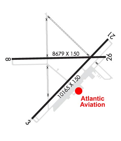
| Rwy | Rwy | |||||||
| 10165x150 | 10165' | 111.30 - 031° | 10165x150 | 10165' | ||||
| 8679x150 | 8679' | 110.30 - 077° | 8679x150 | 8679' | ||||
| Runway ID | Single Wheel | Double Wheel | Double Tandem Wheel | Dual Double Wheel |
| 03/21 | 130,000 | 170,000 | 270,000 | N/A |
| 08/26 | 85,000 | 140,000 | 260,000 | N/A |
| These numbers are Advisory and are not limits. The Airport Manager should have more accurate Weight Limits | ||||
 Airport Diagram might not be current. | |
| Facility Name: | CASPER/NATRONA COUNTY INTL |
| City Name: | CASPER |
| County: | NATRONA |
| State abbrev: | WY |
| State Name: | WYOMING |
| Ownership: | PUBLICLY OWNED |
| Use: | OPEN TO THE PUBLIC |
| Owner's Name: | COUNTY BOARD OF COMMISSIONERS |
| Address: | 8500 AIRPORT PARKWAY, SUITE 208 |
| CASPER, WY 82604 | |
| Owner's Phone: | 307-472-6688 |
| Manager's Name: | GLENN JANUSKA |
| Address: | 8500 AIRPORT PARKWAY, SUITE 208 |
| CASPER, WY 82604 | |
| Phone: | 307-472-6688 |
| FAA Region: | NORTHWEST MOUNTAIN |
| FAA Field Office: | DEN |
| Date | Sunrise | Sunset |
|---|---|---|
| 09/24/21 Friday | 6:55 | 19:00 |
| 09/25/21 Saturday | 6:56 | 18:58 |
| 09/26/21 Sunday | 6:57 | 18:56 |
| 09/27/21 Monday | 6:58 | 18:55 |
| 09/28/21 Tuesday | 7:00 | 18:53 |
| 09/29/21 Wednesday | 7:01 | 18:51 |
| 09/30/21 Thursday | 7:02 | 18:49 |
| 10/01/21 Friday | 7:03 | 18:47 |
| 10/02/21 Saturday | 7:04 | 18:46 |
| 10/03/21 Sunday | 7:05 | 18:44 |
| 10/04/21 Monday | 7:06 | 18:42 |
| 10/05/21 Tuesday | 7:07 | 18:40 |
| 10/06/21 Wednesday | 7:09 | 18:39 |
| 10/07/21 Thursday | 7:10 | 18:37 |
| Airport Attendance Schedule | CONTINUOUS |
| Airport Status | OPERATIONAL (This Status can change at any time - please check NOTAMS) |
| Airport Lighting Schedule | ATC-CTL. WHEN ATCT CLSD ACTVT HIRL RYS 03/21 & 08/26, MALSR RYS 03 & 08, AND TWY LGTS - CTAF. |
| Airport Storage Available | Tie Downs, Hanger |
| Extra Services Available | Air Freight, Air Ambulance, Avionics, Cargo Handling, Charter, Flight Instruction, Aircraft Rental, Aircraft Sales, Annual Surveying |
| Wind Indicator | YES - (lighted) |
| Control Tower | YES |
| CTAF Frequency | 118.300 |
| Unicom Frequency | 122.950 |
| Rotating Beacon Color | CLEAR-GREEN (Light Land Airport) |
| Segmented Circle | YES |
| Landing Fee | NO |
| Airport Inspected | FEDERAL - performed by FAA AIRPORTS FIELD PERSONNEL |
| Inspection Date | 11/08/2019 |
| Type of Fuel Available | Grade 100LL, JET A (freeze point -40C) |
| Airframe Repair Service | MAJOR |
| Power Plant Repair Service | MAJOR |
| Latitude | N4254.4 |
| Longitude | W10627.8 (ESTIMATED) |
| Arpt Elevation | 5344ft (SURVEYED) |
| Magnetic Variation | 12E |
| 7 miles NW | of CASPER |
| Traffic Pattern Altitude | |
| Sectional Chart | CHEYENNE |
| Operations (Reported) | Yearly | Avg. Daily |
|---|---|---|
| General Aviation Transient | 15732 | 43 |
| General Aviation Local | 6072 | 17 |
| Air Taxi | 10280 | 28 |
| Commerical | 2176 | 6 |
| Commuter | 0 | 0 |
| Military | 602 | 2 |
| Aircraft based on Field | |
|---|---|
| General Aviation Singles | 105 |
| General Aviation Multi | 11 |
| Jet Aircraft | 7 |
| General Aviation Helicopters | 8 |
| Military Aircraft | 0 |
| Gliders | 0 |
| Ultralights | 0 |
| FSS on field | NO |
| FSS tie-in | CASPER |
| FSS Phone | 1-800-WX-BRIEF |
| Who issues Notams | CPR |
| Notam D service at airport | YES |
| ARTCC Name | DENVER |
| Airport Certification | AIRPORT RECEIVING SCHEDULED AIR CARRIER SERVICE FROM CARRIERS CERTIFICATED BY THE CIVIL AERONAUTICS BOARD |
| Aircraft Rescue & Firefighting Index | AIRPORT HAS A CERTIFICATE UNDER CFR PART 139 |
| Airport of Entry | No |
| Custom Landing Rights | YES |
| Joint Civil/Military | No |
| Military Landing rights | YES |
| NATIONAL PLAN OF INTEGRATED AIRPORT SYSTEMS (NPIAS) |
| GRANT AGREEMENTS UNDER FAAP/ADAP/AIP |
| SURPLUS PROPERTY AGREEMENT UNDER PUBLIC LAW 289 |
| ASSURANCES PURSUANT TO TITLE VI, CIVIL RIGHTS ACT OF 1964 |
| EMERG PWR AVBL RYS 08/26 & 03/21. |
| RY 08/26 & RY 03/21 HAVE LGTD DISTANCE REMAINING SIGNS. |
| 225 FT CRANE 1 NM NE OF ARPT. |
| RUNWAYS CLOSED TO FSL, TGL, AND PLA AIRCRAFT MORE THAN 250,000 POUNDS EXCEPT FOR 4 HOURS PPR 307-995-3950. |
| RUNWAYS CLOSED TO FSL, TGL, AND PLA AIRCRAFT MORE THAN 250,000 POUNDS EXCEPT FOR 4 HOURS PPR. |
| FOR CD CTC CASPER APCH AT 307-472-8940, WHEN APCH CLSD CTC DENVER ARTCC AT 303-651-4257. |
Airport Communications & Frequencies:
| |||||||||||||||||||||||||||||||||
| Runway: 03 | Runway: 21 | ||
| Mag heading: | 32° | Mag heading: | 212° |
| Rwy Slope: | .02% Up | Rwy Slope: | -.02% Down |
| Approach: | ILS | Approach: | |
| Pattern: | Left Traffic | Pattern: | Left Traffic |
| Markings: | PRECISION INSTRUMENT | Markings: | PRECISION INSTRUMENT |
| Marking Condition: | GOOD | Marking Condition: | GOOD |
| Arresting Dev: | Arresting Dev: | ||
| Lat & Long: | N4253.6 W10628.5 | Lat. & Long.: | N4254.8 W10626.9 |
| Elev: | 5324.2 ft. MSL | Elev: | 5326.1 ft. MSL |
| TCH: | 50 ft. AGL | TCH: | 56 ft. AGL |
| Visual Glide Path: | 3.00 degrees | Visual Glide Path: | 3.00 degrees |
| Displaced Threshold: | No | Displaced Threshold: | No |
| Touchdown Zone: | YES | Touchdown Zone: | YES |
| Touchdown Elev.: | 5327.9 feet | Touchdown Elev.: | 5329.8 feet |
| Visual Glide Slope: | 4-Light PAPI on RIGHT side of Runway | Visual Glide Slope: | 4-BOX VASI ON LEFT SIDE OF RUNWAY |
| RVR Equipment: | TOUCHDOWN | RVR Equipment: | ROLLOUT |
| RVV Equipment: | YES | RVV Equipment: | NO |
| Approach Lights: | MALSR - 1,400 foot medium intensity approach lighting system with runway alignment indicator lights | Approach Lights: | |
| REIL: | NO | REIL: | YES |
| Centerline Lights: | NO | Centerline Lights: | NO |
| Touchdown lights: | NO | Touchdown lights: | NO |
| Runway Category: | Precision Instrument Runway | Runway Category: | Runway with a Non-precision Approach having visibility minimums greater than 3/4 mile |
| Declared Distances: | TORA:10165' TODA:10165' ASDA:10165' LDA:10165' | Declared Distances: | TORA:10165' TODA:10165' ASDA:10165' LDA:10165' |
| Runway: 08 | Runway: 26 | ||
| Mag heading: | 77° | Mag heading: | 257° |
| Rwy Slope: | -.23% Down | Rwy Slope: | .23% Up |
| Approach: | ILS | Approach: | |
| Pattern: | Left Traffic | Pattern: | Left Traffic |
| Markings: | PRECISION INSTRUMENT | Markings: | PRECISION INSTRUMENT |
| Marking Condition: | GOOD | Marking Condition: | GOOD |
| Arresting Dev: | Arresting Dev: | ||
| Lat & Long: | N4254.5 W10628.9 | Lat. & Long.: | N4254.5 W10627.0 |
| Elev: | 5343.8 ft. MSL | Elev: | 5323.5 ft. MSL |
| TCH: | 103 ft. AGL | TCH: | 50 ft. AGL |
| Visual Glide Path: | 3.00 degrees | Visual Glide Path: | 3.00 degrees |
| Displaced Threshold: | No | Displaced Threshold: | No |
| Touchdown Zone: | YES | Touchdown Zone: | YES |
| Touchdown Elev.: | 5344.0 feet | Touchdown Elev.: | 5335.0 feet |
| Visual Glide Slope: | 4-BOX VASI ON RIGHT SIDE OF RUNWAY | Visual Glide Slope: | 4-Light PAPI on RIGHT side of Runway |
| RVR Equipment: | TOUCHDOWN | RVR Equipment: | ROLLOUT |
| RVV Equipment: | YES | RVV Equipment: | NO |
| Approach Lights: | MALSR - 1,400 foot medium intensity approach lighting system with runway alignment indicator lights | Approach Lights: | |
| REIL: | NO | REIL: | YES |
| Centerline Lights: | NO | Centerline Lights: | NO |
| Touchdown lights: | NO | Touchdown lights: | NO |
| Runway Category: | Precision Instrument Runway | Runway Category: | Runway with a Non-precision Approach having visibility minimums greater than 3/4 mile |
| Declared Distances: | TORA:8679' TODA:8679' ASDA:8679' LDA:8679' | Declared Distances: | TORA:8679' TODA:8679' ASDA:8679' LDA:8679' |
Thanks for using FltPlan.com
all rights reserved © 1999-2021 by Flight Plan LLC


