| CONROE-NORTH HOUSTON REGL HOUSTON TX |
| |
| Lat: N 3021.2 Long: W 09524.9 Elev: 245 Var: -05 Longest Runway: 7501 | ||
| Clr Del: 119.55 TW CLD Dept. ATIS: 118.32 Arr. ATIS: 118.32 AWOS: 118.32 Ground: 120.45 Tower: 124.12 | ||
| |||||||||||||||||||||||||||||||||||||||
| |||||||||||||||||||||||||||||||||||||||
| |||||||||||||||||||||||||||||||||||||||
| |||||||||||||||||||||||||||||||||||||||
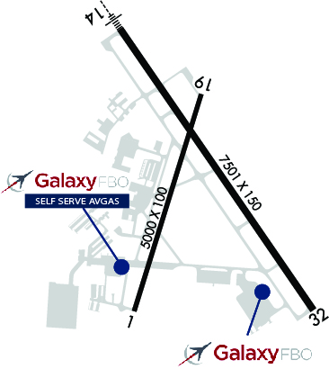
| FBOs at nearby airports who want your business: | |||||||||||||||||
| |||||||||||||||||
| Rwy | Rwy | |||||||
| 5000x100 | 5000' | 5000x100 | 5000' | |||||
| 7501x150 | 7501' | 108.70 - 140° | 7501x150 | 7501' | ||||
| Runway ID | Single Wheel | Double Wheel | Double Tandem Wheel | Dual Double Wheel |
| 01/19 | 30,000 | 75,000 | N/A | N/A |
| 14/32 | 60,000 | 100,000 | N/A | N/A |
| These numbers are Advisory and are not limits. The Airport Manager should have more accurate Weight Limits | ||||
 Airport Diagram might not be current. | |
| Facility Name: | CONROE/NORTH HOUSTON RGNL |
| City Name: | HOUSTON |
| County: | MONTGOMERY |
| State abbrev: | TX |
| State Name: | TEXAS |
| Ownership: | PUBLICLY OWNED |
| Use: | OPEN TO THE PUBLIC |
| Owner's Name: | MONTGOMERY COUNTY |
| Address: | 501 N. THOMPSON ST. |
| CONROE, TX 77301 | |
| Owner's Phone: | 936-539-7811 |
| Manager's Name: | JAMES BROWN |
| Address: | 10260 CARL PICKERING MEMORIAL |
| CONROE, TX 77303 | |
| Phone: | 936-788-8311 |
| FAA Region: | SOUTHWEST |
| FAA Field Office: | TEX |
| Date | Sunrise | Sunset |
|---|---|---|
| 02/06/25 Thursday | 7:09 | 18:03 |
| 02/07/25 Friday | 7:09 | 18:03 |
| 02/08/25 Saturday | 7:08 | 18:04 |
| 02/09/25 Sunday | 7:07 | 18:05 |
| 02/10/25 Monday | 7:06 | 18:06 |
| 02/11/25 Tuesday | 7:06 | 18:07 |
| 02/12/25 Wednesday | 7:05 | 18:08 |
| 02/13/25 Thursday | 7:04 | 18:08 |
| 02/14/25 Friday | 7:03 | 18:09 |
| 02/15/25 Saturday | 7:02 | 18:10 |
| 02/16/25 Sunday | 7:01 | 18:11 |
| 02/17/25 Monday | 7:00 | 18:12 |
| 02/18/25 Tuesday | 6:59 | 18:12 |
| 02/19/25 Wednesday | 6:58 | 18:13 |
| Airport Attendance Schedule | SAT-SUN 0800-1600, MON-FRI 0800-1700 |
| Airport Status | OPERATIONAL (This Status can change at any time - please check NOTAMS) |
| Airport Lighting Schedule | HIRL RWY 14/32 PRESET LOW INTST; TO INCR INTST & ACTVT REIL RWY 32 - CTAF. |
| Airport Storage Available | Tie Downs, Hanger |
| Extra Services Available | Avionics, Charter, Flight Instruction, Aircraft Rental |
| Wind Indicator | YES - (lighted) |
| Control Tower | YES |
| CTAF Frequency | 124.125 |
| Unicom Frequency | |
| Rotating Beacon Color | WG |
| Segmented Circle | YES |
| Landing Fee | NO |
| Airport Inspected | STATE - performed by PRIVATE CONTRACT PERSONNEL |
| Inspection Date | 04/10/2023 |
| Type of Fuel Available | Grade 100LL, JET A (freeze point -40C) |
| Airframe Repair Service | MAJOR |
| Power Plant Repair Service | MAJOR |
| Latitude | N3021.2 |
| Longitude | W09524.9 (ESTIMATED) |
| Arpt Elevation | 244ft (SURVEYED) |
| Magnetic Variation | 05E |
| 37 miles N | of HOUSTON |
| Traffic Pattern Altitude | |
| Sectional Chart | HOUSTON |
| Operations (Reported) | Yearly | Avg. Daily |
|---|---|---|
| General Aviation Transient | 0 | 0 |
| General Aviation Local | 0 | 0 |
| Air Taxi | 0 | 0 |
| Commerical | 0 | 0 |
| Commuter | 0 | 0 |
| Military | 0 | 0 |
| Aircraft based on Field | |
|---|---|
| General Aviation Singles | 0 |
| General Aviation Multi | 0 |
| Jet Aircraft | 0 |
| General Aviation Helicopters | 0 |
| Military Aircraft | 0 |
| Gliders | 0 |
| Ultralights | 0 |
| FSS on field | NO |
| FSS tie-in | MONTGOMERY COUNTY |
| FSS Phone | 1-800-WX-BRIEF |
| Who issues Notams | CXO |
| Notam D service at airport | YES |
| ARTCC Name | HOUSTON |
| Airport Certification | |
| Aircraft Rescue & Firefighting Index | None |
| Airport of Entry | No |
| Custom Landing Rights | No; US CUSTOMS USER FEE ARPT. |
| Joint Civil/Military | No |
| Military Landing rights | YES |
| NATIONAL PLAN OF INTEGRATED AIRPORT SYSTEMS (NPIAS) |
| GRANT AGREEMENTS UNDER FAAP/ADAP/AIP |
| SURPLUS PROPERTY AGREEMENT UNDER PUBLIC LAW 289 |
| ASSURANCES PURSUANT TO TITLE VI, CIVIL RIGHTS ACT OF 1964 |
| AGREEMENT UNDER DLAND OR DCLA HAS EXPIRED. |
| EXTSV MIL HEL ACTVY ON ARPT. |
| (A23) HELS USE RIGHT-HAND TFC. |
| AVOID NOISE SENSITIVE AREA 10 MI SW QUAD OF ARPT. |
| MIL SVC FUEL 0600-2100 C936-494-4252. |
| FOR CD WHEN ATCT CLSD CTC HOUSTON APCH AT 281-443-5844, TO CNL IFR AT 281-443-5888. |
| EXTV STUDENT PILOT (SUNRISE TO SUNSET). |
Airport Communications & Frequencies:
| ||||||||||||||||||||||
| Runway: 01 | Runway: 19 | ||
| Mag heading: | 12° | Mag heading: | 192° |
| Rwy Slope: | -.02% Down | Rwy Slope: | .02% Up |
| Approach: | Approach: | ||
| Pattern: | Left Traffic | Pattern: | Left Traffic |
| Markings: | NONPRECISION INSTRUMENT | Markings: | NONPRECISION INSTRUMENT |
| Marking Condition: | GOOD | Marking Condition: | GOOD |
| Arresting Dev: | Arresting Dev: | ||
| Lat & Long: | N3020.7 W09525.2 | Lat. & Long.: | N3021.5 W09524.9 |
| Elev: | 229.6 ft. MSL | Elev: | 228.7 ft. MSL |
| TCH: | 49 ft. AGL | TCH: | 49 ft. AGL |
| Visual Glide Path: | 3.15 degrees | Visual Glide Path: | 3.00 degrees |
| Displaced Threshold: | No | Displaced Threshold: | No |
| Touchdown Zone: | YES | Touchdown Zone: | YES |
| Touchdown Elev.: | 236.7 feet | Touchdown Elev.: | 236.7 feet |
| Visual Glide Slope: | 2-Light PAPI on LEFT side of Runway | Visual Glide Slope: | 2-Light PAPI on LEFT side of Runway |
| RVR Equipment: | RVR Equipment: | ||
| RVV Equipment: | NO | RVV Equipment: | NO |
| Approach Lights: | Approach Lights: | ||
| REIL: | NO | REIL: | NO |
| Centerline Lights: | NO | Centerline Lights: | NO |
| Touchdown lights: | NO | Touchdown lights: | NO |
| Runway Category: | Runway with a Non-precision Approach having visibility minimums greater than 3/4 mile | Runway Category: | Runway with a Non-precision Approach having visibility minimums greater than 3/4 mile |
| Declared Distances: | TORA:5000' TODA:5000' ASDA:5000' LDA:5000' | Declared Distances: | TORA:5000' TODA:5000' ASDA:5000' LDA:5000' |
| Obstructions: | TREES | Obstructions: | TREES |
| Marked: | NOT Marked/Lighted | Marked: | NOT Marked/Lighted |
| Clearance slope: | 20:1 | Clearance slope: | 24:1 |
| Obstruction height: | 56 feet AGL | Obstruction height: | 50 feet AGL |
| Dist. from runway: | 1350 feet | Dist. from runway: | 1400 feet |
| Centerline offset: | 460B | Centerline offset: | 460B |
| Comments: | Comments: |
| Runway: 14 | Runway: 32 | ||
| Mag heading: | 140° | Mag heading: | 320° |
| Rwy Slope: | .09% Up | Rwy Slope: | -.09% Down |
| Approach: | ILS/DME | Approach: | |
| Pattern: | Left Traffic | Pattern: | Left Traffic |
| Markings: | PRECISION INSTRUMENT | Markings: | NONPRECISION INSTRUMENT |
| Marking Condition: | GOOD | Marking Condition: | GOOD |
| Arresting Dev: | Arresting Dev: | ||
| Lat & Long: | N3021.8 W09525.2 | Lat. & Long.: | N3020.7 W09524.4 |
| Elev: | 234.1 ft. MSL | Elev: | 241.1 ft. MSL |
| TCH: | 47 ft. AGL | TCH: | 50 ft. AGL |
| Visual Glide Path: | 3.00 degrees | Visual Glide Path: | 3.00 degrees |
| Displaced Threshold: | No | Displaced Threshold: | No |
| Touchdown Zone: | YES | Touchdown Zone: | YES |
| Touchdown Elev.: | 235.9 feet | Touchdown Elev.: | 244.8 feet |
| Visual Glide Slope: | 4-Light PAPI on LEFT side of Runway | Visual Glide Slope: | 2-Light PAPI on LEFT side of Runway |
| RVR Equipment: | RVR Equipment: | ||
| RVV Equipment: | NO | RVV Equipment: | NO |
| Approach Lights: | MALSR - 1,400 foot medium intensity approach lighting system with runway alignment indicator lights | Approach Lights: | |
| REIL: | NO | REIL: | YES |
| Centerline Lights: | NO | Centerline Lights: | NO |
| Touchdown lights: | NO | Touchdown lights: | NO |
| Runway Category: | Precision Instrument Runway | Runway Category: | Runway with a Non-precision Approach having visibility minimums greater than 3/4 mile |
| Declared Distances: | Declared Distances: | ||
| Obstructions: | TREES | Obstructions: | Unknown |
| Marked: | NOT Marked/Lighted | Marked: | NOT Marked/Lighted |
| Clearance slope: | 34:1 | Clearance slope: | 34:1 |
| Obstruction height: | 73 feet AGL | Obstruction height: | 59 feet AGL |
| Dist. from runway: | 2700 feet | Dist. from runway: | 2250 feet |
| Centerline offset: | Centerline offset: | 228 feet left of centerline | |
| Comments: | Comments: |
Thanks for using FltPlan.com
all rights reserved © 1999-2025 by Flight Plan LLC