
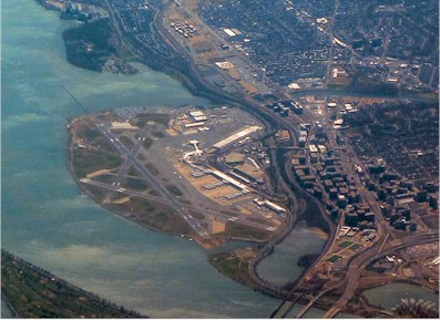
| RONALD REAGAN WASHINGTON NTNL WASHINGTON DC VA |
| |
| Lat: N 3851.1 Long: W 07702.3 Elev: 14 Var: +11 Longest Runway: 7169 | ||
| Clr Del: 128.25 Dept. ATIS: 132.65 Arr. ATIS: 132.65 AWOS: 128.8 Ground: 121.7 Tower: 119.1 | ||
| ||||||||||||||||||||||||||||||||||||||||||||
| ||||||||||||||||||||||||||||||||||||||||||||
| ||||||||||||||||||||||||||||||||||||||||||||
| ||||||||||||||||||||||||||||||||||||||||||||
| Rwy | Rwy | |||||||
| 7169x150 | 7169' | 109.90 - 006° | 7169x150 | 7169' | 109.90 - 149° | |||
| 5000x150 | 4800' | 5000x150 | 5000' | |||||
| 5204x150 | 5204' | 5204x150 | 5204' | |||||
| Runway ID | Single Wheel | Double Wheel | Double Tandem Wheel | Dual Double Wheel |
| 01/19 | 110,000 | 200,000 | 360,000 | N/A |
| 04/22 | 110,000 | 200,000 | 360,000 | N/A |
| 15/33 | 110,000 | 200,000 | 360,000 | N/A |
| 19X | N/A | N/A | N/A | N/A |
| These numbers are Advisory and are not limits. The Airport Manager should have more accurate Weight Limits | ||||
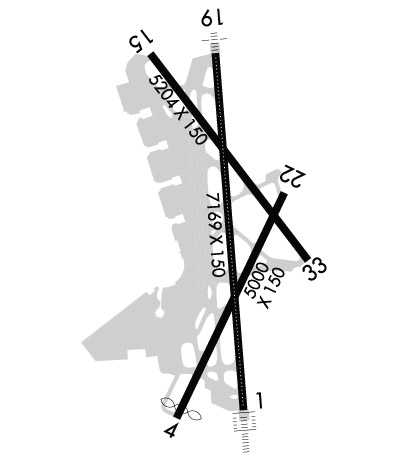 Airport Diagram might not be current. | |
| Facility Name: | RONALD REAGAN WASHINGTON NTL |
| City Name: | WASHINGTON |
| County: | ARLINGTON |
| State abbrev: | DC |
| State Name: | DIST. OF COLUMBIA |
| Ownership: | PUBLICLY OWNED |
| Use: | OPEN TO THE PUBLIC |
| Owner's Name: | METRO WASH ARPT AUTHORITY |
| Address: | 1 AVIATION CIRCLE |
| WASHINGTON, DC 20001-6000 | |
| Owner's Phone: | 703-417-8600 |
| Manager's Name: | PAUL MALANDRINO, JR. |
| Address: | 1 AVIATION CIRCLE |
| WASHINGTON, DC 20001-6000 | |
| Phone: | 703-417-8050 |
| FAA Region: | EASTERN |
| FAA Field Office: | DCA |
| Date | Sunrise | Sunset |
|---|---|---|
| 09/24/21 Friday | 6:57 | 19:02 |
| 09/25/21 Saturday | 6:58 | 19:01 |
| 09/26/21 Sunday | 6:59 | 18:59 |
| 09/27/21 Monday | 7:00 | 18:58 |
| 09/28/21 Tuesday | 7:01 | 18:56 |
| 09/29/21 Wednesday | 7:02 | 18:54 |
| 09/30/21 Thursday | 7:03 | 18:53 |
| 10/01/21 Friday | 7:04 | 18:51 |
| 10/02/21 Saturday | 7:05 | 18:50 |
| 10/03/21 Sunday | 7:06 | 18:48 |
| 10/04/21 Monday | 7:07 | 18:47 |
| 10/05/21 Tuesday | 7:08 | 18:45 |
| 10/06/21 Wednesday | 7:09 | 18:43 |
| 10/07/21 Thursday | 7:09 | 18:42 |
| Airport Attendance Schedule | CONTINUOUS |
| Airport Status | OPERATIONAL (This Status can change at any time - please check NOTAMS) |
| Airport Lighting Schedule | |
| Airport Storage Available | Tie Downs, Hanger |
| Extra Services Available | Cargo Handling |
| Wind Indicator | YES - (lighted) |
| Control Tower | YES |
| CTAF Frequency | |
| Unicom Frequency | 122.950 |
| Rotating Beacon Color | CLEAR-GREEN (Light Land Airport) |
| Segmented Circle | NO |
| Landing Fee | YES |
| Airport Inspected | FEDERAL - performed by FAA AIRPORTS FIELD PERSONNEL |
| Inspection Date | 10/21/2019 |
| Type of Fuel Available | JET A (freeze point -40C) |
| Airframe Repair Service | MINOR |
| Power Plant Repair Service | MINOR |
| Latitude | N3851.1 |
| Longitude | W07702.3 (ESTIMATED) |
| Arpt Elevation | 14ft (SURVEYED) |
| Magnetic Variation | 11W |
| 3 miles S | of WASHINGTON |
| Traffic Pattern Altitude | |
| Sectional Chart | WASHINGTON |
| Operations (Reported) | Yearly | Avg. Daily |
|---|---|---|
| General Aviation Transient | 2836 | 8 |
| General Aviation Local | 0 | 0 |
| Air Taxi | 52704 | 144 |
| Commerical | 239759 | 657 |
| Commuter | 0 | 0 |
| Military | 2784 | 8 |
| Aircraft based on Field | |
|---|---|
| General Aviation Singles | 0 |
| General Aviation Multi | 0 |
| Jet Aircraft | 0 |
| General Aviation Helicopters | 0 |
| Military Aircraft | 0 |
| Gliders | 0 |
| Ultralights | 0 |
| FSS on field | NO |
| FSS tie-in | LEESBURG |
| FSS Phone | 1-800-WX-BRIEF |
| Who issues Notams | DCA |
| Notam D service at airport | YES |
| ARTCC Name | WASHINGTON |
| Airport Certification | AIRPORT RECEIVING SCHEDULED AIR CARRIER SERVICE FROM CARRIERS CERTIFICATED BY THE CIVIL AERONAUTICS BOARD |
| Aircraft Rescue & Firefighting Index | AIRPORT HAS A CERTIFICATE UNDER CFR PART 139 |
| Airport of Entry | No |
| Custom Landing Rights | YES |
| Joint Civil/Military | No |
| Military Landing rights | No |
| NATIONAL PLAN OF INTEGRATED AIRPORT SYSTEMS (NPIAS) |
| GRANT AGREEMENTS UNDER FAAP/ADAP/AIP |
| OBLIGATIONS ASSUMED BY TRANSFER |
| ASSURANCES PURSUANT TO TITLE VI, CIVIL RIGHTS ACT OF 1964 |
| COMPLIANCE WITH ACCESSIBILITY TO THE HANDICAPPED |
| TWY K ENDS AT GATE 5. |
| FLOCKS OF BIRDS ON & INVOF ARPT; FQT GULL & GEESE & DUCK POPULATIONS AB OVER ADJ RIVER AREAS. |
| TRNG FLIGHTS THAT INCLUDE MULTIPLE APCHS AND/OR TOUCH & GO OPNS REQUIRE PRIOR PERMISSION FM THE ARPT MGR. |
| LEFT-HAND TURN-OFFS FROM RY 33 TO TWY 'K' PROHIBITED. |
| ACFT ARRIVING/DEPARTING THE GA PARKING AREA ARE PROHIBITED FM TAXING BTN ACR PUSHBACK OPNS & THE GATES. |
| BE ADVISED SOME AIRCREWS MISTAKE RY 15 FOR RY 19. |
| ASDE-X IN USE. OPERATE TRANSPONDERS WITH ALTITUDE REPORTING MODE AND ADS-B (IF EQUIPPED) ENABLED ON ALL AIRPORT SURFACES. |
| RONALD REAGAN WASHINGTON NATIONAL ARPRT (KDCA) IS AN EMERGENCY USE ONLY FIELD FOR ALL DOD OWNED AND OPERATED ACFT. |
| TWY N BTN APCH END RWY 15 AND TWY K CLSD TO ACFT WINGSPAN MORE THAN 124FT. |
| LGTG FM VEHICLE PARKING LOT LCTD 1000 FT SW OF RY 01 COULD GIVE FALSE INDICATIONS OF BEING PART OF RY 01 APCH LGTG SYS DURG PERIODS OF REDUCED VSBY & LOW CEILINGS. |
| FORM 150R CREDIT CARD FOR ALL RQRD SVCS. NO MIL FACS. |
| RWY 19X THIS RY EXISTS TO SUPPORT THE DCA LDA ASSOCIATED WITH THE ILS. |
Airport Communications & Frequencies:
| |||||||||||||||||||||||||||||||||||||||||||||||||||
| Runway: 01 | Runway: 19 | ||
| Mag heading: | 7° | Mag heading: | 186° |
| Rwy Slope: | .01% Up | Rwy Slope: | -.01% Down |
| Approach: | ILS/DME | Approach: | LDA/DME |
| Pattern: | Left Traffic | Pattern: | Right Traffic |
| Markings: | PRECISION INSTRUMENT | Markings: | PRECISION INSTRUMENT |
| Marking Condition: | GOOD | Marking Condition: | GOOD |
| Arresting Dev: | Arresting Dev: | ||
| Lat & Long: | N3850.5 W07702.2 | Lat. & Long.: | N3851.7 W07702.3 |
| Elev: | 11.4 ft. MSL | Elev: | 12.1 ft. MSL |
| TCH: | 54 ft. AGL | TCH: | 50 ft. AGL |
| Visual Glide Path: | 3.00 degrees | Visual Glide Path: | 3.00 degrees |
| Displaced Threshold: | No | Displaced Threshold: | No |
| Touchdown Zone: | YES | Touchdown Zone: | YES |
| Touchdown Elev.: | 13.9 feet | Touchdown Elev.: | 13.1 feet |
| Visual Glide Slope: | 4-Light PAPI on RIGHT side of Runway | Visual Glide Slope: | 12-BOX VASI ON BOTH SIDES OF RUNWAY; RWY 19 VASI (V12) CONSISTS OF TWO (2) VASI-V6 SYSTEMS (L/R). RWY 19 V6R IS ROTATED 20 DEGS TO R AND EXTDS COVERAGE TO 24 DEGS R OF CNTRLN. THE ROTATED VASI-V6R SYSTEM SUPPORTS VISUAL AND INSTR APCHS TO RWY 19. |
| RVR Equipment: | TOUCHDOWN-ROLLOUT | RVR Equipment: | TOUCHDOWN-ROLLOUT |
| RVV Equipment: | NO | RVV Equipment: | NO |
| Approach Lights: | ALSF2 - standard 2,400 foot high intensity approach lighting system with sequenced flashers, Category II or III | Approach Lights: | MALSF - 1,400 foot medium intensity approach lighting system with sequenced flashers |
| REIL: | NO | REIL: | NO |
| Centerline Lights: | YES | Centerline Lights: | YES |
| Touchdown lights: | YES | Touchdown lights: | NO |
| Runway Category: | Precision Instrument Runway | Runway Category: | Runway with a Non-precision Approach having visibility minimums greater than 3/4 mile |
| Declared Distances: | TORA:6869' TODA:6869' ASDA:6869' LDA:6869' | Declared Distances: | TORA:6869' TODA:6869' ASDA:6869' LDA:6869' |
| Obstructions: | TOWER | Obstructions: | TREE |
| Marked: | LIGHTED | Marked: | NOT Marked/Lighted |
| Clearance slope: | 41:1 | Clearance slope: | 29:1 |
| Obstruction height: | 180 feet AGL | Obstruction height: | 27 feet AGL |
| Dist. from runway: | 7700 feet | Dist. from runway: | 990 feet |
| Centerline offset: | 1600 left of centerline | Centerline offset: | 240 feet left of centerline |
| Comments: | Comments: | +10 FT BLDG (L/M) +120 FT FROM AER 300 FT LEFT. |
| Runway: 04 | Runway: 22 | ||
| Mag heading: | 37° | Mag heading: | 217° |
| Rwy Slope: | -.01% Down | Rwy Slope: | .01% Up |
| Approach: | Approach: | ||
| Pattern: | Left Traffic | Pattern: | Right Traffic |
| Markings: | NONPRECISION INSTRUMENT | Markings: | NONPRECISION INSTRUMENT |
| Marking Condition: | GOOD | Marking Condition: | GOOD |
| Arresting Dev: | EMAS; ENGINEERED MATERIALS ARRESTING SYSTEM (EMAS) 336 FT IN LENGTH BY 170 FT IN WIDTH LCTD AT THE DER 04. | Arresting Dev: | |
| Lat & Long: | N3850.5 W07702.5 | Lat. & Long.: | N3851.2 W07702.0 |
| Elev: | 11.4 ft. MSL | Elev: | 11.0 ft. MSL |
| TCH: | 52 ft. AGL | TCH: | 45 ft. AGL |
| Visual Glide Path: | 3.25 degrees | Visual Glide Path: | 3.00 degrees |
| Displaced Threshold: | 200 feet | Displaced Threshold: | No |
| Touchdown Zone: | YES | Touchdown Zone: | YES |
| Touchdown Elev.: | 13.7 feet | Touchdown Elev.: | 13.7 feet |
| Visual Glide Slope: | 4-Light PAPI on LEFT side of Runway | Visual Glide Slope: | 4-Light PAPI on LEFT side of Runway |
| RVR Equipment: | RVR Equipment: | ||
| RVV Equipment: | NO | RVV Equipment: | NO |
| Approach Lights: | Approach Lights: | ||
| REIL: | YES | REIL: | YES |
| Centerline Lights: | NO | Centerline Lights: | NO |
| Touchdown lights: | NO | Touchdown lights: | NO |
| Runway Category: | Runway with a Visual Approach | Runway Category: | Runway with a Visual Approach |
| Declared Distances: | TORA:5000' TODA:5000' ASDA:5000' LDA:4800' | Declared Distances: | TORA:4540' TODA:4540' ASDA:4400' LDA:4400' |
| Obstructions: | ROAD | Obstructions: | GND |
| Marked: | LIGHTED | Marked: | NOT Marked/Lighted |
| Clearance slope: | 20:1 | Clearance slope: | 10:1 |
| Obstruction height: | 10 feet AGL | Obstruction height: | 2 feet AGL |
| Dist. from runway: | 400 feet | Dist. from runway: | 220 feet |
| Centerline offset: | 500 left of centerline; THREE OBSTRUCTION LGTS POLES--ONE 600 FEET LEFT, ONE ON CENTERLINE, ONE 600 FEET RIGHT. | Centerline offset: | |
| Comments: | Comments: |
| Runway: 15 | Runway: 33 | ||
| Mag heading: | 154° | Mag heading: | 334° |
| Rwy Slope: | -.07% Down | Rwy Slope: | .07% Up |
| Approach: | Approach: | ||
| Pattern: | Right Traffic | Pattern: | Left Traffic |
| Markings: | NONPRECISION INSTRUMENT | Markings: | NONPRECISION INSTRUMENT |
| Marking Condition: | GOOD | Marking Condition: | GOOD |
| Arresting Dev: | EMAS; ENGINEERED MATERIALS ARRESTING SYSTEM (EMAS) 142 FT IN LENGTH BY 170 FT IN WIDTH LCTD AT THE DER 15. | Arresting Dev: | EMAS; ENGINEERED MATERIALS ARRESTING SYSTEM (EMAS) 332 FT IN LENGTH BY 170 FT IN WIDTH LCTD AT THE DER 33. |
| Lat & Long: | N3851.7 W07702.6 | Lat. & Long.: | N3851.0 W07701.9 |
| Elev: | 14.0 ft. MSL | Elev: | 10.3 ft. MSL |
| TCH: | 36 ft. AGL | TCH: | 37 ft. AGL |
| Visual Glide Path: | 3.00 degrees | Visual Glide Path: | 3.00 degrees |
| Displaced Threshold: | No | Displaced Threshold: | No |
| Touchdown Zone: | YES | Touchdown Zone: | YES |
| Touchdown Elev.: | 14.1 feet | Touchdown Elev.: | 12.5 feet |
| Visual Glide Slope: | 4-Light PAPI on LEFT side of Runway | Visual Glide Slope: | 4-Light PAPI on LEFT side of Runway |
| RVR Equipment: | RVR Equipment: | ||
| RVV Equipment: | NO | RVV Equipment: | NO |
| Approach Lights: | Approach Lights: | ||
| REIL: | YES | REIL: | YES |
| Centerline Lights: | NO | Centerline Lights: | NO |
| Touchdown lights: | NO | Touchdown lights: | NO |
| Runway Category: | Runway with a Non-precision Approach having visibility minimums greater than 3/4 mile | Runway Category: | Runway with a Non-precision Approach having visibility minimums greater than 3/4 mile |
| Declared Distances: | TORA:5204' TODA:5204' ASDA:5204' LDA:5204' | Declared Distances: | TORA:5204' TODA:5204' ASDA:5204' LDA:5204' |
| Obstructions: | TREES | Obstructions: | TREES |
| Marked: | LIGHTED | Marked: | NOT Marked/Lighted |
| Clearance slope: | 3:1 | Clearance slope: | 37:1 |
| Obstruction height: | 49 feet AGL | Obstruction height: | 253 feet AGL |
| Dist. from runway: | 380 feet | Dist. from runway: | 9600 feet |
| Centerline offset: | 510 right of centerline | Centerline offset: | |
| Comments: | RY 15 +8' BLAST FENCE 120 FT FM AER 250 FT RIGHT. | Comments: |
Thanks for using FltPlan.com
all rights reserved © 1999-2021 by Flight Plan LLC