| DOYLESTOWN DOYLESTOWN PA |
| |
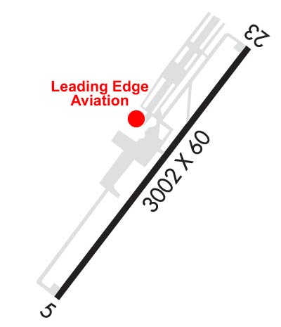
| Lat: N 4020.0 Long: W 07507.3 Elev: 394 Var: +12 Longest Runway: 3002 | ||
| Clr Del: 118.55 AWOS: 118.87 CTAF: 122.97 | ||
| ||||||||||||||||||||||||||||||||||||||||||||||||||||||||||||||||||||
| ||||||||||||||||||||||||||||||||||||||||||||||||||||||||||||||||||||
| ||||||||||||||||||||||||||||||||||||||||||||||||||||||||||||||||||||
| Rwy | Rwy | |||||||
| 3002x60 | 3002' | 3002x60 | 3002' | |||||
| Runway ID | Single Wheel | Double Wheel | Double Tandem Wheel | Dual Double Wheel |
| 05/23 | 12,000 | N/A | N/A | N/A |
| These numbers are Advisory and are not limits. The Airport Manager should have more accurate Weight Limits | ||||
 Airport Diagram might not be current. | |
| Facility Name: | DOYLESTOWN |
| City Name: | DOYLESTOWN |
| County: | BUCKS |
| State abbrev: | PA |
| State Name: | PENNSYLVANIA |
| Ownership: | PUBLICLY OWNED |
| Use: | OPEN TO THE PUBLIC |
| Owner's Name: | BUCKS COUNTY AIRPORT AUTH |
| Address: | BOX 1185 |
| DOYLESTOWN, PA 18902 | |
| Owner's Phone: | 215-345-1970 |
| Manager's Name: | MARCEL BISSCHOPS |
| Address: | 3879 OLD EASTON RD |
| DOYLESTOWN, PA 18902 | |
| Phone: | 215-340-0707 |
| FAA Region: | EASTERN |
| FAA Field Office: | HAR |
| Date | Sunrise | Sunset |
|---|---|---|
| 02/10/25 Monday | 7:00 | 17:30 |
| 02/11/25 Tuesday | 6:59 | 17:31 |
| 02/12/25 Wednesday | 6:58 | 17:32 |
| 02/13/25 Thursday | 6:57 | 17:33 |
| 02/14/25 Friday | 6:56 | 17:35 |
| 02/15/25 Saturday | 6:54 | 17:36 |
| 02/16/25 Sunday | 6:53 | 17:37 |
| 02/17/25 Monday | 6:52 | 17:38 |
| 02/18/25 Tuesday | 6:50 | 17:39 |
| 02/19/25 Wednesday | 6:49 | 17:40 |
| 02/20/25 Thursday | 6:48 | 17:42 |
| 02/21/25 Friday | 6:46 | 17:43 |
| 02/22/25 Saturday | 6:45 | 17:44 |
| 02/23/25 Sunday | 6:43 | 17:45 |
| Airport Attendance Schedule | 7 Days A Week 0700-DUSK; NO SERVICES AVBL CHRISTMAS, NEW YEARS, & THANKSGIVING. |
| Airport Status | OPERATIONAL (This Status can change at any time - please check NOTAMS) |
| Airport Lighting Schedule | ACTVT REIL 23; MIRL 05/23 - CTAF. MIRL 05/23 OPR CONSLY-SS-SR. |
| Airport Storage Available | Tie Downs |
| Extra Services Available | Charter, Flight Instruction, Aircraft Rental |
| Wind Indicator | YES - (lighted) |
| Control Tower | NO |
| CTAF Frequency | 122.975 |
| Unicom Frequency | 122.975 |
| Rotating Beacon Color | WG |
| Segmented Circle | YES |
| Landing Fee | NO |
| Airport Inspected | STATE - performed by STATE AERONAUTICAL PERSONNEL |
| Inspection Date | 06/11/2024 |
| Type of Fuel Available | Grade 100LL, JET A (freeze point -40C) |
| Airframe Repair Service | MAJOR |
| Power Plant Repair Service | MAJOR |
| Latitude | N4020.0 |
| Longitude | W07507.3 (ESTIMATED) |
| Arpt Elevation | 393ft (SURVEYED) |
| Magnetic Variation | 12W |
| 2 miles N | of DOYLESTOWN |
| Traffic Pattern Altitude | |
| Sectional Chart | NEW YORK |
| Operations (Reported) | Yearly | Avg. Daily |
|---|---|---|
| General Aviation Transient | 0 | 0 |
| General Aviation Local | 0 | 0 |
| Air Taxi | 0 | 0 |
| Commerical | 0 | 0 |
| Commuter | 0 | 0 |
| Military | 0 | 0 |
| Aircraft based on Field | |
|---|---|
| General Aviation Singles | 0 |
| General Aviation Multi | 0 |
| Jet Aircraft | 0 |
| General Aviation Helicopters | 0 |
| Military Aircraft | 0 |
| Gliders | 0 |
| Ultralights | 0 |
| FSS on field | NO |
| FSS tie-in | WILLIAMSPORT |
| FSS Phone | 1-800-WX-BRIEF |
| Who issues Notams | DYL |
| Notam D service at airport | YES |
| ARTCC Name | NEW YORK |
| Airport Certification | |
| Aircraft Rescue & Firefighting Index | None |
| Airport of Entry | No |
| Custom Landing Rights | No |
| Joint Civil/Military | No |
| Military Landing rights | YES |
| NATIONAL PLAN OF INTEGRATED AIRPORT SYSTEMS (NPIAS) |
| GRANT AGREEMENTS UNDER FAAP/ADAP/AIP |
| ASSURANCES PURSUANT TO TITLE VI, CIVIL RIGHTS ACT OF 1964 |
| NOISE ABATEMENT PROCEDURES IN EFFECT; CTC AMGR 215-340-0707. |
| DEER, GEESE AND OTHER WILDLIFE ON AND INVOF RWY. |
| RY 05 IS USED FOR CROSSWIND & CALM WIND RY. |
| FOR CD CTC PHILADELPHIA APCH AT 800-354-9884. |
Airport Communications & Frequencies:
| |||||||||||||||||||
| Runway: 05 | Runway: 23 | ||
| Mag heading: | 49° | Mag heading: | 229° |
| Rwy Slope: | .07% Up | Rwy Slope: | -.07% Down |
| Approach: | Approach: | ||
| Pattern: | Left Traffic | Pattern: | Left Traffic |
| Markings: | NONPRECISION INSTRUMENT | Markings: | NONPRECISION INSTRUMENT |
| Marking Condition: | GOOD | Marking Condition: | GOOD |
| Arresting Dev: | Arresting Dev: | ||
| Lat & Long: | N4019.8 W07507.5 | Lat. & Long.: | N4020.2 W07507.1 |
| Elev: | 391.7 ft. MSL | Elev: | 393.7 ft. MSL |
| TCH: | TCH: | 20 ft. AGL | |
| Visual Glide Path: | 5.00 degrees | Visual Glide Path: | 3.00 degrees |
| Displaced Threshold: | No | Displaced Threshold: | No |
| Touchdown Zone: | YES | Touchdown Zone: | YES |
| Touchdown Elev.: | 393.6 feet | Touchdown Elev.: | 393.7 feet |
| Visual Glide Slope: | 2-BOX SIMPLIFIED ABBREVIATED VISUAL APPROACH SLOPE INDICATOR ON LEFT SIDE OF RUNWAY | Visual Glide Slope: | 2-Light PAPI on LEFT side of Runway |
| RVR Equipment: | RVR Equipment: | ||
| RVV Equipment: | NO | RVV Equipment: | NO |
| Approach Lights: | Approach Lights: | ||
| REIL: | NO | REIL: | YES |
| Centerline Lights: | NO | Centerline Lights: | NO |
| Touchdown lights: | NO | Touchdown lights: | NO |
| Runway Category: | Runway with a Non-precision Approach | Runway Category: | Runway with a Non-precision Approach |
| Declared Distances: | Declared Distances: | ||
| Obstructions: | TREES | Obstructions: | TREES |
| Marked: | NOT Marked/Lighted | Marked: | NOT Marked/Lighted |
| Clearance slope: | 14:1 | Clearance slope: | 15:1 |
| Obstruction height: | 39 feet AGL | Obstruction height: | 64 feet AGL |
| Dist. from runway: | 772 feet | Dist. from runway: | 1162 feet |
| Centerline offset: | 281 right of centerline | Centerline offset: | 355 feet left of centerline |
| Comments: | Comments: |
Thanks for using FltPlan.com
all rights reserved © 1999-2025 by Flight Plan LLC