
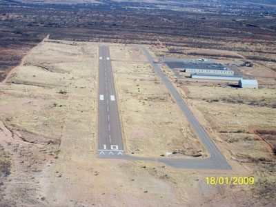
| BENSON MUNI BENSON AZ |
| |
| Lat: N 3200.0 Long: W 11021.5 Elev: 3831 Var: -12 Longest Runway: 4002 | ||
| AWOS: 118.47 CTAF: 122.8 | ||
| ||||||
| ||||||
|
| Rwy | Rwy | |||||||
| 4002x75 | 4002' | 4002x75 | 4002' | |||||
| Runway ID | Single Wheel | Double Wheel | Double Tandem Wheel | Dual Double Wheel |
| 10/28 | 12,500 | N/A | N/A | N/A |
| These numbers are Advisory and are not limits. The Airport Manager should have more accurate Weight Limits | ||||
| FltPlan does not have IFR approach charts available for KE95. |
| Facility Name: | BENSON MUNI |
| City Name: | BENSON |
| County: | COCHISE |
| State abbrev: | AZ |
| State Name: | ARIZONA |
| Ownership: | PUBLICLY OWNED |
| Use: | OPEN TO THE PUBLIC |
| Owner's Name: | CITY OF BENSON |
| Address: | P.O BOX 2223 |
| BENSON, AZ 85602 | |
| Owner's Phone: | 520-586-2245 |
| Manager's Name: | BRAD HAMILTON |
| Address: | P.O BOX 2223 |
| BENSON, AZ 85602 | |
| Phone: | 520-586-2245 |
| FAA Region: | WESTERN-PACIFIC |
| FAA Field Office: | PHX |
| Date | Sunrise | Sunset |
|---|---|---|
| 09/24/21 Friday | 6:11 | 18:16 |
| 09/25/21 Saturday | 6:11 | 18:14 |
| 09/26/21 Sunday | 6:12 | 18:13 |
| 09/27/21 Monday | 6:13 | 18:12 |
| 09/28/21 Tuesday | 6:13 | 18:10 |
| 09/29/21 Wednesday | 6:14 | 18:09 |
| 09/30/21 Thursday | 6:15 | 18:08 |
| 10/01/21 Friday | 6:15 | 18:06 |
| 10/02/21 Saturday | 6:16 | 18:05 |
| 10/03/21 Sunday | 6:17 | 18:04 |
| 10/04/21 Monday | 6:17 | 18:03 |
| 10/05/21 Tuesday | 6:18 | 18:01 |
| 10/06/21 Wednesday | 6:19 | 18:00 |
| 10/07/21 Thursday | 6:19 | 17:59 |
| Airport Attendance Schedule | CONTINUOUS |
| Airport Status | OPERATIONAL (This Status can change at any time - please check NOTAMS) |
| Airport Lighting Schedule | ACTVT PAPI RWY 10 & 28; MIRL RWY 10/28 - CTAF. |
| Airport Storage Available | Tie Downs |
| Extra Services Available | Flight Instruction, Aircraft Rental |
| Wind Indicator | YES - (lighted) |
| Control Tower | NO |
| CTAF Frequency | 122.800 |
| Unicom Frequency | 122.800 |
| Rotating Beacon Color | CLEAR-GREEN (Light Land Airport) |
| Segmented Circle | YES |
| Landing Fee |
| Airport Inspected | STATE - performed by PRIVATE CONTRACT PERSONNEL |
| Inspection Date | 03/29/2020 |
| Type of Fuel Available | Grade 100LL, JET A (freeze point -40C) |
| Airframe Repair Service | MAJOR |
| Power Plant Repair Service | MAJOR |
| Latitude | N3200.0 |
| Longitude | W11021.5 (ESTIMATED) |
| Arpt Elevation | 3830ft (SURVEYED) |
| Magnetic Variation | 12E |
| 3 miles NW | of BENSON |
| Traffic Pattern Altitude | |
| Sectional Chart | PHOENIX |
| Operations (Reported) | Yearly | Avg. Daily |
|---|---|---|
| General Aviation Transient | 15000 | 41 |
| General Aviation Local | 9000 | 25 |
| Air Taxi | 0 | 0 |
| Commerical | 0 | 0 |
| Commuter | 0 | 0 |
| Military | 400 | 1 |
| Aircraft based on Field | |
|---|---|
| General Aviation Singles | 15 |
| General Aviation Multi | 0 |
| Jet Aircraft | 0 |
| General Aviation Helicopters | 1 |
| Military Aircraft | 0 |
| Gliders | 0 |
| Ultralights | 2 |
| FSS on field | NO |
| FSS tie-in | PRESCOTT |
| FSS Phone | 1-800-WX-BRIEF |
| Who issues Notams | PRC |
| Notam D service at airport | YES |
| ARTCC Name | ALBUQUERQUE |
| Airport Certification | |
| Aircraft Rescue & Firefighting Index | None |
| Airport of Entry | No |
| Custom Landing Rights | No |
| Joint Civil/Military | No |
| Military Landing rights | No |
| NATIONAL PLAN OF INTEGRATED AIRPORT SYSTEMS (NPIAS) |
| GRANT AGREEMENTS UNDER FAAP/ADAP/AIP |
| ASSURANCES PURSUANT TO TITLE VI, CIVIL RIGHTS ACT OF 1964 |
| RY 10 HAS FOUR 15 FT DITCHES BOTH SIDES OF RY ENDS & WEST HALF OF RY WITH HEADWALLS 130 FT SOUTH OF CENTERLINE. |
| RY 10, 110 FT TWY EXTENDS FM RY THRESHOLD TO WEST. |
| LIVESTOCK ON OR INVOF AIRPORT. |
| ERRATIC WIND CURRENTS .5 NM FM THRESHOLD WHEN WINDS ARE IN EXCESS OF 10 KTS. |
| FOR CD CTC TUCSON APCH AT 520-829-6121. |
| Runway: 10 | Runway: 28 | ||
| Mag heading: | 89° | Mag heading: | 269° |
| Rwy Slope: | -.68% Down | Rwy Slope: | .68% Up |
| Approach: | Approach: | ||
| Pattern: | Left Traffic | Pattern: | Left Traffic |
| Markings: | BASIC | Markings: | BASIC |
| Marking Condition: | GOOD | Marking Condition: | GOOD |
| Arresting Dev: | Arresting Dev: | ||
| Lat & Long: | N3200.0 W11021.9 | Lat. & Long.: | N3159.9 W11021.1 |
| Elev: | 3830.9 ft. MSL | Elev: | 3803.8 ft. MSL |
| TCH: | 40 ft. AGL | TCH: | 40 ft. AGL |
| Visual Glide Path: | 3.00 degrees | Visual Glide Path: | 3.00 degrees |
| Displaced Threshold: | No | Displaced Threshold: | No |
| Touchdown Zone: | YES | Touchdown Zone: | YES |
| Touchdown Elev.: | 3830.9 feet | Touchdown Elev.: | 3824.2 feet |
| Visual Glide Slope: | 2-Light PAPI on LEFT side of Runway | Visual Glide Slope: | 2-Light PAPI on LEFT side of Runway |
| RVR Equipment: | RVR Equipment: | ||
| RVV Equipment: | NO | RVV Equipment: | NO |
| Approach Lights: | Approach Lights: | ||
| REIL: | YES | REIL: | YES |
| Centerline Lights: | NO | Centerline Lights: | NO |
| Touchdown lights: | NO | Touchdown lights: | NO |
| Runway Category: | Runway with a Visual Approach | Runway Category: | Runway with a Visual Approach |
| Declared Distances: | Declared Distances: | ||
| Obstructions: | BRUSH | Obstructions: | |
| Marked: | NOT Marked/Lighted | Marked: | |
| Clearance slope: | 10:1 | Clearance slope: | 20:1 |
| Obstruction height: | 2 feet AGL | Obstruction height: | |
| Dist. from runway: | 220 feet | Dist. from runway: | |
| Centerline offset: | 84 left of centerline | Centerline offset: | |
| Comments: | RWY 10 3-6 FT BRUSH 125-200 FT FM THLD, 100-125 FT RIGHT OF CNTRLN. | Comments: | RWY 28 +4-6 FT BRUSH 0-50 FT FM THLD, 120-125 FT RIGHT OF CNTRLN; +4 FT BRUSH 130 FT FM THLD, 30 FT LEFT OF CNTRLN. |
Thanks for using FltPlan.com
all rights reserved © 1999-2021 by Flight Plan LLC