
| ELY ARPT /YELLAND FLD ELY NV |
| |
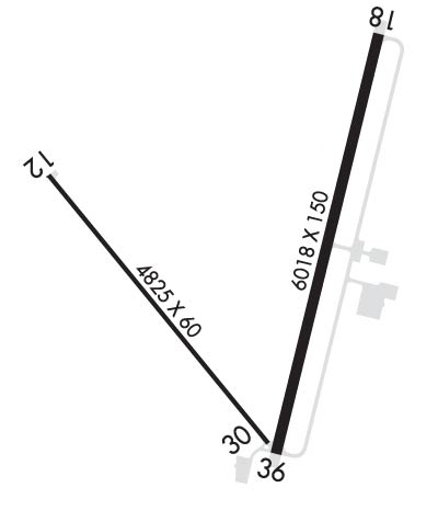
| Lat: N 3918.0 Long: W 11450.5 Elev: 6260 Var: -14 Longest Runway: 6017 | ||
| AWOS: 120.62 CTAF: 122.8 | ||
| ||||||
| ||||||
|
| Rwy | Rwy | |||||||
| 4825x60 | 4825' | 4825x60 | 4825' | |||||
| 6017x150 | 6017' | 6017x150 | 6017' | |||||
| Runway ID | Single Wheel | Double Wheel | Double Tandem Wheel | Dual Double Wheel |
| 12/30 | 15,000 | N/A | N/A | N/A |
| 18/36 | 70,000 | 85,000 | 130,000 | N/A |
| These numbers are Advisory and are not limits. The Airport Manager should have more accurate Weight Limits | ||||
 Airport Diagram might not be current. | |
| Facility Name: | ELY/YELLAND FLD |
| City Name: | ELY |
| County: | WHITE PINE |
| State abbrev: | NV |
| State Name: | NEVADA |
| Ownership: | PUBLICLY OWNED |
| Use: | OPEN TO THE PUBLIC |
| Owner's Name: | WHITE PINE COUNTY |
| Address: | 801 CLARK ST. |
| ELY, NV 89301 | |
| Owner's Phone: | 775-293-6509 |
| Manager's Name: | MARK HOLLOWAY; 775-293-0472 |
| Address: | 1472 MCGILL HIGHWAY |
| ELY, NV 89315-0437 | |
| Phone: | 775-293-2561 |
| FAA Region: | WESTERN-PACIFIC |
| FAA Field Office: | PHX |
| Date | Sunrise | Sunset |
|---|---|---|
| 09/24/21 Friday | 6:29 | 18:33 |
| 09/25/21 Saturday | 6:30 | 18:32 |
| 09/26/21 Sunday | 6:31 | 18:30 |
| 09/27/21 Monday | 6:31 | 18:29 |
| 09/28/21 Tuesday | 6:32 | 18:27 |
| 09/29/21 Wednesday | 6:33 | 18:25 |
| 09/30/21 Thursday | 6:34 | 18:24 |
| 10/01/21 Friday | 6:35 | 18:22 |
| 10/02/21 Saturday | 6:36 | 18:21 |
| 10/03/21 Sunday | 6:37 | 18:19 |
| 10/04/21 Monday | 6:38 | 18:17 |
| 10/05/21 Tuesday | 6:39 | 18:16 |
| 10/06/21 Wednesday | 6:40 | 18:14 |
| 10/07/21 Thursday | 6:41 | 18:13 |
| Airport Attendance Schedule | MON-SAT 0800-1700 |
| Airport Status | OPERATIONAL (This Status can change at any time - please check NOTAMS) |
| Airport Lighting Schedule | ACTVT REIL RWY 18 & 36; PAPI RWY 12, 18 & 36; HIRL RWY 18/36; MIRL RWY 12/30 - CTAF. |
| Airport Storage Available | Tie Downs, Hanger |
| Extra Services Available | Air Freight, Air Ambulance, Cargo Handling, Charter, Glider, Flight Instruction, Glider Towing |
| Wind Indicator | YES - (lighted) |
| Control Tower | NO |
| CTAF Frequency | 122.800 |
| Unicom Frequency | 122.800 |
| Rotating Beacon Color | CLEAR-GREEN (Light Land Airport) |
| Segmented Circle | YES |
| Landing Fee | NO |
| Airport Inspected | FEDERAL - performed by STATE AERONAUTICAL PERSONNEL |
| Inspection Date | 06/24/2020 |
| Type of Fuel Available | Grade 100LL, JET A (freeze point -40C); -10FUEL AVBL AFT HRS. |
| Airframe Repair Service | NONE |
| Power Plant Repair Service | NONE |
| Latitude | N3918.0 |
| Longitude | W11450.5 (ESTIMATED) |
| Arpt Elevation | 6259ft (SURVEYED) |
| Magnetic Variation | 14E |
| 3 miles NE | of ELY |
| Traffic Pattern Altitude | |
| Sectional Chart | LAS VEGAS |
| Operations (Reported) | Yearly | Avg. Daily |
|---|---|---|
| General Aviation Transient | 2160 | 6 |
| General Aviation Local | 1080 | 3 |
| Air Taxi | 1260 | 3 |
| Commerical | 0 | 0 |
| Commuter | 0 | 0 |
| Military | 230 | 1 |
| Aircraft based on Field | |
|---|---|
| General Aviation Singles | 9 |
| General Aviation Multi | 1 |
| Jet Aircraft | 0 |
| General Aviation Helicopters | 0 |
| Military Aircraft | 0 |
| Gliders | 0 |
| Ultralights | 0 |
| FSS on field | NO |
| FSS tie-in | RENO |
| FSS Phone | 1-800-WX-BRIEF |
| Who issues Notams | ELY |
| Notam D service at airport | YES |
| ARTCC Name | SALT LAKE CITY |
| Airport Certification | |
| Aircraft Rescue & Firefighting Index | None |
| Airport of Entry | No |
| Custom Landing Rights | No |
| Joint Civil/Military | No |
| Military Landing rights | YES |
| NATIONAL PLAN OF INTEGRATED AIRPORT SYSTEMS (NPIAS) |
| GRANT AGREEMENTS UNDER FAAP/ADAP/AIP |
| CONVEYANCE UNDER SCETION 16, FEDERAL AIRPORT ACT OF 1946 OR SECTION 23, AIRPORT AND AIRWAY DEVELOPMENT ACT OF 1970 |
| ASSURANCES PURSUANT TO TITLE VI, CIVIL RIGHTS ACT OF 1964 |
| ULTRA-LIGHT ACFT OPS ON AND INVOF ARPT DRG DALGT HRS. |
| RWY 12/30 NOT AVBL FOR ACFT OVR 30 PAX SEATS. |
| GLD OPS ON AND INVOF ARPT MAY-SEPT. |
| FOR CD IF UNA TO CTC ON FSS FREQ, CTC SALT LAKE ARTCC AT 801-320-2568. |
| RWY 12/3 0 PAVEMENT CRACKING IN EXCESS OF 3 INCHES AND FROST HEAVING BELOW FREEZING CONDITIONS. |
Airport Communications & Frequencies:
| |||||||||
| Runway: 12 | Runway: 30 | ||
| Mag heading: | 127° | Mag heading: | 307° |
| Rwy Slope: | .40% Up | Rwy Slope: | -.40% Down |
| Approach: | Approach: | ||
| Pattern: | Left Traffic | Pattern: | Left Traffic |
| Markings: | NONPRECISION INSTRUMENT | Markings: | NUMBERS ONLY |
| Marking Condition: | POOR; RWY 12/30 MARKINGS FADED, MAY NOT BE VSB DRG NGT COND. | Marking Condition: | POOR |
| Arresting Dev: | Arresting Dev: | ||
| Lat & Long: | N3918.2 W11451.1 | Lat. & Long.: | N3917.6 W11450.5 |
| Elev: | 6239.5 ft. MSL | Elev: | 6259.0 ft. MSL |
| TCH: | 40 ft. AGL | TCH: | |
| Visual Glide Path: | 3.00 degrees | Visual Glide Path: | |
| Displaced Threshold: | No | Displaced Threshold: | No |
| Touchdown Zone: | YES | Touchdown Zone: | YES |
| Touchdown Elev.: | 6252.8 feet | Touchdown Elev.: | 6259.4 feet |
| Visual Glide Slope: | 4-Light PAPI on RIGHT side of Runway | Visual Glide Slope: | |
| RVR Equipment: | RVR Equipment: | ||
| RVV Equipment: | NO | RVV Equipment: | NO |
| Approach Lights: | Approach Lights: | ||
| REIL: | NO | REIL: | NO |
| Centerline Lights: | NO | Centerline Lights: | NO |
| Touchdown lights: | NO | Touchdown lights: | NO |
| Runway Category: | Runway with a Visual Approach | Runway Category: | Runway with a Visual Approach |
| Declared Distances: | Declared Distances: | ||
| Obstructions: | Obstructions: | POLE | |
| Marked: | Marked: | NOT Marked/Lighted | |
| Clearance slope: | 50:1 | Clearance slope: | 20:1 |
| Obstruction height: | Obstruction height: | 30 feet AGL | |
| Dist. from runway: | Dist. from runway: | 1230 feet | |
| Centerline offset: | Centerline offset: | 10 feet right of centerline | |
| Comments: | Comments: |
| Runway: 18 | Runway: 36 | ||
| Mag heading: | 180° | Mag heading: | 0° |
| Rwy Slope: | .58% Up | Rwy Slope: | -.58% Down |
| Approach: | Approach: | ||
| Pattern: | Left Traffic | Pattern: | Left Traffic |
| Markings: | NONPRECISION INSTRUMENT | Markings: | NONPRECISION INSTRUMENT |
| Marking Condition: | GOOD | Marking Condition: | GOOD |
| Arresting Dev: | Arresting Dev: | ||
| Lat & Long: | N3918.5 W11450.1 | Lat. & Long.: | N3917.6 W11450.4 |
| Elev: | 6225.1 ft. MSL | Elev: | 6259.7 ft. MSL |
| TCH: | 50 ft. AGL | TCH: | 50 ft. AGL |
| Visual Glide Path: | 3.00 degrees | Visual Glide Path: | 3.00 degrees |
| Displaced Threshold: | No | Displaced Threshold: | No |
| Touchdown Zone: | YES | Touchdown Zone: | YES |
| Touchdown Elev.: | 6242.4 feet | Touchdown Elev.: | 6259.7 feet |
| Visual Glide Slope: | 4-Light PAPI on LEFT side of Runway | Visual Glide Slope: | 4-Light PAPI on LEFT side of Runway |
| RVR Equipment: | RVR Equipment: | ||
| RVV Equipment: | NO | RVV Equipment: | NO |
| Approach Lights: | Approach Lights: | ||
| REIL: | YES | REIL: | YES |
| Centerline Lights: | NO | Centerline Lights: | NO |
| Touchdown lights: | NO | Touchdown lights: | NO |
| Runway Category: | Runway with a Non-precision Approach having visibility minimums greater than 3/4 mile | Runway Category: | Runway with a Visual Approach |
| Declared Distances: | Declared Distances: |
Thanks for using FltPlan.com
all rights reserved © 1999-2021 by Flight Plan LLC