
| NEW SMYRNA BEACH MUNI NEW SMYRNA BEACH FL |
| |
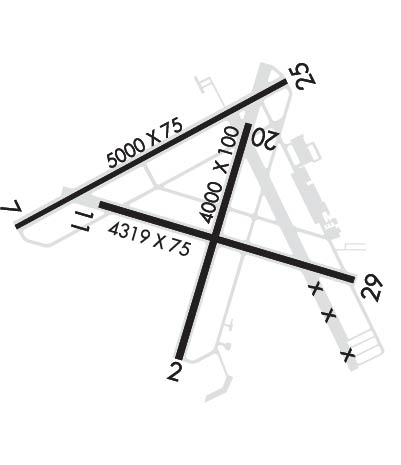
| Lat: N 2903.3 Long: W 08056.9 Elev: 11 Var: +04 Longest Runway: 5000 | ||
| Dept. ATIS: 124.62 Arr. ATIS: 124.62 AWOS: 124.62 Ground: 121.32 Tower: 119.67 | ||
| ||||||||||||||||||||||||||||||||||||||||||||
| ||||||||||||||||||||||||||||||||||||||||||||
| ||||||||||||||||||||||||||||||||||||||||||||
| ||||||||||||||||||||||||||||||||||||||||||||
| ||||||||||||||||||||||||||||||||||||||||||||
| Rwy | Rwy | |||||||
| 4000x100 | 3215' | 4000x100 | 4000' | |||||
| 5000x75 | 4665' | 5000x75 | 4700' | |||||
| 4319x75 | 4319' | 4319x75 | 4319' | |||||
| Runway ID | Single Wheel | Double Wheel | Double Tandem Wheel | Dual Double Wheel |
| 02/20 | 55,000 | N/A | N/A | N/A |
| 07/25 | 55,000 | N/A | N/A | N/A |
| 11/29 | 55,000 | N/A | N/A | N/A |
| These numbers are Advisory and are not limits. The Airport Manager should have more accurate Weight Limits | ||||
 Airport Diagram might not be current. | |
| Facility Name: | NEW SMYRNA BEACH MUNI |
| City Name: | NEW SMYRNA BEACH |
| County: | VOLUSIA |
| State abbrev: | FL |
| State Name: | FLORIDA |
| Ownership: | PUBLICLY OWNED |
| Use: | OPEN TO THE PUBLIC |
| Owner's Name: | CITY OF NEW SMYRNA BEACH |
| Address: | 210 SAMS AVE |
| NEW SMYRNA BEACH, FL 32168 | |
| Owner's Phone: | 386-410-2610 |
| Manager's Name: | ARVIN WEESE |
| Address: | NEW SMYRNA BEACH MUNI AIRPORT, 602 SKYLINE DRIVE |
| NEW SMYRNA BEACH, FL 32168 | |
| Phone: | 386-410-2680 |
| FAA Region: | SOUTHERN |
| FAA Field Office: | ORL |

| Date | Sunrise | Sunset |
|---|---|---|
| 01/03/25 Friday | 7:18 | 17:39 |
| 01/04/25 Saturday | 7:18 | 17:40 |
| 01/05/25 Sunday | 7:18 | 17:40 |
| 01/06/25 Monday | 7:19 | 17:41 |
| 01/07/25 Tuesday | 7:19 | 17:42 |
| 01/08/25 Wednesday | 7:19 | 17:43 |
| 01/09/25 Thursday | 7:19 | 17:43 |
| 01/10/25 Friday | 7:19 | 17:44 |
| 01/11/25 Saturday | 7:19 | 17:45 |
| 01/12/25 Sunday | 7:19 | 17:46 |
| 01/13/25 Monday | 7:19 | 17:47 |
| 01/14/25 Tuesday | 7:19 | 17:47 |
| 01/15/25 Wednesday | 7:19 | 17:48 |
| 01/16/25 Thursday | 7:19 | 17:49 |
| Airport Attendance Schedule | 7 Days A Week 0700-2200 |
| Airport Status | OPERATIONAL (This Status can change at any time - please check NOTAMS) |
| Airport Lighting Schedule | ACTVT MIRL RWY 11/29 & 07/25 AFTER 2300 - CTAF. |
| Airport Storage Available | Tie Downs, Hanger |
| Extra Services Available | Avionics, Charter, Flight Instruction, Aircraft Rental, Aircraft Sales |
| Wind Indicator | YES - (lighted) |
| Control Tower | YES |
| CTAF Frequency | 119.675 |
| Unicom Frequency | 122.950 |
| Rotating Beacon Color | WG |
| Segmented Circle | Y-L |
| Landing Fee | NO |
| Airport Inspected | STATE - performed by STATE AERONAUTICAL PERSONNEL |
| Inspection Date | 08/20/2024 |
| Type of Fuel Available | Grade 100LL, JET A (freeze point -40C); -A INCLS ANTI-ICING ADDITIVE. |
| Airframe Repair Service | MAJOR |
| Power Plant Repair Service | MAJOR |
| Latitude | N2903.3 |
| Longitude | W08056.9 (ESTIMATED) |
| Arpt Elevation | 10ft (SURVEYED) |
| Magnetic Variation | 04W |
| 3 miles NW | of NEW SMYRNA BEACH |
| Traffic Pattern Altitude | 788; TPA FOR LGT ACFT 788 FT AGL, HVY ACFT 1188 FT AGL. |
| Sectional Chart | JACKSONVILLE |
| Operations (Reported) | Yearly | Avg. Daily |
|---|---|---|
| General Aviation Transient | 0 | 0 |
| General Aviation Local | 0 | 0 |
| Air Taxi | 0 | 0 |
| Commerical | 0 | 0 |
| Commuter | 0 | 0 |
| Military | 0 | 0 |
| Aircraft based on Field | |
|---|---|
| General Aviation Singles | 0 |
| General Aviation Multi | 0 |
| Jet Aircraft | 0 |
| General Aviation Helicopters | 0 |
| Military Aircraft | 0 |
| Gliders | 0 |
| Ultralights | 0 |
| FSS on field | NO |
| FSS tie-in | SAINT PETERSBURG |
| FSS Phone | 1-800-WX-BRIEF |
| Who issues Notams | EVB |
| Notam D service at airport | YES |
| ARTCC Name | JACKSONVILLE |
| Airport Certification | |
| Aircraft Rescue & Firefighting Index | None |
| Airport of Entry | No |
| Custom Landing Rights | No |
| Joint Civil/Military | No |
| Military Landing rights | YES |
| NATIONAL PLAN OF INTEGRATED AIRPORT SYSTEMS (NPIAS) |
| GRANT AGREEMENTS UNDER FAAP/ADAP/AIP |
| SURPLUS PROPERTY AGREEMENT UNDER REGULATION 16-WAA |
| ASSURANCES PURSUANT TO TITLE VI, CIVIL RIGHTS ACT OF 1964 |
| AGREEMENT UNDER DLAND OR DCLA HAS EXPIRED. |
| FOR CD OR TO CNL IFR WHEN ATCT IS CLSD CTC DAB APCH AT 386-226-3939. |
| UNLGTD OBSTRUCTIONS ROAD & FENCE 200 FT BFR AER 25, 250 FT RIGHT OF CENTERLINE. |
| UNLGTD OBSTNS ROAD & FENCE 83 FT BFR AER 07, 250 FT RIGHT OF CNTRLN. |
| ALL HELO OPS EXPC FULL SVC FUEL ONLY, SELF SVC CLSD TO ALL ROTARY WING ACFT. |
| RWY 02/20 AND TWY CRACKING WITH GRASS. |
| VOLUNTARY NOISE ABATEMENT IN EFCT, CTC ARPT MGR FOR DETAILS AT 386-410-2680. |
| BIRDS ON & INVOF ARPT. |
| ARPT CLSD FOR ULTRALIGHTS, EXC PPR 386-410-2680. |
| RWY 02/2 0 RWY 02/20 LONGL & TRANSVERSE CRACKING THRUT. |
Airport Communications & Frequencies:
| ||||||||||||||||||||
| Runway: 02 | Runway: 20 | ||
| Mag heading: | 21° | Mag heading: | 201° |
| Rwy Slope: | .02% Up | Rwy Slope: | -.02% Down |
| Approach: | Approach: | ||
| Pattern: | Left Traffic | Pattern: | Left Traffic |
| Markings: | BASIC | Markings: | BASIC |
| Marking Condition: | GOOD | Marking Condition: | GOOD |
| Arresting Dev: | Arresting Dev: | ||
| Lat & Long: | N2902.9 W08057.0 | Lat. & Long.: | N2903.6 W08056.8 |
| Elev: | 8.1 ft. MSL | Elev: | 8.8 ft. MSL |
| TCH: | TCH: | ||
| Visual Glide Path: | Visual Glide Path: | ||
| Displaced Threshold: | 785 feet | Displaced Threshold: | No |
| Touchdown Zone: | YES | Touchdown Zone: | YES |
| Touchdown Elev.: | 8.8 feet | Touchdown Elev.: | 8.8 feet |
| Visual Glide Slope: | Visual Glide Slope: | ||
| RVR Equipment: | RVR Equipment: | ||
| RVV Equipment: | NO | RVV Equipment: | NO |
| Approach Lights: | Approach Lights: | ||
| REIL: | NO | REIL: | NO |
| Centerline Lights: | NO | Centerline Lights: | NO |
| Touchdown lights: | NO | Touchdown lights: | NO |
| Runway Category: | Runway with a Non-precision Approach having visibility minimums greater than 3/4 mile | Runway Category: | Runway with a Visual Approach |
| Declared Distances: | TORA:4000' TODA:4000' ASDA:4000' LDA:3215' | Declared Distances: | TORA:4000' TODA:4000' ASDA:3952' LDA:3952' |
| Obstructions: | ROAD | Obstructions: | TREES |
| Marked: | NOT Marked/Lighted | Marked: | NOT Marked/Lighted |
| Clearance slope: | 5:1; RWY 02 APCH RATIO 34:1 TO DSPLCD THR. | Clearance slope: | 21:1 |
| Obstruction height: | 16 feet AGL | Obstruction height: | 55 feet AGL |
| Dist. from runway: | 295 feet | Dist. from runway: | 1390 feet |
| Centerline offset: | 250 left of centerline | Centerline offset: | 250 feet right of centerline |
| Comments: | Comments: |
| Runway: 07 | Runway: 25 | ||
| Mag heading: | 66° | Mag heading: | 246° |
| Rwy Slope: | .05% Up | Rwy Slope: | -.05% Down |
| Approach: | Approach: | ||
| Pattern: | Left Traffic | Pattern: | Left Traffic |
| Markings: | NONPRECISION INSTRUMENT | Markings: | NONPRECISION INSTRUMENT |
| Marking Condition: | FAIR | Marking Condition: | FAIR |
| Arresting Dev: | Arresting Dev: | ||
| Lat & Long: | N2903.3 W08057.5 | Lat. & Long.: | N2903.7 W08056.7 |
| Elev: | 7.5 ft. MSL | Elev: | 9.8 ft. MSL |
| TCH: | 48 ft. AGL | TCH: | 46 ft. AGL |
| Visual Glide Path: | 3.00 degrees | Visual Glide Path: | 3.00 degrees |
| Displaced Threshold: | 335 feet | Displaced Threshold: | 300 feet |
| Touchdown Zone: | YES | Touchdown Zone: | YES |
| Touchdown Elev.: | 8.6 feet | Touchdown Elev.: | 10.1 feet |
| Visual Glide Slope: | 4-Light PAPI on LEFT side of Runway | Visual Glide Slope: | 4-Light PAPI on LEFT side of Runway |
| RVR Equipment: | RVR Equipment: | ||
| RVV Equipment: | NO | RVV Equipment: | NO |
| Approach Lights: | Approach Lights: | ||
| REIL: | NO | REIL: | NO |
| Centerline Lights: | NO | Centerline Lights: | NO |
| Touchdown lights: | NO | Touchdown lights: | NO |
| Runway Category: | Runway with a Non-precision Approach having visibility minimums greater than 3/4 mile | Runway Category: | Runway with a Non-precision Approach having visibility minimums greater than 3/4 mile |
| Declared Distances: | TORA:5000' TODA:5000' ASDA:4853' LDA:4518' | Declared Distances: | TORA:5000' TODA:5000' ASDA:4763' LDA:4463' |
| Obstructions: | FENCE | Obstructions: | FENCE |
| Marked: | NOT Marked/Lighted | Marked: | NOT Marked/Lighted |
| Clearance slope: | RWY 07 APCH RATIO 34:1 TO DSPLCD THR. | Clearance slope: | RWY 25 APCH RATIO 34:1 TO DSPLCD THR. |
| Obstruction height: | 6 feet AGL | Obstruction height: | 6 feet AGL |
| Dist. from runway: | 56 feet | Dist. from runway: | 161 feet |
| Centerline offset: | 250 right of centerline | Centerline offset: | 250 feet right of centerline |
| Comments: | RWY 07 15 FT ROAD 83 FT FM AER, 250 FT R. | Comments: | RWY 25 15 FT ROAD 200 FT FM RWY END 250 FT RIGHT OF CNTRLN. |
| Runway: 11 | Runway: 29 | ||
| Mag heading: | 111° | Mag heading: | 291° |
| Rwy Slope: | .06% Up | Rwy Slope: | -.06% Down |
| Approach: | Approach: | ||
| Pattern: | Left Traffic | Pattern: | Left Traffic |
| Markings: | NONPRECISION INSTRUMENT | Markings: | NONPRECISION INSTRUMENT |
| Marking Condition: | FAIR | Marking Condition: | FAIR |
| Arresting Dev: | Arresting Dev: | ||
| Lat & Long: | N2903.4 W08057.2 | Lat. & Long.: | N2903.2 W08056.4 |
| Elev: | 7.8 ft. MSL | Elev: | 10.4 ft. MSL |
| TCH: | 39 ft. AGL | TCH: | 35 ft. AGL |
| Visual Glide Path: | 3.50 degrees | Visual Glide Path: | 3.00 degrees |
| Displaced Threshold: | No | Displaced Threshold: | No |
| Touchdown Zone: | YES | Touchdown Zone: | YES |
| Touchdown Elev.: | 10.5 feet | Touchdown Elev.: | 10.8 feet |
| Visual Glide Slope: | 4-Light PAPI on LEFT side of Runway | Visual Glide Slope: | 4-Light PAPI on LEFT side of Runway |
| RVR Equipment: | RVR Equipment: | ||
| RVV Equipment: | NO | RVV Equipment: | NO |
| Approach Lights: | Approach Lights: | ||
| REIL: | NO | REIL: | NO |
| Centerline Lights: | NO | Centerline Lights: | NO |
| Touchdown lights: | NO | Touchdown lights: | NO |
| Runway Category: | Runway with a Visual Approach | Runway Category: | Runway with a Non-precision Approach having visibility minimums greater than 3/4 mile |
| Declared Distances: | Declared Distances: | ||
| Obstructions: | TREES | Obstructions: | ROAD |
| Marked: | NOT Marked/Lighted | Marked: | NOT Marked/Lighted |
| Clearance slope: | 20:1 | Clearance slope: | 21:1 |
| Obstruction height: | 78 feet AGL | Obstruction height: | 15 feet AGL |
| Dist. from runway: | 1780 feet | Dist. from runway: | 537 feet |
| Centerline offset: | 200 right of centerline | Centerline offset: | 250 feet right of centerline |
| Comments: | Comments: |
Thanks for using FltPlan.com
all rights reserved © 1999-2025 by Flight Plan LLC