| LINCOLNTON-LINCOLN COUNTY RGNL LINCOLNTON NC |
| |
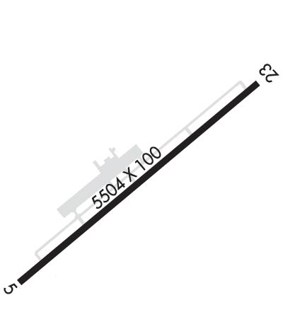
| Lat: N 3529.0 Long: W 08109.7 Elev: 878 Var: +06 Longest Runway: 5700 | ||
| Clr Del: 124.9 AWOS: 119.67 CTAF: 123.05 | ||
| ||||||||||||||||||||||||||||||
| ||||||||||||||||||||||||||||||
| ||||||||||||||||||||||||||||||
| Rwy | Rwy | |||||||
| 5700x100 | 5500' | 5700x100 | 5501' | 111.15 - 233° | ||||
| Runway ID | Single Wheel | Double Wheel | Double Tandem Wheel | Dual Double Wheel |
| 05/23 | 30,000 | 60,000 | N/A | N/A |
| These numbers are Advisory and are not limits. The Airport Manager should have more accurate Weight Limits | ||||
 Airport Diagram might not be current. | |
| Facility Name: | LINCOLNTON-LINCOLN COUNTY RGNL |
| City Name: | LINCOLNTON |
| County: | LINCOLN |
| State abbrev: | NC |
| State Name: | NORTH CAROLINA |
| Ownership: | PUBLICLY OWNED |
| Use: | OPEN TO THE PUBLIC |
| Owner's Name: | CITY OF LINCOLNTON & LINCOLN |
| Address: | 714 JACK DELLINGER DRIVE |
| IRON STATION, NC 28080 | |
| Owner's Phone: | 704-736-8488 |
| Manager's Name: | JOE TATE |
| Address: | 714 JACK DELLINGER DRIVE |
| IRON STATION, NC 28080 | |
| Phone: | 704-735-0602 |
| FAA Region: | SOUTHERN |
| FAA Field Office: | MEM |
| Date | Sunrise | Sunset |
|---|---|---|
| 09/24/21 Friday | 7:14 | 19:19 |
| 09/25/21 Saturday | 7:15 | 19:17 |
| 09/26/21 Sunday | 7:15 | 19:16 |
| 09/27/21 Monday | 7:16 | 19:15 |
| 09/28/21 Tuesday | 7:17 | 19:13 |
| 09/29/21 Wednesday | 7:18 | 19:12 |
| 09/30/21 Thursday | 7:19 | 19:10 |
| 10/01/21 Friday | 7:19 | 19:09 |
| 10/02/21 Saturday | 7:20 | 19:07 |
| 10/03/21 Sunday | 7:21 | 19:06 |
| 10/04/21 Monday | 7:22 | 19:05 |
| 10/05/21 Tuesday | 7:23 | 19:03 |
| 10/06/21 Wednesday | 7:23 | 19:02 |
| 10/07/21 Thursday | 7:24 | 19:00 |
| Airport Attendance Schedule | APR-OCT 7 Days A Week 0800-1900, NOV-MAR 7 Days A Week 0800-1800; UNATTENDED THANKSGIVING AND CHRISTMAS DAY |
| Airport Status | OPERATIONAL (This Status can change at any time - please check NOTAMS) |
| Airport Lighting Schedule | MIRL RY 05/23 PRESET LOW INTST; TO INCR INTST & ACTVT REIL RYS 05 & 23 AND PAPI RYS 05 & 23 - CTAF. |
| Airport Storage Available | Tie Downs |
| Extra Services Available | Flight Instruction, Aircraft Rental, Aircraft Sales |
| Wind Indicator | YES - (lighted) |
| Control Tower | NO |
| CTAF Frequency | 123.050 |
| Unicom Frequency | 123.050 |
| Rotating Beacon Color | CLEAR-GREEN (Light Land Airport) |
| Segmented Circle | YES |
| Landing Fee | NO |
| Airport Inspected | STATE - performed by STATE AERONAUTICAL PERSONNEL |
| Inspection Date | 05/11/2018 |
| Type of Fuel Available | Grade 100LL, JET A-1 (icing inhibitor, freeze point -50C) |
| Airframe Repair Service | MAJOR |
| Power Plant Repair Service | MAJOR |
| Latitude | N3529.0 |
| Longitude | W08109.7 (ESTIMATED) |
| Arpt Elevation | 877ft (SURVEYED) |
| Magnetic Variation | 06W |
| 5 miles E | of LINCOLNTON |
| Traffic Pattern Altitude | |
| Sectional Chart | CHARLOTTE |
| Operations (Reported) | Yearly | Avg. Daily |
|---|---|---|
| General Aviation Transient | 17900 | 49 |
| General Aviation Local | 15300 | 42 |
| Air Taxi | 0 | 0 |
| Commerical | 0 | 0 |
| Commuter | 0 | 0 |
| Military | 900 | 2 |
| Aircraft based on Field | |
|---|---|
| General Aviation Singles | 65 |
| General Aviation Multi | 11 |
| Jet Aircraft | 2 |
| General Aviation Helicopters | 2 |
| Military Aircraft | 0 |
| Gliders | 0 |
| Ultralights | 0 |
| FSS on field | NO |
| FSS tie-in | RALEIGH |
| FSS Phone | 1-800-WX-BRIEF |
| Who issues Notams | IPJ |
| Notam D service at airport | YES |
| ARTCC Name | ATLANTA |
| Airport Certification | |
| Aircraft Rescue & Firefighting Index | None |
| Airport of Entry | No |
| Custom Landing Rights | No |
| Joint Civil/Military | No |
| Military Landing rights | No |
| NATIONAL PLAN OF INTEGRATED AIRPORT SYSTEMS (NPIAS) |
| GRANT AGREEMENTS UNDER FAAP/ADAP/AIP |
| ASSURANCES PURSUANT TO TITLE VI, CIVIL RIGHTS ACT OF 1964 |
| RY 23 HAS A 90 FT DROP OFF 100 FT FM PAVEMENT. |
| GCO AVBL ON FREQ 124.900 THRU CLT CLEARANCE DELIVERY. |
| FOR CD IF UNA VIA GCO CTC CHARLOTTE APCH AT 704-359-0241. |
| GCO AVBL ON FREQ 124.900 THRU CHARLOTTE APCH; KEY MIKE 4 TIMES SLOWLY, WAIT FOR DIAL TONE AND RING. |
| ARPT PHONE NR 704-735-0602. |
| DEER, COYOTE & BIRDS ON & INVOF ARPT. |
| RWY 05/2 3 200 FT SWY SW END HAS BEEN REMARKED AS 200 FT DSPLCD THLD FOR RWY 5. |
Airport Communications & Frequencies:
| ||||||||||||||||
| Runway: 05 | Runway: 23 | ||
| Mag heading: | 53° | Mag heading: | 233° |
| Rwy Slope: | -.26% Down | Rwy Slope: | .26% Up |
| Approach: | Approach: | ILS/DME | |
| Pattern: | Left Traffic | Pattern: | Left Traffic |
| Markings: | NONPRECISION INSTRUMENT | Markings: | PRECISION INSTRUMENT |
| Marking Condition: | GOOD | Marking Condition: | GOOD |
| Arresting Dev: | Arresting Dev: | ||
| Lat & Long: | N3528.7 W08110.1 | Lat. & Long.: | N3529.3 W08109.3 |
| Elev: | 877.9 ft. MSL | Elev: | 863.1 ft. MSL |
| TCH: | 64 ft. AGL | TCH: | 47 ft. AGL |
| Visual Glide Path: | 3.40 degrees | Visual Glide Path: | 3.00 degrees |
| Displaced Threshold: | 200 feet | Displaced Threshold: | 199 feet |
| Touchdown Zone: | YES | Touchdown Zone: | YES |
| Touchdown Elev.: | 877.9 feet | Touchdown Elev.: | 872.0 feet |
| Visual Glide Slope: | 2-Light PAPI on LEFT side of Runway | Visual Glide Slope: | 2-Light PAPI on LEFT side of Runway |
| RVR Equipment: | RVR Equipment: | ||
| RVV Equipment: | NO | RVV Equipment: | NO |
| Approach Lights: | Approach Lights: | ||
| REIL: | YES | REIL: | YES |
| Centerline Lights: | NO | Centerline Lights: | NO |
| Touchdown lights: | NO | Touchdown lights: | NO |
| Runway Category: | Runway with a Non-precision Approach having visibility minimums greater than 3/4 mile | Runway Category: | Precision Instrument Runway |
| Declared Distances: | Declared Distances: | ||
| Obstructions: | TREES | Obstructions: | TREES |
| Marked: | NOT Marked/Lighted | Marked: | NOT Marked/Lighted |
| Clearance slope: | 15:1; APCH SLOPE 16:1 AT DSPLCD THLD | Clearance slope: | 8:1; APCH SLOPE 26:1 AT DSPLCD THLD DUE TO 41 FT TREES 1287 FM DSPLCD THLD OFFSET 179 FT L OF CNTRLN. |
| Obstruction height: | 145 feet AGL | Obstruction height: | 16 feet AGL |
| Dist. from runway: | 2449 feet | Dist. from runway: | 338 feet |
| Centerline offset: | 485 left of centerline | Centerline offset: | 426 feet right of centerline |
| Comments: | Comments: |
Thanks for using FltPlan.com
all rights reserved © 1999-2021 by Flight Plan LLC