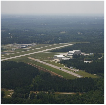
| SOUTH ALABAMA RGNL ANDALUSIA AL |
| |
| Lat: N 3118.5 Long: W 08623.5 Elev: 310 Var: +02 Longest Runway: 6000 | ||
| AWOS: 134.87 CTAF: 123.05 | ||
| ||||||||||||||||||||||||||||||||||||||||||||||||||||||||||||||||||||
| ||||||||||||||||||||||||||||||||||||||||||||||||||||||||||||||||||||
| ||||||||||||||||||||||||||||||||||||||||||||||||||||||||||||||||||||
| Rwy | Rwy | |||||||
| 6000x100 | 6000' | 6000x100 | 6000' | |||||
| Runway ID | Single Wheel | Double Wheel | Double Tandem Wheel | Dual Double Wheel |
| 11/29 | 98,000 | 160,000 | 275,000 | N/A |
| These numbers are Advisory and are not limits. The Airport Manager should have more accurate Weight Limits | ||||
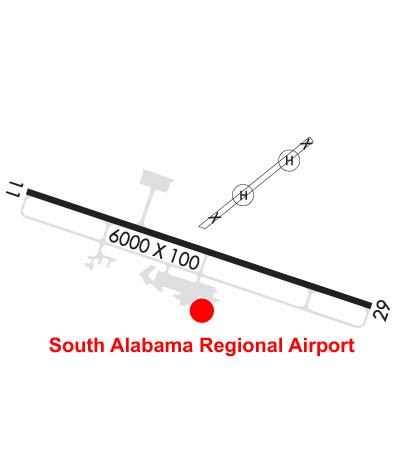 Airport Diagram might not be current. | |
| Facility Name: | SOUTH ALABAMA RGNL AT BILL BENTON FLD |
| City Name: | ANDALUSIA |
| County: | COVINGTON |
| State abbrev: | AL |
| State Name: | ALABAMA |
| Ownership: | PUBLICLY OWNED |
| Use: | OPEN TO THE PUBLIC |
| Owner's Name: | ANDALUSIA ARPT AUTH |
| Address: | 21861 BILL BENTON LANE |
| ANDALUSIA, AL 36421 | |
| Owner's Phone: | 334-222-6598 |
| Manager's Name: | JED BLACKWELL; JED BLACKWELL |
| Address: | 21861 BILL BENTON LANE |
| ANDALUSIA, AL 36421 | |
| Phone: | 334-222-6598 |
| FAA Region: | SOUTHERN |
| FAA Field Office: | JAN |
| Date | Sunrise | Sunset |
|---|---|---|
| 07/13/26 Monday | 5:50 | 19:52 |
| 07/14/26 Tuesday | 5:51 | 19:52 |
| 07/15/26 Wednesday | 5:52 | 19:51 |
| 07/16/26 Thursday | 5:52 | 19:51 |
| 07/17/26 Friday | 5:53 | 19:50 |
| 07/18/26 Saturday | 5:53 | 19:50 |
| 07/19/26 Sunday | 5:54 | 19:49 |
| 07/20/26 Monday | 5:54 | 19:49 |
| 07/21/26 Tuesday | 5:55 | 19:48 |
| 07/22/26 Wednesday | 5:56 | 19:48 |
| 07/23/26 Thursday | 5:56 | 19:47 |
| 07/24/26 Friday | 5:57 | 19:47 |
| 07/25/26 Saturday | 5:58 | 19:46 |
| 07/26/26 Sunday | 5:58 | 19:46 |
| Airport Attendance Schedule | SAT-SUN 0730-1630, MON - FRI 0630-0000; AFT HRS SVC CALL 334-222-0638/334-427-0733 |
| Airport Status | OPERATIONAL (This Status can change at any time - please check NOTAMS) |
| Airport Lighting Schedule | ACTVT PAPI RWY 11 & 29; MIRL RWY 11/29 - CTAF. |
| Airport Storage Available | Tie Downs |
| Extra Services Available | Flight Instruction |
| Wind Indicator | YES - (lighted) |
| Control Tower | NO |
| CTAF Frequency | 123.050 |
| Unicom Frequency | 123.050 |
| Rotating Beacon Color | WG |
| Segmented Circle | YES |
| Landing Fee | NO |
| Airport Inspected | STATE - performed by STATE AERONAUTICAL PERSONNEL |
| Inspection Date | 05/02/2024 |
| Type of Fuel Available | Grade 100LL, JET A; -10100LL SELF SERVE AVBL 24 HRS.; -A+MILITARY CONTRACT FUEL AVBL MON-FRI 0700-2400, OTHER TIMES CALL (334) 222-0638 |
| Airframe Repair Service | MAJOR |
| Power Plant Repair Service | MAJOR |
| Latitude | N3118.5 |
| Longitude | W08623.5 (ESTIMATED) |
| Arpt Elevation | 310ft (SURVEYED) |
| Magnetic Variation | 02W |
| 4 miles E | of ANDALUSIA |
| Traffic Pattern Altitude | |
| Sectional Chart | NEW ORLEANS |
| Operations (Reported) | Yearly | Avg. Daily |
|---|---|---|
| General Aviation Transient | 0 | 0 |
| General Aviation Local | 0 | 0 |
| Air Taxi | 0 | 0 |
| Commerical | 0 | 0 |
| Commuter | 0 | 0 |
| Military | 0 | 0 |
| Aircraft based on Field | |
|---|---|
| General Aviation Singles | 0 |
| General Aviation Multi | 0 |
| Jet Aircraft | 0 |
| General Aviation Helicopters | 0 |
| Military Aircraft | 0 |
| Gliders | 0 |
| Ultralights | 0 |
| FSS on field | NO |
| FSS tie-in | ANNISTON |
| FSS Phone | 1-800-WX-BRIEF |
| Who issues Notams | 79J |
| Notam D service at airport | YES |
| ARTCC Name | JACKSONVILLE |
| Airport Certification | |
| Aircraft Rescue & Firefighting Index | None |
| Airport of Entry | No |
| Custom Landing Rights | No |
| Joint Civil/Military | No |
| Military Landing rights | YES |
| NATIONAL PLAN OF INTEGRATED AIRPORT SYSTEMS (NPIAS) |
| GRANT AGREEMENTS UNDER FAAP/ADAP/AIP |
| ASSURANCES PURSUANT TO TITLE VI, CIVIL RIGHTS ACT OF 1964 |
| THIS AIRPORT HAS BEEN SURVEYED BY THE NATIONAL GEODETIC SURVEY. |
| FOR CD CTC CAIRNS APCH AT 334-255-8402, WHEN APCH CLSD CTC JACKSONVILLE ARTCC AT 904-845-1592. |
Airport Communications & Frequencies:
| |||||||||||||||||
| Runway: 11 | Runway: 29 | ||
| Mag heading: | 109° | Mag heading: | 289° |
| Rwy Slope: | -.17% Down | Rwy Slope: | .17% Up |
| Approach: | Approach: | ||
| Pattern: | Left Traffic | Pattern: | Left Traffic |
| Markings: | NONPRECISION INSTRUMENT | Markings: | NONPRECISION INSTRUMENT |
| Marking Condition: | FAIR; MARKINGS FAIR DUE TO FADING | Marking Condition: | GOOD |
| Arresting Dev: | Arresting Dev: | ||
| Lat & Long: | N3118.6 W08624.1 | Lat. & Long.: | N3118.4 W08623.0 |
| Elev: | 309.9 ft. MSL | Elev: | 299.9 ft. MSL |
| TCH: | 33 ft. AGL | TCH: | 47 ft. AGL |
| Visual Glide Path: | 3.00 degrees | Visual Glide Path: | 3.50 degrees |
| Displaced Threshold: | No | Displaced Threshold: | No |
| Touchdown Zone: | YES | Touchdown Zone: | YES |
| Touchdown Elev.: | 310.2 feet | Touchdown Elev.: | 308.3 feet |
| Visual Glide Slope: | 4-Light PAPI on RIGHT side of Runway | Visual Glide Slope: | 4-Light PAPI on LEFT side of Runway |
| RVR Equipment: | RVR Equipment: | ||
| RVV Equipment: | NO | RVV Equipment: | NO |
| Approach Lights: | Approach Lights: | ||
| REIL: | YES | REIL: | YES |
| Centerline Lights: | NO | Centerline Lights: | NO |
| Touchdown lights: | NO | Touchdown lights: | NO |
| Runway Category: | Runway with a Non-precision Approach having visibility minimums greater than 3/4 mile | Runway Category: | Runway with a Non-precision Approach having visibility minimums greater than 3/4 mile |
| Declared Distances: | Declared Distances: | ||
| Obstructions: | TREE | Obstructions: | TREE |
| Marked: | NOT Marked/Lighted | Marked: | NOT Marked/Lighted |
| Clearance slope: | 25:1 | Clearance slope: | 24:1 |
| Obstruction height: | 102 feet AGL | Obstruction height: | 54 feet AGL |
| Dist. from runway: | 2795 feet | Dist. from runway: | 1535 feet |
| Centerline offset: | 100 right of centerline | Centerline offset: | 176 feet left of centerline |
| Comments: | Comments: |
Thanks for using FltPlan.com
all rights reserved © 1999-2026 by Flight Plan LLC