
| CHEHALIS-CENTRALIA CHEHALIS WA |
| |
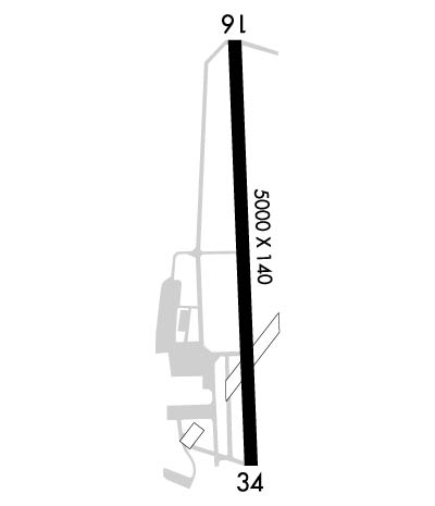
| Lat: N 4640.6 Long: W 12259.0 Elev: 177 Var: -16 Longest Runway: 5000 | ||
| AWOS: 118.02 CTAF: 122.8 | ||
| ||||||||||||||||||||||||||||||||||||||||||||
| ||||||||||||||||||||||||||||||||||||||||||||
| ||||||||||||||||||||||||||||||||||||||||||||
| Rwy | Rwy | |||||||
| 5000x140 | 5000' | 5000x140 | 5000' | |||||
| Runway ID | Single Wheel | Double Wheel | Double Tandem Wheel | Dual Double Wheel |
| 16/34 | 30,000 | 30,000 | 85,000 | N/A |
| These numbers are Advisory and are not limits. The Airport Manager should have more accurate Weight Limits | ||||
 Airport Diagram might not be current. | |
| Facility Name: | CHEHALIS-CENTRALIA |
| City Name: | CHEHALIS |
| County: | LEWIS |
| State abbrev: | WA |
| State Name: | WASHINGTON |
| Ownership: | PUBLICLY OWNED |
| Use: | OPEN TO THE PUBLIC |
| Owner's Name: | CITY OF CHEHALIS |
| Address: | P.O. BOX 1344 |
| CHEHALIS, WA 98532 | |
| Owner's Phone: | 360-748-1230 |
| Manager's Name: | BRANDON RAKES |
| Address: | 880 NW AIRPORT ROAD |
| CHEHALIS, WA 98532 | |
| Phone: | 360-748-1230 |
| FAA Region: | NORTHWEST MOUNTAIN |
| FAA Field Office: | SEA |
| Date | Sunrise | Sunset |
|---|---|---|
| 04/15/25 Tuesday | 6:25 | 20:00 |
| 04/16/25 Wednesday | 6:23 | 20:01 |
| 04/17/25 Thursday | 6:21 | 20:03 |
| 04/18/25 Friday | 6:19 | 20:04 |
| 04/19/25 Saturday | 6:18 | 20:05 |
| 04/20/25 Sunday | 6:16 | 20:07 |
| 04/21/25 Monday | 6:14 | 20:08 |
| 04/22/25 Tuesday | 6:12 | 20:09 |
| 04/23/25 Wednesday | 6:11 | 20:11 |
| 04/24/25 Thursday | 6:09 | 20:12 |
| 04/25/25 Friday | 6:07 | 20:13 |
| 04/26/25 Saturday | 6:05 | 20:15 |
| 04/27/25 Sunday | 6:04 | 20:16 |
| 04/28/25 Monday | 6:02 | 20:17 |
| Airport Attendance Schedule | MON-FRI 0700-1700 |
| Airport Status | OPERATIONAL (This Status can change at any time - please check NOTAMS) |
| Airport Lighting Schedule | ACTVT REIL RWY 16 & 34; PAPI RWY 16; MIRL RWY 16/34 - CTAF. |
| Airport Storage Available | Tie Downs |
| Extra Services Available | Flight Instruction, Aircraft Rental |
| Wind Indicator | YES - (lighted) |
| Control Tower | NO |
| CTAF Frequency | 122.800 |
| Unicom Frequency | 122.800 |
| Rotating Beacon Color | WG |
| Segmented Circle | YES |
| Landing Fee | NO |
| Airport Inspected | STATE - performed by STATE AERONAUTICAL PERSONNEL |
| Inspection Date | 06/24/2024 |
| Type of Fuel Available | Grade 100LL, JET A (freeze point -40C); -10FUEL AVBL 24 HRS. BY CREDIT CARD ONLY. NO DEBIT CARDS. |
| Airframe Repair Service | MAJOR |
| Power Plant Repair Service | MAJOR |
| Latitude | N4640.6 |
| Longitude | W12259.0 (ESTIMATED) |
| Arpt Elevation | 177ft (ESTIMATED) |
| Magnetic Variation | 16E |
| 1 miles W | of CHEHALIS |
| Traffic Pattern Altitude | |
| Sectional Chart | SEATTLE |
| Operations (Reported) | Yearly | Avg. Daily |
|---|---|---|
| General Aviation Transient | 0 | 0 |
| General Aviation Local | 0 | 0 |
| Air Taxi | 0 | 0 |
| Commerical | 0 | 0 |
| Commuter | 0 | 0 |
| Military | 0 | 0 |
| Aircraft based on Field | |
|---|---|
| General Aviation Singles | 0 |
| General Aviation Multi | 0 |
| Jet Aircraft | 0 |
| General Aviation Helicopters | 0 |
| Military Aircraft | 0 |
| Gliders | 0 |
| Ultralights | 0 |
| FSS on field | NO |
| FSS tie-in | SEATTLE |
| FSS Phone | 1-800-WX-BRIEF |
| Who issues Notams | SEA |
| Notam D service at airport | YES |
| ARTCC Name | SEATTLE |
| Airport Certification | |
| Aircraft Rescue & Firefighting Index | None |
| Airport of Entry | No |
| Custom Landing Rights | No |
| Joint Civil/Military | No |
| Military Landing rights | YES |
| NATIONAL PLAN OF INTEGRATED AIRPORT SYSTEMS (NPIAS) |
| GRANT AGREEMENTS UNDER FAAP/ADAP/AIP |
| ASSURANCES PURSUANT TO TITLE VI, CIVIL RIGHTS ACT OF 1964 |
| AGREEMENT UNDER DLAND OR DCLA HAS EXPIRED. |
| TFC PATTERN TO THE WEST ON ALL RY APCHS. |
| POSSIBLE WILDLIFE ON RYS. |
| WEEKEND GLIDER ACTIVITY IN SPRING, SUMMER AND EARLY FALL. |
| FOR CD CTC SEATTLE ARTCC AT 253-351-3694. |
Airport Communications & Frequencies:
| |||||||||||||
| Runway: 16 | Runway: 34 | ||
| Mag heading: | 162° | Mag heading: | 342° |
| Rwy Slope: | .11% Up | Rwy Slope: | -.11% Down |
| Approach: | Approach: | ||
| Pattern: | Right Traffic | Pattern: | Left Traffic |
| Markings: | NONPRECISION INSTRUMENT | Markings: | BASIC |
| Marking Condition: | GOOD | Marking Condition: | GOOD |
| Arresting Dev: | Arresting Dev: | ||
| Lat & Long: | N4641.0 W12259.0 | Lat. & Long.: | N4640.2 W12258.9 |
| Elev: | 170.9 ft. MSL | Elev: | 176.3 ft. MSL |
| TCH: | 35 ft. AGL | TCH: | 41 ft. AGL |
| Visual Glide Path: | 3.00 degrees | Visual Glide Path: | 3.50 degrees |
| Displaced Threshold: | No | Displaced Threshold: | No |
| Touchdown Zone: | YES | Touchdown Zone: | YES |
| Touchdown Elev.: | 175.5 feet | Touchdown Elev.: | 177.2 feet |
| Visual Glide Slope: | 4-Light PAPI on LEFT side of Runway | Visual Glide Slope: | 2-Box VASI on LEFT side of Runway |
| RVR Equipment: | RVR Equipment: | ||
| RVV Equipment: | NO | RVV Equipment: | NO |
| Approach Lights: | Approach Lights: | ||
| REIL: | YES | REIL: | YES |
| Centerline Lights: | NO | Centerline Lights: | NO |
| Touchdown lights: | NO | Touchdown lights: | NO |
| Runway Category: | Runway with a Non-precision Approach having visibility minimums greater than 3/4 mile | Runway Category: | Runway with a Visual Approach |
| Declared Distances: | Declared Distances: |
Thanks for using FltPlan.com
all rights reserved © 1999-2025 by Flight Plan LLC