
| DANVILLE RGNL DANVILLE VA |
| |
| Lat: N 3634.3 Long: W 07920.2 Elev: 571 Var: +09 Longest Runway: 5900 | ||
| AWOS: 128.12 CTAF: 123.05 | ||
| ||||||
| ||||||
| ||||||
|
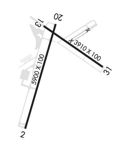
| Rwy | Rwy | |||||||
| 5900x100 | 5900' | 110.70 - 025° | 5900x100 | 5600' | ||||
| 3910x100 | 3910' | 3910x100 | 3910' | |||||
| Runway ID | Single Wheel | Double Wheel | Double Tandem Wheel | Dual Double Wheel |
| 02/20 | 90,000 | 130,000 | N/A | N/A |
| 13/31 | 90,000 | 130,000 | N/A | N/A |
| These numbers are Advisory and are not limits. The Airport Manager should have more accurate Weight Limits | ||||
 Airport Diagram might not be current. | |
| Facility Name: | DANVILLE RGNL |
| City Name: | DANVILLE |
| County: | PITTSYLVANIA |
| State abbrev: | VA |
| State Name: | VIRGINIA |
| Ownership: | PUBLICLY OWNED |
| Use: | OPEN TO THE PUBLIC |
| Owner's Name: | CITY OF DANVILLE |
| Address: | PO BOX 3300 |
| DANVILLE, VA 24543 | |
| Owner's Phone: | 434-799-5110 |
| Manager's Name: | MARC ADELMAN |
| Address: | 424 AIRPORT DRIVE |
| DANVILLE, VA 24540 | |
| Phone: | 434-799-5110 |
| FAA Region: | EASTERN |
| FAA Field Office: | DCA |
| Date | Sunrise | Sunset |
|---|---|---|
| 02/14/25 Friday | 7:07 | 17:57 |
| 02/15/25 Saturday | 7:06 | 17:58 |
| 02/16/25 Sunday | 7:05 | 17:59 |
| 02/17/25 Monday | 7:03 | 18:00 |
| 02/18/25 Tuesday | 7:02 | 18:01 |
| 02/19/25 Wednesday | 7:01 | 18:02 |
| 02/20/25 Thursday | 7:00 | 18:03 |
| 02/21/25 Friday | 6:59 | 18:04 |
| 02/22/25 Saturday | 6:57 | 18:05 |
| 02/23/25 Sunday | 6:56 | 18:06 |
| 02/24/25 Monday | 6:55 | 18:07 |
| 02/25/25 Tuesday | 6:54 | 18:08 |
| 02/26/25 Wednesday | 6:52 | 18:09 |
| 02/27/25 Thursday | 6:51 | 18:10 |
| Airport Attendance Schedule | MON-FRI 0700-1900, SAT-SUN 0700-1900; ARPT UNATTND CHRISTMAS DAY |
| Airport Status | OPERATIONAL (This Status can change at any time - please check NOTAMS) |
| Airport Lighting Schedule | ACTVT HIRL RY 02/20, MIRL RY 13/31, REIL RYS 13, 31, & 20, MALSR RY 02, VASI RY 13, & PAPIS RYS 02, 20, & 31 - CTAF. |
| Airport Storage Available | Tie Downs, Hanger |
| Extra Services Available | Flight Instruction, Aircraft Rental |
| Wind Indicator | YES - (lighted) |
| Control Tower | NO |
| CTAF Frequency | 123.050 |
| Unicom Frequency | 123.050 |
| Rotating Beacon Color | WG |
| Segmented Circle | YES |
| Landing Fee | NO |
| Airport Inspected | FEDERAL - performed by STATE AERONAUTICAL PERSONNEL |
| Inspection Date | 08/24/2023 |
| Type of Fuel Available | Grade 100LL, JET A |
| Airframe Repair Service | MAJOR |
| Power Plant Repair Service | MAJOR |
| Latitude | N3634.3 |
| Longitude | W07920.2 (ESTIMATED) |
| Arpt Elevation | 571ft (SURVEYED) |
| Magnetic Variation | 09W |
| 3 miles E | of DANVILLE |
| Traffic Pattern Altitude | TPA 800 FT AGL LGT ACFT; 1500 FT AGL TURBINE ACFT. |
| Sectional Chart | CINCINNATI |
| Operations (Reported) | Yearly | Avg. Daily |
|---|---|---|
| General Aviation Transient | 0 | 0 |
| General Aviation Local | 0 | 0 |
| Air Taxi | 0 | 0 |
| Commerical | 0 | 0 |
| Commuter | 0 | 0 |
| Military | 0 | 0 |
| Aircraft based on Field | |
|---|---|
| General Aviation Singles | 0 |
| General Aviation Multi | 0 |
| Jet Aircraft | 0 |
| General Aviation Helicopters | 0 |
| Military Aircraft | 0 |
| Gliders | 0 |
| Ultralights | 0 |
| FSS on field | NO |
| FSS tie-in | LEESBURG |
| FSS Phone | 1-800-WX-BRIEF |
| Who issues Notams | DAN |
| Notam D service at airport | YES |
| ARTCC Name | WASHINGTON |
| Airport Certification | |
| Aircraft Rescue & Firefighting Index | None |
| Airport of Entry | No |
| Custom Landing Rights | No |
| Joint Civil/Military | No |
| Military Landing rights | YES |
| NATIONAL PLAN OF INTEGRATED AIRPORT SYSTEMS (NPIAS) |
| GRANT AGREEMENTS UNDER FAAP/ADAP/AIP |
| ADVANCE PLANNING AGREEMENT UNDER FAAP |
| ASSURANCES PURSUANT TO TITLE VI, CIVIL RIGHTS ACT OF 1964 |
| AGREEMENT UNDER DLAND OR DCLA HAS EXPIRED. |
| BIRDS & DEER ON & INVOF ARPT. |
| RY 02 IS DESIGNATED CALM WIND RY. |
| CTC ARPT ADMIN PRIOR TO CONDUCTING SPECIALIZED AERO ACTIVITIES 434-799-5110. |
| TREES PENETRATING 7:1 TRANSITIONAL SURFACE, RY 31 BOTH SIDES, FIRST 1000 FT. |
| FOR CD IF UNA TO CTC ON FSS FREQ, CTC WASHINGTON ARTCC AT 703-771-3587. |
Airport Communications & Frequencies:
| |||||||||
| Runway: 02 | Runway: 20 | ||
| Mag heading: | 25° | Mag heading: | 205° |
| Rwy Slope: | .49% Up | Rwy Slope: | -.49% Down |
| Approach: | ILS | Approach: | |
| Pattern: | Left Traffic | Pattern: | Left Traffic |
| Markings: | PRECISION INSTRUMENT | Markings: | NONPRECISION INSTRUMENT |
| Marking Condition: | GOOD | Marking Condition: | GOOD |
| Arresting Dev: | Arresting Dev: | ||
| Lat & Long: | N3633.8 W07920.5 | Lat. & Long.: | N3634.7 W07920.2 |
| Elev: | 535.6 ft. MSL | Elev: | 564.6 ft. MSL |
| TCH: | 55 ft. AGL | TCH: | 47 ft. AGL |
| Visual Glide Path: | 3.00 degrees | Visual Glide Path: | 3.00 degrees |
| Displaced Threshold: | No | Displaced Threshold: | 300 feet |
| Touchdown Zone: | YES | Touchdown Zone: | YES |
| Touchdown Elev.: | 558.5 feet | Touchdown Elev.: | 564.9 feet |
| Visual Glide Slope: | 4-Light PAPI on LEFT side of Runway | Visual Glide Slope: | 4-Light PAPI on LEFT side of Runway |
| RVR Equipment: | RVR Equipment: | ||
| RVV Equipment: | NO | RVV Equipment: | NO |
| Approach Lights: | MALSR - 1,400 foot medium intensity approach lighting system with runway alignment indicator lights | Approach Lights: | |
| REIL: | NO | REIL: | YES |
| Centerline Lights: | NO | Centerline Lights: | NO |
| Touchdown lights: | NO | Touchdown lights: | NO |
| Runway Category: | Precision Instrument Runway | Runway Category: | Runway with a Non-precision Approach having visibility minimums greater than 3/4 mile |
| Declared Distances: | TORA:5600' TODA:5900' ASDA:5600' LDA:5600' | Declared Distances: | TORA:5900' TODA:5900' ASDA:5900' LDA:5600' |
| Obstructions: | TREE | Obstructions: | TREE |
| Marked: | NOT Marked/Lighted | Marked: | NOT Marked/Lighted |
| Clearance slope: | 38:1 | Clearance slope: | 32:1; SLP TO DTHR 39:1. |
| Obstruction height: | 53 feet AGL | Obstruction height: | 129 feet AGL |
| Dist. from runway: | 2255 feet | Dist. from runway: | 4436 feet |
| Centerline offset: | 750 left of centerline | Centerline offset: | 552 feet right of centerline |
| Comments: | Comments: |
| Runway: 13 | Runway: 31 | ||
| Mag heading: | 134° | Mag heading: | 314° |
| Rwy Slope: | -1.11% Down | Rwy Slope: | 1.11% Up |
| Approach: | Approach: | ||
| Pattern: | Left Traffic | Pattern: | Left Traffic |
| Markings: | BASIC | Markings: | NONPRECISION INSTRUMENT |
| Marking Condition: | GOOD | Marking Condition: | GOOD |
| Arresting Dev: | Arresting Dev: | ||
| Lat & Long: | N3634.7 W07920.3 | Lat. & Long.: | N3634.3 W07919.6 |
| Elev: | 571.1 ft. MSL | Elev: | 527.8 ft. MSL |
| TCH: | 28 ft. AGL | TCH: | 76 ft. AGL |
| Visual Glide Path: | 3.00 degrees | Visual Glide Path: | 4.00 degrees |
| Displaced Threshold: | No | Displaced Threshold: | No |
| Touchdown Zone: | YES | Touchdown Zone: | YES |
| Touchdown Elev.: | 571.1 feet | Touchdown Elev.: | 561.1 feet |
| Visual Glide Slope: | 2-Box VASI on LEFT side of Runway | Visual Glide Slope: | 2-Light PAPI on LEFT side of Runway |
| RVR Equipment: | RVR Equipment: | ||
| RVV Equipment: | NO | RVV Equipment: | NO |
| Approach Lights: | Approach Lights: | ||
| REIL: | YES | REIL: | YES |
| Centerline Lights: | NO | Centerline Lights: | NO |
| Touchdown lights: | NO | Touchdown lights: | NO |
| Runway Category: | Runway with a Visual Approach | Runway Category: | Runway with a Non-precision Approach having visibility minimums greater than 3/4 mile |
| Declared Distances: | Declared Distances: | ||
| Obstructions: | TREE | Obstructions: | TREES |
| Marked: | NOT Marked/Lighted | Marked: | NOT Marked/Lighted |
| Clearance slope: | 20:1 | Clearance slope: | 13:1 |
| Obstruction height: | 120 feet AGL | Obstruction height: | 19 feet AGL |
| Dist. from runway: | 2708 feet | Dist. from runway: | 464 feet |
| Centerline offset: | 429 left of centerline | Centerline offset: | 61 feet left of centerline |
| Comments: | Comments: |
Thanks for using FltPlan.com
all rights reserved © 1999-2025 by Flight Plan LLC
