
| GILA BEND MUNI GILA BEND AZ |
| |
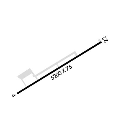
| Lat: N 3257.6 Long: W 11240.4 Elev: 789 Var: -13 Longest Runway: 5200 | ||
| CTAF: 122.8 | ||
| ||||||
|
| Rwy | Rwy | |||||||
| 5200x75 | 5200' | 5200x75 | 5200' | |||||
| Runway ID | Single Wheel | Double Wheel | Double Tandem Wheel | Dual Double Wheel |
| 04/22 | 12,500 | N/A | N/A | N/A |
| These numbers are Advisory and are not limits. The Airport Manager should have more accurate Weight Limits | ||||
| FltPlan does not have IFR approach charts available for KE63. |
 Airport Diagram might not be current. | |
| Facility Name: | GILA BEND MUNI |
| City Name: | GILA BEND |
| County: | MARICOPA |
| State abbrev: | AZ |
| State Name: | ARIZONA |
| Ownership: | PUBLICLY OWNED |
| Use: | OPEN TO THE PUBLIC |
| Owner's Name: | TOWN OF GILA BEND |
| Address: | PO BOX A |
| GILA BEND, AZ 85337 | |
| Owner's Phone: | (623) 810-4662 |
| Manager's Name: | COREY DRURY |
| Address: | |
| Phone: | (623) 810-4662; ALTERNATE NUMBER 602-702-0891. JESUS BALDENEGRO. |
| FAA Region: | WESTERN-PACIFIC |
| FAA Field Office: | PHX |
| Date | Sunrise | Sunset |
|---|---|---|
| 09/24/21 Friday | 6:20 | 18:25 |
| 09/25/21 Saturday | 6:21 | 18:24 |
| 09/26/21 Sunday | 6:21 | 18:22 |
| 09/27/21 Monday | 6:22 | 18:21 |
| 09/28/21 Tuesday | 6:23 | 18:19 |
| 09/29/21 Wednesday | 6:23 | 18:18 |
| 09/30/21 Thursday | 6:24 | 18:17 |
| 10/01/21 Friday | 6:25 | 18:15 |
| 10/02/21 Saturday | 6:25 | 18:14 |
| 10/03/21 Sunday | 6:26 | 18:13 |
| 10/04/21 Monday | 6:27 | 18:12 |
| 10/05/21 Tuesday | 6:28 | 18:10 |
| 10/06/21 Wednesday | 6:28 | 18:09 |
| 10/07/21 Thursday | 6:29 | 18:08 |
| Airport Attendance Schedule | UNATTENDED |
| Airport Status | OPERATIONAL (This Status can change at any time - please check NOTAMS) |
| Airport Lighting Schedule | ACTVT MIRL RY 04/22 - CTAF. |
| Airport Storage Available | Tie Downs |
| Extra Services Available | NONE |
| Wind Indicator | YES - (lighted) |
| Control Tower | NO |
| CTAF Frequency | 122.800 |
| Unicom Frequency | 122.800 |
| Rotating Beacon Color | CLEAR-GREEN (Light Land Airport) |
| Segmented Circle | YES |
| Landing Fee | NO |
| Airport Inspected | STATE - performed by PRIVATE CONTRACT PERSONNEL |
| Inspection Date | 03/31/2020 |
| Type of Fuel Available | Grade 100LL; -1024 HR SELF-SERVICE AVAILABLE WITH MAJOR CREDIT CARD AFTER 09/01/2014 |
| Airframe Repair Service | NONE |
| Power Plant Repair Service | NONE |
| Latitude | N3257.6 |
| Longitude | W11240.4 (ESTIMATED) |
| Arpt Elevation | 788ft (ESTIMATED) |
| Magnetic Variation | 13E |
| 2 miles E | of GILA BEND |
| Traffic Pattern Altitude | 800 |
| Sectional Chart | PHOENIX |
| Operations (Reported) | Yearly | Avg. Daily |
|---|---|---|
| General Aviation Transient | 6203 | 17 |
| General Aviation Local | 35114 | 96 |
| Air Taxi | 624 | 2 |
| Commerical | 0 | 0 |
| Commuter | 0 | 0 |
| Military | 59 | 0 |
| Aircraft based on Field | |
|---|---|
| General Aviation Singles | 2 |
| General Aviation Multi | 0 |
| Jet Aircraft | 0 |
| General Aviation Helicopters | 0 |
| Military Aircraft | 0 |
| Gliders | 0 |
| Ultralights | 0 |
| FSS on field | NO |
| FSS tie-in | PRESCOTT |
| FSS Phone | 1-800-WX-BRIEF |
| Who issues Notams | PRC |
| Notam D service at airport | YES |
| ARTCC Name | ALBUQUERQUE |
| Airport Certification | |
| Aircraft Rescue & Firefighting Index | None |
| Airport of Entry | No |
| Custom Landing Rights | No |
| Joint Civil/Military | No |
| Military Landing rights | YES |
| NATIONAL PLAN OF INTEGRATED AIRPORT SYSTEMS (NPIAS) |
| GRANT AGREEMENTS UNDER FAAP/ADAP/AIP |
| CONVEYANCE UNDER SCETION 16, FEDERAL AIRPORT ACT OF 1946 OR SECTION 23, AIRPORT AND AIRWAY DEVELOPMENT ACT OF 1970 |
| ASSURANCES PURSUANT TO TITLE VI, CIVIL RIGHTS ACT OF 1964 |
| AREA BESIDES RWY NARROWS TO 30 FT AT CULVERT. |
| RWY 04/22 PRIMARY SFC, +5-20 FT BRUSH & TREES, 100-125 FT S OF RWY CNTRLN. |
| FOR CD CTC LUKE APCH AT 623-856-7361. IF UNA, CTC PHOENIX APCH AT 602-306-2565. |
Airport Communications & Frequencies:
| |||||||||
| Runway: 04 | Runway: 22 | ||
| Mag heading: | N/A | Mag heading: | N/A |
| Rwy Slope: | .28% Up | Rwy Slope: | -.28% Down |
| Approach: | Approach: | ||
| Pattern: | Left Traffic | Pattern: | Left Traffic |
| Markings: | NONPRECISION INSTRUMENT | Markings: | NONPRECISION INSTRUMENT |
| Marking Condition: | GOOD | Marking Condition: | GOOD |
| Arresting Dev: | Arresting Dev: | ||
| Lat & Long: | N3257.4 W11240.8 | Lat. & Long.: | N3257.8 W11240.0 |
| Elev: | 774.2 ft. MSL | Elev: | 788.7 ft. MSL |
| TCH: | 40 ft. AGL | TCH: | 40 ft. AGL |
| Visual Glide Path: | 3.00 degrees | Visual Glide Path: | 3.00 degrees |
| Displaced Threshold: | No | Displaced Threshold: | No |
| Touchdown Zone: | YES | Touchdown Zone: | YES |
| Touchdown Elev.: | 774.2 feet | Touchdown Elev.: | 788.7 feet |
| Visual Glide Slope: | 2-Light PAPI on LEFT side of Runway | Visual Glide Slope: | 2-Light PAPI on LEFT side of Runway |
| RVR Equipment: | RVR Equipment: | ||
| RVV Equipment: | NO | RVV Equipment: | NO |
| Approach Lights: | Approach Lights: | ||
| REIL: | NO | REIL: | NO |
| Centerline Lights: | NO | Centerline Lights: | NO |
| Touchdown lights: | NO | Touchdown lights: | NO |
| Runway Category: | Runway with a Visual Approach | Runway Category: | Runway with a Visual Approach |
| Declared Distances: | Declared Distances: | ||
| Obstructions: | BRUSH | Obstructions: | BRUSH |
| Marked: | NOT Marked/Lighted | Marked: | NOT Marked/Lighted |
| Clearance slope: | 5:1 | Clearance slope: | 2:1 |
| Obstruction height: | 12 feet AGL | Obstruction height: | 15 feet AGL |
| Dist. from runway: | 266 feet | Dist. from runway: | 235 feet |
| Centerline offset: | 30 right of centerline | Centerline offset: | 35 feet left of centerline |
| Comments: | RWY 04 +3-20 FT BRUSH & TREES, 0-200 FT FM THLD, 110-125 FT RIGHT OF CNTRLN. +4 FT BERM 115 FT RIGHT OF CNTRLN, ENTIRE LENGHT OF RWY. | Comments: | RWY 22 +3-15 FT BRUSH, 0- 200 FT FM THLD, 87-125 FT LEFT OF CNTRLN. +2-4 FT BRUSH, 0-200 FT FM THLD, 30-125 FT RIGHT OF CNTRLN. +4 FT DITCH, 0-200 FT FM THLD, 80 FT BOTH SIDES OF CNTRLN. |
Thanks for using FltPlan.com
all rights reserved © 1999-2021 by Flight Plan LLC
