| MEADOW LAKE COLORADO SPRINGS CO |
| |
| Lat: N 3856.6 Long: W 10434.2 Elev: 6878 Var: -07 Longest Runway: 6001 | ||
| AWOS: 118.45 CTAF: 122.7 | ||
| ||||||||||||||||||||||||||||||||||||||||||||||||||||||||||||||||||||
| ||||||||||||||||||||||||||||||||||||||||||||||||||||||||||||||||||||
| ||||||||||||||||||||||||||||||||||||||||||||||||||||||||||||||||||||
| ||||||||||||||||||||||||||||||||||||||||||||||||||||||||||||||||||||
| Rwy | Rwy | |||||||
| 2126x35 | 2126' | 2126x35 | 2126' | |||||
| 6001x60 | 6001' | 6001x60 | 6001' | |||||
| 5001x200 | 5001' | 5001x200 | 5001' | |||||
| Runway ID | Single Wheel | Double Wheel | Double Tandem Wheel | Dual Double Wheel |
| 08/26 | N/A | N/A | N/A | N/A |
| 15/33 | 12,500 | N/A | N/A | N/A |
| 16/34 | N/A | N/A | N/A | N/A |
| These numbers are Advisory and are not limits. The Airport Manager should have more accurate Weight Limits | ||||
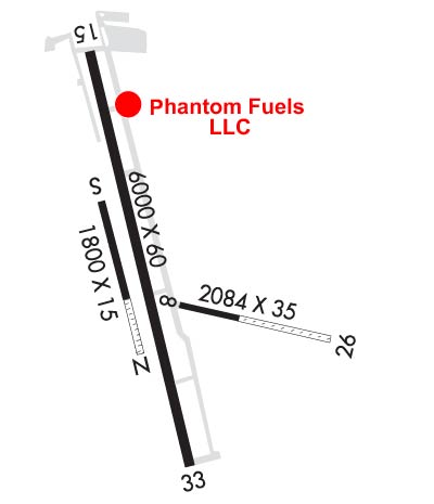 Airport Diagram might not be current. | |
| Facility Name: | MEADOW LAKE |
| City Name: | COLORADO SPRINGS |
| County: | EL PASO |
| State abbrev: | CO |
| State Name: | COLORADO |
| Ownership: | PRIVATELY OWNED |
| Use: | OPEN TO THE PUBLIC |
| Owner's Name: | MEADOW LAKE AIRPORT ASSOC., INC.; DAVE ELLIOTT ASSOCIATION PRESIDENT. |
| Address: | 13625 JUDGE ORR ROAD |
| PEYTON, CO 80831 | |
| Owner's Phone: | 719-339-0928 |
| Manager's Name: | DAVE ELLIOTT |
| Address: | 13625 JUDGE ORR ROAD |
| PEYTON, CO 80831 | |
| Phone: | 719-339-0928; ALTN PHONE IS MIKE BARR AT (719) 287-4204 |
| FAA Region: | NORTHWEST MOUNTAIN |
| FAA Field Office: | DEN |
| Date | Sunrise | Sunset |
|---|---|---|
| 04/16/25 Wednesday | 6:21 | 19:36 |
| 04/17/25 Thursday | 6:19 | 19:37 |
| 04/18/25 Friday | 6:18 | 19:38 |
| 04/19/25 Saturday | 6:16 | 19:39 |
| 04/20/25 Sunday | 6:15 | 19:40 |
| 04/21/25 Monday | 6:14 | 19:41 |
| 04/22/25 Tuesday | 6:12 | 19:42 |
| 04/23/25 Wednesday | 6:11 | 19:43 |
| 04/24/25 Thursday | 6:09 | 19:44 |
| 04/25/25 Friday | 6:08 | 19:45 |
| 04/26/25 Saturday | 6:07 | 19:46 |
| 04/27/25 Sunday | 6:06 | 19:47 |
| 04/28/25 Monday | 6:04 | 19:48 |
| 04/29/25 Tuesday | 6:03 | 19:49 |
| Airport Attendance Schedule | 7 Days A Week 0800-1700 |
| Airport Status | OPERATIONAL (This Status can change at any time - please check NOTAMS) |
| Airport Lighting Schedule | ACTVT REIL RWY 15 & 33; ACTVT & INCR INTST MIRL RWY 15/33 - CTAF. PAPI RWY 15 & 33 ON CONSLY. |
| Airport Storage Available | Tie Downs, Hanger |
| Extra Services Available | Glider, Flight Instruction, Aircraft Rental, Aircraft Sales, Glider Towing |
| Wind Indicator | YES - (lighted) |
| Control Tower | NO |
| CTAF Frequency | 122.700 |
| Unicom Frequency | 122.700 |
| Rotating Beacon Color | WG |
| Segmented Circle | YES |
| Landing Fee | NO |
| Airport Inspected | STATE - performed by STATE AERONAUTICAL PERSONNEL |
| Inspection Date | 01/11/2022 |
| Type of Fuel Available | Grade 100LL; -10100LL AVBL 24 HRS SELF SVC CREDIT CARD. |
| Airframe Repair Service | MAJOR |
| Power Plant Repair Service | MAJOR |
| Latitude | N3856.6 |
| Longitude | W10434.2 (ESTIMATED) |
| Arpt Elevation | 6878ft (SURVEYED) |
| Magnetic Variation | 07E |
| 14 miles NE | of COLORADO SPRINGS |
| Traffic Pattern Altitude | |
| Sectional Chart | DENVER |
| Operations (Reported) | Yearly | Avg. Daily |
|---|---|---|
| General Aviation Transient | 0 | 0 |
| General Aviation Local | 0 | 0 |
| Air Taxi | 0 | 0 |
| Commerical | 0 | 0 |
| Commuter | 0 | 0 |
| Military | 0 | 0 |
| Aircraft based on Field | |
|---|---|
| General Aviation Singles | 0 |
| General Aviation Multi | 0 |
| Jet Aircraft | 0 |
| General Aviation Helicopters | 0 |
| Military Aircraft | 0 |
| Gliders | 0 |
| Ultralights | 0 |
| FSS on field | NO |
| FSS tie-in | DENVER |
| FSS Phone | 1-800-WX-BRIEF |
| Who issues Notams | DEN |
| Notam D service at airport | YES |
| ARTCC Name | DENVER |
| Airport Certification | |
| Aircraft Rescue & Firefighting Index | None |
| Airport of Entry | No |
| Custom Landing Rights | No |
| Joint Civil/Military | No |
| Military Landing rights | No |
| NATIONAL PLAN OF INTEGRATED AIRPORT SYSTEMS (NPIAS) |
| CTN: ; INTENSIVE USAF STUDENT TNG INVOF COLORADO SPRINGS & PUEBLO COLORADO. |
| RWY 26: 15 FT ROAD EXTDS EAST FM THLD. |
| CTN: PWRD PARAGLIDERS AND MOBILE AEROSTATS OPER SOUTHEAST SIDE OF ARPT SFC-500 FT. |
| RWY 16/34 HAS EDGES AND THLDS MKD WITH WHITE TIRES. |
| FOR CD CTC COLORADO SPRINGS APCH AT 719-556-9105. |
| RWY 08/26 EDGES MKD WITH WHITE REFLECTORS AND TIRES. |
| GLIDERS OPERATE ON 16/34 AND WEST SIDE OF ARPT. |
| RWY 26; 4 FT TERRAIN 5 FT FM RWY EDGE FIRST 100 FT ON BOTH SIDES OF RWY. |
| WILDLIFE ON AND INVOF OF AIRPORT. |
| RWY 26; 4 FT FENCE 50 FT RIGHT OF CNTRLN 95 FT FM THLD. |
| RWY 08/2 6 RWY 08/26 1149 FT GRVL ON E END OF RWY, 925 FT ASPH ON W END OF RWY. |
Airport Communications & Frequencies:
| ||||||||||||||
| Runway: 08 | Runway: 26 | ||
| Mag heading: | 84° | Mag heading: | 264° |
| Rwy Slope: | -1.19% Down | Rwy Slope: | 1.19% Up |
| Approach: | Approach: | ||
| Pattern: | Right Traffic | Pattern: | Left Traffic |
| Markings: | NONE | Markings: | NONE |
| Marking Condition: | POOR | Marking Condition: | POOR |
| Arresting Dev: | Arresting Dev: | ||
| Lat & Long: | N3856.8 W10434.2 | Lat. & Long.: | N3856.8 W10433.8 |
| Elev: | 6824.8 ft. MSL | Elev: | 6799.4 ft. MSL |
| TCH: | TCH: | ||
| Visual Glide Path: | Visual Glide Path: | ||
| Displaced Threshold: | No | Displaced Threshold: | No |
| Touchdown Zone: | YES | Touchdown Zone: | YES |
| Touchdown Elev.: | 6824.8 feet | Touchdown Elev.: | 6824.8 feet |
| Visual Glide Slope: | Visual Glide Slope: | ||
| RVR Equipment: | RVR Equipment: | ||
| RVV Equipment: | NO | RVV Equipment: | NO |
| Approach Lights: | Approach Lights: | ||
| REIL: | NO | REIL: | NO |
| Centerline Lights: | NO | Centerline Lights: | NO |
| Touchdown lights: | NO | Touchdown lights: | NO |
| Runway Category: | Runway with a Visual Approach | Runway Category: | Runway with a Visual Approach |
| Declared Distances: | Declared Distances: | ||
| Obstructions: | Obstructions: | ROAD | |
| Marked: | Marked: | NOT Marked/Lighted | |
| Clearance slope: | 20:1 | Clearance slope: | 1:1 |
| Obstruction height: | Obstruction height: | 10 feet AGL | |
| Dist. from runway: | Dist. from runway: | 0 feet | |
| Centerline offset: | Centerline offset: | ||
| Comments: | Comments: |
| Runway: 15 | Runway: 33 | ||
| Mag heading: | 153° | Mag heading: | 333° |
| Rwy Slope: | -1.44% Down | Rwy Slope: | 1.44% Up |
| Approach: | Approach: | ||
| Pattern: | Left Traffic | Pattern: | Right Traffic |
| Markings: | NONPRECISION INSTRUMENT | Markings: | NONPRECISION INSTRUMENT |
| Marking Condition: | POOR | Marking Condition: | POOR |
| Arresting Dev: | Arresting Dev: | ||
| Lat & Long: | N3857.2 W10434.5 | Lat. & Long.: | N3856.3 W10434.1 |
| Elev: | 6878.1 ft. MSL | Elev: | 6791.4 ft. MSL |
| TCH: | 42 ft. AGL | TCH: | 39 ft. AGL |
| Visual Glide Path: | 3.50 degrees | Visual Glide Path: | 3.00 degrees |
| Displaced Threshold: | No | Displaced Threshold: | No |
| Touchdown Zone: | YES | Touchdown Zone: | YES |
| Touchdown Elev.: | 6878.1 feet | Touchdown Elev.: | 6826.0 feet |
| Visual Glide Slope: | 2-Light PAPI on LEFT side of Runway | Visual Glide Slope: | 2-Light PAPI on LEFT side of Runway |
| RVR Equipment: | RVR Equipment: | ||
| RVV Equipment: | NO | RVV Equipment: | NO |
| Approach Lights: | Approach Lights: | ||
| REIL: | YES | REIL: | YES |
| Centerline Lights: | NO | Centerline Lights: | NO |
| Touchdown lights: | NO | Touchdown lights: | NO |
| Runway Category: | Runway with a Visual Approach | Runway Category: | Runway with a Visual Approach |
| Declared Distances: | Declared Distances: | ||
| Obstructions: | ROAD | Obstructions: | |
| Marked: | NOT Marked/Lighted | Marked: | |
| Clearance slope: | 19:1 | Clearance slope: | 20:1 |
| Obstruction height: | 18 feet AGL | Obstruction height: | |
| Dist. from runway: | 558 feet | Dist. from runway: | |
| Centerline offset: | 115 left of centerline | Centerline offset: | |
| Comments: | Comments: |
| Runway: 16 | Runway: 34 | ||
| Mag heading: | 153° | Mag heading: | 333° |
| Rwy Slope: | .00% | Rwy Slope: | .00% |
| Approach: | Approach: | ||
| Pattern: | Left Traffic | Pattern: | Left Traffic |
| Markings: | NONE | Markings: | NONE |
| Marking Condition: | POOR | Marking Condition: | POOR |
| Arresting Dev: | Arresting Dev: | ||
| Lat & Long: | N3856.7 W10434.4 | Lat. & Long.: | N3855.9 W10434.0 |
| Elev: | 6776.8 ft. MSL | Elev: | 6776.8 ft. MSL |
| TCH: | TCH: | ||
| Visual Glide Path: | Visual Glide Path: | ||
| Displaced Threshold: | No | Displaced Threshold: | No |
| Touchdown Zone: | YES | Touchdown Zone: | YES |
| Touchdown Elev.: | 6833.5 feet | Touchdown Elev.: | 6812.2 feet |
| Visual Glide Slope: | Visual Glide Slope: | ||
| RVR Equipment: | RVR Equipment: | ||
| RVV Equipment: | NO | RVV Equipment: | NO |
| Approach Lights: | Approach Lights: | ||
| REIL: | NO | REIL: | NO |
| Centerline Lights: | NO | Centerline Lights: | NO |
| Touchdown lights: | NO | Touchdown lights: | NO |
| Runway Category: | Runway with a Visual Approach | Runway Category: | Runway with a Visual Approach |
| Declared Distances: | Declared Distances: | ||
| Obstructions: | Unknown | Obstructions: | |
| Marked: | NOT Marked/Lighted | Marked: | |
| Clearance slope: | 11:1 | Clearance slope: | 20:1 |
| Obstruction height: | 5 feet AGL | Obstruction height: | |
| Dist. from runway: | 56 feet | Dist. from runway: | |
| Centerline offset: | 79 | Centerline offset: | |
| Comments: | Comments: |
Thanks for using FltPlan.com
all rights reserved © 1999-2025 by Flight Plan LLC