
| MILLVILLE MUNI MILLVILLE NJ |
| |
| Lat: N 3922.1 Long: W 07504.3 Elev: 85 Var: +11 Longest Runway: 6003 | ||
| AWOS: 119.6 CTAF: 123.0 | ||
| ||||||
| ||||||
|
| Rwy | Rwy | |||||||
| 6003x150 | 6003' | 110.90 - 100° | 6003x150 | 6003' | ||||
| 5058x150 | 5058' | 5058x150 | 5058' | |||||
| Runway ID | Single Wheel | Double Wheel | Double Tandem Wheel | Dual Double Wheel |
| 10/28 | 120,000 | 179,000 | 263,000 | N/A |
| 14/32 | 40,000 | 65,000 | 125,000 | N/A |
| These numbers are Advisory and are not limits. The Airport Manager should have more accurate Weight Limits | ||||
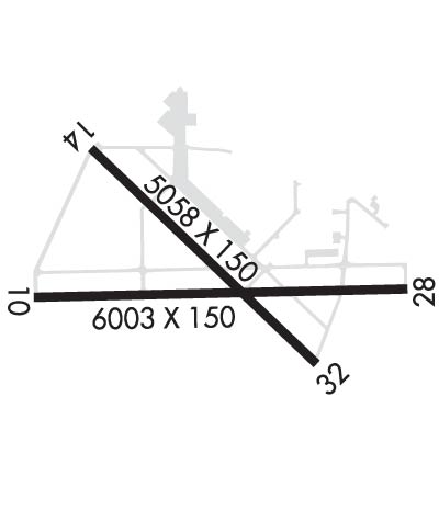 Airport Diagram might not be current. | |
| Facility Name: | MILLVILLE MUNI |
| City Name: | MILLVILLE |
| County: | CUMBERLAND |
| State abbrev: | NJ |
| State Name: | NEW JERSEY |
| Ownership: | PUBLICLY OWNED |
| Use: | OPEN TO THE PUBLIC |
| Owner's Name: | DRBA-CITY OF MILLVILLE |
| Address: | 104 LEDDON STREET |
| MILLVILLE, NJ 08332 | |
| Owner's Phone: | 856-825-1244 |
| Manager's Name: | TOM BERRY |
| Address: | ADMIN BLDG, 104 LEDDON ST |
| MILLVILLE, NJ 08332 | |
| Phone: | 856-825-1244 |
| FAA Region: | EASTERN |
| FAA Field Office: | HAR |
| Date | Sunrise | Sunset |
|---|---|---|
| 09/24/21 Friday | 6:49 | 18:55 |
| 09/25/21 Saturday | 6:50 | 18:53 |
| 09/26/21 Sunday | 6:51 | 18:51 |
| 09/27/21 Monday | 6:52 | 18:50 |
| 09/28/21 Tuesday | 6:53 | 18:48 |
| 09/29/21 Wednesday | 6:54 | 18:46 |
| 09/30/21 Thursday | 6:55 | 18:45 |
| 10/01/21 Friday | 6:56 | 18:43 |
| 10/02/21 Saturday | 6:57 | 18:42 |
| 10/03/21 Sunday | 6:58 | 18:40 |
| 10/04/21 Monday | 6:59 | 18:38 |
| 10/05/21 Tuesday | 7:00 | 18:37 |
| 10/06/21 Wednesday | 7:01 | 18:35 |
| 10/07/21 Thursday | 7:02 | 18:34 |
| Airport Attendance Schedule | 7 Days A Week 0600-1800 |
| Airport Status | OPERATIONAL (This Status can change at any time - please check NOTAMS) |
| Airport Lighting Schedule | ACTVT MALSR RWY 10; MIRL RWY 10/28 & 14/32 - CTAF. |
| Airport Storage Available | Tie Downs |
| Extra Services Available | Flight Instruction, Aircraft Rental |
| Wind Indicator | YES - (lighted) |
| Control Tower | NO |
| CTAF Frequency | 123.000 |
| Unicom Frequency | 123.000 |
| Rotating Beacon Color | CLEAR-GREEN (Light Land Airport) |
| Segmented Circle | NO |
| Landing Fee | NO |
| Airport Inspected | STATE - performed by STATE AERONAUTICAL PERSONNEL |
| Inspection Date | 04/28/2021 |
| Type of Fuel Available | Grade 100LL, JET A (freeze point -40C); -10SELF SERV AVBL H24 WITH CREDIT CARD. |
| Airframe Repair Service | NONE |
| Power Plant Repair Service | MINOR |
| Latitude | N3922.1 |
| Longitude | W07504.3 (ESTIMATED) |
| Arpt Elevation | 84ft (SURVEYED) |
| Magnetic Variation | 11W |
| 3 miles SW | of MILLVILLE |
| Traffic Pattern Altitude | |
| Sectional Chart | WASHINGTON |
| Operations (Reported) | Yearly | Avg. Daily |
|---|---|---|
| General Aviation Transient | 19522 | 53 |
| General Aviation Local | 26322 | 72 |
| Air Taxi | 0 | 0 |
| Commerical | 0 | 0 |
| Commuter | 0 | 0 |
| Military | 100 | 0 |
| Aircraft based on Field | |
|---|---|
| General Aviation Singles | 30 |
| General Aviation Multi | 3 |
| Jet Aircraft | 1 |
| General Aviation Helicopters | 1 |
| Military Aircraft | 0 |
| Gliders | 1 |
| Ultralights | 0 |
| FSS on field | NO |
| FSS tie-in | MILLVILLE |
| FSS Phone | 1-800-WX-BRIEF |
| Who issues Notams | MIV |
| Notam D service at airport | YES |
| ARTCC Name | WASHINGTON |
| Airport Certification | |
| Aircraft Rescue & Firefighting Index | None |
| Airport of Entry | No |
| Custom Landing Rights | No |
| Joint Civil/Military | No |
| Military Landing rights | YES |
| NATIONAL PLAN OF INTEGRATED AIRPORT SYSTEMS (NPIAS) |
| GRANT AGREEMENTS UNDER FAAP/ADAP/AIP |
| SURPLUS PROPERTY AGREEMENT UNDER REGULATION 16-WAA |
| ASSURANCES PURSUANT TO TITLE VI, CIVIL RIGHTS ACT OF 1964 |
| AGREEMENT UNDER DLAND OR DCLA HAS EXPIRED. |
| MAIN APRON CLSD TO TRANSIENT ACFT NORTH OF TWY K. |
| BIRDS ON & INVOF ARPT. |
| FOR CD IF UNA TO CTC ON FSS FREQ, CTC ATLANTIC CITY APPROACH AT 609-485-6193. |
| ARPT CLSD TO ULTRALIGHT ACFT, GLIDER OPS AND FORMATION FLIGHTS EXCEPT PPR (856) 825-1244 MON-FRI 0800-1600. |
| PAEW WITHIN ALL RWY AND TWY SAFETY AREAS DAILY MAY - OCT. |
| TWY G NOT TO BE USED BY ACFT WITH WING SPAN GREATER THAN 79 FT ON TWY G NORTH OF TWY A. |
| RWY 10 CALM WIND RWY. |
Airport Communications & Frequencies:
| ||||||||||||||
| Runway: 10 | Runway: 28 | ||
| Mag heading: | 101° | Mag heading: | 281° |
| Rwy Slope: | .18% Up | Rwy Slope: | -.18% Down |
| Approach: | ILS | Approach: | |
| Pattern: | Left Traffic | Pattern: | Left Traffic |
| Markings: | PRECISION INSTRUMENT | Markings: | NONPRECISION INSTRUMENT |
| Marking Condition: | GOOD | Marking Condition: | GOOD |
| Arresting Dev: | Arresting Dev: | ||
| Lat & Long: | N3922.0 W07504.9 | Lat. & Long.: | N3922.0 W07503.7 |
| Elev: | 73.5 ft. MSL | Elev: | 84.4 ft. MSL |
| TCH: | 53 ft. AGL | TCH: | 29 ft. AGL |
| Visual Glide Path: | 3.00 degrees | Visual Glide Path: | 3.00 degrees |
| Displaced Threshold: | No | Displaced Threshold: | No |
| Touchdown Zone: | YES | Touchdown Zone: | YES |
| Touchdown Elev.: | 73.5 feet | Touchdown Elev.: | 84.6 feet |
| Visual Glide Slope: | 4-Light PAPI on LEFT side of Runway | Visual Glide Slope: | 4-Light PAPI on LEFT side of Runway |
| RVR Equipment: | RVR Equipment: | ||
| RVV Equipment: | NO | RVV Equipment: | NO |
| Approach Lights: | MALSR - 1,400 foot medium intensity approach lighting system with runway alignment indicator lights | Approach Lights: | |
| REIL: | NO | REIL: | NO |
| Centerline Lights: | NO | Centerline Lights: | NO |
| Touchdown lights: | NO | Touchdown lights: | NO |
| Runway Category: | Precision Instrument Runway | Runway Category: | Runway with a Non-precision Approach having visibility minimums greater than 3/4 mile |
| Declared Distances: | Declared Distances: | ||
| Obstructions: | TREES | Obstructions: | |
| Marked: | NOT Marked/Lighted | Marked: | |
| Clearance slope: | 35:1 | Clearance slope: | |
| Obstruction height: | 65 feet AGL | Obstruction height: | |
| Dist. from runway: | 2480 feet | Dist. from runway: | |
| Centerline offset: | 170 left of centerline | Centerline offset: | |
| Comments: | Comments: |
| Runway: 14 | Runway: 32 | ||
| Mag heading: | 146° | Mag heading: | 326° |
| Rwy Slope: | .03% Up | Rwy Slope: | -.03% Down |
| Approach: | Approach: | ||
| Pattern: | Left Traffic | Pattern: | Left Traffic |
| Markings: | NONPRECISION INSTRUMENT | Markings: | NONPRECISION INSTRUMENT |
| Marking Condition: | GOOD | Marking Condition: | GOOD |
| Arresting Dev: | Arresting Dev: | ||
| Lat & Long: | N3922.4 W07504.7 | Lat. & Long.: | N3921.8 W07504.0 |
| Elev: | 80.7 ft. MSL | Elev: | 82.2 ft. MSL |
| TCH: | 48 ft. AGL | TCH: | 39 ft. AGL |
| Visual Glide Path: | 3.00 degrees | Visual Glide Path: | 3.00 degrees |
| Displaced Threshold: | No | Displaced Threshold: | No |
| Touchdown Zone: | YES | Touchdown Zone: | YES |
| Touchdown Elev.: | 80.8 feet | Touchdown Elev.: | 82.2 feet |
| Visual Glide Slope: | 4-Light PAPI on LEFT side of Runway | Visual Glide Slope: | 4-Light PAPI on LEFT side of Runway |
| RVR Equipment: | RVR Equipment: | ||
| RVV Equipment: | NO | RVV Equipment: | NO |
| Approach Lights: | Approach Lights: | ||
| REIL: | NO | REIL: | NO |
| Centerline Lights: | NO | Centerline Lights: | NO |
| Touchdown lights: | NO | Touchdown lights: | NO |
| Runway Category: | Runway with a Non-precision Approach having visibility minimums greater than 3/4 mile | Runway Category: | Runway with a Non-precision Approach having visibility minimums greater than 3/4 mile |
| Declared Distances: | Declared Distances: | ||
| Obstructions: | TREES | Obstructions: | TREES |
| Marked: | NOT Marked/Lighted | Marked: | NOT Marked/Lighted |
| Clearance slope: | 40:1 | Clearance slope: | 20:1 |
| Obstruction height: | 49 feet AGL | Obstruction height: | 55 feet AGL |
| Dist. from runway: | 2160 feet | Dist. from runway: | 1335 feet |
| Centerline offset: | 190 left of centerline | Centerline offset: | |
| Comments: | Comments: |
Thanks for using FltPlan.com
all rights reserved © 1999-2021 by Flight Plan LLC
