
| LAKEFRONT NEW ORLEANS LA |
| |
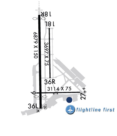
| Lat: N 3002.5 Long: W 09001.7 Elev: 7 Var: -02 Longest Runway: 6879 | ||
| Clr Del: 127.4 Dept. ATIS: 124.9 Arr. ATIS: 124.9 AWOS: 124.9 Ground: 121.7 Tower: 118.95 | ||
| |||||||||||||||||||||||||||||||||||||||||||||||||||||||||||||||||||||
| |||||||||||||||||||||||||||||||||||||||||||||||||||||||||||||||||||||
| |||||||||||||||||||||||||||||||||||||||||||||||||||||||||||||||||||||
| |||||||||||||||||||||||||||||||||||||||||||||||||||||||||||||||||||||
| |||||||||||||||||||||||||||||||||||||||||||||||||||||||||||||||||||||
| FBOs at nearby airports who want your business: | |||||||||||
| |||||||||||
| |||||||||||
| Rwy | Rwy | |||||||
| 3114x75 | 3114' | 3114x75 | 3114' | |||||
| 3697x75 | 3697' | 3697x75 | 3697' | |||||
| 6879x150 | 6640' | 111.30 - 177° | 6879x150 | 6059' | ||||
| Runway ID | Single Wheel | Double Wheel | Double Tandem Wheel | Dual Double Wheel |
| 09/27 | 50,000 | 80,000 | 100,000 | N/A |
| 18L/36R | 35,000 | 55,000 | 80,000 | N/A |
| 18R/36L | 60,000 | 175,000 | 200,000 | 350,000 |
| These numbers are Advisory and are not limits. The Airport Manager should have more accurate Weight Limits | ||||
 Airport Diagram might not be current. | |
| Facility Name: | LAKEFRONT |
| City Name: | NEW ORLEANS |
| County: | ORLEANS |
| State abbrev: | LA |
| State Name: | LOUISIANA |
| Ownership: | PUBLICLY OWNED |
| Use: | OPEN TO THE PUBLIC |
| Owner's Name: | ORLEANS LEVEE DISTRICT |
| Address: | 6001 STARS AND STRIPES BLVD, SUITE 204 |
| NEW ORLEANS, LA 70126 | |
| Owner's Phone: | 504-243-4010 |
| Manager's Name: | BRUCE MARTIN |
| Address: | 6001 STARS & STRIPES BLVD, SUITE 204 |
| NEW ORLEANS, LA 70126 | |
| Phone: | 504-243-4010 |
| FAA Region: | SOUTHWEST |
| FAA Field Office: | LNM |

| Date | Sunrise | Sunset |
|---|---|---|
| 02/06/25 Thursday | 6:47 | 17:41 |
| 02/07/25 Friday | 6:47 | 17:42 |
| 02/08/25 Saturday | 6:46 | 17:43 |
| 02/09/25 Sunday | 6:45 | 17:44 |
| 02/10/25 Monday | 6:44 | 17:45 |
| 02/11/25 Tuesday | 6:44 | 17:46 |
| 02/12/25 Wednesday | 6:43 | 17:46 |
| 02/13/25 Thursday | 6:42 | 17:47 |
| 02/14/25 Friday | 6:41 | 17:48 |
| 02/15/25 Saturday | 6:40 | 17:49 |
| 02/16/25 Sunday | 6:39 | 17:50 |
| 02/17/25 Monday | 6:38 | 17:50 |
| 02/18/25 Tuesday | 6:38 | 17:51 |
| 02/19/25 Wednesday | 6:37 | 17:52 |
| Airport Attendance Schedule | CONTINUOUS |
| Airport Status | OPERATIONAL (This Status can change at any time - please check NOTAMS) |
| Airport Lighting Schedule | WHEN TWR CLSD ACTVT MALSR RWY 18R; MIRL RWY 18R/36L; TWY B, C, D, E, F, H, EAST HNGRLN - PRESET LOW INTST. ACTVT 5 CLICKS FOR MED AND 7 CLICKS FOR HIGH - CTAF.; FOR ARPT BCN CTC ATCT. |
| Airport Storage Available | Tie Downs, Hanger |
| Extra Services Available | Air Ambulance, Avionics, Charter, Flight Instruction, Aircraft Rental, Aircraft Sales |
| Wind Indicator | YES - (lighted) |
| Control Tower | YES |
| CTAF Frequency | 118.950 |
| Unicom Frequency | |
| Rotating Beacon Color | WG |
| Segmented Circle | YES |
| Landing Fee | NO |
| Airport Inspected | FEDERAL - performed by STATE AERONAUTICAL PERSONNEL |
| Inspection Date | 07/11/2023 |
| Type of Fuel Available | Grade 100LL, JET A (freeze point -40C) |
| Airframe Repair Service | MAJOR |
| Power Plant Repair Service | MAJOR |
| Latitude | N3002.5 |
| Longitude | W09001.7 (ESTIMATED) |
| Arpt Elevation | 7ft (SURVEYED) |
| Magnetic Variation | 02E |
| 4 miles NE | of NEW ORLEANS |
| Traffic Pattern Altitude | |
| Sectional Chart | NEW ORLEANS |
| Operations (Reported) | Yearly | Avg. Daily |
|---|---|---|
| General Aviation Transient | 0 | 0 |
| General Aviation Local | 0 | 0 |
| Air Taxi | 0 | 0 |
| Commerical | 0 | 0 |
| Commuter | 0 | 0 |
| Military | 0 | 0 |
| Aircraft based on Field | |
|---|---|
| General Aviation Singles | 0 |
| General Aviation Multi | 0 |
| Jet Aircraft | 0 |
| General Aviation Helicopters | 0 |
| Military Aircraft | 0 |
| Gliders | 0 |
| Ultralights | 0 |
| FSS on field | NO |
| FSS tie-in | DE RIDDER |
| FSS Phone | 1-800-WX-BRIEF |
| Who issues Notams | NEW |
| Notam D service at airport | YES |
| ARTCC Name | HOUSTON |
| Airport Certification | |
| Aircraft Rescue & Firefighting Index | FOR FICONS AFTER HRS CALL ARFF 504-606-9264.; ARFF CPBLTY EQUIVALENT TO INDEX B. |
| Airport of Entry | No |
| Custom Landing Rights | YES |
| Joint Civil/Military | No |
| Military Landing rights | YES |
| NATIONAL PLAN OF INTEGRATED AIRPORT SYSTEMS (NPIAS) |
| GRANT AGREEMENTS UNDER FAAP/ADAP/AIP |
| SURPLUS PROPERTY AGREEMENT UNDER PUBLIC LAW 289 |
| ASSURANCES PURSUANT TO TITLE VI, CIVIL RIGHTS ACT OF 1964 |
| AGREEMENT UNDER DLAND OR DCLA HAS EXPIRED. |
| PPR REQUIRED FOR ACFT TRNSPG ANY ITEMS LISTED IN PART 175 TITLE 49. CONTACT 504-606-9264 |
| TWY A UNEVEN PAVEMENT. |
| FOR ASSTNC AFTER 2100 LOCAL CTC AMGR 504-874-0459 |
| FOR FICONS AFTER HRS CALL ARFF 504-606-9264. |
| BOAT MASTS UP TO 80 FT WI 0.5NM OF AER RWY 27. |
| ARPT WINDCONE FOR BALL PARK RAMP LGTS OTS PERMLY. |
| CAUTION TWY F BTN TRML RAMP AND FLT LN FST RAMP IREG SFC. |
| FOR CD WHEN ATCT IS CLSD CTC MSY APCH AT 504-471-4350 OR 127.4 |
| BIRDS ON & INVOF ARPT. |
| BOATS AS HIGH AS 80 FT PASS WI 400 FT OF RWY 09 THLD. |
| ARFF CPBLTY EQUIVALENT TO INDEX B. |
| FUEL NOT AVAILABLE WITHIN 100' OF TERMINAL BUILDING |
| RWY 18R/ 36LFEW LOW SPOTS NEAR INTERSECTION OF RY 09/27-HOLDING WATER. |
Airport Communications & Frequencies:
| |||||||||||||||||||||||||||||||||||
| Runway: 09 | Runway: 27 | ||
| Mag heading: | 87° | Mag heading: | 267° |
| Rwy Slope: | -.01% Down | Rwy Slope: | .01% Up |
| Approach: | Approach: | ||
| Pattern: | Left Traffic | Pattern: | Right Traffic |
| Markings: | BASIC | Markings: | BASIC |
| Marking Condition: | GOOD | Marking Condition: | FAIR |
| Arresting Dev: | Arresting Dev: | ||
| Lat & Long: | N3002.2 W09001.8 | Lat. & Long.: | N3002.2 W09001.2 |
| Elev: | 4.9 ft. MSL | Elev: | 4.7 ft. MSL |
| TCH: | 40 ft. AGL | TCH: | 43 ft. AGL |
| Visual Glide Path: | 3.00 degrees | Visual Glide Path: | 3.20 degrees |
| Displaced Threshold: | No | Displaced Threshold: | No |
| Touchdown Zone: | YES | Touchdown Zone: | YES |
| Touchdown Elev.: | 6.9 feet | Touchdown Elev.: | 6.9 feet |
| Visual Glide Slope: | 4-Light PAPI on LEFT side of Runway | Visual Glide Slope: | 4-Light PAPI on RIGHT side of Runway |
| RVR Equipment: | RVR Equipment: | ||
| RVV Equipment: | NO | RVV Equipment: | NO |
| Approach Lights: | Approach Lights: | ||
| REIL: | YES | REIL: | NO |
| Centerline Lights: | NO | Centerline Lights: | NO |
| Touchdown lights: | NO | Touchdown lights: | NO |
| Runway Category: | Runway with a Visual Approach | Runway Category: | Runway with a Visual Approach |
| Declared Distances: | TORA:3113' TODA:3113' ASDA:3113' LDA:3113' | Declared Distances: | TORA:3113' TODA:3113' ASDA:3113' LDA:3113' |
| Obstructions: | BERM | Obstructions: | ROAD |
| Marked: | LIGHTED | Marked: | NOT Marked/Lighted |
| Clearance slope: | 16:1 | Clearance slope: | 24:1 |
| Obstruction height: | 4 feet AGL | Obstruction height: | 14 feet AGL |
| Dist. from runway: | 267 feet | Dist. from runway: | 543 feet |
| Centerline offset: | Centerline offset: | 161 feet right of centerline | |
| Comments: | Comments: |
| Runway: 18L | Runway: 36R | ||
| Mag heading: | 177° | Mag heading: | 357° |
| Rwy Slope: | .04% Up | Rwy Slope: | -.04% Down |
| Approach: | Approach: | ||
| Pattern: | Left Traffic | Pattern: | Right Traffic |
| Markings: | BASIC | Markings: | BASIC |
| Marking Condition: | GOOD | Marking Condition: | GOOD |
| Arresting Dev: | Arresting Dev: | ||
| Lat & Long: | N3003.0 W09001.7 | Lat. & Long.: | N3002.4 W09001.7 |
| Elev: | 5.2 ft. MSL | Elev: | 6.7 ft. MSL |
| TCH: | TCH: | 45 ft. AGL | |
| Visual Glide Path: | Visual Glide Path: | 3.00 degrees | |
| Displaced Threshold: | No | Displaced Threshold: | No |
| Touchdown Zone: | YES | Touchdown Zone: | YES |
| Touchdown Elev.: | 6.6 feet | Touchdown Elev.: | 6.8 feet |
| Visual Glide Slope: | Visual Glide Slope: | 4-Light PAPI on LEFT side of Runway; RWY 36R PAPI UNUSBL BTN 2100 AND 0700 LOCAL | |
| RVR Equipment: | RVR Equipment: | ||
| RVV Equipment: | NO | RVV Equipment: | NO |
| Approach Lights: | Approach Lights: | ||
| REIL: | YES | REIL: | YES |
| Centerline Lights: | NO | Centerline Lights: | NO |
| Touchdown lights: | NO | Touchdown lights: | NO |
| Runway Category: | Runway with a Visual Approach | Runway Category: | Runway with a Visual Approach |
| Declared Distances: | TORA:3697' TODA:3697' ASDA:3697' LDA:3697' | Declared Distances: | TORA:3697' TODA:3697' ASDA:3697' LDA:3697' |
| Obstructions: | Obstructions: | BLDG | |
| Marked: | Marked: | LIGHTED | |
| Clearance slope: | 50:1 | Clearance slope: | 33:1 |
| Obstruction height: | Obstruction height: | 54 feet AGL | |
| Dist. from runway: | Dist. from runway: | 2035 feet | |
| Centerline offset: | Centerline offset: | 35 feet left of centerline | |
| Comments: | Comments: |
| Runway: 18R | Runway: 36L | ||
| Mag heading: | 177° | Mag heading: | 357° |
| Rwy Slope: | .00% | Rwy Slope: | .00% |
| Approach: | ILS/DME | Approach: | |
| Pattern: | Right Traffic | Pattern: | Left Traffic |
| Markings: | PRECISION INSTRUMENT | Markings: | NONPRECISION INSTRUMENT |
| Marking Condition: | GOOD | Marking Condition: | GOOD |
| Arresting Dev: | Arresting Dev: | ||
| Lat & Long: | N3003.2 W09001.8 | Lat. & Long.: | N3002.0 W09001.8 |
| Elev: | 5.7 ft. MSL | Elev: | 5.7 ft. MSL |
| TCH: | 51 ft. AGL | TCH: | 50 ft. AGL |
| Visual Glide Path: | 3.00 degrees | Visual Glide Path: | 3.00 degrees |
| Displaced Threshold: | 239 feet | Displaced Threshold: | 820 feet |
| Touchdown Zone: | YES | Touchdown Zone: | YES |
| Touchdown Elev.: | 7.3 feet | Touchdown Elev.: | 7.3 feet |
| Visual Glide Slope: | 4-Light PAPI on LEFT side of Runway | Visual Glide Slope: | 4-Light PAPI on LEFT side of Runway |
| RVR Equipment: | RVR Equipment: | ||
| RVV Equipment: | NO | RVV Equipment: | NO |
| Approach Lights: | MALSR - 1,400 foot medium intensity approach lighting system with runway alignment indicator lights | Approach Lights: | |
| REIL: | NO | REIL: | YES |
| Centerline Lights: | NO | Centerline Lights: | NO |
| Touchdown lights: | NO | Touchdown lights: | NO |
| Runway Category: | Precision Instrument Runway | Runway Category: | Runway with a Non-precision Approach having visibility minimums greater than 3/4 mile |
| Declared Distances: | TORA:6880' TODA:6880' ASDA:6035' LDA:5510' | Declared Distances: | TORA:6880' TODA:6880' ASDA:5955' LDA:5135' |
| Obstructions: | OTHER; PIER. | Obstructions: | BERM |
| Marked: | LIGHTED | Marked: | NOT Marked/Lighted |
| Clearance slope: | 16:1; APCH RATIO 50:1 FM DSPLCD THR. | Clearance slope: | APCH RATIO 32:1 AT DSPLCD THR; +77' SILO 2500'; 580' R. |
| Obstruction height: | 6 feet AGL | Obstruction height: | 7 feet AGL |
| Dist. from runway: | 300 feet | Dist. from runway: | 200 feet |
| Centerline offset: | Centerline offset: | ||
| Comments: | Comments: | +7 FT WALL 150 FT FM RY END. |
Thanks for using FltPlan.com
all rights reserved © 1999-2025 by Flight Plan LLC