| OCALA INTL/TAYLOR FIELD OCALA FL |
| |
| Lat: N 2910.3 Long: W 08213.4 Elev: 90 Var: +04 Longest Runway: 7467 | ||
| Dept. ATIS: 128.12 Arr. ATIS: 128.12 AWOS: 128.12 Ground: 121.4 Tower: 119.25 | ||
| |||||||||||||||||||||||||||||||
| |||||||||||||||||||||||||||||||
| |||||||||||||||||||||||||||||||
| Rwy | Rwy | |||||||
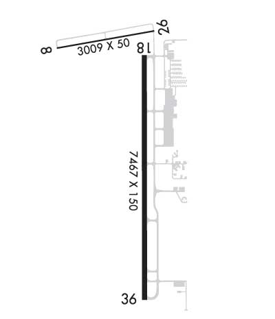
| 3009x50 | 3009' | 3009x50 | 3009' | |||||
| 7467x150 | 7307' | 7467x150 | 6906' | 111.50 - 003° | ||||
| Runway ID | Single Wheel | Double Wheel | Double Tandem Wheel | Dual Double Wheel |
| 08/26 | 30,000 | N/A | N/A | N/A |
| 18/36 | 60,000 | 125,000 | 220,000 | N/A |
| These numbers are Advisory and are not limits. The Airport Manager should have more accurate Weight Limits | ||||
 Airport Diagram might not be current. | |
| Facility Name: | OCALA INTL-JIM TAYLOR FLD |
| City Name: | OCALA |
| County: | MARION |
| State abbrev: | FL |
| State Name: | FLORIDA |
| Ownership: | PUBLICLY OWNED |
| Use: | OPEN TO THE PUBLIC |
| Owner's Name: | CITY OF OCALA |
| Address: | 1770 SW 60TH AVENUE, SUITE 600 |
| OCALA, FL 34474 | |
| Owner's Phone: | 352-629-8377 |
| Manager's Name: | MATTHEW GROW |
| Address: | 1770 SW 60TH AVE, SUITE 600 |
| OCALA, FL 34474 | |
| Phone: | 352-629-8377 |
| FAA Region: | SOUTHERN |
| FAA Field Office: | ORL |

| Date | Sunrise | Sunset |
|---|---|---|
| 09/24/21 Friday | 7:18 | 19:23 |
| 09/25/21 Saturday | 7:19 | 19:22 |
| 09/26/21 Sunday | 7:19 | 19:21 |
| 09/27/21 Monday | 7:20 | 19:20 |
| 09/28/21 Tuesday | 7:20 | 19:18 |
| 09/29/21 Wednesday | 7:21 | 19:17 |
| 09/30/21 Thursday | 7:21 | 19:16 |
| 10/01/21 Friday | 7:22 | 19:15 |
| 10/02/21 Saturday | 7:22 | 19:14 |
| 10/03/21 Sunday | 7:23 | 19:12 |
| 10/04/21 Monday | 7:24 | 19:11 |
| 10/05/21 Tuesday | 7:24 | 19:10 |
| 10/06/21 Wednesday | 7:25 | 19:09 |
| 10/07/21 Thursday | 7:25 | 19:08 |
| Airport Attendance Schedule | 7 Days A Week 0600-2100; SVC AFT HR - 352-682-3911. |
| Airport Status | OPERATIONAL (This Status can change at any time - please check NOTAMS) |
| Airport Lighting Schedule | WHEN ATCT CLSD ACTVT MALSR RWY 36; PAPI RWY 18 & 36; HIRL RWY 18/36 - CTAF. |
| Airport Storage Available | Tie Downs, Hanger |
| Extra Services Available | Avionics, Charter, Flight Instruction, Aircraft Rental, Aircraft Sales |
| Wind Indicator | YES - (lighted) |
| Control Tower | YES |
| CTAF Frequency | 119.250 |
| Unicom Frequency | |
| Rotating Beacon Color | CLEAR-GREEN (Light Land Airport) |
| Segmented Circle | YES |
| Landing Fee | NO; FEE FOR ACR OPS ONLY. |
| Airport Inspected | FEDERAL - performed by FAA AIRPORTS FIELD PERSONNEL |
| Inspection Date | 11/22/2019 |
| Type of Fuel Available | Grade 100LL, JET A-1 (icing inhibitor, freeze point -50C) |
| Airframe Repair Service | MAJOR |
| Power Plant Repair Service | MAJOR |
| Latitude | N2910.3 |
| Longitude | W08213.4 (ESTIMATED) |
| Arpt Elevation | 89ft (SURVEYED) |
| Magnetic Variation | 04W |
| 4 miles W | of OCALA |
| Traffic Pattern Altitude | |
| Sectional Chart | JACKSONVILLE |
| Operations (Reported) | Yearly | Avg. Daily |
|---|---|---|
| General Aviation Transient | 38930 | 107 |
| General Aviation Local | 21106 | 58 |
| Air Taxi | 1810 | 5 |
| Commerical | 31 | 0 |
| Commuter | 0 | 0 |
| Military | 644 | 2 |
| Aircraft based on Field | |
|---|---|
| General Aviation Singles | 111 |
| General Aviation Multi | 19 |
| Jet Aircraft | 11 |
| General Aviation Helicopters | 11 |
| Military Aircraft | 0 |
| Gliders | 1 |
| Ultralights | 0 |
| FSS on field | NO |
| FSS tie-in | GAINESVILLE |
| FSS Phone | 1-800-WX-BRIEF |
| Who issues Notams | OCF |
| Notam D service at airport | YES |
| ARTCC Name | JACKSONVILLE |
| Airport Certification | INDEX B UPON REQUEST; CLSD TO ACR OPS WITH MORE THAN 30 PAX SEATS EXC PPR - AMGR. |
| Aircraft Rescue & Firefighting Index | AIRPORT HAS A CERTIFICATE UNDER CFR PART 139 |
| Airport of Entry | No |
| Custom Landing Rights | No |
| Joint Civil/Military | No |
| Military Landing rights | YES |
| NATIONAL PLAN OF INTEGRATED AIRPORT SYSTEMS (NPIAS) |
| GRANT AGREEMENTS UNDER FAAP/ADAP/AIP |
| ASSURANCES PURSUANT TO TITLE VI, CIVIL RIGHTS ACT OF 1964 |
| TWY A1 RSTRD TO ACFT WITH WINGSPAN 60 FT OR LESS. |
| OBJECT 2.5 FT AGL LCTD 39 FT NORTH OF TWY A1 CNTRLN. |
| ACFT DEP RWY 18 MNTN RWY HDG TO 800 FT AGL OR TIL RCHG END OF RWY WHICHEVER OCRS LTR BFR MAKING LEFT TURNS. |
| TWY A1, A8, A9 & A12 E OF TWY A; TWY A NORTH OF TWY A2; CLSD TO ACR. |
| CUSTOM SVC UNAVBL. |
| SFC CONDS NOT RPRTD 1700-0700L. |
| FOR CD IF UNA TO CTC ON FSS FREQ, CTC JACKSONVILLE APCH AT 904-741-0284. |
| RWY 08/2 6 RWY 8/26 NOT AVBL FOR SKED ACR OPNS WITH MORE THAN 9 PAX SEATS OR UNSKED ACR AT LEAST 31 PAX SEATS. |
| RWY 36 CALM WIND RWY. |
Airport Communications & Frequencies:
| ||||||||||||||||||
| Runway: 08 | Runway: 26 | ||
| Mag heading: | 84° | Mag heading: | 264° |
| Rwy Slope: | .03% Up | Rwy Slope: | -.03% Down |
| Approach: | Approach: | ||
| Pattern: | Left Traffic | Pattern: | Left Traffic |
| Markings: | BASIC | Markings: | BASIC |
| Marking Condition: | FAIR | Marking Condition: | FAIR |
| Arresting Dev: | Arresting Dev: | ||
| Lat & Long: | N2910.8 W08213.9 | Lat. & Long.: | N2910.9 W08213.3 |
| Elev: | 86.9 ft. MSL | Elev: | 87.8 ft. MSL |
| TCH: | TCH: | ||
| Visual Glide Path: | Visual Glide Path: | ||
| Displaced Threshold: | No | Displaced Threshold: | No |
| Touchdown Zone: | YES | Touchdown Zone: | YES |
| Touchdown Elev.: | 89.7 feet | Touchdown Elev.: | 89.7 feet |
| Visual Glide Slope: | Visual Glide Slope: | ||
| RVR Equipment: | RVR Equipment: | ||
| RVV Equipment: | NO | RVV Equipment: | NO |
| Approach Lights: | Approach Lights: | ||
| REIL: | NO | REIL: | NO |
| Centerline Lights: | NO | Centerline Lights: | NO |
| Touchdown lights: | NO | Touchdown lights: | NO |
| Runway Category: | Runway with a Visual Approach | Runway Category: | Runway with a Visual Approach |
| Declared Distances: | Declared Distances: | ||
| Obstructions: | TREES | Obstructions: | PLINE |
| Marked: | NOT Marked/Lighted | Marked: | NOT Marked/Lighted |
| Clearance slope: | 20:1 | Clearance slope: | 34:1 |
| Obstruction height: | 50 feet AGL | Obstruction height: | 25 feet AGL |
| Dist. from runway: | 1205 feet | Dist. from runway: | 1045 feet |
| Centerline offset: | 105 left of centerline | Centerline offset: | 170 feet left of centerline |
| Comments: | Comments: |
| Runway: 18 | Runway: 36 | ||
| Mag heading: | 184° | Mag heading: | 4° |
| Rwy Slope: | -.03% Down | Rwy Slope: | .03% Up |
| Approach: | Approach: | ILS | |
| Pattern: | Left Traffic | Pattern: | Left Traffic |
| Markings: | PRECISION INSTRUMENT | Markings: | PRECISION INSTRUMENT |
| Marking Condition: | FAIR | Marking Condition: | FAIR |
| Arresting Dev: | Arresting Dev: | ||
| Lat & Long: | N2910.7 W08213.4 | Lat. & Long.: | N2909.5 W08213.4 |
| Elev: | 80.1 ft. MSL | Elev: | 78.0 ft. MSL |
| TCH: | 45 ft. AGL | TCH: | 45 ft. AGL |
| Visual Glide Path: | 3.00 degrees | Visual Glide Path: | 3.00 degrees |
| Displaced Threshold: | 160 feet | Displaced Threshold: | 561 feet |
| Touchdown Zone: | YES | Touchdown Zone: | YES |
| Touchdown Elev.: | 80.3 feet | Touchdown Elev.: | 80.1 feet |
| Visual Glide Slope: | 4-Light PAPI on LEFT side of Runway | Visual Glide Slope: | 4-Light PAPI on LEFT side of Runway |
| RVR Equipment: | RVR Equipment: | ||
| RVV Equipment: | NO | RVV Equipment: | NO |
| Approach Lights: | Approach Lights: | MALSR - 1,400 foot medium intensity approach lighting system with runway alignment indicator lights | |
| REIL: | NO | REIL: | NO |
| Centerline Lights: | NO | Centerline Lights: | NO |
| Touchdown lights: | NO | Touchdown lights: | NO |
| Runway Category: | Precision Instrument Runway | Runway Category: | Precision Instrument Runway |
| Declared Distances: | TORA:7467' TODA:7467' ASDA:6717' LDA:6557' | Declared Distances: | TORA:7195' TODA:7195' ASDA:6907' LDA:6347' |
| Obstructions: | TREES | Obstructions: | TREE |
| Marked: | NOT Marked/Lighted | Marked: | NOT Marked/Lighted |
| Clearance slope: | 40:1 | Clearance slope: | 50:1 |
| Obstruction height: | 60 feet AGL | Obstruction height: | 46 feet AGL |
| Dist. from runway: | 2600 feet | Dist. from runway: | 2530 feet |
| Centerline offset: | 530 right of centerline | Centerline offset: | 410 feet right of centerline |
| Comments: | Comments: |
Thanks for using FltPlan.com
all rights reserved © 1999-2021 by Flight Plan LLC