
| OTTUMWA RGNL OTTUMWA IA |
| |
| Lat: N 4106.4 Long: W 09226.8 Elev: 846 Var: +01 Longest Runway: 6001 | ||
| AWOS: 124.17 CTAF: 123.0 | ||
| ||||||||||||||||||||||||||||||||||||||||||||
| ||||||||||||||||||||||||||||||||||||||||||||
| ||||||||||||||||||||||||||||||||||||||||||||
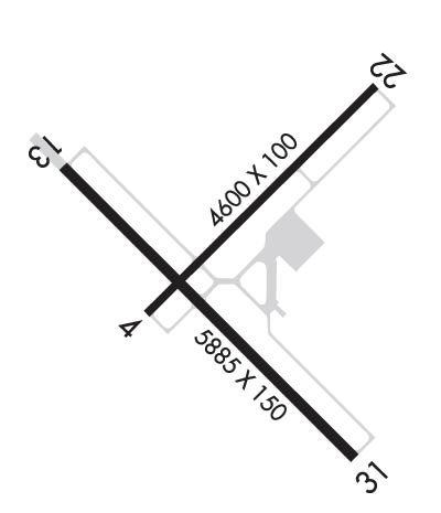
| Rwy | Rwy | |||||||
| 4601x100 | 4601' | 4601x100 | 4601' | |||||
| 6001x100 | 6001' | 6001x100 | 6001' | 109.50 - 315° | ||||
| Runway ID | Single Wheel | Double Wheel | Double Tandem Wheel | Dual Double Wheel |
| 04/22 | 42,000 | 65,000 | 120,000 | N/A |
| 13/31 | 80,000 | 105,000 | 175,000 | N/A |
| These numbers are Advisory and are not limits. The Airport Manager should have more accurate Weight Limits | ||||
 Airport Diagram might not be current. | |
| Facility Name: | OTTUMWA RGNL |
| City Name: | OTTUMWA |
| County: | WAPELLO |
| State abbrev: | IA |
| State Name: | IOWA |
| Ownership: | PUBLICLY OWNED |
| Use: | OPEN TO THE PUBLIC |
| Owner's Name: | CITY OF OTTUMWA |
| Address: | CITY HALL |
| OTTUMWA, IA 52501 | |
| Owner's Phone: | 641-683-0619 |
| Manager's Name: | JAY WHEATON |
| Address: | 14802 TERMINAL ST |
| OTTUMWA, IA 52501 | |
| Phone: | 641-683-0619 |
| FAA Region: | CENTRAL |
| FAA Field Office: | NONE |
| Date | Sunrise | Sunset |
|---|---|---|
| 12/12/25 Friday | 7:26 | 16:41 |
| 12/13/25 Saturday | 7:26 | 16:42 |
| 12/14/25 Sunday | 7:27 | 16:42 |
| 12/15/25 Monday | 7:28 | 16:42 |
| 12/16/25 Tuesday | 7:29 | 16:42 |
| 12/17/25 Wednesday | 7:29 | 16:43 |
| 12/18/25 Thursday | 7:30 | 16:43 |
| 12/19/25 Friday | 7:30 | 16:43 |
| 12/20/25 Saturday | 7:31 | 16:44 |
| 12/21/25 Sunday | 7:32 | 16:44 |
| 12/22/25 Monday | 7:32 | 16:45 |
| 12/23/25 Tuesday | 7:32 | 16:45 |
| 12/24/25 Wednesday | 7:33 | 16:46 |
| 12/25/25 Thursday | 7:33 | 16:47 |
| Airport Attendance Schedule | 7 Days A Week 0700-2000; FOR ATTENDANT AFT HRS CALL 641-799-9120 OR 641-208-5821. |
| Airport Status | OPERATIONAL (This Status can change at any time - please check NOTAMS) |
| Airport Lighting Schedule | ACTVT MALSR RWY 31; REIL RWY 04, 22 & 13; PAPI RWY 04, 13 & 22; HIRL RWY 13/31 & RWY 04/22 - CTAF. |
| Airport Storage Available | Tie Downs, Hanger |
| Extra Services Available | Charter, Flight Instruction, Aircraft Rental |
| Wind Indicator | YES - (lighted) |
| Control Tower | NO |
| CTAF Frequency | 123.000 |
| Unicom Frequency | 123.000 |
| Rotating Beacon Color | WG |
| Segmented Circle | NO |
| Landing Fee | NO |
| Airport Inspected | FEDERAL - performed by STATE AERONAUTICAL PERSONNEL |
| Inspection Date | 05/10/2024 |
| Type of Fuel Available | Grade 100LL, JET A (freeze point -40C) |
| Airframe Repair Service | MAJOR |
| Power Plant Repair Service | MAJOR |
| Latitude | N4106.4 |
| Longitude | W09226.8 (ESTIMATED) |
| Arpt Elevation | 845ft (SURVEYED) |
| Magnetic Variation | 01W |
| 5 miles NW | of OTTUMWA |
| Traffic Pattern Altitude | |
| Sectional Chart | CHICAGO |
| Operations (Reported) | Yearly | Avg. Daily |
|---|---|---|
| General Aviation Transient | 0 | 0 |
| General Aviation Local | 0 | 0 |
| Air Taxi | 0 | 0 |
| Commerical | 0 | 0 |
| Commuter | 0 | 0 |
| Military | 0 | 0 |
| Aircraft based on Field | |
|---|---|
| General Aviation Singles | 0 |
| General Aviation Multi | 0 |
| Jet Aircraft | 0 |
| General Aviation Helicopters | 0 |
| Military Aircraft | 0 |
| Gliders | 0 |
| Ultralights | 0 |
| FSS on field | NO |
| FSS tie-in | FORT DODGE |
| FSS Phone | 1-800-WX-BRIEF |
| Who issues Notams | OTM |
| Notam D service at airport | YES |
| ARTCC Name | CHICAGO |
| Airport Certification | |
| Aircraft Rescue & Firefighting Index | None |
| Airport of Entry | No |
| Custom Landing Rights | No |
| Joint Civil/Military | No |
| Military Landing rights | YES |
| NATIONAL PLAN OF INTEGRATED AIRPORT SYSTEMS (NPIAS) |
| GRANT AGREEMENTS UNDER FAAP/ADAP/AIP |
| SURPLUS PROPERTY AGREEMENT UNDER PUBLIC LAW 289 |
| ASSURANCES PURSUANT TO TITLE VI, CIVIL RIGHTS ACT OF 1964 |
| RY 31 IS PREFERRED CALM WIND RY. |
| REMOTE CTL ACFT OPNS IN AREA. |
| FOR CD IF UNA TO CTC ON FSS FREQ, CTC CHICAGO ARTCC AT 630-906-8921. |
Airport Communications & Frequencies:
| |||||||||
| Runway: 04 | Runway: 22 | ||
| Mag heading: | 46° | Mag heading: | 226° |
| Rwy Slope: | -.19% Down | Rwy Slope: | .19% Up |
| Approach: | Approach: | ||
| Pattern: | Left Traffic | Pattern: | Left Traffic |
| Markings: | NONPRECISION INSTRUMENT | Markings: | NONPRECISION INSTRUMENT |
| Marking Condition: | GOOD | Marking Condition: | GOOD |
| Arresting Dev: | Arresting Dev: | ||
| Lat & Long: | N4106.3 W09227.1 | Lat. & Long.: | N4106.8 W09226.4 |
| Elev: | 841.4 ft. MSL | Elev: | 832.7 ft. MSL |
| TCH: | 40 ft. AGL | TCH: | 41 ft. AGL |
| Visual Glide Path: | 3.00 degrees | Visual Glide Path: | 3.00 degrees |
| Displaced Threshold: | No | Displaced Threshold: | No |
| Touchdown Zone: | YES | Touchdown Zone: | YES |
| Touchdown Elev.: | 845.6 feet | Touchdown Elev.: | 845.6 feet |
| Visual Glide Slope: | 2-Light PAPI on LEFT side of Runway | Visual Glide Slope: | 2-Light PAPI on LEFT side of Runway |
| RVR Equipment: | RVR Equipment: | ||
| RVV Equipment: | NO | RVV Equipment: | NO |
| Approach Lights: | Approach Lights: | ||
| REIL: | YES | REIL: | YES |
| Centerline Lights: | NO | Centerline Lights: | NO |
| Touchdown lights: | NO | Touchdown lights: | NO |
| Runway Category: | Runway with a Visual Approach | Runway Category: | Runway with a Visual Approach |
| Declared Distances: | Declared Distances: |
| Runway: 13 | Runway: 31 | ||
| Mag heading: | 136° | Mag heading: | 316° |
| Rwy Slope: | -.03% Down | Rwy Slope: | .03% Up |
| Approach: | Approach: | ILS/DME | |
| Pattern: | Left Traffic | Pattern: | Left Traffic |
| Markings: | PRECISION INSTRUMENT | Markings: | PRECISION INSTRUMENT |
| Marking Condition: | GOOD | Marking Condition: | GOOD |
| Arresting Dev: | Arresting Dev: | ||
| Lat & Long: | N4106.7 W09227.4 | Lat. & Long.: | N4106.0 W09226.4 |
| Elev: | 840.0 ft. MSL | Elev: | 838.4 ft. MSL |
| TCH: | 40 ft. AGL | TCH: | |
| Visual Glide Path: | 3.00 degrees | Visual Glide Path: | |
| Displaced Threshold: | No | Displaced Threshold: | No |
| Touchdown Zone: | YES | Touchdown Zone: | YES |
| Touchdown Elev.: | 842.2 feet | Touchdown Elev.: | 842.2 feet |
| Visual Glide Slope: | 4-Light PAPI on LEFT side of Runway | Visual Glide Slope: | |
| RVR Equipment: | RVR Equipment: | ||
| RVV Equipment: | NO | RVV Equipment: | NO |
| Approach Lights: | Approach Lights: | MALSR - 1,400 foot medium intensity approach lighting system with runway alignment indicator lights | |
| REIL: | YES | REIL: | NO |
| Centerline Lights: | NO | Centerline Lights: | NO |
| Touchdown lights: | NO | Touchdown lights: | NO |
| Runway Category: | D | Runway Category: | Precision Instrument Runway |
| Declared Distances: | Declared Distances: |
Thanks for using FltPlan.com
all rights reserved © 1999-2025 by Flight Plan LLC