
| PORTLAND INTL JETPORT PORTLAND ME |
| |
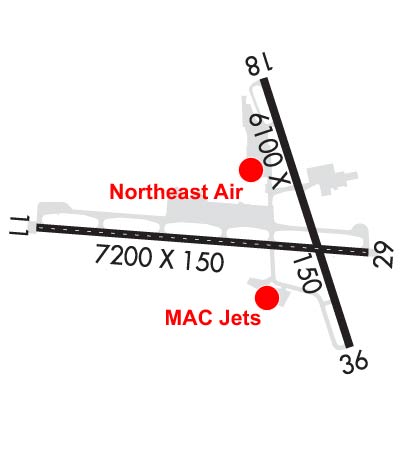
| Lat: N 4338.7 Long: W 07018.5 Elev: 76 Var: +15 Longest Runway: 7200 | ||
| Clr Del: 121.9 Dept. ATIS: 119.05 Arr. ATIS: 119.05 AWOS: 119.05 Ground: 121.9 Tower: 120.9 | ||
| |||||||||||||||||||||||||||||||||||||||||||||||||||||||||||||||||||||
| |||||||||||||||||||||||||||||||||||||||||||||||||||||||||||||||||||||
| |||||||||||||||||||||||||||||||||||||||||||||||||||||||||||||||||||||
| |||||||||||||||||||||||||||||||||||||||||||||||||||||||||||||||||||||
| |||||||||||||||||||||||||||||||||||||||||||||||||||||||||||||||||||||
| Rwy | Rwy | |||||||
| 7200x150 | 7200' | 109.90 - 110° | 7200x150 | 7200' | 109.90 - 290° | |||
| 6100x150 | 5650' | 6100x150 | 5600' | |||||
| Runway ID | Single Wheel | Double Wheel | Double Tandem Wheel | Dual Double Wheel |
| 11/29 | 75,000 | 169,000 | 300,000 | N/A |
| 18/36 | 75,000 | 165,000 | 300,000 | N/A |
| These numbers are Advisory and are not limits. The Airport Manager should have more accurate Weight Limits | ||||
 Airport Diagram might not be current. | |
| Facility Name: | PORTLAND INTL JETPORT |
| City Name: | PORTLAND |
| County: | CUMBERLAND |
| State abbrev: | ME |
| State Name: | MAINE |
| Ownership: | PUBLICLY OWNED |
| Use: | OPEN TO THE PUBLIC |
| Owner's Name: | CITY OF PORTLAND |
| Address: | CITY HALL, 389 CONGRESS ST |
| PORTLAND, ME 04101 | |
| Owner's Phone: | 207-874-8300 |
| Manager's Name: | PAUL BRADBURY |
| Address: | 1001 WESTBROOK ST. |
| PORTLAND, ME 04102 | |
| Phone: | 207-756-8310 |
| FAA Region: | NEW ENGLAND |
| FAA Field Office: | NONE |

| Date | Sunrise | Sunset |
|---|---|---|
| 09/24/21 Friday | 6:30 | 18:35 |
| 09/25/21 Saturday | 6:32 | 18:34 |
| 09/26/21 Sunday | 6:33 | 18:32 |
| 09/27/21 Monday | 6:34 | 18:30 |
| 09/28/21 Tuesday | 6:35 | 18:28 |
| 09/29/21 Wednesday | 6:36 | 18:26 |
| 09/30/21 Thursday | 6:37 | 18:25 |
| 10/01/21 Friday | 6:38 | 18:23 |
| 10/02/21 Saturday | 6:40 | 18:21 |
| 10/03/21 Sunday | 6:41 | 18:19 |
| 10/04/21 Monday | 6:42 | 18:17 |
| 10/05/21 Tuesday | 6:43 | 18:16 |
| 10/06/21 Wednesday | 6:44 | 18:14 |
| 10/07/21 Thursday | 6:45 | 18:12 |
| Airport Attendance Schedule | 7 Days A Week 0600-2200 |
| Airport Status | OPERATIONAL (This Status can change at any time - please check NOTAMS) |
| Airport Lighting Schedule | WHEN TWR CLSD ACTVT MALSR RWY 29; REIL RWY 18 & 36; TDZL RWY 11; CNTLN RWY 11/29; PAPI RWY 11, 29, 18 & 36; HIRL RWY 11/29; MIRL RWY 18/36 - CTAF. |
| Airport Storage Available | Tie Downs, Hanger |
| Extra Services Available | Air Freight, Avionics, Charter, Flight Instruction, Aircraft Rental, Aircraft Sales |
| Wind Indicator | YES - (lighted) |
| Control Tower | YES |
| CTAF Frequency | 120.900 |
| Unicom Frequency | 122.950 |
| Rotating Beacon Color | CLEAR-GREEN (Light Land Airport) |
| Segmented Circle | NO |
| Landing Fee | NO |
| Airport Inspected | FEDERAL - performed by FAA AIRPORTS FIELD PERSONNEL |
| Inspection Date | 06/04/2021 |
| Type of Fuel Available | Grade 100LL, JET A (freeze point -40C); -10FOR FUEL AFT HRS CALL 207-774-6318 FOR NE AIR, CALL 207-347-0445 FOR MAC JETS. |
| Airframe Repair Service | MAJOR |
| Power Plant Repair Service | MAJOR |
| Latitude | N4338.7 |
| Longitude | W07018.5 (ESTIMATED) |
| Arpt Elevation | 75ft (SURVEYED) |
| Magnetic Variation | 15W |
| 2 miles W | of PORTLAND |
| Traffic Pattern Altitude | |
| Sectional Chart | NEW YORK |
| Operations (Reported) | Yearly | Avg. Daily |
|---|---|---|
| General Aviation Transient | 3096 | 8 |
| General Aviation Local | 2166 | 6 |
| Air Taxi | 3710 | 10 |
| Commerical | 8099 | 22 |
| Commuter | 0 | 0 |
| Military | 58388 | 160 |
| Aircraft based on Field | |
|---|---|
| General Aviation Singles | 30 |
| General Aviation Multi | 3 |
| Jet Aircraft | 7 |
| General Aviation Helicopters | 1 |
| Military Aircraft | 0 |
| Gliders | 0 |
| Ultralights | 0 |
| FSS on field | NO |
| FSS tie-in | BANGOR |
| FSS Phone | 1-800-WX-BRIEF |
| Who issues Notams | PWM |
| Notam D service at airport | YES |
| ARTCC Name | BOSTON |
| Airport Certification | AIRPORT RECEIVING SCHEDULED AIR CARRIER SERVICE FROM CARRIERS CERTIFICATED BY THE CIVIL AERONAUTICS BOARD |
| Aircraft Rescue & Firefighting Index | AIRPORT HAS A CERTIFICATE UNDER CFR PART 139 |
| Airport of Entry | No |
| Custom Landing Rights | YES; GA CUST/IMG FAC LCTD AT CARGO APRON. ACFT ARRG/DEPG CUST MUST USE EXTREME CTN WHEN NAVIGATING ON THE CARGO APRON TO MINIMIZE JET BLAST EXPOSURE TO HNGRS & ACFT. |
| Joint Civil/Military | No |
| Military Landing rights | YES |
| NATIONAL PLAN OF INTEGRATED AIRPORT SYSTEMS (NPIAS) |
| GRANT AGREEMENTS UNDER FAAP/ADAP/AIP |
| ASSURANCES PURSUANT TO TITLE VI, CIVIL RIGHTS ACT OF 1964 |
| AGREEMENT UNDER DLAND OR DCLA HAS EXPIRED. |
| NO TGLS DURG SNOW REMOVAL. |
| BIRDS OCNLY ON & INVOF ARPT. |
| PUSHBACK ONTO TWY A RQRD FM TRML GATES 1-8, TWY C RQRD FM TRML GATE 1A. ACFT MAY NOT PUSH SHORT OF TWY A FM GATES 1-8 NOR SHORT OF TWY C FM GATE 1A. CTC GND 121.9. ADZ PUSHBACK OPR YOU HAVE ALPHA OR CHARLIE PRIOR TO PUSH. |
| FOR CD WHEN ATCT CLSD, CTC BOSTON ARTCC AT 603-879-6859. |
| PAEW ADJ TO RWYS NGTS; GND VEHICLES MONITOR 120.9 WHEN ATCT CLSD. |
| MAINT RUN-UPS RWY 29 RUN-UP AREA ONLY. PRIOR TO ANY RUN-UPS, OR FOR NOISE ABATEMENT INFO, CTC ARPT OPS CNTR ON FREQ 129.95 OR CALL AT 207-756-8310. |
| ACFT EMERGS BTN 0000-0545 CALL PORTLAND AIR RESCUE 207-874-8576. |
Airport Communications & Frequencies:
| |||||||||||||||||||||||||||||||||||||||||||||||||||||||||
| Runway: 11 | Runway: 29 | ||
| Mag heading: | 110° | Mag heading: | 290° |
| Rwy Slope: | -.47% Down | Rwy Slope: | .47% Up |
| Approach: | ILS/DME | Approach: | ILS/DME |
| Pattern: | Left Traffic | Pattern: | Left Traffic |
| Markings: | PRECISION INSTRUMENT | Markings: | PRECISION INSTRUMENT |
| Marking Condition: | GOOD | Marking Condition: | GOOD |
| Arresting Dev: | Arresting Dev: | ||
| Lat & Long: | N4338.8 W07019.6 | Lat. & Long.: | N4338.6 W07017.9 |
| Elev: | 75.7 ft. MSL | Elev: | 42.2 ft. MSL |
| TCH: | 52 ft. AGL | TCH: | 50 ft. AGL |
| Visual Glide Path: | 3.00 degrees | Visual Glide Path: | 3.00 degrees |
| Displaced Threshold: | No | Displaced Threshold: | No |
| Touchdown Zone: | YES | Touchdown Zone: | YES |
| Touchdown Elev.: | 75.7 feet | Touchdown Elev.: | 56.3 feet |
| Visual Glide Slope: | 4-Light PAPI on RIGHT side of Runway | Visual Glide Slope: | 4-Light PAPI on RIGHT side of Runway |
| RVR Equipment: | TOUCHDOWN-MIDFIELD-ROLLOUT | RVR Equipment: | TOUCHDOWN-MIDFIELD-ROLLOUT |
| RVV Equipment: | YES | RVV Equipment: | YES |
| Approach Lights: | ALSF2 - standard 2,400 foot high intensity approach lighting system with sequenced flashers, Category II or III; ALSF-II BECOMES SSALS WHEN ATCT CLSD. | Approach Lights: | MALSR - 1,400 foot medium intensity approach lighting system with runway alignment indicator lights |
| REIL: | NO | REIL: | NO |
| Centerline Lights: | YES | Centerline Lights: | YES |
| Touchdown lights: | YES | Touchdown lights: | NO |
| Runway Category: | Precision Instrument Runway | Runway Category: | Precision Instrument Runway |
| Declared Distances: | TORA:7200' TODA:7200' ASDA:7200' LDA:7200' | Declared Distances: | TORA:7200' TODA:7200' ASDA:7200' LDA:7200' |
| Obstructions: | TREES | Obstructions: | TREE |
| Marked: | NOT Marked/Lighted | Marked: | NOT Marked/Lighted |
| Clearance slope: | 43:1 | Clearance slope: | 37:1 |
| Obstruction height: | 42 feet AGL | Obstruction height: | 166 feet AGL |
| Dist. from runway: | 2000 feet | Dist. from runway: | 6400 feet |
| Centerline offset: | 675 right of centerline | Centerline offset: | 1100 feet right of centerline |
| Comments: | Comments: |
| Runway: 18 | Runway: 36 | ||
| Mag heading: | 178° | Mag heading: | 358° |
| Rwy Slope: | -.01% Down | Rwy Slope: | .01% Up |
| Approach: | Approach: | ||
| Pattern: | Left Traffic | Pattern: | Left Traffic |
| Markings: | NONPRECISION INSTRUMENT | Markings: | NONPRECISION INSTRUMENT |
| Marking Condition: | GOOD | Marking Condition: | GOOD |
| Arresting Dev: | Arresting Dev: | ||
| Lat & Long: | N4339.3 W07018.4 | Lat. & Long.: | N4338.3 W07018.0 |
| Elev: | 44.8 ft. MSL | Elev: | 44.3 ft. MSL |
| TCH: | 50 ft. AGL | TCH: | 54 ft. AGL |
| Visual Glide Path: | 3.00 degrees | Visual Glide Path: | 3.25 degrees |
| Displaced Threshold: | 450 feet | Displaced Threshold: | 500 feet |
| Touchdown Zone: | YES | Touchdown Zone: | YES |
| Touchdown Elev.: | 50.4 feet | Touchdown Elev.: | 48.9 feet |
| Visual Glide Slope: | 4-Light PAPI on LEFT side of Runway | Visual Glide Slope: | 4-Light PAPI on LEFT side of Runway |
| RVR Equipment: | RVR Equipment: | ||
| RVV Equipment: | NO | RVV Equipment: | NO |
| Approach Lights: | Approach Lights: | ||
| REIL: | YES | REIL: | YES |
| Centerline Lights: | NO | Centerline Lights: | NO |
| Touchdown lights: | NO | Touchdown lights: | NO |
| Runway Category: | Runway with a Non-precision Approach having visibility minimums greater than 3/4 mile | Runway Category: | Runway with a Non-precision Approach having visibility minimums greater than 3/4 mile |
| Declared Distances: | TORA:6100' TODA:6100' ASDA:5600' LDA:5150' | Declared Distances: | TORA:6100' TODA:6100' ASDA:5650' LDA:5150' |
| Obstructions: | TREE | Obstructions: | TREE |
| Marked: | NOT Marked/Lighted | Marked: | NOT Marked/Lighted |
| Clearance slope: | 20:1 | Clearance slope: | 18:1 |
| Obstruction height: | 20 feet AGL | Obstruction height: | 60 feet AGL |
| Dist. from runway: | 600 feet | Dist. from runway: | 1300 feet |
| Centerline offset: | 60 right of centerline | Centerline offset: | 300 feet left of centerline |
| Comments: | Comments: |
Thanks for using FltPlan.com
all rights reserved © 1999-2021 by Flight Plan LLC