
| SCOTTSDALE SCOTTSDALE AZ |
| |
| Lat: N 3337.4 Long: W 11154.6 Elev: 1510 Var: -12 Longest Runway: 8249 | ||
| Clr Del: 124.8 Dept. ATIS: 118.6 Arr. ATIS: 118.6 Ground: 121.6 Tower: 119.9 | ||

| |||||||||||||||||||||||||||||||||||||||||||||||||||||||||||||||||||||
| |||||||||||||||||||||||||||||||||||||||||||||||||||||||||||||||||||||
| |||||||||||||||||||||||||||||||||||||||||||||||||||||||||||||||||||||
| |||||||||||||||||||||||||||||||||||||||||||||||||||||||||||||||||||||
| |||||||||||||||||||||||||||||||||||||||||||||||||||||||||||||||||||||
| |||||||||||||||||||||||||||||||||||||||||||||||||||||||||||||||||||||
| |||||||||||||||||||||||||||||||||||||||||||||||||||||||||||||||||||||
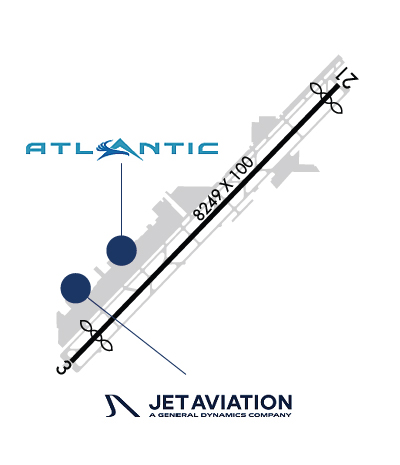
| FBOs at nearby airports who want your business: | |||||||||||||||||
| |||||||||||||||||
| Rwy | Rwy | |||||||
| 8249x100 | 7509' | 8249x100 | 7849' | |||||
| Runway ID | Single Wheel | Double Wheel | Double Tandem Wheel | Dual Double Wheel |
| 03/21 | 45,000 | 75,000 | N/A | N/A |
| These numbers are Advisory and are not limits. The Airport Manager should have more accurate Weight Limits | ||||
 Airport Diagram might not be current. | |
| Facility Name: | SCOTTSDALE |
| City Name: | SCOTTSDALE |
| County: | MARICOPA |
| State abbrev: | AZ |
| State Name: | ARIZONA |
| Ownership: | PUBLICLY OWNED |
| Use: | OPEN TO THE PUBLIC |
| Owner's Name: | CITY OF SCOTTSDALE |
| Address: | 3939 CIVIC CENTER PLAZA |
| SCOTTSDALE, AZ 85251 | |
| Owner's Phone: | 480-312-2321 |
| Manager's Name: | GARY MASCARO |
| Address: | 15000 N AIRPORT DR, SUITE 100 |
| SCOTTSDALE, AZ 85260 | |
| Phone: | 480-312-7735 |
| FAA Region: | WESTERN-PACIFIC |
| FAA Field Office: | PHX |
| Date | Sunrise | Sunset |
|---|---|---|
| 03/20/25 Thursday | 6:32 | 18:39 |
| 03/21/25 Friday | 6:30 | 18:40 |
| 03/22/25 Saturday | 6:29 | 18:41 |
| 03/23/25 Sunday | 6:28 | 18:41 |
| 03/24/25 Monday | 6:26 | 18:42 |
| 03/25/25 Tuesday | 6:25 | 18:43 |
| 03/26/25 Wednesday | 6:24 | 18:44 |
| 03/27/25 Thursday | 6:22 | 18:44 |
| 03/28/25 Friday | 6:21 | 18:45 |
| 03/29/25 Saturday | 6:20 | 18:46 |
| 03/30/25 Sunday | 6:18 | 18:47 |
| 03/31/25 Monday | 6:17 | 18:47 |
| 04/01/25 Tuesday | 6:15 | 18:48 |
| 04/02/25 Wednesday | 6:14 | 18:49 |
| Airport Attendance Schedule | CONTINUOUS |
| Airport Status | OPERATIONAL (This Status can change at any time - please check NOTAMS) |
| Airport Lighting Schedule | WHEN ATCT CLSD ACTVT REIL RWY 03 & 21; PAPI RWY 03 & 21; MIRL RWY 03/21 - CTAF. |
| Airport Storage Available | Tie Downs, Hanger |
| Extra Services Available | Air Ambulance, Avionics, Charter, Flight Instruction, Aircraft Rental, Aircraft Sales |
| Wind Indicator | YES - (lighted) |
| Control Tower | YES |
| CTAF Frequency | 119.900 |
| Unicom Frequency | |
| Rotating Beacon Color | WG |
| Segmented Circle | YES |
| Landing Fee | NO; TSNT FEE FOR ACFT 12500 LB OR GREATER BASED ON MAX CERT RAMP WEIGHT; TSNT OVERNIGHT PARKING FEE. |
| Airport Inspected | FEDERAL - performed by PRIVATE CONTRACT PERSONNEL |
| Inspection Date | 04/19/2024 |
| Type of Fuel Available | Grade 100LL, JET A-1 (icing inhibitor, freeze point -50C) |
| Airframe Repair Service | MAJOR |
| Power Plant Repair Service | MAJOR |
| Latitude | N3337.4 |
| Longitude | W11154.6 (ESTIMATED) |
| Arpt Elevation | 1510ft (SURVEYED) |
| Magnetic Variation | 12E |
| 9 miles N | of SCOTTSDALE |
| Traffic Pattern Altitude | TPA PROP 990 FT; JET 1490 FT; HELICOPTER 490 FT AGL. |
| Sectional Chart | PHOENIX |
| Operations (Reported) | Yearly | Avg. Daily |
|---|---|---|
| General Aviation Transient | 0 | 0 |
| General Aviation Local | 0 | 0 |
| Air Taxi | 0 | 0 |
| Commerical | 0 | 0 |
| Commuter | 0 | 0 |
| Military | 0 | 0 |
| Aircraft based on Field | |
|---|---|
| General Aviation Singles | 0 |
| General Aviation Multi | 0 |
| Jet Aircraft | 0 |
| General Aviation Helicopters | 0 |
| Military Aircraft | 0 |
| Gliders | 0 |
| Ultralights | 0 |
| FSS on field | NO |
| FSS tie-in | PRESCOTT |
| FSS Phone | 1-800-WX-BRIEF |
| Who issues Notams | SDL |
| Notam D service at airport | YES |
| ARTCC Name | ALBUQUERQUE |
| Airport Certification | |
| Aircraft Rescue & Firefighting Index | None |
| Airport of Entry | No |
| Custom Landing Rights | No; US CUSTOMS USER FEE ARPT. |
| Joint Civil/Military | No |
| Military Landing rights | YES |
| NATIONAL PLAN OF INTEGRATED AIRPORT SYSTEMS (NPIAS) |
| GRANT AGREEMENTS UNDER FAAP/ADAP/AIP |
| ASSURANCES PURSUANT TO TITLE VI, CIVIL RIGHTS ACT OF 1964 |
| MIL ARR 24 HR PPR - 480-312-8478. |
| VOLUNTARY NOISE ABATEMENT CURFEW 2200-0600; NOISE SENSITIVE AREA ALL QUADS; NOISE ABATEMENT - 480-312-8478. |
| WILDLIFE INVOF RWY. |
| FOR CD WHEN ATCT CLSD, CTC PHOENIX APCH AT 602-306-2565. |
| MAINT RUNUP NA 2200-0700. |
| RWY 03/2 1 MIDFIELD DEP & STOP & GO LNDG NA. TGL NA 2130-0600. RWY 03 CALM WIND RWY. |
| RWY 03/2 1 150 FT BLAST PAD BOTH ENDS. |
| RWY 03/2 1 CERT MAX TKOF WGT 75001 - 100000 LB OPRG ABV 75000 LB PPR - 480-312-8478. |
Airport Communications & Frequencies:
| |||||||||||||||||||||||
| Runway: 03 | Runway: 21 | ||
| Mag heading: | 32° | Mag heading: | 212° |
| Rwy Slope: | .80% Up | Rwy Slope: | -.80% Down |
| Approach: | Approach: | ||
| Pattern: | Left Traffic | Pattern: | Right Traffic |
| Markings: | NONPRECISION INSTRUMENT | Markings: | NONPRECISION INSTRUMENT |
| Marking Condition: | GOOD | Marking Condition: | GOOD |
| Arresting Dev: | Arresting Dev: | ||
| Lat & Long: | N3336.9 W11155.2 | Lat. & Long.: | N3337.9 W11154.1 |
| Elev: | 1444.2 ft. MSL | Elev: | 1510.1 ft. MSL |
| TCH: | 59 ft. AGL | TCH: | 40 ft. AGL |
| Visual Glide Path: | 4.00 degrees | Visual Glide Path: | 4.00 degrees |
| Displaced Threshold: | 740 feet | Displaced Threshold: | 400 feet |
| Touchdown Zone: | YES | Touchdown Zone: | YES |
| Touchdown Elev.: | 1469.4 feet | Touchdown Elev.: | 1507.2 feet |
| Visual Glide Slope: | 2-Light PAPI on LEFT side of Runway | Visual Glide Slope: | 2-Light PAPI on LEFT side of Runway |
| RVR Equipment: | RVR Equipment: | ||
| RVV Equipment: | NO | RVV Equipment: | NO |
| Approach Lights: | Approach Lights: | ||
| REIL: | YES | REIL: | YES |
| Centerline Lights: | NO | Centerline Lights: | NO |
| Touchdown lights: | NO | Touchdown lights: | NO |
| Runway Category: | Runway with a Non-precision Approach having visibility minimums greater than 3/4 mile | Runway Category: | Runway with a Non-precision Approach having visibility minimums greater than 3/4 mile |
| Declared Distances: | TORA:8249' TODA:8249' ASDA:7849' LDA:7110' | Declared Distances: | TORA:8249' TODA:8249' ASDA:8069' LDA:7669' |
| Obstructions: | TREE | Obstructions: | HILL |
| Marked: | NOT Marked/Lighted | Marked: | NOT Marked/Lighted |
| Clearance slope: | 25:1; APCH SLOPE 50:1 AT DTHR. | Clearance slope: | 26:1; APCH SLOPE 39:1 AT DTHR. |
| Obstruction height: | 58 feet AGL | Obstruction height: | 25 feet AGL |
| Dist. from runway: | 1695 feet | Dist. from runway: | 850 feet |
| Centerline offset: | 390 right of centerline | Centerline offset: | 375 feet right of centerline |
| Comments: | Comments: |
Thanks for using FltPlan.com
all rights reserved © 1999-2025 by Flight Plan LLC