| TAMPA INTL TAMPA FL |
| |
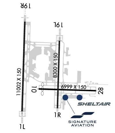
| Lat: N 2758.5 Long: W 08232.0 Elev: 26 Var: +05 Longest Runway: 11002 | ||
| Clr Del: 133.6 Dept. ATIS: 128.47 Arr. ATIS: 126.45 Ground: 121.35/121.7 Tower: 119.05/119.5 | ||
| |||||||||||||||||||||||||||||||||||||||||||||||||||||||||||||||||||||
| |||||||||||||||||||||||||||||||||||||||||||||||||||||||||||||||||||||
| |||||||||||||||||||||||||||||||||||||||||||||||||||||||||||||||||||||
| |||||||||||||||||||||||||||||||||||||||||||||||||||||||||||||||||||||
| |||||||||||||||||||||||||||||||||||||||||||||||||||||||||||||||||||||
| Rwy | Rwy | |||||||
| 11002x150 | 11002' | 108.90 - 006° | 11002x150 | 11002' | 108.50 - 186° | |||
| 8300x150 | 8300' | 111.95 - 006° | 8300x150 | 8300' | 110.30 - 186° | |||
| 6999x150 | 6501' | 6999x150 | 6999' | |||||
| Runway ID | Single Wheel | Double Wheel | Double Tandem Wheel | Dual Double Wheel |
| 01L/19R | 120,000 | 228,000 | 443,000 | 968,000 |
| 01R/19L | 120,000 | 208,000 | 392,000 | 896,000 |
| 10/28 | 120,000 | 250,000 | 550,000 | 1,113,000 |
| These numbers are Advisory and are not limits. The Airport Manager should have more accurate Weight Limits | ||||
 Airport Diagram might not be current. | |
| Facility Name: | TAMPA INTL |
| City Name: | TAMPA |
| County: | HILLSBOROUGH |
| State abbrev: | FL |
| State Name: | FLORIDA |
| Ownership: | PUBLICLY OWNED |
| Use: | OPEN TO THE PUBLIC |
| Owner's Name: | HILLSBOROUGH CO AVN AUTHORITY |
| Address: | PO BOX 22287 |
| TAMPA, FL 33622 | |
| Owner's Phone: | 813-870-8700 |
| Manager's Name: | JOHN TILIACOS |
| Address: | PO BOX 22287 |
| TAMPA, FL 33622 | |
| Phone: | 813-870-8700; 813-870-8752 |
| FAA Region: | SOUTHERN |
| FAA Field Office: | ORL |
| Date | Sunrise | Sunset |
|---|---|---|
| 04/14/25 Monday | 7:07 | 19:55 |
| 04/15/25 Tuesday | 7:06 | 19:55 |
| 04/16/25 Wednesday | 7:04 | 19:56 |
| 04/17/25 Thursday | 7:03 | 19:56 |
| 04/18/25 Friday | 7:02 | 19:57 |
| 04/19/25 Saturday | 7:01 | 19:58 |
| 04/20/25 Sunday | 7:00 | 19:58 |
| 04/21/25 Monday | 6:59 | 19:59 |
| 04/22/25 Tuesday | 6:59 | 19:59 |
| 04/23/25 Wednesday | 6:58 | 20:00 |
| 04/24/25 Thursday | 6:57 | 20:00 |
| 04/25/25 Friday | 6:56 | 20:01 |
| 04/26/25 Saturday | 6:55 | 20:02 |
| 04/27/25 Sunday | 6:54 | 20:02 |
| Airport Attendance Schedule | CONTINUOUS |
| Airport Status | OPERATIONAL (This Status can change at any time - please check NOTAMS) |
| Airport Lighting Schedule | SS-SR |
| Airport Storage Available | Tie Downs, Hanger |
| Extra Services Available | Avionics, Cargo Handling, Charter |
| Wind Indicator | YES - (lighted) |
| Control Tower | YES |
| CTAF Frequency | |
| Unicom Frequency | 122.950 |
| Rotating Beacon Color | WG |
| Segmented Circle | YES |
| Landing Fee | NO |
| Airport Inspected | FEDERAL - performed by FAA AIRPORTS FIELD PERSONNEL |
| Inspection Date | 05/24/2023 |
| Type of Fuel Available | Grade 100LL, JET A (freeze point -40C) |
| Airframe Repair Service | MAJOR |
| Power Plant Repair Service | MAJOR |
| Latitude | N2758.5 |
| Longitude | W08232.0 (ESTIMATED) |
| Arpt Elevation | 26ft (SURVEYED) |
| Magnetic Variation | 05W |
| 6 miles W | of TAMPA |
| Traffic Pattern Altitude | |
| Sectional Chart | MIAMI |
| Operations (Reported) | Yearly | Avg. Daily |
|---|---|---|
| General Aviation Transient | 0 | 0 |
| General Aviation Local | 0 | 0 |
| Air Taxi | 0 | 0 |
| Commerical | 0 | 0 |
| Commuter | 0 | 0 |
| Military | 0 | 0 |
| Aircraft based on Field | |
|---|---|
| General Aviation Singles | 0 |
| General Aviation Multi | 0 |
| Jet Aircraft | 0 |
| General Aviation Helicopters | 0 |
| Military Aircraft | 0 |
| Gliders | 0 |
| Ultralights | 0 |
| FSS on field | NO |
| FSS tie-in | SAINT PETERSBURG |
| FSS Phone | 1-800-WX-BRIEF |
| Who issues Notams | TPA |
| Notam D service at airport | YES |
| ARTCC Name | JACKSONVILLE |
| Airport Certification | AIRPORT RECEIVING SCHEDULED AIR CARRIER SERVICE FROM CARRIERS CERTIFICATED BY THE CIVIL AERONAUTICS BOARD |
| Aircraft Rescue & Firefighting Index | AIRPORT HAS A CERTIFICATE UNDER CFR PART 139 |
| Airport of Entry | YES |
| Custom Landing Rights | No |
| Joint Civil/Military | No |
| Military Landing rights | YES |
| NATIONAL PLAN OF INTEGRATED AIRPORT SYSTEMS (NPIAS) |
| GRANT AGREEMENTS UNDER FAAP/ADAP/AIP |
| SURPLUS PROPERTY AGREEMENT UNDER PUBLIC LAW 289 |
| SURPLUS PROPERTY AGREEMENT UNDER REGULATION 16-WAA |
| ASSURANCES PURSUANT TO TITLE VI, CIVIL RIGHTS ACT OF 1964 |
| RSTRS TO ADG IV OR LGR: TWY E1. |
| TXL K1 AND TXL K2 CLSD TO WINGSPANS GTR THAN 171 FT, TXL K1 AND TXL K2 CLSD WHILE WIDE BODY TXL K1W IS IN USE. |
| TWY J BTN TWY J1 AND TWY J2; TWY N W OF TWY L; TWY E N OF TWY J; TXL Z 325 FT E OF TXL V; TXL V BTN TWY V2 AND TWY V3 ARE UNAVBL FOR GROUP V ACFT WITH A WINGSPAN GTR THAN 171 FT WO PPR FROM ARPT OPS. |
| RWY 19L IS NOISE SENSITIVE TO TBJT DEPARTURES. RWY 01R IS NOISE SENSITIVE TO TBJT ARRIVALS. PUBLD NOISE ABATEMENT PROCS IN EFCT. |
| ONLY ACFT WITH PRIOR PMSN MAY USE TRML APN; ALL OTRS USE GA APN. |
| BIRD ACT ON AND INVOF ARPT. |
| TXL F AND TXL R ARE NON-MOVEMENT AREAS. BOTH LCTNS ARE UNAVBL FOR GROUP IV ACFT WITH A WINGSPAN GTR THAN 117 FT WO PPR FROM ARPT OPS. TXL T PPR FROM ARPT OPS RQRD FOR ACFT WITH A WINGSPAN GTR THAN 90 FT. |
| TAXILANE G WEST OF TWY B1 CLSD TO WINGSPAN GTR THAN 118 FT - PPR APT OPS. |
| RWY 10/2 8 NOT NMLY AVBL TO OPNS OVER 75,000 LBS GWT. |
| RWY 10/2 8 RWY 10 FIRST 2600 FT CONC; RWY 28 FIRST 4400 FT ASPH. |
| RWY 01L/ 19RPCR VALUE: 700/R/A/W/T |
| RWY 01R/ 19LPCR VALUE: 630/R/A/W/T |
| RWY 10/2 8 PCR VALUE: 870/R/A/W/T |
Airport Communications & Frequencies:
| |||||||||||||||||||||||||||||||||||||||||||||||||||||||||||||||||||||||
| Runway: 01L | Runway: 19R | ||
| Mag heading: | 7° | Mag heading: | 187° |
| Rwy Slope: | .09% Up | Rwy Slope: | -.09% Down |
| Approach: | ILS/DME | Approach: | ILS/DME |
| Pattern: | Left Traffic | Pattern: | Left Traffic |
| Markings: | PRECISION INSTRUMENT | Markings: | PRECISION INSTRUMENT |
| Marking Condition: | GOOD | Marking Condition: | GOOD |
| Arresting Dev: | Arresting Dev: | ||
| Lat & Long: | N2757.8 W08232.5 | Lat. & Long.: | N2759.6 W08232.5 |
| Elev: | 10.8 ft. MSL | Elev: | 21.0 ft. MSL |
| TCH: | 71 ft. AGL | TCH: | 71 ft. AGL |
| Visual Glide Path: | 3.00 degrees | Visual Glide Path: | 3.00 degrees |
| Displaced Threshold: | No | Displaced Threshold: | No |
| Touchdown Zone: | YES | Touchdown Zone: | YES |
| Touchdown Elev.: | 11.1 feet | Touchdown Elev.: | 21.1 feet |
| Visual Glide Slope: | 4-Light PAPI on LEFT side of Runway | Visual Glide Slope: | 4-Light PAPI on LEFT side of Runway |
| RVR Equipment: | TOUCHDOWN-MIDFIELD-ROLLOUT | RVR Equipment: | TOUCHDOWN-MIDFIELD-ROLLOUT |
| RVV Equipment: | NO | RVV Equipment: | NO |
| Approach Lights: | ALSF2 - standard 2,400 foot high intensity approach lighting system with sequenced flashers, Category II or III | Approach Lights: | MALSR - 1,400 foot medium intensity approach lighting system with runway alignment indicator lights |
| REIL: | NO | REIL: | NO |
| Centerline Lights: | YES | Centerline Lights: | YES |
| Touchdown lights: | YES | Touchdown lights: | NO |
| Runway Category: | Precision Instrument Runway | Runway Category: | Precision Instrument Runway |
| Declared Distances: | TORA:11002' TODA:11002' ASDA:10800' LDA:10800' | Declared Distances: | TORA:11002' TODA:11002' ASDA:11002' LDA:11002' |
| Obstructions: | Obstructions: | ROAD | |
| Marked: | Marked: | NOT Marked/Lighted | |
| Clearance slope: | 50:1 | Clearance slope: | 50:1 |
| Obstruction height: | Obstruction height: | 15 feet AGL | |
| Dist. from runway: | Dist. from runway: | 955 feet | |
| Centerline offset: | Centerline offset: | 500 feet right of centerline | |
| Comments: | Comments: |
| Runway: 01R | Runway: 19L | ||
| Mag heading: | 7° | Mag heading: | 187° |
| Rwy Slope: | .10% Up | Rwy Slope: | -.10% Down |
| Approach: | LOC/DME | Approach: | ILS/DME |
| Pattern: | Left Traffic | Pattern: | Left Traffic |
| Markings: | PRECISION INSTRUMENT | Markings: | PRECISION INSTRUMENT |
| Marking Condition: | GOOD | Marking Condition: | GOOD |
| Arresting Dev: | Arresting Dev: | ||
| Lat & Long: | N2757.9 W08231.7 | Lat. & Long.: | N2759.2 W08231.7 |
| Elev: | 17.6 ft. MSL | Elev: | 26.0 ft. MSL |
| TCH: | 71 ft. AGL | TCH: | 74 ft. AGL |
| Visual Glide Path: | 3.00 degrees | Visual Glide Path: | 3.00 degrees |
| Displaced Threshold: | No | Displaced Threshold: | No |
| Touchdown Zone: | YES | Touchdown Zone: | YES |
| Touchdown Elev.: | 20.5 feet | Touchdown Elev.: | 26.1 feet |
| Visual Glide Slope: | 4-Light PAPI on LEFT side of Runway | Visual Glide Slope: | 4-Light PAPI on LEFT side of Runway |
| RVR Equipment: | TOUCHDOWN-MIDFIELD-ROLLOUT | RVR Equipment: | TOUCHDOWN-MIDFIELD-ROLLOUT |
| RVV Equipment: | NO | RVV Equipment: | NO |
| Approach Lights: | Approach Lights: | ALSF2 - standard 2,400 foot high intensity approach lighting system with sequenced flashers, Category II or III | |
| REIL: | YES | REIL: | NO |
| Centerline Lights: | YES | Centerline Lights: | YES |
| Touchdown lights: | NO | Touchdown lights: | YES |
| Runway Category: | Runway with a Non-precision Approach having visibility minimums greater than 3/4 mile | Runway Category: | Precision Instrument Runway |
| Declared Distances: | TORA:8300' TODA:8300' ASDA:8300' LDA:8300' | Declared Distances: | TORA:8300' TODA:8300' ASDA:8300' LDA:8300' |
| Runway: 10 | Runway: 28 | ||
| Mag heading: | 97° | Mag heading: | 277° |
| Rwy Slope: | .17% Up | Rwy Slope: | -.17% Down |
| Approach: | Approach: | ||
| Pattern: | Left Traffic | Pattern: | Left Traffic |
| Markings: | NONPRECISION INSTRUMENT | Markings: | NONPRECISION INSTRUMENT |
| Marking Condition: | GOOD | Marking Condition: | GOOD |
| Arresting Dev: | Arresting Dev: | ||
| Lat & Long: | N2758.2 W08232.2 | Lat. & Long.: | N2758.2 W08230.9 |
| Elev: | 14.6 ft. MSL | Elev: | 26.5 ft. MSL |
| TCH: | 47 ft. AGL | TCH: | 50 ft. AGL |
| Visual Glide Path: | 3.00 degrees | Visual Glide Path: | 3.00 degrees |
| Displaced Threshold: | 498 feet | Displaced Threshold: | No |
| Touchdown Zone: | YES | Touchdown Zone: | YES |
| Touchdown Elev.: | 22.1 feet | Touchdown Elev.: | 26.5 feet |
| Visual Glide Slope: | 4-Light PAPI on LEFT side of Runway; RWY 10 PAPI UNUSBL 8 DEG LEFT AND RIGHT OF RCL. | Visual Glide Slope: | 4-Light PAPI on LEFT side of Runway |
| RVR Equipment: | RVR Equipment: | ||
| RVV Equipment: | NO | RVV Equipment: | NO |
| Approach Lights: | Approach Lights: | ||
| REIL: | NO | REIL: | NO |
| Centerline Lights: | NO | Centerline Lights: | NO |
| Touchdown lights: | NO | Touchdown lights: | NO |
| Runway Category: | Runway with a Non-precision Approach having visibility minimums greater than 3/4 mile | Runway Category: | Runway with a Non-precision Approach having visibility minimums greater than 3/4 mile |
| Declared Distances: | TORA:6999' TODA:6999' ASDA:6999' LDA:6501' | Declared Distances: | TORA:6999' TODA:6999' ASDA:6501' LDA:6501' |
| Obstructions: | RR | Obstructions: | TREES |
| Marked: | NOT Marked/Lighted | Marked: | NOT Marked/Lighted |
| Clearance slope: | 30:1; RWY 10 APCH SFC IS 50:1 TO MKD DSPLCD THR. | Clearance slope: | 35:1 |
| Obstruction height: | 18 feet AGL | Obstruction height: | 41 feet AGL |
| Dist. from runway: | 755 feet | Dist. from runway: | 1660 feet |
| Centerline offset: | 300 left of centerline | Centerline offset: | 190 feet left of centerline |
| Comments: | Comments: |
Thanks for using FltPlan.com
all rights reserved © 1999-2025 by Flight Plan LLC