
| LOGAN-CACHE LOGAN UT |
| |
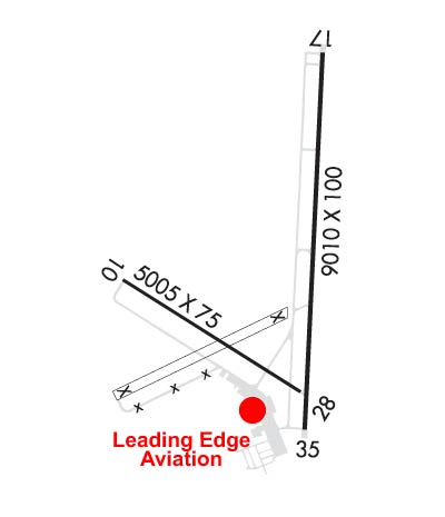
| Lat: N 4147.5 Long: W 11151.1 Elev: 4457 Var: -11 Longest Runway: 9020 | ||
| AWOS: 135.27 CTAF: 122.8 | ||
| ||||||||||||||||||||||||||||||||||||||||||||
| ||||||||||||||||||||||||||||||||||||||||||||
| ||||||||||||||||||||||||||||||||||||||||||||
| ||||||||||||||||||||||||||||||||||||||||||||
| Rwy | Rwy | |||||||
| 4075x60 | 4075' | 4075x60 | 4075' | |||||
| 9020x100 | 9020' | 109.15 - 171° | 9020x100 | 9020' | ||||
| Runway ID | Single Wheel | Double Wheel | Double Tandem Wheel | Dual Double Wheel |
| 10/28 | 12,000 | N/A | N/A | N/A |
| 17/35 | 24,000 | 179,000 | N/A | N/A |
| These numbers are Advisory and are not limits. The Airport Manager should have more accurate Weight Limits | ||||
 Airport Diagram might not be current. | |
| Facility Name: | LOGAN-CACHE |
| City Name: | LOGAN |
| County: | CACHE |
| State abbrev: | UT |
| State Name: | UTAH |
| Ownership: | PUBLICLY OWNED |
| Use: | OPEN TO THE PUBLIC |
| Owner's Name: | LOGAN CITY & CACHE CO |
| Address: | 199 N. MAIN |
| LOGAN, UT 84321 | |
| Owner's Phone: | (435) 755-1850 |
| Manager's Name: | BOB LOW |
| Address: | 199 N. MAIN |
| LOGAN, UT 84321 | |
| Phone: | 435-755-1750 |
| FAA Region: | NORTHWEST MOUNTAIN |
| FAA Field Office: | DEN |

| Date | Sunrise | Sunset |
|---|---|---|
| 01/14/25 Tuesday | 7:53 | 17:21 |
| 01/15/25 Wednesday | 7:53 | 17:22 |
| 01/16/25 Thursday | 7:52 | 17:23 |
| 01/17/25 Friday | 7:52 | 17:24 |
| 01/18/25 Saturday | 7:51 | 17:25 |
| 01/19/25 Sunday | 7:51 | 17:26 |
| 01/20/25 Monday | 7:50 | 17:28 |
| 01/21/25 Tuesday | 7:49 | 17:29 |
| 01/22/25 Wednesday | 7:49 | 17:30 |
| 01/23/25 Thursday | 7:48 | 17:31 |
| 01/24/25 Friday | 7:47 | 17:33 |
| 01/25/25 Saturday | 7:46 | 17:34 |
| 01/26/25 Sunday | 7:46 | 17:35 |
| 01/27/25 Monday | 7:45 | 17:36 |
| Airport Attendance Schedule | 7 Days A Week 0800-1900 |
| Airport Status | OPERATIONAL (This Status can change at any time - please check NOTAMS) |
| Airport Lighting Schedule | ACTVT MALSR RWY 17; REIL RWY 35; PAPI RWY 17 & 35; HIRL RWY 17/35 - CTAF. |
| Airport Storage Available | Tie Downs, Hanger |
| Extra Services Available | Charter, Flight Instruction, Aircraft Rental |
| Wind Indicator | YES - (lighted) |
| Control Tower | NO |
| CTAF Frequency | 122.800 |
| Unicom Frequency | 122.800 |
| Rotating Beacon Color | WG |
| Segmented Circle | YES |
| Landing Fee | NO |
| Airport Inspected | STATE - performed by FAA AIRPORTS FIELD PERSONNEL |
| Inspection Date | 06/26/2024 |
| Type of Fuel Available | Grade 100LL, JET A (freeze point -40C); -10AVBL H24 WITH CREDIT CARD; AFT HR - 435-753-2221/435-752-5955. |
| Airframe Repair Service | MAJOR |
| Power Plant Repair Service | MAJOR |
| Latitude | N4147.5 |
| Longitude | W11151.1 (ESTIMATED) |
| Arpt Elevation | 4456ft (ESTIMATED) |
| Magnetic Variation | 11E |
| 3 miles NW | of LOGAN |
| Traffic Pattern Altitude | |
| Sectional Chart | SALT LAKE CITY |
| Operations (Reported) | Yearly | Avg. Daily |
|---|---|---|
| General Aviation Transient | 0 | 0 |
| General Aviation Local | 0 | 0 |
| Air Taxi | 0 | 0 |
| Commerical | 0 | 0 |
| Commuter | 0 | 0 |
| Military | 0 | 0 |
| Aircraft based on Field | |
|---|---|
| General Aviation Singles | 0 |
| General Aviation Multi | 0 |
| Jet Aircraft | 0 |
| General Aviation Helicopters | 0 |
| Military Aircraft | 0 |
| Gliders | 0 |
| Ultralights | 0 |
| FSS on field | NO |
| FSS tie-in | CEDAR CITY |
| FSS Phone | 1-800-WX-BRIEF |
| Who issues Notams | LGU |
| Notam D service at airport | YES |
| ARTCC Name | SALT LAKE CITY |
| Airport Certification | |
| Aircraft Rescue & Firefighting Index | AIRPORT HAS A CERTIFICATE UNDER CFR PART 139 |
| Airport of Entry | No |
| Custom Landing Rights | No |
| Joint Civil/Military | No |
| Military Landing rights | YES |
| NATIONAL PLAN OF INTEGRATED AIRPORT SYSTEMS (NPIAS) |
| GRANT AGREEMENTS UNDER FAAP/ADAP/AIP |
| ASSURANCES PURSUANT TO TITLE VI, CIVIL RIGHTS ACT OF 1964 |
| AGREEMENT UNDER DLAND OR DCLA HAS EXPIRED. |
| BIRDS ON & INVOF ARPT SPRING & SUMMER. |
| COLD TEMPERATURE AIRPORT. ALTITUDE CORRECTION REQUIRED AT OR BELOW -15C. |
| FLT TRNG INVOF ARPT. |
| FOR CD CTC SALT LAKE ARTCC AT 801-320-2568. |
| RWY 10/2 8 DALGT USE ONLY. |
Airport Communications & Frequencies:
| |||||||||
| Runway: 10 | Runway: 28 | ||
| Mag heading: | 111° | Mag heading: | 291° |
| Rwy Slope: | .24% Up | Rwy Slope: | -.24% Down |
| Approach: | Approach: | ||
| Pattern: | Left Traffic | Pattern: | Left Traffic |
| Markings: | BASIC | Markings: | BASIC |
| Marking Condition: | POOR | Marking Condition: | POOR |
| Arresting Dev: | Arresting Dev: | ||
| Lat & Long: | N4147.5 W11151.9 | Lat. & Long.: | N4147.1 W11151.1 |
| Elev: | 4440.1 ft. MSL | Elev: | 4449.7 ft. MSL |
| TCH: | TCH: | ||
| Visual Glide Path: | Visual Glide Path: | ||
| Displaced Threshold: | No | Displaced Threshold: | No |
| Touchdown Zone: | YES | Touchdown Zone: | YES |
| Touchdown Elev.: | 4447.7 feet | Touchdown Elev.: | 4449.7 feet |
| Visual Glide Slope: | Visual Glide Slope: | ||
| RVR Equipment: | RVR Equipment: | ||
| RVV Equipment: | NO | RVV Equipment: | NO |
| Approach Lights: | Approach Lights: | ||
| REIL: | NO | REIL: | NO |
| Centerline Lights: | NO | Centerline Lights: | NO |
| Touchdown lights: | NO | Touchdown lights: | NO |
| Runway Category: | Runway with a Visual Approach | Runway Category: | Runway with a Visual Approach |
| Declared Distances: | TORA:4075' TODA:4075' | Declared Distances: | TORA:4075' TODA:4075' |
| Obstructions: | Obstructions: | RR | |
| Marked: | Marked: | NOT Marked/Lighted | |
| Clearance slope: | 50:1 | Clearance slope: | 12:1 |
| Obstruction height: | Obstruction height: | 23 feet AGL | |
| Dist. from runway: | Dist. from runway: | 485 feet | |
| Centerline offset: | Centerline offset: | B | |
| Comments: | Comments: |
| Runway: 17 | Runway: 35 | ||
| Mag heading: | 172° | Mag heading: | 352° |
| Rwy Slope: | .00% Down | Rwy Slope: | .00% Up |
| Approach: | ILS/DME | Approach: | |
| Pattern: | Left Traffic | Pattern: | Left Traffic |
| Markings: | PRECISION INSTRUMENT | Markings: | PRECISION INSTRUMENT |
| Marking Condition: | GOOD | Marking Condition: | GOOD |
| Arresting Dev: | Arresting Dev: | ||
| Lat & Long: | N4148.4 W11150.9 | Lat. & Long.: | N4146.9 W11151.0 |
| Elev: | 4456.8 ft. MSL | Elev: | 4456.4 ft. MSL |
| TCH: | 45 ft. AGL | TCH: | 39 ft. AGL |
| Visual Glide Path: | 3.00 degrees | Visual Glide Path: | 3.00 degrees |
| Displaced Threshold: | No | Displaced Threshold: | No |
| Touchdown Zone: | YES | Touchdown Zone: | YES |
| Touchdown Elev.: | 4456.9 feet | Touchdown Elev.: | 4456.4 feet |
| Visual Glide Slope: | 2-Light PAPI on LEFT side of Runway | Visual Glide Slope: | 2-Light PAPI on LEFT side of Runway |
| RVR Equipment: | RVR Equipment: | ||
| RVV Equipment: | NO | RVV Equipment: | NO |
| Approach Lights: | MALSR - 1,400 foot medium intensity approach lighting system with runway alignment indicator lights | Approach Lights: | |
| REIL: | NO | REIL: | YES |
| Centerline Lights: | NO | Centerline Lights: | NO |
| Touchdown lights: | NO | Touchdown lights: | NO |
| Runway Category: | Precision Instrument Runway | Runway Category: | Runway with a Non-precision Approach having visibility minimums greater than 3/4 mile |
| Declared Distances: | TORA:9020' TODA:9020' ASDA:9020' LDA:9020' | Declared Distances: | TORA:9020' TODA:9020' ASDA:9020' LDA:9020' |
| Obstructions: | RR | Obstructions: | |
| Marked: | NOT Marked/Lighted | Marked: | |
| Clearance slope: | 15:1 | Clearance slope: | 50:1 |
| Obstruction height: | 23 feet AGL | Obstruction height: | |
| Dist. from runway: | 555 feet | Dist. from runway: | |
| Centerline offset: | 560 left of centerline | Centerline offset: | |
| Comments: | Comments: |
Thanks for using FltPlan.com
all rights reserved © 1999-2025 by Flight Plan LLC