| WRIGHT AAF (FORT STEWART) HINESVILLE GA |
| |
| Lat: N 3153.3 Long: W 08133.8 Elev: 47 Var: +04 Longest Runway: 6500 | ||
| Dept. ATIS: 118.47 Arr. ATIS: 118.47 Ground: 121.7 Tower: 126.25 | ||
| ||||||||||||||||||||||||||||||||||||||||||||||||||||||||||||||||||||
| ||||||||||||||||||||||||||||||||||||||||||||||||||||||||||||||||||||
| ||||||||||||||||||||||||||||||||||||||||||||||||||||||||||||||||||||
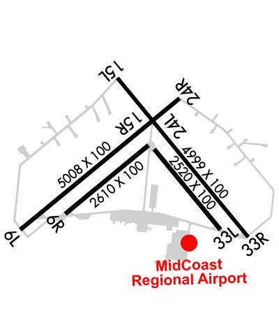
| Rwy | Rwy | |||||||
| 6500x100 | 6500' | 6500x100 | 6500' | |||||
| 2610x100 | 2610' | 2610x100 | 2610' | |||||
| 5001x100 | 5001' | 5001x100 | 5001' | |||||
| 2520x100 | 2520' | 2520x100 | 2520' | |||||
| Runway ID | Single Wheel | Double Wheel | Double Tandem Wheel | Dual Double Wheel |
| 06L/24R | N/A | N/A | N/A | N/A |
| 06R/24L | N/A | N/A | N/A | N/A |
| 15L/33R | N/A | N/A | N/A | N/A |
| 15R/33L | N/A | N/A | N/A | N/A |
| H1 | N/A | N/A | N/A | N/A |
| These numbers are Advisory and are not limits. The Airport Manager should have more accurate Weight Limits | ||||
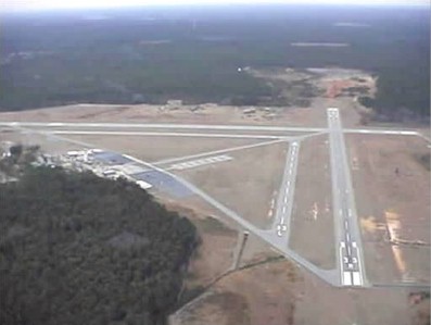
 Airport Diagram might not be current. | |
| Facility Name: | WRIGHT AAF (FORT STEWART)/MIDCOAST RGNL |
| City Name: | FORT STEWART (HINESVILLE) |
| County: | LIBERTY |
| State abbrev: | GA |
| State Name: | GEORGIA |
| Ownership: | ARMY OWNED |
| Use: | OPEN TO THE PUBLIC |
| Owner's Name: | US ARMY AERONAUTICAL SVCS AGENCY |
| Address: | |
| FT BELVOIR, VA 22060 | |
| Owner's Phone: | |
| Manager's Name: | JESSE WILLETT |
| Address: | 1116 E. LOWE CIRCLE |
| HINESVILLE, GA 31315 | |
| Phone: | (912) 435-3130 |
| FAA Region: | SOUTHERN |
| FAA Field Office: | ATL |
| Date | Sunrise | Sunset |
|---|---|---|
| 10/23/24 Wednesday | 7:36 | 18:44 |
| 10/24/24 Thursday | 7:37 | 18:43 |
| 10/25/24 Friday | 7:38 | 18:42 |
| 10/26/24 Saturday | 7:39 | 18:41 |
| 10/27/24 Sunday | 7:39 | 18:40 |
| 10/28/24 Monday | 7:40 | 18:39 |
| 10/29/24 Tuesday | 7:41 | 18:39 |
| 10/30/24 Wednesday | 7:42 | 18:38 |
| 10/31/24 Thursday | 7:43 | 18:37 |
| 11/01/24 Friday | 7:43 | 18:36 |
| 11/02/24 Saturday | 7:44 | 18:35 |
| 11/03/24 Sunday | 6:45 | 17:34 |
| 11/04/24 Monday | 6:46 | 17:33 |
| 11/05/24 Tuesday | 6:47 | 17:33 |
| Airport Attendance Schedule | MON-FRI 0600-2300; TWR WILL OPEN FOR JOSAC MISSIONS, DSN 435-3103. WHEN BASE OPS CLSD, CTC HUNTER BASE OPS DSN 729-5110, SEE FLIP AP/1 FLT HAZ AND SUPPLEMENTARY ARPT |
| Airport Status | OPERATIONAL (This Status can change at any time - please check NOTAMS) |
| Airport Lighting Schedule | WHEN ATCT & MARNE RDO BOTH CLSD, ACTVT PAPI RWY 06L & 33R; HIRL RWY 06L/24R & 15L/33R; TWY A, B, C, & F - CTAF. |
| Airport Storage Available | Tie Downs |
| Extra Services Available | NONE |
| Wind Indicator | YES - (lighted) |
| Control Tower | YES |
| CTAF Frequency | 126.250 |
| Unicom Frequency | |
| Rotating Beacon Color | SWG |
| Segmented Circle | YES |
| Landing Fee |
| Airport Inspected | No Inspection Data Available performed by STATE AERONAUTICAL PERSONNEL |
| Inspection Date | 05/12/2023 |
| Type of Fuel Available | Grade 100LL, JET A |
| Airframe Repair Service | NONE |
| Power Plant Repair Service | NONE |
| Latitude | N3153.3 |
| Longitude | W08133.8 (ESTIMATED) |
| Arpt Elevation | 46ft (SURVEYED) |
| Magnetic Variation | 04W |
| 0 miles | of FORT STEWART (HINESVILLE) |
| Traffic Pattern Altitude | |
| Sectional Chart | JACKSONVILLE |
| Operations (Reported) | Yearly | Avg. Daily |
|---|---|---|
| General Aviation Transient | 0 | 0 |
| General Aviation Local | 0 | 0 |
| Air Taxi | 0 | 0 |
| Commerical | 0 | 0 |
| Commuter | 0 | 0 |
| Military | 0 | 0 |
| Aircraft based on Field | |
|---|---|
| General Aviation Singles | 0 |
| General Aviation Multi | 0 |
| Jet Aircraft | 0 |
| General Aviation Helicopters | 0 |
| Military Aircraft | 0 |
| Gliders | 0 |
| Ultralights | 0 |
| FSS on field | NO |
| FSS tie-in | MACON |
| FSS Phone | 1-800-WX-BRIEF |
| Who issues Notams | LHW |
| Notam D service at airport | YES |
| ARTCC Name | JACKSONVILLE |
| Airport Certification | |
| Aircraft Rescue & Firefighting Index | None |
| Airport of Entry | No |
| Custom Landing Rights | No |
| Joint Civil/Military | YES |
| Military Landing rights | No |
| NATIONAL PLAN OF INTEGRATED AIRPORT SYSTEMS (NPIAS) |
| FUEL: J8 AVBL FBO, C912-877-4359 (NC 100LL) 1300-0600Z++ MON-FRI, EXC HOL, OT 24 HR PPR. TRAN FUEL PPR, CTC BASE OPS 571-801-1579/1580. |
| CAUTION: EXTV R/W TRNG MIN LGT SS-SR. CTC TWR PRIOR TO ENTERING CLASS D AIRSPACE. R3005 1.4 NM NW OF AFLD. DEER AND PIG HAZ. |
| MISC: MOORING/TIE-DOWN STRAPS NOT AVBL. |
| RSTD: AVIATORS BRIEFED IN THE LAST 6 MOS MAY RECEIVE A TELEPHONIC UPDATE BRIEFING. CTC HUNTER AAF OPS C571-801-8263/64. 1200-0100Z++ MON-FRI. |
| CIVILIAN FBO PH#'S 912-877-4364 & 912877-4359. |
| UNMANNED ACFT ACT IN CLASS D. |
| RSTD: TWY E NON MOVEMENT AREAS CLSD TO FIXED WING, ROTARY WING USE WITH PRIOR APPROVAL. |
| MISC: FULL WX SVC EFF 1100-0400Z++MON-FRI, CLSD WEEKEND AND FEDERAL HOL, OT REMOTE BRIEFING FR 26 OWS BARKSDALE AFB, LA, DSN 331-2651/2/3, C318-529-2651/2/3. DUR PERIODS OF AUGMENT ATC WILL ASSIST IN COOPERATIVE WX WATCH BY NOTIFYING WX OF UNREPORTED COND. AUGMENTATION MODE, PREVAIL SFC VIS MAY NOT BE REPRESENTED OF ENTIRE AFLD DUE TO BLDG OBST AND LACK OF VIS. MARK BYD 1 1/2 SM. KLHW FCST 571-801-1585/86. |
| MISC: OPR HRS MAY VARY WITH LCL FLYING SHED. |
| COMM: CTAF MARNE RDO - OPR 1230Z++ MON-0400Z++ SAT, SUN 1230Z++ - 0400Z++ EXC HOL. MIDCOAST REGIONAL-FBO OPR 1200-0000Z++. 123.075. |
| MISC: MAIN RAMP PARKING PADS 15-18 PERM CLSD / SOUTHERN TAXI LANE PERM CLSD. |
| CAUTION: TWYS A, B, C SIGNS REMOVED OR U/S. TWY E PERM CLSD. |
| R/W ACFT PILOTS PLANNING TO CONDUCT OPR WITHIN R3005 MUST RCV A RNG BRIEFING PRIOR TO ANY OPR. BRIEFING SHALL BE ACCOMPLISHED AT LEAST 4 HRS PRIOR TO FLT ON THE RESERVATION. |
| CAUITON: RWY 33R/15L SIGNS REMOVED OR U/S. RWY 24R SIGNS REMOVED OR UNSERVICEABLE. |
| CAUTION: ALL DISTANCE REMAINING SIGNS MISSING FROM ALL RWYS. |
| MISC: NO OVERRUNS FOR RWY 24R, 15L/33R. |
| RSTD: ALL MIL PPR AND MIL TRAN ACFT, CTC BASE OPS 571-801-1579/1580. |
| NS ABTMT: NO OVFT OF CANTONMENT AREA OR CITY OF HINESVILLE BELOW 1000 FT AGL. |
| RWY 06R/ 24LRWY 6R/24L CLSD INDEFLY. |
| RWY 15R/ 33LRWY 15R/33L CLSD INDEFLY. |
Airport Communications & Frequencies:
| |||||||||||||||||||||||||||||
| Runway: 06L | Runway: 24R | ||
| Mag heading: | 55° | Mag heading: | 235° |
| Rwy Slope: | -.19% Down | Rwy Slope: | .19% Up |
| Approach: | Approach: | ||
| Pattern: | Right Traffic; RIGHT TFC RWY 06L CATS B C D & E. | Pattern: | Left Traffic |
| Markings: | NONPRECISION INSTRUMENT | Markings: | NONPRECISION INSTRUMENT |
| Marking Condition: | FAIR | Marking Condition: | FAIR |
| Arresting Dev: | Arresting Dev: | ||
| Lat & Long: | N3152.9 W08134.5 | Lat. & Long.: | N3153.6 W08133.5 |
| Elev: | 45.7 ft. MSL | Elev: | 33.5 ft. MSL |
| TCH: | 48 ft. AGL | TCH: | |
| Visual Glide Path: | 3.00 degrees | Visual Glide Path: | |
| Displaced Threshold: | No | Displaced Threshold: | No |
| Touchdown Zone: | YES | Touchdown Zone: | YES |
| Touchdown Elev.: | 45.7 feet | Touchdown Elev.: | 46.6 feet |
| Visual Glide Slope: | 4-Light PAPI on LEFT side of Runway | Visual Glide Slope: | |
| RVR Equipment: | RVR Equipment: | ||
| RVV Equipment: | NO | RVV Equipment: | NO |
| Approach Lights: | Approach Lights: | ||
| REIL: | NO | REIL: | NO |
| Centerline Lights: | NO | Centerline Lights: | NO |
| Touchdown lights: | NO | Touchdown lights: | NO |
| Runway Category: | Runway with a Non-precision Approach having visibility minimums greater than 3/4 mile | Runway Category: | Runway with a Visual Approach |
| Declared Distances: | Declared Distances: |
| Runway: 06R | Runway: 24L | ||
| Mag heading: | 55° | Mag heading: | 235° |
| Rwy Slope: | -.08% Down | Rwy Slope: | .08% Up |
| Approach: | Approach: | ||
| Pattern: | Left Traffic | Pattern: | Left Traffic |
| Markings: | BASIC | Markings: | BASIC |
| Marking Condition: | POOR; RWY 6R/24L MARKINGS BADLY FADED. | Marking Condition: | POOR |
| Arresting Dev: | Arresting Dev: | ||
| Lat & Long: | N3153.1 W08134.1 | Lat. & Long.: | N3153.4 W08133.7 |
| Elev: | 41.1 ft. MSL | Elev: | 39.0 ft. MSL |
| TCH: | TCH: | ||
| Visual Glide Path: | Visual Glide Path: | ||
| Displaced Threshold: | No | Displaced Threshold: | No |
| Touchdown Zone: | YES | Touchdown Zone: | YES |
| Touchdown Elev.: | 46.1 feet | Touchdown Elev.: | 46.1 feet |
| Visual Glide Slope: | Visual Glide Slope: | ||
| RVR Equipment: | RVR Equipment: | ||
| RVV Equipment: | NO | RVV Equipment: | NO |
| Approach Lights: | Approach Lights: | ||
| REIL: | NO | REIL: | NO |
| Centerline Lights: | NO | Centerline Lights: | NO |
| Touchdown lights: | NO | Touchdown lights: | NO |
| Runway Category: | Runway with a Visual Approach | Runway Category: | Runway with a Visual Approach |
| Declared Distances: | Declared Distances: |
| Runway: 15L | Runway: 33R | ||
| Mag heading: | 145° | Mag heading: | 325° |
| Rwy Slope: | -.08% Down | Rwy Slope: | .08% Up |
| Approach: | Approach: | ||
| Pattern: | Left Traffic | Pattern: | Left Traffic |
| Markings: | NONPRECISION INSTRUMENT | Markings: | NONPRECISION INSTRUMENT |
| Marking Condition: | FAIR | Marking Condition: | FAIR |
| Arresting Dev: | Arresting Dev: | ||
| Lat & Long: | N3153.7 W08133.8 | Lat. & Long.: | N3153.0 W08133.2 |
| Elev: | 37.3 ft. MSL | Elev: | 33.2 ft. MSL |
| TCH: | TCH: | 65 ft. AGL | |
| Visual Glide Path: | Visual Glide Path: | 3.00 degrees | |
| Displaced Threshold: | No | Displaced Threshold: | No |
| Touchdown Zone: | YES | Touchdown Zone: | YES |
| Touchdown Elev.: | 40.6 feet | Touchdown Elev.: | 40.6 feet |
| Visual Glide Slope: | Visual Glide Slope: | 4-Light PAPI on LEFT side of Runway | |
| RVR Equipment: | RVR Equipment: | ||
| RVV Equipment: | NO | RVV Equipment: | NO |
| Approach Lights: | Approach Lights: | ||
| REIL: | NO | REIL: | NO |
| Centerline Lights: | NO | Centerline Lights: | NO |
| Touchdown lights: | NO | Touchdown lights: | NO |
| Runway Category: | Runway with a Visual Approach | Runway Category: | Runway with a Non-precision Approach having visibility minimums greater than 3/4 mile |
| Declared Distances: | Declared Distances: |
| Runway: 15R | Runway: 33L | ||
| Mag heading: | 145° | Mag heading: | 325° |
| Rwy Slope: | -.27% Down | Rwy Slope: | .27% Up |
| Approach: | Approach: | ||
| Pattern: | Left Traffic | Pattern: | Left Traffic |
| Markings: | BASIC | Markings: | BASIC |
| Marking Condition: | POOR; RWY 15R/33L MARKINGS BADLY FADED. | Marking Condition: | POOR |
| Arresting Dev: | Arresting Dev: | ||
| Lat & Long: | N3153.4 W08133.6 | Lat. & Long.: | N3153.1 W08133.3 |
| Elev: | 38.3 ft. MSL | Elev: | 31.6 ft. MSL |
| TCH: | TCH: | ||
| Visual Glide Path: | Visual Glide Path: | ||
| Displaced Threshold: | No | Displaced Threshold: | No |
| Touchdown Zone: | YES | Touchdown Zone: | YES |
| Touchdown Elev.: | 41.9 feet | Touchdown Elev.: | 41.9 feet |
| Visual Glide Slope: | Visual Glide Slope: | ||
| RVR Equipment: | RVR Equipment: | ||
| RVV Equipment: | NO | RVV Equipment: | NO |
| Approach Lights: | Approach Lights: | ||
| REIL: | NO | REIL: | NO |
| Centerline Lights: | NO | Centerline Lights: | NO |
| Touchdown lights: | NO | Touchdown lights: | NO |
| Runway Category: | Runway with a Visual Approach | Runway Category: | Runway with a Visual Approach |
| Declared Distances: | Declared Distances: |
Thanks for using FltPlan.com
all rights reserved © 1999-2024 by Flight Plan LLC