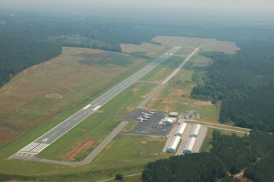
| LANCASTER COUNTY-MC WHIRTER LANCASTER SC |
| |
| Lat: N 3443.4 Long: W 08051.3 Elev: 486 Var: +07 Longest Runway: 6004 | ||
| AWOS: 120.82 CTAF: 122.72 | ||
| ||||||||||||||||||||||||||||||||||||||||||||
| ||||||||||||||||||||||||||||||||||||||||||||
| ||||||||||||||||||||||||||||||||||||||||||||
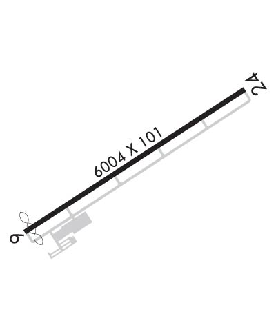
| Rwy | Rwy | |||||||
| 6004x101 | 5899' | 6004x101 | 6004' | |||||
| Runway ID | Single Wheel | Double Wheel | Double Tandem Wheel | Dual Double Wheel |
| 06/24 | 44,000 | 60,000 | 118,000 | N/A |
| These numbers are Advisory and are not limits. The Airport Manager should have more accurate Weight Limits | ||||
 Airport Diagram might not be current. | |
| Facility Name: | LANCASTER COUNTY-MC WHIRTER FLD |
| City Name: | LANCASTER |
| County: | LANCASTER |
| State abbrev: | SC |
| State Name: | SOUTH CAROLINA |
| Ownership: | PUBLICLY OWNED |
| Use: | OPEN TO THE PUBLIC |
| Owner's Name: | LANCASTER COUNTY |
| Address: | P.O.BOX 1809 |
| LANCASTER, SC 29721 | |
| Owner's Phone: | 803-285-1565 |
| Manager's Name: | PAUL MOSES |
| Address: | 286 AVIATION BLVD, LANCASTER |
| LANCASTER, SC 29720 | |
| Phone: | (803) 285-1513 |
| FAA Region: | SOUTHERN |
| FAA Field Office: | ATL |
| Date | Sunrise | Sunset |
|---|---|---|
| 01/31/25 Friday | 7:23 | 17:52 |
| 02/01/25 Saturday | 7:22 | 17:53 |
| 02/02/25 Sunday | 7:21 | 17:54 |
| 02/03/25 Monday | 7:20 | 17:55 |
| 02/04/25 Tuesday | 7:20 | 17:56 |
| 02/05/25 Wednesday | 7:19 | 17:57 |
| 02/06/25 Thursday | 7:18 | 17:58 |
| 02/07/25 Friday | 7:17 | 17:59 |
| 02/08/25 Saturday | 7:16 | 18:00 |
| 02/09/25 Sunday | 7:15 | 18:01 |
| 02/10/25 Monday | 7:14 | 18:02 |
| 02/11/25 Tuesday | 7:13 | 18:03 |
| 02/12/25 Wednesday | 7:12 | 18:04 |
| 02/13/25 Thursday | 7:11 | 18:04 |
| Airport Attendance Schedule | 7 Days A Week 0730-1500 |
| Airport Status | OPERATIONAL (This Status can change at any time - please check NOTAMS) |
| Airport Lighting Schedule | ACTVT REIL RWY 06 & 24; MIRL RWY 06/24 - CTAF. PAPI RWY 06 & 24 OPR CONSLY. |
| Airport Storage Available | Tie Downs, Hanger |
| Extra Services Available | Flight Instruction |
| Wind Indicator | YES - (lighted) |
| Control Tower | NO |
| CTAF Frequency | 122.725 |
| Unicom Frequency | 122.725 |
| Rotating Beacon Color | WG |
| Segmented Circle | YES |
| Landing Fee | YES |
| Airport Inspected | STATE - performed by STATE AERONAUTICAL PERSONNEL |
| Inspection Date | 04/02/2024 |
| Type of Fuel Available | Grade 100LL, JET A (freeze point -40C); -10FOR FUEL AFT HRS CALL 803-285-1513 |
| Airframe Repair Service | NONE |
| Power Plant Repair Service | NONE |
| Latitude | N3443.4 |
| Longitude | W08051.3 (ESTIMATED) |
| Arpt Elevation | 485ft (SURVEYED) |
| Magnetic Variation | 07W |
| 4 miles W | of LANCASTER |
| Traffic Pattern Altitude | |
| Sectional Chart | CHARLOTTE |
| Operations (Reported) | Yearly | Avg. Daily |
|---|---|---|
| General Aviation Transient | 0 | 0 |
| General Aviation Local | 0 | 0 |
| Air Taxi | 0 | 0 |
| Commerical | 0 | 0 |
| Commuter | 0 | 0 |
| Military | 0 | 0 |
| Aircraft based on Field | |
|---|---|
| General Aviation Singles | 0 |
| General Aviation Multi | 0 |
| Jet Aircraft | 0 |
| General Aviation Helicopters | 0 |
| Military Aircraft | 0 |
| Gliders | 0 |
| Ultralights | 0 |
| FSS on field | NO |
| FSS tie-in | ANDERSON |
| FSS Phone | 1-800-WX-BRIEF |
| Who issues Notams | AND |
| Notam D service at airport | YES |
| ARTCC Name | ATLANTA |
| Airport Certification | |
| Aircraft Rescue & Firefighting Index | None |
| Airport of Entry | No |
| Custom Landing Rights | No |
| Joint Civil/Military | No |
| Military Landing rights | YES |
| NATIONAL PLAN OF INTEGRATED AIRPORT SYSTEMS (NPIAS) |
| GRANT AGREEMENTS UNDER FAAP/ADAP/AIP |
| ASSURANCES PURSUANT TO TITLE VI, CIVIL RIGHTS ACT OF 1964 |
| 25 FT DROP; 250 FT FM THR RWY 06. |
| DEER ON & INVOF ARPT. |
| GCO AVBL ON FREQ 121.725 TO CHARLOTTE APCH. |
| SMALL ACFT MUST BE ON A TIE DOWN. |
| FOR CD CTC CHARLOTTE APCH AT 704-359-0241. |
| ARL APPLICATORS NOT PMTD DUE TO PAVEMENT CONDS. |
Airport Communications & Frequencies:
| ||||||||||||||
| Runway: 06 | Runway: 24 | ||
| Mag heading: | 66° | Mag heading: | 246° |
| Rwy Slope: | .44% Up | Rwy Slope: | -.44% Down |
| Approach: | Approach: | ||
| Pattern: | Left Traffic | Pattern: | Left Traffic |
| Markings: | NONPRECISION INSTRUMENT | Markings: | NONPRECISION INSTRUMENT |
| Marking Condition: | GOOD | Marking Condition: | GOOD |
| Arresting Dev: | Arresting Dev: | ||
| Lat & Long: | N3443.1 W08051.8 | Lat. & Long.: | N3443.6 W08050.8 |
| Elev: | 459.3 ft. MSL | Elev: | 485.7 ft. MSL |
| TCH: | 41 ft. AGL | TCH: | 39 ft. AGL |
| Visual Glide Path: | 3.00 degrees | Visual Glide Path: | 3.15 degrees |
| Displaced Threshold: | 105 feet | Displaced Threshold: | No |
| Touchdown Zone: | YES | Touchdown Zone: | YES |
| Touchdown Elev.: | 470.3 feet | Touchdown Elev.: | 485.9 feet |
| Visual Glide Slope: | 2-Light PAPI on LEFT side of Runway | Visual Glide Slope: | 2-Light PAPI on LEFT side of Runway |
| RVR Equipment: | RVR Equipment: | ||
| RVV Equipment: | NO | RVV Equipment: | NO |
| Approach Lights: | Approach Lights: | ||
| REIL: | YES | REIL: | YES |
| Centerline Lights: | NO | Centerline Lights: | NO |
| Touchdown lights: | NO | Touchdown lights: | NO |
| Runway Category: | D | Runway Category: | Runway with a Non-precision Approach having visibility minimums greater than 3/4 mile |
| Declared Distances: | Declared Distances: | ||
| Obstructions: | TREE | Obstructions: | TREE |
| Marked: | NOT Marked/Lighted | Marked: | NOT Marked/Lighted |
| Clearance slope: | 19:1 | Clearance slope: | 28:1 |
| Obstruction height: | 17 feet AGL | Obstruction height: | 150 feet AGL |
| Dist. from runway: | 524 feet | Dist. from runway: | 4473 feet |
| Centerline offset: | 101 left of centerline | Centerline offset: | 473 feet left of centerline |
| Comments: | Comments: |
Thanks for using FltPlan.com
all rights reserved © 1999-2025 by Flight Plan LLC