
| UNION COUNTY MARYSVILLE OH |
| |
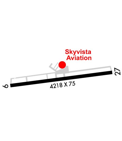
| Lat: N 4013.5 Long: W 08321.1 Elev: 1021 Var: +05 Longest Runway: 4218 | ||
| AWOS: 119.27 CTAF: 122.8 | ||
| |||||||||||||||||||||||||||||||||||||||||||||||||||||||||||||
| |||||||||||||||||||||||||||||||||||||||||||||||||||||||||||||
| |||||||||||||||||||||||||||||||||||||||||||||||||||||||||||||
| Rwy | Rwy | |||||||
| 2702x81 | 2702' | 2702x81 | 2702' | |||||
| 4218x75 | 4218' | 4218x75 | 4095' | |||||
| Runway ID | Single Wheel | Double Wheel | Double Tandem Wheel | Dual Double Wheel |
| 08/26 | N/A | N/A | N/A | N/A |
| 09/27 | 17,000 | N/A | N/A | N/A |
| These numbers are Advisory and are not limits. The Airport Manager should have more accurate Weight Limits | ||||
 Airport Diagram might not be current. | |
| Facility Name: | UNION COUNTY |
| City Name: | MARYSVILLE |
| County: | UNION |
| State abbrev: | OH |
| State Name: | OHIO |
| Ownership: | PUBLICLY OWNED |
| Use: | OPEN TO THE PUBLIC |
| Owner's Name: | UNION COUNTY ARPT AUTH |
| Address: | COUNTY COURTHOUSE, 215 W 5TH ST |
| MARYSVILLE, OH 43040 | |
| Owner's Phone: | 937-644-2055 |
| Manager's Name: | DAVID HOLDEN; SKYVISTAAVIATION@GMAIL.COM. |
| Address: | 760 CLYMER RD |
| MARYSVILLE, OH 43040-9502 | |
| Phone: | 937-644-2055; AFT HRS & EMERG 937-741-3120. |
| FAA Region: | GREAT LAKES |
| FAA Field Office: | DET |

| Date | Sunrise | Sunset |
|---|---|---|
| 02/07/25 Friday | 7:37 | 17:59 |
| 02/08/25 Saturday | 7:35 | 18:00 |
| 02/09/25 Sunday | 7:34 | 18:02 |
| 02/10/25 Monday | 7:33 | 18:03 |
| 02/11/25 Tuesday | 7:32 | 18:04 |
| 02/12/25 Wednesday | 7:31 | 18:05 |
| 02/13/25 Thursday | 7:30 | 18:06 |
| 02/14/25 Friday | 7:28 | 18:08 |
| 02/15/25 Saturday | 7:27 | 18:09 |
| 02/16/25 Sunday | 7:26 | 18:10 |
| 02/17/25 Monday | 7:24 | 18:11 |
| 02/18/25 Tuesday | 7:23 | 18:12 |
| 02/19/25 Wednesday | 7:22 | 18:14 |
| 02/20/25 Thursday | 7:20 | 18:15 |
| Airport Attendance Schedule | 7 Days A Week 0800-1700 |
| Airport Status | OPERATIONAL (This Status can change at any time - please check NOTAMS) |
| Airport Lighting Schedule | ACTVT REIL RWY 09 & 27; PAPI RWY 09 & 27; MIRL RWY 09/27 - CTAF. |
| Airport Storage Available | Tie Downs, Hanger |
| Extra Services Available | Flight Instruction, Aircraft Rental |
| Wind Indicator | YES - (lighted) |
| Control Tower | NO |
| CTAF Frequency | 122.800 |
| Unicom Frequency | 122.800 |
| Rotating Beacon Color | WG |
| Segmented Circle | NO |
| Landing Fee | NO; RAMP FEE FOR COML ACFT. |
| Airport Inspected | STATE - performed by STATE AERONAUTICAL PERSONNEL |
| Inspection Date | 06/05/2023 |
| Type of Fuel Available | Grade 100LL, JET A-1 (freeze point -50C), JET A-1 (icing inhibitor, freeze point -50C); -10FUEL AVBL H24 SELF SVC VIA CREDIT CARD. |
| Airframe Repair Service | MAJOR |
| Power Plant Repair Service | MAJOR |
| Latitude | N4013.5 |
| Longitude | W08321.1 (ESTIMATED) |
| Arpt Elevation | 1020ft (SURVEYED) |
| Magnetic Variation | 05W |
| 1 miles SE | of MARYSVILLE |
| Traffic Pattern Altitude | |
| Sectional Chart | DETROIT |
| Operations (Reported) | Yearly | Avg. Daily |
|---|---|---|
| General Aviation Transient | 0 | 0 |
| General Aviation Local | 0 | 0 |
| Air Taxi | 0 | 0 |
| Commerical | 0 | 0 |
| Commuter | 0 | 0 |
| Military | 0 | 0 |
| Aircraft based on Field | |
|---|---|
| General Aviation Singles | 0 |
| General Aviation Multi | 0 |
| Jet Aircraft | 0 |
| General Aviation Helicopters | 0 |
| Military Aircraft | 0 |
| Gliders | 0 |
| Ultralights | 0 |
| FSS on field | NO |
| FSS tie-in | DAYTON |
| FSS Phone | 1-800-WX-BRIEF |
| Who issues Notams | DAY |
| Notam D service at airport | YES |
| ARTCC Name | INDIANAPOLIS |
| Airport Certification | |
| Aircraft Rescue & Firefighting Index | None |
| Airport of Entry | No |
| Custom Landing Rights | No |
| Joint Civil/Military | No |
| Military Landing rights | YES |
| NATIONAL PLAN OF INTEGRATED AIRPORT SYSTEMS (NPIAS) |
| GRANT AGREEMENTS UNDER FAAP/ADAP/AIP |
| ASSURANCES PURSUANT TO TITLE VI, CIVIL RIGHTS ACT OF 1964 |
| DEER, BIRDS, & OTR WILDLIFE ON & INVOF ARPT. |
| FOR CD CTC COLUMBUS APCH AT 614-338-8537. |
| RWY 09 CALM WIND RWY. |
Airport Communications & Frequencies:
| ||||||||||||||
| Runway: 08 | Runway: 26 | ||
| Mag heading: | 88° | Mag heading: | 268° |
| Rwy Slope: | -.79% Down | Rwy Slope: | .79% Up |
| Approach: | Approach: | ||
| Pattern: | Left Traffic | Pattern: | Left Traffic |
| Markings: | Markings: | ||
| Marking Condition: | THR & EDGES MKD WITH CONES. | Marking Condition: | THR & EDGES MKD WITH CONES. |
| Arresting Dev: | Arresting Dev: | ||
| Lat & Long: | N4013.4 W08321.4 | Lat. & Long.: | N4013.5 W08320.8 |
| Elev: | 1015.2 ft. MSL | Elev: | 993.9 ft. MSL |
| TCH: | TCH: | ||
| Visual Glide Path: | Visual Glide Path: | ||
| Displaced Threshold: | No | Displaced Threshold: | No |
| Touchdown Zone: | YES | Touchdown Zone: | YES |
| Touchdown Elev.: | 1015.2 feet | Touchdown Elev.: | 1015.2 feet |
| Visual Glide Slope: | Visual Glide Slope: | ||
| RVR Equipment: | RVR Equipment: | ||
| RVV Equipment: | NO | RVV Equipment: | NO |
| Approach Lights: | Approach Lights: | ||
| REIL: | NO | REIL: | NO |
| Centerline Lights: | NO | Centerline Lights: | NO |
| Touchdown lights: | NO | Touchdown lights: | NO |
| Runway Category: | Runway with a Visual Approach | Runway Category: | Runway with a Visual Approach |
| Declared Distances: | Declared Distances: |
| Runway: 09 | Runway: 27 | ||
| Mag heading: | 88° | Mag heading: | 268° |
| Rwy Slope: | -.56% Down | Rwy Slope: | .56% Up |
| Approach: | Approach: | ||
| Pattern: | Left Traffic | Pattern: | Left Traffic; CK NOTAMS FOR STS OF AEROBATIC BOX SOUTH OF RWY 09/27 & 08/26 - RP RWY 27 & 26 WHEN ACTV. |
| Markings: | NONPRECISION INSTRUMENT | Markings: | NONPRECISION INSTRUMENT |
| Marking Condition: | GOOD | Marking Condition: | GOOD |
| Arresting Dev: | Arresting Dev: | ||
| Lat & Long: | N4013.4 W08321.5 | Lat. & Long.: | N4013.5 W08320.6 |
| Elev: | 1020.6 ft. MSL | Elev: | 996.8 ft. MSL |
| TCH: | 25 ft. AGL | TCH: | 33 ft. AGL |
| Visual Glide Path: | 3.00 degrees | Visual Glide Path: | 3.00 degrees |
| Displaced Threshold: | No | Displaced Threshold: | 123 feet |
| Touchdown Zone: | YES | Touchdown Zone: | YES |
| Touchdown Elev.: | 1020.7 feet | Touchdown Elev.: | 1015.1 feet |
| Visual Glide Slope: | 4-Light PAPI on LEFT side of Runway | Visual Glide Slope: | 4-Light PAPI on LEFT side of Runway |
| RVR Equipment: | RVR Equipment: | ||
| RVV Equipment: | NO | RVV Equipment: | NO |
| Approach Lights: | Approach Lights: | ||
| REIL: | YES | REIL: | YES |
| Centerline Lights: | NO | Centerline Lights: | NO |
| Touchdown lights: | NO | Touchdown lights: | NO |
| Runway Category: | Runway with a Non-precision Approach | Runway Category: | Runway with a Non-precision Approach |
| Declared Distances: | Declared Distances: | ||
| Obstructions: | Obstructions: | RR | |
| Marked: | Marked: | NOT Marked/Lighted | |
| Clearance slope: | 20:1 | Clearance slope: | 11:1; APCH RATIO 27:1 TO DTHR DUE TO +20 FT RR, 425 FT DIST, 260 FT R. |
| Obstruction height: | Obstruction height: | 20 feet AGL | |
| Dist. from runway: | Dist. from runway: | 425 feet | |
| Centerline offset: | Centerline offset: | 260 feet right of centerline | |
| Comments: | Comments: |
Thanks for using FltPlan.com
all rights reserved © 1999-2025 by Flight Plan LLC
