
| FLYING W LUMBERTON NJ |
| |
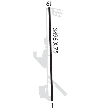
| Lat: N 3956.1 Long: W 07448.4 Elev: 49 Var: +13 Longest Runway: 3496 | ||
| CTAF: 122.8 | ||
| ||||||||||||||||||||||||||||||||||||||||||||
| ||||||||||||||||||||||||||||||||||||||||||||
| Rwy | Rwy | |||||||
| 3496x75 | 3496' | 3496x75 | 3496' | |||||
| Runway ID | Single Wheel | Double Wheel | Double Tandem Wheel | Dual Double Wheel |
| 01/19 | N/A | N/A | N/A | N/A |
| These numbers are Advisory and are not limits. The Airport Manager should have more accurate Weight Limits | ||||
 Airport Diagram might not be current. | |
| Facility Name: | FLYING W |
| City Name: | LUMBERTON |
| County: | BURLINGTON |
| State abbrev: | NJ |
| State Name: | NEW JERSEY |
| Ownership: | PRIVATELY OWNED |
| Use: | OPEN TO THE PUBLIC |
| Owner's Name: | CAVE HOLDINGS-FLYING W, LLC |
| Address: | 60 FOSTERTOWN RD |
| MEDFORD, NJ 08055 | |
| Owner's Phone: | 609-261-7880 |
| Manager's Name: | MINDY KIMBALL |
| Address: | 60 FOSTERTOWN RD |
| MEDFORD, NJ 08055 | |
| Phone: | 609-267-7673 |
| FAA Region: | EASTERN |
| FAA Field Office: | HAR |
| Date | Sunrise | Sunset |
|---|---|---|
| 02/10/25 Monday | 6:58 | 17:29 |
| 02/11/25 Tuesday | 6:57 | 17:30 |
| 02/12/25 Wednesday | 6:56 | 17:32 |
| 02/13/25 Thursday | 6:55 | 17:33 |
| 02/14/25 Friday | 6:54 | 17:34 |
| 02/15/25 Saturday | 6:52 | 17:35 |
| 02/16/25 Sunday | 6:51 | 17:36 |
| 02/17/25 Monday | 6:50 | 17:37 |
| 02/18/25 Tuesday | 6:49 | 17:39 |
| 02/19/25 Wednesday | 6:47 | 17:40 |
| 02/20/25 Thursday | 6:46 | 17:41 |
| 02/21/25 Friday | 6:44 | 17:42 |
| 02/22/25 Saturday | 6:43 | 17:43 |
| 02/23/25 Sunday | 6:42 | 17:44 |
| Airport Attendance Schedule | APR-OCT 7 Days A Week 0700-2100, NOV-MAR 7 Days A Week 0700-1900 |
| Airport Status | OPERATIONAL (This Status can change at any time - please check NOTAMS) |
| Airport Lighting Schedule | ACTVT MIRL, PAPI, REIL AND TWY LGTS - CTAF. |
| Airport Storage Available | Tie Downs |
| Extra Services Available | Flight Instruction, Aircraft Rental |
| Wind Indicator | YES - (lighted) |
| Control Tower | NO |
| CTAF Frequency | 122.800 |
| Unicom Frequency | 122.800 |
| Rotating Beacon Color | WG |
| Segmented Circle | YES |
| Landing Fee | NO |
| Airport Inspected | STATE - performed by STATE AERONAUTICAL PERSONNEL |
| Inspection Date | 12/06/2023 |
| Type of Fuel Available | Grade 100LL, JET A (freeze point -40C) |
| Airframe Repair Service | MINOR |
| Power Plant Repair Service | MINOR |
| Latitude | N3956.1 |
| Longitude | W07448.4 (ESTIMATED) |
| Arpt Elevation | 49ft (SURVEYED) |
| Magnetic Variation | 13W |
| 1 miles SW | of LUMBERTON |
| Traffic Pattern Altitude | |
| Sectional Chart | WASHINGTON |
| Operations (Reported) | Yearly | Avg. Daily |
|---|---|---|
| General Aviation Transient | 0 | 0 |
| General Aviation Local | 0 | 0 |
| Air Taxi | 0 | 0 |
| Commerical | 0 | 0 |
| Commuter | 0 | 0 |
| Military | 0 | 0 |
| Aircraft based on Field | |
|---|---|
| General Aviation Singles | 0 |
| General Aviation Multi | 0 |
| Jet Aircraft | 0 |
| General Aviation Helicopters | 0 |
| Military Aircraft | 0 |
| Gliders | 0 |
| Ultralights | 0 |
| FSS on field | NO |
| FSS tie-in | MILLVILLE |
| FSS Phone | 1-800-WX-BRIEF |
| Who issues Notams | MIV |
| Notam D service at airport | YES |
| ARTCC Name | WASHINGTON |
| Airport Certification | |
| Aircraft Rescue & Firefighting Index | None |
| Airport of Entry | No |
| Custom Landing Rights | No |
| Joint Civil/Military | No |
| Military Landing rights | No |
| EAST-WEST RAVINE CROSSES EXTD CNTRLN RWY 01, 100 FT FM THLD. |
| DEEP RETENTION POND 23 FT WEST OF PARALLEL TWY CNTRLN, NORTH OF OPS BLDG. |
| FOR CD CTC MC GUIRE APCH AT 609-754-2767. |
| DEER & BIRDS ON & INVOF ARPT. |
Airport Communications & Frequencies:
| ||||||||||||||
| Runway: 01 | Runway: 19 | ||
| Mag heading: | 11° | Mag heading: | 191° |
| Rwy Slope: | .40% Up | Rwy Slope: | -.40% Down |
| Approach: | Approach: | ||
| Pattern: | Right Traffic | Pattern: | Left Traffic |
| Markings: | NONPRECISION INSTRUMENT | Markings: | NONPRECISION INSTRUMENT |
| Marking Condition: | GOOD | Marking Condition: | GOOD |
| Arresting Dev: | Arresting Dev: | ||
| Lat & Long: | N3955.8 W07448.4 | Lat. & Long.: | N3956.3 W07448.4 |
| Elev: | 35.0 ft. MSL | Elev: | 49.1 ft. MSL |
| TCH: | 26 ft. AGL | TCH: | 22 ft. AGL |
| Visual Glide Path: | 3.50 degrees | Visual Glide Path: | 3.20 degrees |
| Displaced Threshold: | No | Displaced Threshold: | No |
| Touchdown Zone: | YES | Touchdown Zone: | YES |
| Touchdown Elev.: | 49.3 feet | Touchdown Elev.: | 49.3 feet |
| Visual Glide Slope: | 2-Light PAPI on LEFT side of Runway | Visual Glide Slope: | 2-Light PAPI on LEFT side of Runway |
| RVR Equipment: | RVR Equipment: | ||
| RVV Equipment: | NO | RVV Equipment: | NO |
| Approach Lights: | Approach Lights: | ||
| REIL: | YES; REILS INOP. | REIL: | YES; REILS INOP. |
| Centerline Lights: | NO | Centerline Lights: | NO |
| Touchdown lights: | NO | Touchdown lights: | NO |
| Runway Category: | Runway with a Visual Approach | Runway Category: | Runway with a Visual Approach |
| Declared Distances: | Declared Distances: | ||
| Obstructions: | TREES | Obstructions: | |
| Marked: | NOT Marked/Lighted | Marked: | |
| Clearance slope: | Clearance slope: | 50:1 | |
| Obstruction height: | 89 feet AGL | Obstruction height: | |
| Dist. from runway: | 262 feet | Dist. from runway: | |
| Centerline offset: | 169 right of centerline | Centerline offset: | |
| Comments: | TREE, +42 FT HIGH, 43 FT FM THLD, 102 FT R. | Comments: |
Thanks for using FltPlan.com
all rights reserved © 1999-2025 by Flight Plan LLC