
| WITTMAN RGNL OSHKOSH WI |
| |
| Lat: N 4359.1 Long: W 08833.4 Elev: 809 Var: +03 Longest Runway: 8002 | ||
| Dept. ATIS: 125.9 Arr. ATIS: 125.9 Ground: 132.3 Tower: 118.5 | ||
| ||||||
| ||||||
|
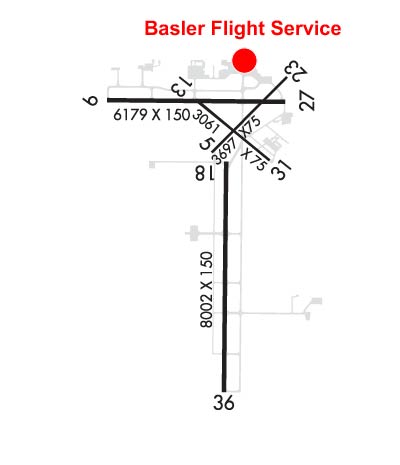
| Rwy | Rwy | |||||||
| 3424x75 | 3424' | 3424x75 | 3424' | |||||
| 6179x150 | 6179' | 6179x150 | 5648' | |||||
| 3061x75 | 3061' | 3061x75 | 3061' | |||||
| 8002x150 | 8002' | 8002x150 | 8002' | 110.50 - 003° | ||||
| Runway ID | Single Wheel | Double Wheel | Double Tandem Wheel | Dual Double Wheel |
| 05/23 | N/A | N/A | N/A | N/A |
| 09/27 | 75,000 | 125,000 | 185,000 | N/A |
| 13/31 | N/A | N/A | N/A | N/A |
| 18/36 | 65,000 | 85,000 | 130,000 | N/A |
| These numbers are Advisory and are not limits. The Airport Manager should have more accurate Weight Limits | ||||
 Airport Diagram might not be current. | |
| Facility Name: | WITTMAN RGNL |
| City Name: | OSHKOSH |
| County: | WINNEBAGO |
| State abbrev: | WI |
| State Name: | WISCONSIN |
| Ownership: | PUBLICLY OWNED |
| Use: | OPEN TO THE PUBLIC |
| Owner's Name: | WINNEBAGO COUNTY |
| Address: | 415 JACKSON ST |
| OSHKOSH, WI 54901 | |
| Owner's Phone: | 920-236-4930 |
| Manager's Name: | JAMES SCHELL |
| Address: | 525 W 20TH AVE; EMAIL ADDRESS: JSCHELL@WINNEBAGOCOUNTYWI.GOV (ALL LOWER CASE). |
| OSHKOSH, WI 54902 | |
| Phone: | 920-236-4930 |
| FAA Region: | GREAT LAKES |
| FAA Field Office: | CHI |
| Date | Sunrise | Sunset |
|---|---|---|
| 03/12/25 Wednesday | 7:12 | 18:57 |
| 03/13/25 Thursday | 7:11 | 18:58 |
| 03/14/25 Friday | 7:09 | 18:59 |
| 03/15/25 Saturday | 7:07 | 19:00 |
| 03/16/25 Sunday | 7:05 | 19:01 |
| 03/17/25 Monday | 7:03 | 19:03 |
| 03/18/25 Tuesday | 7:02 | 19:04 |
| 03/19/25 Wednesday | 7:00 | 19:05 |
| 03/20/25 Thursday | 6:58 | 19:06 |
| 03/21/25 Friday | 6:56 | 19:08 |
| 03/22/25 Saturday | 6:54 | 19:09 |
| 03/23/25 Sunday | 6:52 | 19:10 |
| 03/24/25 Monday | 6:51 | 19:11 |
| 03/25/25 Tuesday | 6:49 | 19:13 |
| Airport Attendance Schedule | 7 Days A Week 0700-2000; FOR ARPT ATTENDANT OTR HRS CALL 920-236-7827. |
| Airport Status | OPERATIONAL (This Status can change at any time - please check NOTAMS) |
| Airport Lighting Schedule | ACTVT MALSR RWY 36; HIRL RWY 09/27 - CTAF. HIRL 18/36 PRESET ON MED INTST, TO INCR INTST & ACTVT - CTAF. PAPI RWY 09, 27, 18 & 36 OPR CONSLY. |
| Airport Storage Available | Tie Downs, Hanger |
| Extra Services Available | Air Freight, Avionics, Cargo Handling, Charter, Flight Instruction, Aircraft Rental, Aircraft Sales |
| Wind Indicator | YES - (lighted) |
| Control Tower | YES |
| CTAF Frequency | 118.500 |
| Unicom Frequency | 122.950 |
| Rotating Beacon Color | WG |
| Segmented Circle | NO |
| Landing Fee | NO |
| Airport Inspected | FEDERAL - performed by STATE AERONAUTICAL PERSONNEL |
| Inspection Date | 09/15/2022 |
| Type of Fuel Available | Grade 100LL, JET A; -A+A+ AND 100LL AVBL 0700-1900++ MON-FRI, 0800-1700++ SAT-SUN, C920-236-7827 (AFTER HRS FEE $50). |
| Airframe Repair Service | MAJOR |
| Power Plant Repair Service | MAJOR |
| Latitude | N4359.1 |
| Longitude | W08833.4 (ESTIMATED) |
| Arpt Elevation | 808ft (SURVEYED) |
| Magnetic Variation | 03W |
| 2 miles S | of OSHKOSH |
| Traffic Pattern Altitude | |
| Sectional Chart | CHICAGO |
| Operations (Reported) | Yearly | Avg. Daily |
|---|---|---|
| General Aviation Transient | 0 | 0 |
| General Aviation Local | 0 | 0 |
| Air Taxi | 0 | 0 |
| Commerical | 0 | 0 |
| Commuter | 0 | 0 |
| Military | 0 | 0 |
| Aircraft based on Field | |
|---|---|
| General Aviation Singles | 0 |
| General Aviation Multi | 0 |
| Jet Aircraft | 0 |
| General Aviation Helicopters | 0 |
| Military Aircraft | 0 |
| Gliders | 0 |
| Ultralights | 0 |
| FSS on field | NO |
| FSS tie-in | GREEN BAY |
| FSS Phone | 1-800-WX-BRIEF |
| Who issues Notams | OSH |
| Notam D service at airport | YES |
| ARTCC Name | CHICAGO |
| Airport Certification | |
| Aircraft Rescue & Firefighting Index | None |
| Airport of Entry | No |
| Custom Landing Rights | No |
| Joint Civil/Military | No |
| Military Landing rights | YES |
| NATIONAL PLAN OF INTEGRATED AIRPORT SYSTEMS (NPIAS) |
| GRANT AGREEMENTS UNDER FAAP/ADAP/AIP |
| ASSURANCES PURSUANT TO TITLE VI, CIVIL RIGHTS ACT OF 1964 |
| AGREEMENT UNDER DLAND OR DCLA HAS EXPIRED. |
| FOR CD IF UNA TO CTC ON FSS FREQ, CTC CHICAGO ARTCC AT 630-906-8921. |
| SFC CONDS NOT MONTRD BTWN 2200 - 0500 HRS. |
| BIRDS ON & INVOF ARPT. |
| RWYS 13/31, 05/23 & TWYS C, H, P NOT AVBL TO ACFT WITH MORE THAN 30 PSGR SEATS. |
| RY 23 & RY 27 APCH ENDS ARE CLOSELY ALIGNED. VERIFY CORRECT RY AND COMPASS HEADING PRIOR TO DEP. |
| RWY 05/2 3 MAXIMUM WEIGHT BEARING CAPACITY FOR ANY ACFT IS 50000 LBS. |
| RWY 13/3 1 MAXIMUM WEIGHT BEARING CAPACITY FOR ANY ACFT IS 50000 LBS. |
Airport Communications & Frequencies:
| ||||||||||||||||||||||||||
| Runway: 05 | Runway: 23 | ||
| Mag heading: | 48° | Mag heading: | 228° |
| Rwy Slope: | -.44% Down | Rwy Slope: | .44% Up |
| Approach: | Approach: | ||
| Pattern: | Left Traffic | Pattern: | Left Traffic |
| Markings: | BASIC | Markings: | BASIC |
| Marking Condition: | GOOD | Marking Condition: | GOOD |
| Arresting Dev: | Arresting Dev: | ||
| Lat & Long: | N4359.2 W08833.5 | Lat. & Long.: | N4359.6 W08832.9 |
| Elev: | 790.3 ft. MSL | Elev: | 775.2 ft. MSL |
| TCH: | TCH: | ||
| Visual Glide Path: | Visual Glide Path: | ||
| Displaced Threshold: | No | Displaced Threshold: | No |
| Touchdown Zone: | YES | Touchdown Zone: | YES |
| Touchdown Elev.: | 790.4 feet | Touchdown Elev.: | 788.0 feet |
| Visual Glide Slope: | Visual Glide Slope: | ||
| RVR Equipment: | RVR Equipment: | ||
| RVV Equipment: | NO | RVV Equipment: | NO |
| Approach Lights: | Approach Lights: | ||
| REIL: | NO | REIL: | NO |
| Centerline Lights: | NO | Centerline Lights: | NO |
| Touchdown lights: | NO | Touchdown lights: | NO |
| Runway Category: | Runway with a Visual Approach | Runway Category: | Runway with a Visual Approach |
| Declared Distances: | Declared Distances: |
| Runway: 09 | Runway: 27 | ||
| Mag heading: | 94° | Mag heading: | 274° |
| Rwy Slope: | -.35% Down | Rwy Slope: | .35% Up |
| Approach: | Approach: | ||
| Pattern: | Left Traffic | Pattern: | Left Traffic |
| Markings: | NONPRECISION INSTRUMENT | Markings: | NONPRECISION INSTRUMENT |
| Marking Condition: | GOOD | Marking Condition: | GOOD |
| Arresting Dev: | Arresting Dev: | ||
| Lat & Long: | N4359.5 W08834.3 | Lat. & Long.: | N4359.5 W08832.9 |
| Elev: | 797.5 ft. MSL | Elev: | 775.8 ft. MSL |
| TCH: | 50 ft. AGL | TCH: | 47 ft. AGL |
| Visual Glide Path: | 3.00 degrees | Visual Glide Path: | 3.00 degrees |
| Displaced Threshold: | No | Displaced Threshold: | 531 feet |
| Touchdown Zone: | YES | Touchdown Zone: | YES |
| Touchdown Elev.: | 797.5 feet | Touchdown Elev.: | 785.8 feet |
| Visual Glide Slope: | 4-Light PAPI on LEFT side of Runway | Visual Glide Slope: | 4-Light PAPI on LEFT side of Runway |
| RVR Equipment: | RVR Equipment: | ||
| RVV Equipment: | NO | RVV Equipment: | NO |
| Approach Lights: | Approach Lights: | ||
| REIL: | NO | REIL: | YES |
| Centerline Lights: | NO | Centerline Lights: | NO |
| Touchdown lights: | NO | Touchdown lights: | NO |
| Runway Category: | D | Runway Category: | D |
| Declared Distances: | TORA:6179' TODA:6179' ASDA:5648' LDA:5648' | Declared Distances: | TORA:6179' TODA:6179' ASDA:6179' LDA:5648' |
| Obstructions: | Obstructions: | TREE | |
| Marked: | Marked: | NOT Marked/Lighted | |
| Clearance slope: | 34:1 | Clearance slope: | 14:1; APCH RATIO 34:1 TO DSPLCD THR. |
| Obstruction height: | Obstruction height: | 39 feet AGL | |
| Dist. from runway: | Dist. from runway: | 750 feet | |
| Centerline offset: | Centerline offset: | 160 feet right of centerline | |
| Comments: | Comments: |
| Runway: 13 | Runway: 31 | ||
| Mag heading: | 132° | Mag heading: | 312° |
| Rwy Slope: | -.02% Down | Rwy Slope: | .02% Up |
| Approach: | Approach: | ||
| Pattern: | Left Traffic | Pattern: | Left Traffic |
| Markings: | BASIC | Markings: | BASIC |
| Marking Condition: | GOOD | Marking Condition: | GOOD |
| Arresting Dev: | Arresting Dev: | ||
| Lat & Long: | N4359.5 W08833.6 | Lat. & Long.: | N4359.2 W08833.0 |
| Elev: | 781.7 ft. MSL | Elev: | 781.2 ft. MSL |
| TCH: | TCH: | ||
| Visual Glide Path: | Visual Glide Path: | ||
| Displaced Threshold: | No | Displaced Threshold: | No |
| Touchdown Zone: | YES | Touchdown Zone: | YES |
| Touchdown Elev.: | 784.4 feet | Touchdown Elev.: | 784.4 feet |
| Visual Glide Slope: | Visual Glide Slope: | ||
| RVR Equipment: | RVR Equipment: | ||
| RVV Equipment: | NO | RVV Equipment: | NO |
| Approach Lights: | Approach Lights: | ||
| REIL: | NO | REIL: | NO |
| Centerline Lights: | NO | Centerline Lights: | NO |
| Touchdown lights: | NO | Touchdown lights: | NO |
| Runway Category: | Runway with a Visual Approach | Runway Category: | Runway with a Visual Approach |
| Declared Distances: | Declared Distances: | ||
| Obstructions: | Obstructions: | ROAD | |
| Marked: | Marked: | NOT Marked/Lighted | |
| Clearance slope: | 20:1 | Clearance slope: | 1:1 |
| Obstruction height: | Obstruction height: | 15 feet AGL | |
| Dist. from runway: | Dist. from runway: | 217 feet | |
| Centerline offset: | Centerline offset: | 127 feet right of centerline | |
| Comments: | Comments: |
| Runway: 18 | Runway: 36 | ||
| Mag heading: | 184° | Mag heading: | 4° |
| Rwy Slope: | .23% Up | Rwy Slope: | -.23% Down |
| Approach: | Approach: | ILS | |
| Pattern: | Left Traffic | Pattern: | Left Traffic |
| Markings: | PRECISION INSTRUMENT | Markings: | PRECISION INSTRUMENT |
| Marking Condition: | GOOD | Marking Condition: | GOOD |
| Arresting Dev: | Arresting Dev: | ||
| Lat & Long: | N4359.1 W08833.4 | Lat. & Long.: | N4357.8 W08833.4 |
| Elev: | 789.6 ft. MSL | Elev: | 808.4 ft. MSL |
| TCH: | 47 ft. AGL | TCH: | 52 ft. AGL |
| Visual Glide Path: | 3.00 degrees | Visual Glide Path: | 3.00 degrees |
| Displaced Threshold: | No | Displaced Threshold: | No |
| Touchdown Zone: | YES | Touchdown Zone: | YES |
| Touchdown Elev.: | 793.7 feet | Touchdown Elev.: | 808.5 feet |
| Visual Glide Slope: | 4-Light PAPI on LEFT side of Runway | Visual Glide Slope: | 4-Light PAPI on LEFT side of Runway |
| RVR Equipment: | ROLLOUT | RVR Equipment: | TOUCHDOWN |
| RVV Equipment: | NO | RVV Equipment: | NO |
| Approach Lights: | Approach Lights: | MALSR - 1,400 foot medium intensity approach lighting system with runway alignment indicator lights | |
| REIL: | YES | REIL: | NO |
| Centerline Lights: | NO | Centerline Lights: | NO |
| Touchdown lights: | NO | Touchdown lights: | NO |
| Runway Category: | D | Runway Category: | Precision Instrument Runway |
| Declared Distances: | Declared Distances: | ||
| Obstructions: | ANT | Obstructions: | |
| Marked: | NOT Marked/Lighted | Marked: | |
| Clearance slope: | 23:1 | Clearance slope: | 50:1 |
| Obstruction height: | 15 feet AGL | Obstruction height: | |
| Dist. from runway: | 550 feet | Dist. from runway: | |
| Centerline offset: | 250 left of centerline | Centerline offset: | |
| Comments: | Comments: |
Thanks for using FltPlan.com
all rights reserved © 1999-2025 by Flight Plan LLC
