
| MERLE K (MUDHOLE) SMITH CORDOVA AK |
| |
| Lat: N 6029.5 Long: W 14528.7 Elev: 53 Var: -19 Longest Runway: 7500 | ||
| AWOS: 134.80 CTAF: 123.6 | ||
| ||||||||||||||||||||||||||||||||
| ||||||||||||||||||||||||||||||||
| ||||||||||||||||||||||||||||||||
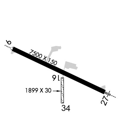
| Rwy | Rwy | |||||||
| 7500x150 | 7500' | 7500x150 | 7500' | 110.70 - 275° | ||||
| 1934x30 | 1934' | 1934x30 | 1934' | |||||
| Runway ID | Single Wheel | Double Wheel | Double Tandem Wheel | Dual Double Wheel |
| 09/27 | 90,000 | 153,000 | 280,000 | N/A |
| 16/34 | N/A | N/A | N/A | N/A |
| These numbers are Advisory and are not limits. The Airport Manager should have more accurate Weight Limits | ||||
 Airport Diagram might not be current. | |
| Facility Name: | MERLE K (MUDHOLE) SMITH |
| City Name: | CORDOVA |
| County: | VALDEZ-CORDOVA |
| State abbrev: | AK |
| State Name: | ALASKA |
| Ownership: | PUBLICLY OWNED |
| Use: | OPEN TO THE PUBLIC |
| Owner's Name: | ALASKA DOT&PF NORTHERN REGION |
| Address: | 2301 PEGER ROAD |
| FAIRBANKS, AK 99709 | |
| Owner's Phone: | 907-451-5250 |
| Manager's Name: | MATTHEW MYSZKA |
| Address: | BOX 598 |
| CORDOVA, AK 99574 | |
| Phone: | 907-424-3202 |
| FAA Region: | ALASKA |
| FAA Field Office: | NONE |
| Date | Sunrise | Sunset |
|---|---|---|
| 04/17/25 Thursday | 6:18 | 21:07 |
| 04/18/25 Friday | 6:15 | 21:09 |
| 04/19/25 Saturday | 6:12 | 21:12 |
| 04/20/25 Sunday | 6:09 | 21:14 |
| 04/21/25 Monday | 6:06 | 21:17 |
| 04/22/25 Tuesday | 6:03 | 21:19 |
| 04/23/25 Wednesday | 6:00 | 21:22 |
| 04/24/25 Thursday | 5:57 | 21:25 |
| 04/25/25 Friday | 5:54 | 21:27 |
| 04/26/25 Saturday | 5:51 | 21:30 |
| 04/27/25 Sunday | 5:48 | 21:32 |
| 04/28/25 Monday | 5:45 | 21:35 |
| 04/29/25 Tuesday | 5:43 | 21:37 |
| 04/30/25 Wednesday | 5:40 | 21:40 |
| Airport Attendance Schedule | 7 Days A Week 0600-1630 |
| Airport Status | OPERATIONAL (This Status can change at any time - please check NOTAMS) |
| Airport Lighting Schedule | ACTVT MALSR RWY 27; ODALS RWY 09; VASI RWYS 09 & 27; HIRL RWY 09/27 - CTAF. |
| Airport Storage Available | Tie Downs |
| Extra Services Available | Cargo Handling |
| Wind Indicator | YES - (lighted) |
| Control Tower | NO |
| CTAF Frequency | 123.600 |
| Unicom Frequency | |
| Rotating Beacon Color | WG |
| Segmented Circle | YES |
| Landing Fee | NO |
| Airport Inspected | FEDERAL - performed by FAA AIRPORTS FIELD PERSONNEL |
| Inspection Date | 08/28/2024 |
| Type of Fuel Available | None |
| Airframe Repair Service | None |
| Power Plant Repair Service | None |
| Latitude | N6029.5 |
| Longitude | W14528.7 (ESTIMATED) |
| Arpt Elevation | 53ft (SURVEYED) |
| Magnetic Variation | 19E |
| 11 miles SE | of CORDOVA |
| Traffic Pattern Altitude | |
| Sectional Chart | ANCHORAGE |
| Operations (Reported) | Yearly | Avg. Daily |
|---|---|---|
| General Aviation Transient | 0 | 0 |
| General Aviation Local | 0 | 0 |
| Air Taxi | 0 | 0 |
| Commerical | 0 | 0 |
| Commuter | 0 | 0 |
| Military | 0 | 0 |
| Aircraft based on Field | |
|---|---|
| General Aviation Singles | 0 |
| General Aviation Multi | 0 |
| Jet Aircraft | 0 |
| General Aviation Helicopters | 0 |
| Military Aircraft | 0 |
| Gliders | 0 |
| Ultralights | 0 |
| FSS on field | NO |
| FSS tie-in | JUNEAU |
| FSS Phone | 1-800-866-297-2236 |
| Who issues Notams | CDV |
| Notam D service at airport | YES |
| ARTCC Name | ANCHORAGE |
| Airport Certification | AIRPORT RECEIVING SCHEDULED AIR CARRIER SERVICE FROM CARRIERS CERTIFICATED BY THE CIVIL AERONAUTICS BOARD; CLSD TO ACR OPS MORE THAN 30 PAX SEATS EXC 24 HR PPR IN WRITING - AMGR BOX 598 CORDOVA AK 99574. |
| Aircraft Rescue & Firefighting Index | AIRPORT HAS A CERTIFICATE UNDER CFR PART 139 |
| Airport of Entry | No |
| Custom Landing Rights | No |
| Joint Civil/Military | No |
| Military Landing rights | YES |
| NATIONAL PLAN OF INTEGRATED AIRPORT SYSTEMS (NPIAS) |
| GRANT AGREEMENTS UNDER FAAP/ADAP/AIP |
| SURPLUS PROPERTY AGREEMENT UNDER PUBLIC LAW 289 |
| CONVEYANCE UNDER SCETION 16, FEDERAL AIRPORT ACT OF 1946 OR SECTION 23, AIRPORT AND AIRWAY DEVELOPMENT ACT OF 1970 |
| ASSURANCES PURSUANT TO TITLE VI, CIVIL RIGHTS ACT OF 1964 |
| ERRATIC WINDS. |
| ARPT SAND LRGR GRADATION THAN FAA RCMDD/SEE AC150/5200-30. |
| WX CAMERA AVBL ON INTERNET AT HTTPS://WEATHERCAMS.FAA.GOV |
| TSA REGULATED ARPT; SEE 49 CFR 1542. GATES & DOORS MUST BE SECURED ALL TIMES; INFO - AMGR. |
| ARPT SVCS & COND RPTG AVBL ONLY DURG MAINT DUTY HR; AFT HR - AMGR. BTN 1600 & 0700 SNOW REMOVAL & DEICE NA. RWY COND RPT REFLECTS DAY OPS ONLY. |
| MOOSE & BIRDS INVOF ARPT & RWYS. |
| ARFF EQUIP DURG ACR ACT ONLY. |
| CORDOVA WX - 424-7614 OR 122.65. |
| RWY 16/3 4 ACR OPS MORE THAN 30 PAX SEATS NA. |
| RWY 09/2 7 PCR VALUE: 977/F/A/X/T |
Airport Communications & Frequencies:
| |||||||
| Runway: 09 | Runway: 27 | ||
| Mag heading: | 95° | Mag heading: | 275° |
| Rwy Slope: | .02% Up | Rwy Slope: | -.02% Down |
| Approach: | Approach: | ILS/DME | |
| Pattern: | Right Traffic | Pattern: | Left Traffic |
| Markings: | PRECISION INSTRUMENT | Markings: | PRECISION INSTRUMENT |
| Marking Condition: | FAIR | Marking Condition: | FAIR |
| Arresting Dev: | Arresting Dev: | EMAS; ENGINEERED MATERIALS ARRESTING SYSTEM (EMAS) 250 FT IN LENGTH BY 170 FT IN WIDTH LCTD DER 27. | |
| Lat & Long: | N6029.8 W14529.8 | Lat. & Long.: | N6029.3 W14527.5 |
| Elev: | 41.6 ft. MSL | Elev: | 43.0 ft. MSL |
| TCH: | 41 ft. AGL | TCH: | 57 ft. AGL |
| Visual Glide Path: | 3.00 degrees | Visual Glide Path: | 3.00 degrees |
| Displaced Threshold: | No | Displaced Threshold: | No |
| Touchdown Zone: | YES | Touchdown Zone: | YES |
| Touchdown Elev.: | 49.6 feet | Touchdown Elev.: | 52.5 feet |
| Visual Glide Slope: | 4-BOX VASI ON LEFT SIDE OF RUNWAY; RWY 09 VASI UNUSBL BYD 4 NM DUE TO OBSTS. | Visual Glide Slope: | 4-BOX VASI ON LEFT SIDE OF RUNWAY |
| RVR Equipment: | TOUCHDOWN-ROLLOUT | RVR Equipment: | TOUCHDOWN-ROLLOUT |
| RVV Equipment: | YES | RVV Equipment: | YES |
| Approach Lights: | ODALS - omnidirectional approach lighting system | Approach Lights: | MALSR - 1,400 foot medium intensity approach lighting system with runway alignment indicator lights |
| REIL: | NO | REIL: | NO |
| Centerline Lights: | NO | Centerline Lights: | NO |
| Touchdown lights: | NO | Touchdown lights: | NO |
| Runway Category: | Runway with a Visual Approach | Runway Category: | Precision Instrument Runway |
| Declared Distances: | TORA:7500' TODA:7500' ASDA:7500' LDA:7500' | Declared Distances: | TORA:7500' TODA:7500' ASDA:7500' LDA:7500' |
| Obstructions: | ANT | Obstructions: | POLE |
| Marked: | LIGHTED | Marked: | LIGHTED |
| Clearance slope: | 20:1 | Clearance slope: | 12:1 |
| Obstruction height: | 20 feet AGL | Obstruction height: | 25 feet AGL |
| Dist. from runway: | 600 feet | Dist. from runway: | 500 feet |
| Centerline offset: | 250 left of centerline | Centerline offset: | 450 feet right of centerline |
| Comments: | Comments: |
| Runway: 16 | Runway: 34 | ||
| Mag heading: | 162° | Mag heading: | 342° |
| Rwy Slope: | -.56% Down | Rwy Slope: | .56% Up |
| Approach: | Approach: | ||
| Pattern: | Left Traffic | Pattern: | Left Traffic |
| Markings: | NONE | Markings: | NONE |
| Marking Condition: | POOR; 36 IN ORANGE CONES MAY 1 - OCT 25. | Marking Condition: | POOR; 36 IN ORANGE CONES MAY 1 - OCT 25. |
| Arresting Dev: | Arresting Dev: | ||
| Lat & Long: | N6029.5 W14528.6 | Lat. & Long.: | N6029.1 W14528.6 |
| Elev: | 49.5 ft. MSL | Elev: | 38.6 ft. MSL |
| TCH: | TCH: | ||
| Visual Glide Path: | Visual Glide Path: | ||
| Displaced Threshold: | No | Displaced Threshold: | No |
| Touchdown Zone: | YES | Touchdown Zone: | YES |
| Touchdown Elev.: | 49.5 feet | Touchdown Elev.: | 49.5 feet |
| Visual Glide Slope: | Visual Glide Slope: | ||
| RVR Equipment: | RVR Equipment: | ||
| RVV Equipment: | NO | RVV Equipment: | NO |
| Approach Lights: | Approach Lights: | ||
| REIL: | NO | REIL: | NO |
| Centerline Lights: | NO | Centerline Lights: | NO |
| Touchdown lights: | NO | Touchdown lights: | NO |
| Runway Category: | Runway with a Visual Approach | Runway Category: | Runway with a Visual Approach |
| Declared Distances: | Declared Distances: | ||
| Obstructions: | Obstructions: | TREES | |
| Marked: | Marked: | NOT Marked/Lighted | |
| Clearance slope: | Clearance slope: | 5:1 | |
| Obstruction height: | Obstruction height: | 70 feet AGL | |
| Dist. from runway: | Dist. from runway: | 350 feet | |
| Centerline offset: | Centerline offset: | 150 feet left of centerline | |
| Comments: | Comments: |
Thanks for using FltPlan.com
all rights reserved © 1999-2025 by Flight Plan LLC