
| RALPH WIEN MEMORIAL KOTZEBUE AK |
| |
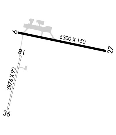
| Lat: N 6653.1 Long: W 16235.9 Elev: 15 Var: -11 Longest Runway: 6300 | ||
| Dept. ATIS: 135.45 Arr. ATIS: 135.45 AWOS: 135.45 CTAF: 123.6 | ||
| ||||||||||||||||||||||||||||||||
| ||||||||||||||||||||||||||||||||
| ||||||||||||||||||||||||||||||||
| ||||||||||||||||||||||||||||||||
| Rwy | Rwy | |||||||
| 6300x150 | 5900' | 110.70 - 088° | 6300x150 | 6300' | ||||
| 3876x90 | 3876' | 3876x90 | 3876' | |||||
| Runway ID | Single Wheel | Double Wheel | Double Tandem Wheel | Dual Double Wheel |
| 09/27 | 100,000 | 128,000 | 240,000 | N/A |
| 18/36 | N/A | N/A | N/A | N/A |
| These numbers are Advisory and are not limits. The Airport Manager should have more accurate Weight Limits | ||||
 Airport Diagram might not be current. | |
| Facility Name: | RALPH WIEN MEML |
| City Name: | KOTZEBUE |
| County: | NORTHWEST ARCTIC |
| State abbrev: | AK |
| State Name: | ALASKA |
| Ownership: | PUBLICLY OWNED |
| Use: | OPEN TO THE PUBLIC |
| Owner's Name: | ALASKA DOT&PF NORTHERN REGION |
| Address: | 2301 PEGER RD |
| FAIRBANKS, AK 99701 | |
| Owner's Phone: | 907-451-5250 |
| Manager's Name: | ALVIN WERNEKE |
| Address: | BOX 55 |
| KOTZEBUE, AK 99752 | |
| Phone: | 907-442-3147 |
| FAA Region: | ALASKA |
| FAA Field Office: | NONE |
| Date | Sunrise | Sunset |
|---|---|---|
| 09/24/21 Friday | 8:39 | 20:44 |
| 09/25/21 Saturday | 8:42 | 20:40 |
| 09/26/21 Sunday | 8:45 | 20:36 |
| 09/27/21 Monday | 8:49 | 20:32 |
| 09/28/21 Tuesday | 8:52 | 20:28 |
| 09/29/21 Wednesday | 8:55 | 20:24 |
| 09/30/21 Thursday | 8:59 | 20:20 |
| 10/01/21 Friday | 9:02 | 20:16 |
| 10/02/21 Saturday | 9:05 | 20:12 |
| 10/03/21 Sunday | 9:09 | 20:08 |
| 10/04/21 Monday | 9:12 | 20:04 |
| 10/05/21 Tuesday | 9:15 | 20:00 |
| 10/06/21 Wednesday | 9:19 | 19:56 |
| 10/07/21 Thursday | 9:22 | 19:52 |
| Airport Attendance Schedule | WED-MON 0600-2000, TUE 0600-2100 |
| Airport Status | OPERATIONAL (This Status can change at any time - please check NOTAMS) |
| Airport Lighting Schedule | HIRL RWY 09/27 & MIRL RWY 18/36 OPER 0700-0000 OTR HRS ACTVT - CTAF. ACTVT REILS RWY 09 & 27 - CTAF. PAPI RWY 09, 27 OPR CONTINUOUSLY. |
| Airport Storage Available | Hanger |
| Extra Services Available | Cargo Handling |
| Wind Indicator | YES - (lighted) |
| Control Tower | NO |
| CTAF Frequency | 123.600 |
| Unicom Frequency | 122.800 |
| Rotating Beacon Color | CLEAR-GREEN (Light Land Airport) |
| Segmented Circle | YES |
| Landing Fee | NO |
| Airport Inspected | FEDERAL - performed by FAA AIRPORTS FIELD PERSONNEL |
| Inspection Date | 07/01/2021 |
| Type of Fuel Available | Grade 100, JET A (freeze point -40C) |
| Airframe Repair Service | MINOR |
| Power Plant Repair Service | MINOR |
| Latitude | N6653.1 |
| Longitude | W16235.9 (ESTIMATED) |
| Arpt Elevation | 15ft (SURVEYED) |
| Magnetic Variation | 11E |
| 1 miles S | of KOTZEBUE |
| Traffic Pattern Altitude | |
| Sectional Chart | NOME |
| Operations (Reported) | Yearly | Avg. Daily |
|---|---|---|
| General Aviation Transient | 30000 | 82 |
| General Aviation Local | 7000 | 19 |
| Air Taxi | 20000 | 55 |
| Commerical | 2000 | 5 |
| Commuter | 0 | 0 |
| Military | 1000 | 3 |
| Aircraft based on Field | |
|---|---|
| General Aviation Singles | 37 |
| General Aviation Multi | 6 |
| Jet Aircraft | 0 |
| General Aviation Helicopters | 0 |
| Military Aircraft | 0 |
| Gliders | 0 |
| Ultralights | 0 |
| FSS on field | YES |
| FSS tie-in | KOTZEBUE |
| FSS Phone | 1-800-800-478-7460 |
| Nearby FSS | FAIRBANKS |
| Phone | 1-800-866-248-6516 |
| Who issues Notams | OTZ |
| Notam D service at airport | YES |
| ARTCC Name | ANCHORAGE |
| Airport Certification | AIRPORT RECEIVING SCHEDULED AIR CARRIER SERVICE FROM CARRIERS CERTIFICATED BY THE CIVIL AERONAUTICS BOARD; CLSD TO AIR CARRIER OPS WITH MORE THAN 30 PASSENGER SEATS EXCEPT PPR IN WRITING TO ARPT MGR, BOX 55, KOTZEBUE, AK. 99752. |
| Aircraft Rescue & Firefighting Index | AIRPORT HAS A CERTIFICATE UNDER CFR PART 139 |
| Airport of Entry | No |
| Custom Landing Rights | No |
| Joint Civil/Military | No |
| Military Landing rights | YES |
| NATIONAL PLAN OF INTEGRATED AIRPORT SYSTEMS (NPIAS) |
| GRANT AGREEMENTS UNDER FAAP/ADAP/AIP |
| CONVEYANCE UNDER SCETION 16, FEDERAL AIRPORT ACT OF 1946 OR SECTION 23, AIRPORT AND AIRWAY DEVELOPMENT ACT OF 1970 |
| ASSURANCES PURSUANT TO TITLE VI, CIVIL RIGHTS ACT OF 1964 |
| NUMEROUS WIND TURBINE TWRS 395 FT (330 AGL) APRXY 3.5 MILES SE OF THE ARPT. |
| WX CAMERA AVBL ON INTERNET AT HTTP://AVCAMS.FAA.GOV |
| UNCONTROLLED VEHICLE ACCESS TO RWY 18/36. |
| ARPT MAINT DTY HRS 0700-2000 DAILY |
| NO LOCKED WHEEL TURNS ON RWY 9/27 SURFACE. |
| RAVENS INVOF ARPT YEAR ROUND. |
| TRANSIENT ACFT PARKING LOCATED ON WEST SIDE OF TWY F. |
| TSA REGULATED AIRPORT. SEE 49 CFR 1542. ALL GATES AND DOORS MUST BE SECURED AT ALL TIMES. TRANSIENT OR UNFAMILIAR PILOTS CONTACT AIRPORT MANAGER WITH QUESTIONS |
| SNOW REMOVAL, WILDLIFE CONTROL, COND REPORTING, AND OTHER AIRFIELD MAINT SERVICES ONLY AVBL AND VALID DURG ARPT MAINT DTY HRS. CTC ARPT MGMT FOR ANY AFT-HRS REQ FOR AIRFIELD SERVICES. |
| RWY 18/36 ACFT OPERATIONS GREATER THAN 49 FT WINGSPAN APPROVED WITH PPR FROM AMGR. |
| PARKING AREA NOT LGTD. |
| TWYS AND RAMPS HAVE NUMEROUS DIPS AND ROUGH SURFACES. |
| ARPT SAND LARGER GRADATION THAN FAA RECOMMENDED/SEE AC150/5200-30. |
| RWY 18/3 6 NOT AVBL FOR SCHEDULED OR UNSCHEDULED ACR OPNS WITH MORE THAN 30 PSGR SEATS. |
| RWY 09/2 7 & 18/36 LGTS EXTEND 30 INCHES ABOVE GND. |
Airport Communications & Frequencies:
| |||||||||
| Runway: 09 | Runway: 27 | ||
| Mag heading: | 91° | Mag heading: | 271° |
| Rwy Slope: | .04% Up | Rwy Slope: | -.04% Down |
| Approach: | ILS/DME | Approach: | |
| Pattern: | Left Traffic | Pattern: | Left Traffic |
| Markings: | PRECISION INSTRUMENT | Markings: | NONPRECISION INSTRUMENT |
| Marking Condition: | FAIR | Marking Condition: | FAIR |
| Arresting Dev: | Arresting Dev: | ||
| Lat & Long: | N6653.4 W16236.6 | Lat. & Long.: | N6653.2 W16234.1 |
| Elev: | 12.8 ft. MSL | Elev: | 15.4 ft. MSL |
| TCH: | 43 ft. AGL | TCH: | 46 ft. AGL |
| Visual Glide Path: | 3.00 degrees | Visual Glide Path: | 3.30 degrees |
| Displaced Threshold: | 400 feet | Displaced Threshold: | No |
| Touchdown Zone: | YES | Touchdown Zone: | YES |
| Touchdown Elev.: | 13.2 feet | Touchdown Elev.: | 15.4 feet |
| Visual Glide Slope: | 4-Light PAPI on RIGHT side of Runway | Visual Glide Slope: | 4-Light PAPI on LEFT side of Runway |
| RVR Equipment: | TOUCHDOWN | RVR Equipment: | ROLLOUT |
| RVV Equipment: | NO | RVV Equipment: | NO |
| Approach Lights: | Approach Lights: | ||
| REIL: | YES | REIL: | YES |
| Centerline Lights: | NO | Centerline Lights: | NO |
| Touchdown lights: | NO | Touchdown lights: | NO |
| Runway Category: | Precision Instrument Runway | Runway Category: | Runway with a Non-precision Approach having visibility minimums greater than 3/4 mile |
| Declared Distances: | TORA:6300' TODA:6300' ASDA:6300' LDA:5900' | Declared Distances: | TORA:5900' TODA:5900' ASDA:5900' LDA:5900' |
| Obstructions: | ROAD | Obstructions: | HILL |
| Marked: | NOT Marked/Lighted | Marked: | NOT Marked/Lighted |
| Clearance slope: | Clearance slope: | 15:1 | |
| Obstruction height: | 15 feet AGL | Obstruction height: | 38 feet AGL |
| Dist. from runway: | 30 feet | Dist. from runway: | 800 feet |
| Centerline offset: | Centerline offset: | ||
| Comments: | ROAD 430 FROM THLD. VEHICLE HEIGHT LIMITED TO 13 FT. | Comments: |
| Runway: 18 | Runway: 36 | ||
| Mag heading: | 183° | Mag heading: | 3° |
| Rwy Slope: | -.01% Down | Rwy Slope: | .01% Up |
| Approach: | Approach: | ||
| Pattern: | Left Traffic | Pattern: | Left Traffic |
| Markings: | Markings: | ||
| Marking Condition: | Marking Condition: | ||
| Arresting Dev: | Arresting Dev: | ||
| Lat & Long: | N6653.1 W16236.6 | Lat. & Long.: | N6652.5 W16236.9 |
| Elev: | 11.2 ft. MSL | Elev: | 10.8 ft. MSL |
| TCH: | TCH: | ||
| Visual Glide Path: | Visual Glide Path: | ||
| Displaced Threshold: | No | Displaced Threshold: | No |
| Touchdown Zone: | YES | Touchdown Zone: | YES |
| Touchdown Elev.: | 11.4 feet | Touchdown Elev.: | 11.4 feet |
| Visual Glide Slope: | Visual Glide Slope: | ||
| RVR Equipment: | RVR Equipment: | ||
| RVV Equipment: | NO | RVV Equipment: | NO |
| Approach Lights: | Approach Lights: | ||
| REIL: | NO | REIL: | NO |
| Centerline Lights: | NO | Centerline Lights: | NO |
| Touchdown lights: | NO | Touchdown lights: | NO |
| Runway Category: | Runway with a Visual Approach | Runway Category: | Runway with a Visual Approach |
| Declared Distances: | Declared Distances: | ||
| Obstructions: | ROAD | Obstructions: | Unknown |
| Marked: | NOT Marked/Lighted | Marked: | NOT Marked/Lighted |
| Clearance slope: | 26:1 | Clearance slope: | 50:1 |
| Obstruction height: | 15 feet AGL | Obstruction height: | 15 feet AGL |
| Dist. from runway: | 400 feet | Dist. from runway: | |
| Centerline offset: | Centerline offset: | ||
| Comments: | Comments: |
Thanks for using FltPlan.com
all rights reserved © 1999-2021 by Flight Plan LLC