| PUNTA GORDA PUNTA GORDA FL |
| |
| Lat: N 2655.1 Long: W 08159.5 Elev: 26 Var: +06 Longest Runway: 7193 | ||
| Clr Del: 127.05 TW CLD Dept. ATIS: 135.67 Arr. ATIS: 135.67 AWOS: 135.67 Ground: 119.55 Tower: 121.0 | ||
| ||||||
| ||||||
|
| FBOs at nearby airports who want your business: | |||||||||||||||||
| |||||||||||||||||
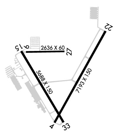
| Rwy | Rwy | |||||||
| 7193x150 | 7193' | 109.75 - 035° | 7193x150 | 7193' | ||||
| 2636x60 | 2636' | 2636x60 | 2636' | |||||
| 6286x150 | 6015' | 6286x150 | 6286' | |||||
| Runway ID | Single Wheel | Double Wheel | Double Tandem Wheel | Dual Double Wheel |
| 04/22 | 45,000 | 95,000 | 150,000 | 420,000 |
| 09/27 | N/A | N/A | N/A | N/A |
| 15/33 | 45,000 | 80,000 | 140,000 | N/A |
| These numbers are Advisory and are not limits. The Airport Manager should have more accurate Weight Limits | ||||
 Airport Diagram might not be current. | |
| Facility Name: | PUNTA GORDA |
| City Name: | PUNTA GORDA |
| County: | CHARLOTTE |
| State abbrev: | FL |
| State Name: | FLORIDA |
| Ownership: | PUBLICLY OWNED |
| Use: | OPEN TO THE PUBLIC |
| Owner's Name: | CHARLOTTE COUNTY ARPT AUTH |
| Address: | 28000 A-1 AIRPORT RD |
| PUNTA GORDA, FL 33982 | |
| Owner's Phone: | 941-639-1101 |
| Manager's Name: | JAMES W PARISH |
| Address: | 28000 A-1 AIRPORT RD |
| PUNTA GORDA, FL 33982 | |
| Phone: | 941-639-1101; 941-639-1101 EXT123. |
| FAA Region: | SOUTHERN |
| FAA Field Office: | ORL |
| Date | Sunrise | Sunset |
|---|---|---|
| 09/24/21 Friday | 7:17 | 19:22 |
| 09/25/21 Saturday | 7:18 | 19:21 |
| 09/26/21 Sunday | 7:18 | 19:20 |
| 09/27/21 Monday | 7:19 | 19:19 |
| 09/28/21 Tuesday | 7:19 | 19:18 |
| 09/29/21 Wednesday | 7:19 | 19:17 |
| 09/30/21 Thursday | 7:20 | 19:16 |
| 10/01/21 Friday | 7:20 | 19:15 |
| 10/02/21 Saturday | 7:21 | 19:13 |
| 10/03/21 Sunday | 7:21 | 19:12 |
| 10/04/21 Monday | 7:22 | 19:11 |
| 10/05/21 Tuesday | 7:22 | 19:10 |
| 10/06/21 Wednesday | 7:23 | 19:09 |
| 10/07/21 Thursday | 7:23 | 19:08 |
| Airport Attendance Schedule | CONTINUOUS |
| Airport Status | OPERATIONAL (This Status can change at any time - please check NOTAMS) |
| Airport Lighting Schedule | ACTVT REIL RWY 04, 15, 22 & 33; PAPI RWY 04, 15, 22 & 33 - CTAF. HIRL RWY 04/22; MIRL RWY 15/33 PRESET ON LOW INTST; TO INCR INTST - CTAF. |
| Airport Storage Available | Tie Downs, Hanger |
| Extra Services Available | Charter, Flight Instruction, Aircraft Rental |
| Wind Indicator | YES - (lighted) |
| Control Tower | YES |
| CTAF Frequency | 121.000 |
| Unicom Frequency | 122.975 |
| Rotating Beacon Color | CLEAR-GREEN (Light Land Airport) |
| Segmented Circle | YES |
| Landing Fee | NO |
| Airport Inspected | FEDERAL - performed by FAA AIRPORTS FIELD PERSONNEL |
| Inspection Date | 01/30/2020 |
| Type of Fuel Available | Grade 100LL, JET A (freeze point -40C), JET A; -10FUEL 24 HR CREDIT CARD SVC AVBL. |
| Airframe Repair Service | MAJOR |
| Power Plant Repair Service | MAJOR |
| Latitude | N2655.1 |
| Longitude | W08159.5 (ESTIMATED) |
| Arpt Elevation | 25ft (SURVEYED) |
| Magnetic Variation | 06W |
| 3 miles SE | of PUNTA GORDA |
| Traffic Pattern Altitude | |
| Sectional Chart | MIAMI |
| Operations (Reported) | Yearly | Avg. Daily |
|---|---|---|
| General Aviation Transient | 40512 | 111 |
| General Aviation Local | 26315 | 72 |
| Air Taxi | 1363 | 4 |
| Commerical | 10424 | 29 |
| Commuter | 0 | 0 |
| Military | 791 | 2 |
| Aircraft based on Field | |
|---|---|
| General Aviation Singles | 312 |
| General Aviation Multi | 43 |
| Jet Aircraft | 20 |
| General Aviation Helicopters | 9 |
| Military Aircraft | 0 |
| Gliders | 1 |
| Ultralights | 0 |
| FSS on field | NO |
| FSS tie-in | SAINT PETERSBURG |
| FSS Phone | 1-800-WX-BRIEF |
| Who issues Notams | PGD |
| Notam D service at airport | YES |
| ARTCC Name | MIAMI |
| Airport Certification | AIRPORT RECEIVING SCHEDULED AIR CARRIER SERVICE FROM CARRIERS CERTIFICATED BY THE CIVIL AERONAUTICS BOARD |
| Aircraft Rescue & Firefighting Index | AIRPORT HAS A CERTIFICATE UNDER CFR PART 139 |
| Airport of Entry | No |
| Custom Landing Rights | No |
| Joint Civil/Military | No |
| Military Landing rights | YES |
| NATIONAL PLAN OF INTEGRATED AIRPORT SYSTEMS (NPIAS) |
| GRANT AGREEMENTS UNDER FAAP/ADAP/AIP |
| SURPLUS PROPERTY AGREEMENT UNDER PUBLIC LAW 289 |
| SURPLUS PROPERTY AGREEMENT UNDER REGULATION 16-WAA |
| ASSURANCES PURSUANT TO TITLE VI, CIVIL RIGHTS ACT OF 1964 |
| AGREEMENT UNDER DLAND OR DCLA HAS EXPIRED. |
| FOR CD IF UNA TO CTC ON FSS FREQ, CTC FT MYERS APCH AT 239-768-1377, WHEN APCH CLSD CTC MIAMI ARTCC AT 305-716-1731. |
| RWY 09/2 7 RSTRD TO ACFT LESS THAN 6000 LBS. NOT AVBL FOR SKED ACR OPS WITH MORE THAN 9 PAX SEATS OR UNSKED ACR AT LEAST 31 PAX SEATS. |
Airport Communications & Frequencies:
| |||||||||||||||||||||||||||
| Runway: 04 | Runway: 22 | ||
| Mag heading: | 35° | Mag heading: | 215° |
| Rwy Slope: | .03% Up | Rwy Slope: | -.03% Down |
| Approach: | ILS/DME | Approach: | |
| Pattern: | Left Traffic | Pattern: | Left Traffic |
| Markings: | PRECISION INSTRUMENT | Markings: | NONPRECISION INSTRUMENT |
| Marking Condition: | GOOD | Marking Condition: | GOOD |
| Arresting Dev: | Arresting Dev: | ||
| Lat & Long: | N2654.6 W08159.5 | Lat. & Long.: | N2655.6 W08158.9 |
| Elev: | 23.2 ft. MSL | Elev: | 25.4 ft. MSL |
| TCH: | 50 ft. AGL | TCH: | 31 ft. AGL |
| Visual Glide Path: | 3.00 degrees | Visual Glide Path: | 3.00 degrees |
| Displaced Threshold: | No | Displaced Threshold: | No |
| Touchdown Zone: | YES | Touchdown Zone: | YES |
| Touchdown Elev.: | 23.5 feet | Touchdown Elev.: | 25.5 feet |
| Visual Glide Slope: | 4-Light PAPI on LEFT side of Runway | Visual Glide Slope: | 4-Light PAPI on LEFT side of Runway |
| RVR Equipment: | RVR Equipment: | ||
| RVV Equipment: | NO | RVV Equipment: | NO |
| Approach Lights: | Approach Lights: | ||
| REIL: | YES | REIL: | YES |
| Centerline Lights: | NO | Centerline Lights: | NO |
| Touchdown lights: | NO | Touchdown lights: | NO |
| Runway Category: | Runway with a Non-precision Approach having visibility minimums greater than 3/4 mile | Runway Category: | Runway with a Non-precision Approach having visibility minimums greater than 3/4 mile |
| Declared Distances: | Declared Distances: | ||
| Obstructions: | Obstructions: | TREES | |
| Marked: | Marked: | NOT Marked/Lighted | |
| Clearance slope: | 50:1 | Clearance slope: | 50:1 |
| Obstruction height: | Obstruction height: | 31 feet AGL | |
| Dist. from runway: | Dist. from runway: | 1770 feet | |
| Centerline offset: | Centerline offset: | 390 feet right of centerline | |
| Comments: | Comments: |
| Runway: 09 | Runway: 27 | ||
| Mag heading: | 95° | Mag heading: | 275° |
| Rwy Slope: | .11% Up | Rwy Slope: | -.11% Down |
| Approach: | Approach: | ||
| Pattern: | Left Traffic | Pattern: | Left Traffic |
| Markings: | BASIC | Markings: | BASIC |
| Marking Condition: | POOR | Marking Condition: | POOR |
| Arresting Dev: | Arresting Dev: | ||
| Lat & Long: | N2655.4 W08159.9 | Lat. & Long.: | N2655.4 W08159.4 |
| Elev: | 19.1 ft. MSL | Elev: | 22.1 ft. MSL |
| TCH: | TCH: | ||
| Visual Glide Path: | Visual Glide Path: | ||
| Displaced Threshold: | No | Displaced Threshold: | No |
| Touchdown Zone: | YES | Touchdown Zone: | YES |
| Touchdown Elev.: | 22.2 feet | Touchdown Elev.: | 22.2 feet |
| Visual Glide Slope: | Visual Glide Slope: | ||
| RVR Equipment: | RVR Equipment: | ||
| RVV Equipment: | NO | RVV Equipment: | NO |
| Approach Lights: | Approach Lights: | ||
| REIL: | NO | REIL: | NO |
| Centerline Lights: | NO | Centerline Lights: | NO |
| Touchdown lights: | NO | Touchdown lights: | NO |
| Runway Category: | Runway with a Visual Approach | Runway Category: | Runway with a Visual Approach |
| Declared Distances: | TORA:2635' TODA:2635' ASDA:2635' LDA:2635' | Declared Distances: | TORA:2635' TODA:2635' ASDA:2635' LDA:2635' |
| Obstructions: | TREES | Obstructions: | |
| Marked: | NOT Marked/Lighted | Marked: | |
| Clearance slope: | 50:1 | Clearance slope: | 50:1 |
| Obstruction height: | 40 feet AGL | Obstruction height: | |
| Dist. from runway: | 2210 feet | Dist. from runway: | |
| Centerline offset: | 250 left of centerline | Centerline offset: | |
| Comments: | Comments: |
| Runway: 15 | Runway: 33 | ||
| Mag heading: | 155° | Mag heading: | 335° |
| Rwy Slope: | .07% Up | Rwy Slope: | -.07% Down |
| Approach: | Approach: | ||
| Pattern: | Left Traffic | Pattern: | Left Traffic |
| Markings: | NONPRECISION INSTRUMENT | Markings: | NONPRECISION INSTRUMENT |
| Marking Condition: | GOOD | Marking Condition: | GOOD |
| Arresting Dev: | Arresting Dev: | ||
| Lat & Long: | N2655.4 W08200.0 | Lat. & Long.: | N2654.5 W08159.4 |
| Elev: | 18.5 ft. MSL | Elev: | 23.0 ft. MSL |
| TCH: | 47 ft. AGL | TCH: | 48 ft. AGL |
| Visual Glide Path: | 3.00 degrees | Visual Glide Path: | 3.00 degrees |
| Displaced Threshold: | 271 feet | Displaced Threshold: | No |
| Touchdown Zone: | YES | Touchdown Zone: | YES |
| Touchdown Elev.: | 21.6 feet | Touchdown Elev.: | 23.5 feet |
| Visual Glide Slope: | 4-Light PAPI on LEFT side of Runway | Visual Glide Slope: | 4-Light PAPI on LEFT side of Runway |
| RVR Equipment: | RVR Equipment: | ||
| RVV Equipment: | NO | RVV Equipment: | NO |
| Approach Lights: | Approach Lights: | ||
| REIL: | YES | REIL: | YES |
| Centerline Lights: | NO | Centerline Lights: | NO |
| Touchdown lights: | NO | Touchdown lights: | NO |
| Runway Category: | Runway with a Non-precision Approach having visibility minimums greater than 3/4 mile | Runway Category: | Runway with a Non-precision Approach having visibility minimums greater than 3/4 mile |
| Declared Distances: | TORA:6286' TODA:6286' ASDA:6286' LDA:6015' | Declared Distances: | TORA:6166' TODA:6166' ASDA:6015' LDA:6015' |
| Obstructions: | ROAD | Obstructions: | TREES |
| Marked: | NOT Marked/Lighted | Marked: | NOT Marked/Lighted |
| Clearance slope: | 17:1; RWY 15 APCH SLP 48:1 TO DTHR. | Clearance slope: | 40:1 |
| Obstruction height: | 15 feet AGL | Obstruction height: | 54 feet AGL |
| Dist. from runway: | 460 feet | Dist. from runway: | 2375 feet |
| Centerline offset: | 500 right of centerline | Centerline offset: | 60 feet right of centerline |
| Comments: | Comments: |
Thanks for using FltPlan.com
all rights reserved © 1999-2021 by Flight Plan LLC