
| RYAN FIELD TUCSON AZ |
| |
| Lat: N 3208.5 Long: W 11110.5 Elev: 2419 Var: -12 Longest Runway: 5500 | ||
| AWOS: 133.35 Ground: 118.2 Tower: 125.8 | ||
| ||||||||||||||||||||||||||||||||||||||||||||
| ||||||||||||||||||||||||||||||||||||||||||||
| ||||||||||||||||||||||||||||||||||||||||||||
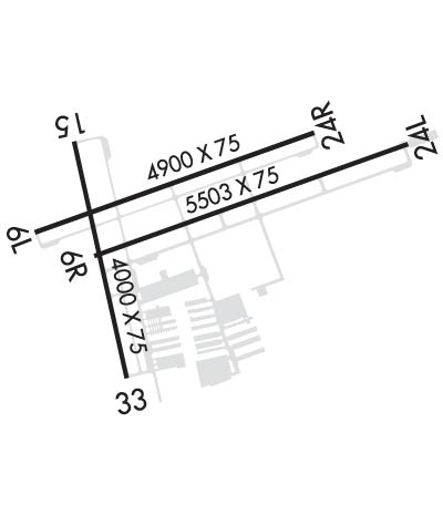
| Rwy | Rwy | |||||||
| 4900x75 | 4900' | 4900x75 | 4900' | |||||
| 5500x75 | 5500' | 111.10 - 058° | 5500x75 | 5500' | ||||
| 4010x75 | 4010' | 4010x75 | 4010' | |||||
| Runway ID | Single Wheel | Double Wheel | Double Tandem Wheel | Dual Double Wheel |
| 06L/24R | 12,500 | 30,000 | N/A | N/A |
| 06R/24L | 12,500 | 30,000 | N/A | N/A |
| 15/33 | N/A | N/A | N/A | N/A |
| These numbers are Advisory and are not limits. The Airport Manager should have more accurate Weight Limits | ||||
 Airport Diagram might not be current. | |
| Facility Name: | RYAN FLD |
| City Name: | TUCSON |
| County: | PIMA |
| State abbrev: | AZ |
| State Name: | ARIZONA |
| Ownership: | PUBLICLY OWNED |
| Use: | OPEN TO THE PUBLIC |
| Owner's Name: | CITY OF TUCSON ARPT AUTH |
| Address: | 7250 S. TUCSON BLVD. SUITE 300 |
| TUCSON, AZ 85756 | |
| Owner's Phone: | 520-573-8100 |
| Manager's Name: | DANETTE BEWLEY |
| Address: | 7250 S. TUCSON BLVD, SUITE 300 |
| TUCSON, AZ 85756 | |
| Phone: | (520) 573-8100; ARPT OPS CONTACT CHRIS BOSTWICK 520-573-8179. CBOSTWICK@FLYTUCSON.COM. |
| FAA Region: | WESTERN-PACIFIC |
| FAA Field Office: | PHX |
| Date | Sunrise | Sunset |
|---|---|---|
| 09/24/21 Friday | 6:14 | 18:19 |
| 09/25/21 Saturday | 6:15 | 18:18 |
| 09/26/21 Sunday | 6:15 | 18:16 |
| 09/27/21 Monday | 6:16 | 18:15 |
| 09/28/21 Tuesday | 6:17 | 18:14 |
| 09/29/21 Wednesday | 6:17 | 18:12 |
| 09/30/21 Thursday | 6:18 | 18:11 |
| 10/01/21 Friday | 6:19 | 18:10 |
| 10/02/21 Saturday | 6:19 | 18:08 |
| 10/03/21 Sunday | 6:20 | 18:07 |
| 10/04/21 Monday | 6:21 | 18:06 |
| 10/05/21 Tuesday | 6:21 | 18:05 |
| 10/06/21 Wednesday | 6:22 | 18:03 |
| 10/07/21 Thursday | 6:23 | 18:02 |
| Airport Attendance Schedule | M-F 0800-1700, SAT 0800-1700 |
| Airport Status | OPERATIONAL (This Status can change at any time - please check NOTAMS) |
| Airport Lighting Schedule | WHEN ATCT CLSD ACTVT MIRL RWY 06R/24L & 15/33 - CTAF. |
| Airport Storage Available | Tie Downs |
| Extra Services Available | Flight Instruction, Aircraft Rental |
| Wind Indicator | YES - (lighted) |
| Control Tower | YES |
| CTAF Frequency | 125.800 |
| Unicom Frequency | |
| Rotating Beacon Color | CLEAR-GREEN (Light Land Airport) |
| Segmented Circle | YES |
| Landing Fee | NO |
| Airport Inspected | STATE - performed by PRIVATE CONTRACT PERSONNEL |
| Inspection Date | 03/30/2020 |
| Type of Fuel Available | Grade 100LL, JET A (freeze point -40C); -10FUEL IS AVBL FM 0800 TO 1700. AFTER HOURS, JET A AVBL AS AN ON-CALL SERVICE, AND A $100 FEE APPLIES. PRIOR ARRANGEMENTS CAN BE MADE BY CALLING 520-744-7474; SELF SERVE 100LL AVBL 24 HRS WITH MAJOR CREDIT CARD. |
| Airframe Repair Service | MAJOR |
| Power Plant Repair Service | MAJOR |
| Latitude | N3208.5 |
| Longitude | W11110.5 (ESTIMATED) |
| Arpt Elevation | 2418ft (SURVEYED) |
| Magnetic Variation | 12E |
| 10 miles SW | of TUCSON |
| Traffic Pattern Altitude | 800 |
| Sectional Chart | PHOENIX |
| Operations (Reported) | Yearly | Avg. Daily |
|---|---|---|
| General Aviation Transient | 40171 | 110 |
| General Aviation Local | 56508 | 155 |
| Air Taxi | 0 | 0 |
| Commerical | 0 | 0 |
| Commuter | 0 | 0 |
| Military | 13349 | 37 |
| Aircraft based on Field | |
|---|---|
| General Aviation Singles | 207 |
| General Aviation Multi | 17 |
| Jet Aircraft | 1 |
| General Aviation Helicopters | 0 |
| Military Aircraft | 0 |
| Gliders | 0 |
| Ultralights | 1 |
| FSS on field | NO |
| FSS tie-in | PRESCOTT |
| FSS Phone | 1-800-WX-BRIEF |
| Who issues Notams | PRC |
| Notam D service at airport | YES |
| ARTCC Name | ALBUQUERQUE |
| Airport Certification | |
| Aircraft Rescue & Firefighting Index | None |
| Airport of Entry | No |
| Custom Landing Rights | No |
| Joint Civil/Military | No |
| Military Landing rights | YES |
| NATIONAL PLAN OF INTEGRATED AIRPORT SYSTEMS (NPIAS) |
| GRANT AGREEMENTS UNDER FAAP/ADAP/AIP |
| SURPLUS PROPERTY AGREEMENT UNDER PUBLIC LAW 289 |
| ASSURANCES PURSUANT TO TITLE VI, CIVIL RIGHTS ACT OF 1964 |
| RWY 06R AND 06L PREFERENTIAL RWY UP TO 10 KNOT TAILWIND. |
| USE LANDING LIGHTS IN PATTERN. |
| FREQUENT PRACTICE ILS APPROACHES TO RWY 06R. |
| AFTERNOON WINDS USUALLY FAVOR RWY 24L AND 24R. |
| FOR CD WHEN ATCT IS CLSD CTC TUCSON APCH AT 520-829-6121. |
Airport Communications & Frequencies:
| |||||||||||||||||||||||
| Runway: 06L | Runway: 24R | ||
| Mag heading: | 58° | Mag heading: | 238° |
| Rwy Slope: | .07% Up | Rwy Slope: | -.07% Down |
| Approach: | Approach: | ||
| Pattern: | Left Traffic | Pattern: | Right Traffic |
| Markings: | BASIC | Markings: | BASIC |
| Marking Condition: | FAIR | Marking Condition: | FAIR |
| Arresting Dev: | Arresting Dev: | ||
| Lat & Long: | N3208.5 W11110.9 | Lat. & Long.: | N3208.7 W11110.1 |
| Elev: | 2393.1 ft. MSL | Elev: | 2396.4 ft. MSL |
| TCH: | TCH: | ||
| Visual Glide Path: | Visual Glide Path: | ||
| Displaced Threshold: | No | Displaced Threshold: | No |
| Touchdown Zone: | YES | Touchdown Zone: | YES |
| Touchdown Elev.: | 2396.8 feet | Touchdown Elev.: | 2396.8 feet |
| Visual Glide Slope: | Visual Glide Slope: | ||
| RVR Equipment: | RVR Equipment: | ||
| RVV Equipment: | NO | RVV Equipment: | NO |
| Approach Lights: | Approach Lights: | ||
| REIL: | YES | REIL: | NO |
| Centerline Lights: | NO | Centerline Lights: | NO |
| Touchdown lights: | NO | Touchdown lights: | NO |
| Runway Category: | Runway with a Visual Approach | Runway Category: | Runway with a Visual Approach |
| Declared Distances: | Declared Distances: |
| Runway: 06R | Runway: 24L | ||
| Mag heading: | 58° | Mag heading: | 238° |
| Rwy Slope: | .08% Up | Rwy Slope: | -.08% Down |
| Approach: | ILS/DME | Approach: | |
| Pattern: | Right Traffic | Pattern: | Left Traffic |
| Markings: | PRECISION INSTRUMENT | Markings: | BASIC |
| Marking Condition: | GOOD | Marking Condition: | GOOD |
| Arresting Dev: | Arresting Dev: | ||
| Lat & Long: | N3208.4 W11110.8 | Lat. & Long.: | N3208.7 W11109.8 |
| Elev: | 2398.7 ft. MSL | Elev: | 2403.0 ft. MSL |
| TCH: | TCH: | 26 ft. AGL | |
| Visual Glide Path: | Visual Glide Path: | 3.00 degrees | |
| Displaced Threshold: | No | Displaced Threshold: | No |
| Touchdown Zone: | YES | Touchdown Zone: | YES |
| Touchdown Elev.: | 2402.4 feet | Touchdown Elev.: | 2403.1 feet |
| Visual Glide Slope: | Visual Glide Slope: | 4-BOX VASI ON LEFT SIDE OF RUNWAY | |
| RVR Equipment: | RVR Equipment: | ||
| RVV Equipment: | NO | RVV Equipment: | NO |
| Approach Lights: | Approach Lights: | ||
| REIL: | YES; REIL RY 06R OPER DAYLIGHT HRS ONLY. | REIL: | NO |
| Centerline Lights: | NO | Centerline Lights: | NO |
| Touchdown lights: | NO | Touchdown lights: | NO |
| Runway Category: | Precision Instrument Runway | Runway Category: | Runway with a Visual Approach |
| Declared Distances: | Declared Distances: |
| Runway: 15 | Runway: 33 | ||
| Mag heading: | 155° | Mag heading: | 335° |
| Rwy Slope: | .80% Up | Rwy Slope: | -.80% Down |
| Approach: | Approach: | ||
| Pattern: | Right Traffic | Pattern: | Left Traffic |
| Markings: | BASIC | Markings: | BASIC |
| Marking Condition: | GOOD | Marking Condition: | GOOD |
| Arresting Dev: | Arresting Dev: | ||
| Lat & Long: | N3208.7 W11110.8 | Lat. & Long.: | N3208.1 W11110.7 |
| Elev: | 2386.7 ft. MSL | Elev: | 2418.8 ft. MSL |
| TCH: | TCH: | ||
| Visual Glide Path: | Visual Glide Path: | ||
| Displaced Threshold: | No | Displaced Threshold: | No |
| Touchdown Zone: | YES | Touchdown Zone: | YES |
| Touchdown Elev.: | 2412.6 feet | Touchdown Elev.: | 2418.9 feet |
| Visual Glide Slope: | Visual Glide Slope: | ||
| RVR Equipment: | RVR Equipment: | ||
| RVV Equipment: | NO | RVV Equipment: | NO |
| Approach Lights: | Approach Lights: | ||
| REIL: | NO | REIL: | NO |
| Centerline Lights: | NO | Centerline Lights: | NO |
| Touchdown lights: | NO | Touchdown lights: | NO |
| Runway Category: | Runway with a Visual Approach | Runway Category: | Runway with a Visual Approach |
| Declared Distances: | Declared Distances: |
Thanks for using FltPlan.com
all rights reserved © 1999-2021 by Flight Plan LLC
