
| AVENGER FIELD SWEETWATER TX |
| |
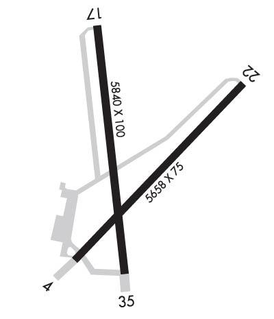
| Lat: N 3228.0 Long: W 10028.0 Elev: 2380 Var: -08 Longest Runway: 5840 | ||
| AWOS: 119.02 CTAF: 122.8 | ||
| ||||||||||||||||||||||||||||||||||||||||||||
| ||||||||||||||||||||||||||||||||||||||||||||
| ||||||||||||||||||||||||||||||||||||||||||||
| Rwy | Rwy | |||||||
| 5658x75 | 5658' | 5658x75 | 5658' | |||||
| 5840x100 | 5840' | 5840x100 | 5840' | |||||
| Runway ID | Single Wheel | Double Wheel | Double Tandem Wheel | Dual Double Wheel |
| 04/22 | 30,000 | N/A | N/A | N/A |
| 17/35 | 30,000 | N/A | N/A | N/A |
| These numbers are Advisory and are not limits. The Airport Manager should have more accurate Weight Limits | ||||
 Airport Diagram might not be current. | |
| Facility Name: | AVENGER FLD |
| City Name: | SWEETWATER |
| County: | NOLAN |
| State abbrev: | TX |
| State Name: | TEXAS |
| Ownership: | PUBLICLY OWNED |
| Use: | OPEN TO THE PUBLIC |
| Owner's Name: | CITY OF SWEETWATER |
| Address: | PO BOX 450 |
| SWEETWATER, TX 79556 | |
| Owner's Phone: | 325-236-6313 |
| Manager's Name: | BOB ELLIOTT; DIR. PLANNING & DELVELOPMENT SERV/AMGR. |
| Address: | P.O. BOX 450 |
| SWEETWATER, TX 79556 | |
| Phone: | 325-235-8478; FOR ARPT ATNDT/FBO 325-235-4878. PIPELINEBOB@GMAIL.COM. |
| FAA Region: | SOUTHWEST |
| FAA Field Office: | TEX |
| Date | Sunrise | Sunset |
|---|---|---|
| 09/24/21 Friday | 7:31 | 19:36 |
| 09/25/21 Saturday | 7:32 | 19:35 |
| 09/26/21 Sunday | 7:32 | 19:33 |
| 09/27/21 Monday | 7:33 | 19:32 |
| 09/28/21 Tuesday | 7:34 | 19:31 |
| 09/29/21 Wednesday | 7:34 | 19:29 |
| 09/30/21 Thursday | 7:35 | 19:28 |
| 10/01/21 Friday | 7:36 | 19:27 |
| 10/02/21 Saturday | 7:36 | 19:26 |
| 10/03/21 Sunday | 7:37 | 19:24 |
| 10/04/21 Monday | 7:38 | 19:23 |
| 10/05/21 Tuesday | 7:38 | 19:22 |
| 10/06/21 Wednesday | 7:39 | 19:20 |
| 10/07/21 Thursday | 7:40 | 19:19 |
| Airport Attendance Schedule | 7 Days A Week 0800-1800; HOLIDAYS INTMT |
| Airport Status | OPERATIONAL (This Status can change at any time - please check NOTAMS) |
| Airport Lighting Schedule | SS-SR |
| Airport Storage Available | Tie Downs, Hanger |
| Extra Services Available | Flight Instruction, Aircraft Rental |
| Wind Indicator | YES - (lighted) |
| Control Tower | NO |
| CTAF Frequency | 122.800 |
| Unicom Frequency | 122.800 |
| Rotating Beacon Color | CLEAR-GREEN (Light Land Airport) |
| Segmented Circle | YES |
| Landing Fee | NO |
| Airport Inspected | STATE - performed by PRIVATE CONTRACT PERSONNEL |
| Inspection Date | 05/23/2021 |
| Type of Fuel Available | Grade 100LL, JET A-1 (icing inhibitor, freeze point -50C); -10FOR FUEL AFT HRS CALL 325-235-8478. |
| Airframe Repair Service | NONE |
| Power Plant Repair Service | NONE |
| Latitude | N3228.0 |
| Longitude | W10028.0 (ESTIMATED) |
| Arpt Elevation | 2379ft (SURVEYED) |
| Magnetic Variation | 08E |
| 3 miles W | of SWEETWATER |
| Traffic Pattern Altitude | |
| Sectional Chart | DALLAS-FT WORTH |
| Operations (Reported) | Yearly | Avg. Daily |
|---|---|---|
| General Aviation Transient | 1300 | 4 |
| General Aviation Local | 2600 | 7 |
| Air Taxi | 0 | 0 |
| Commerical | 0 | 0 |
| Commuter | 0 | 0 |
| Military | 0 | 0 |
| Aircraft based on Field | |
|---|---|
| General Aviation Singles | 14 |
| General Aviation Multi | 1 |
| Jet Aircraft | 0 |
| General Aviation Helicopters | 1 |
| Military Aircraft | 0 |
| Gliders | 0 |
| Ultralights | 0 |
| FSS on field | NO |
| FSS tie-in | FORT WORTH |
| FSS Phone | 1-800-WX-BRIEF |
| Who issues Notams | SWW |
| Notam D service at airport | YES |
| ARTCC Name | FORT WORTH |
| Airport Certification | |
| Aircraft Rescue & Firefighting Index | None |
| Airport of Entry | No |
| Custom Landing Rights | No |
| Joint Civil/Military | No |
| Military Landing rights | YES |
| NATIONAL PLAN OF INTEGRATED AIRPORT SYSTEMS (NPIAS) |
| GRANT AGREEMENTS UNDER FAAP/ADAP/AIP |
| SURPLUS PROPERTY AGREEMENT UNDER REGULATION 16-WAA |
| ASSURANCES PURSUANT TO TITLE VI, CIVIL RIGHTS ACT OF 1964 |
| AGREEMENT UNDER DLAND OR DCLA HAS EXPIRED. |
| FOR CD CTC FORT WORTH ARTCC AT 817-858-7584. |
Airport Communications & Frequencies:
| ||||||||||||||
| Runway: 04 | Runway: 22 | ||
| Mag heading: | 35° | Mag heading: | 215° |
| Rwy Slope: | -.75% Down | Rwy Slope: | .75% Up |
| Approach: | Approach: | ||
| Pattern: | Left Traffic | Pattern: | Left Traffic |
| Markings: | NONPRECISION INSTRUMENT | Markings: | NONPRECISION INSTRUMENT |
| Marking Condition: | GOOD | Marking Condition: | GOOD |
| Arresting Dev: | Arresting Dev: | ||
| Lat & Long: | N3227.7 W10028.3 | Lat. & Long.: | N3228.3 W10027.5 |
| Elev: | 2379.5 ft. MSL | Elev: | 2336.9 ft. MSL |
| TCH: | 40 ft. AGL | TCH: | 40 ft. AGL |
| Visual Glide Path: | 3.00 degrees | Visual Glide Path: | 3.00 degrees |
| Displaced Threshold: | No | Displaced Threshold: | No |
| Touchdown Zone: | YES | Touchdown Zone: | YES |
| Touchdown Elev.: | 2379.7 feet | Touchdown Elev.: | 2354.5 feet |
| Visual Glide Slope: | 2-Light PAPI on LEFT side of Runway | Visual Glide Slope: | 2-Light PAPI on LEFT side of Runway |
| RVR Equipment: | RVR Equipment: | ||
| RVV Equipment: | NO | RVV Equipment: | NO |
| Approach Lights: | Approach Lights: | ||
| REIL: | NO | REIL: | NO |
| Centerline Lights: | NO | Centerline Lights: | NO |
| Touchdown lights: | NO | Touchdown lights: | NO |
| Runway Category: | Runway with a Non-precision Approach having visibility minimums greater than 3/4 mile | Runway Category: | Runway with a Non-precision Approach having visibility minimums greater than 3/4 mile |
| Declared Distances: | Declared Distances: | ||
| Obstructions: | TREES | Obstructions: | POLE |
| Marked: | NOT Marked/Lighted | Marked: | NOT Marked/Lighted |
| Clearance slope: | 23:1 | Clearance slope: | 10:1 |
| Obstruction height: | 37 feet AGL | Obstruction height: | 35 feet AGL |
| Dist. from runway: | 1060 feet | Dist. from runway: | 555 feet |
| Centerline offset: | 300 right of centerline | Centerline offset: | 245 feet right of centerline |
| Comments: | Comments: | +15 FT GRVL ROAD 199 FT FM THR, 236 FT L OF CNTRLN. |
| Runway: 17 | Runway: 35 | ||
| Mag heading: | 166° | Mag heading: | 346° |
| Rwy Slope: | .48% Up | Rwy Slope: | -.48% Down |
| Approach: | Approach: | ||
| Pattern: | Left Traffic | Pattern: | Left Traffic |
| Markings: | NONPRECISION INSTRUMENT | Markings: | NONPRECISION INSTRUMENT |
| Marking Condition: | GOOD | Marking Condition: | GOOD |
| Arresting Dev: | Arresting Dev: | ||
| Lat & Long: | N3228.6 W10028.2 | Lat. & Long.: | N3227.6 W10028.0 |
| Elev: | 2340.7 ft. MSL | Elev: | 2369.0 ft. MSL |
| TCH: | 40 ft. AGL | TCH: | 40 ft. AGL |
| Visual Glide Path: | 3.00 degrees | Visual Glide Path: | 3.00 degrees |
| Displaced Threshold: | No | Displaced Threshold: | No |
| Touchdown Zone: | YES | Touchdown Zone: | YES |
| Touchdown Elev.: | 2363.8 feet | Touchdown Elev.: | 2369.3 feet |
| Visual Glide Slope: | 4-Light PAPI on LEFT side of Runway | Visual Glide Slope: | 4-Light PAPI on LEFT side of Runway |
| RVR Equipment: | RVR Equipment: | ||
| RVV Equipment: | NO | RVV Equipment: | NO |
| Approach Lights: | Approach Lights: | ||
| REIL: | YES | REIL: | YES |
| Centerline Lights: | NO | Centerline Lights: | NO |
| Touchdown lights: | NO | Touchdown lights: | NO |
| Runway Category: | Runway with a Non-precision Approach having visibility minimums greater than 3/4 mile | Runway Category: | Runway with a Non-precision Approach having visibility minimums greater than 3/4 mile |
| Declared Distances: | Declared Distances: | ||
| Obstructions: | TREES | Obstructions: | POLE |
| Marked: | NOT Marked/Lighted | Marked: | NOT Marked/Lighted |
| Clearance slope: | 15:1 | Clearance slope: | 16:1 |
| Obstruction height: | 12 feet AGL | Obstruction height: | 37 feet AGL |
| Dist. from runway: | 388 feet | Dist. from runway: | 820 feet |
| Centerline offset: | 270 right of centerline | Centerline offset: | 325 feet right of centerline |
| Comments: | Comments: |
Thanks for using FltPlan.com
all rights reserved © 1999-2021 by Flight Plan LLC
