
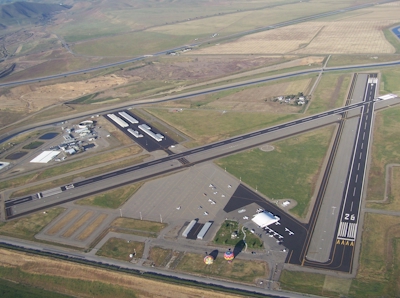
| TRACY MUNI TRACY CA |
| |
| Lat: N 3741.3 Long: W 12126.5 Elev: 194 Var: -15 Longest Runway: 4001 | ||
| AWOS: 118.37 CTAF: 123.07 | ||
| ||||||||||||||||||||||||||||||||||||||||||||
| ||||||||||||||||||||||||||||||||||||||||||||
| ||||||||||||||||||||||||||||||||||||||||||||
| Rwy | Rwy | |||||||
| 3438x75 | 3438' | 3438x75 | 3438' | |||||
| 4001x75 | 4001' | 4001x75 | 3740' | |||||
| Runway ID | Single Wheel | Double Wheel | Double Tandem Wheel | Dual Double Wheel |
| 08/26 | 50,000 | 70,000 | 120,000 | N/A |
| 12/30 | 50,000 | 70,000 | 120,000 | N/A |
| These numbers are Advisory and are not limits. The Airport Manager should have more accurate Weight Limits | ||||
 Airport Diagram might not be current. | |
| Facility Name: | TRACY MUNI |
| City Name: | TRACY |
| County: | SAN JOAQUIN |
| State abbrev: | CA |
| State Name: | CALIFORNIA |
| Ownership: | PUBLICLY OWNED |
| Use: | OPEN TO THE PUBLIC |
| Owner's Name: | CITY OF TRACY |
| Address: | 333 CIVIC CENTER PLAZA |
| TRACY, CA 95376-4917 | |
| Owner's Phone: | (209) 831-6200 |
| Manager's Name: | PAULA JESSUP |
| Address: | 5749 SOUTH TRACY BLVD |
| TRACY, CA 95376-4917 | |
| Phone: | (209) 831-6215 |
| FAA Region: | WESTERN-PACIFIC |
| FAA Field Office: | SFO |
| Date | Sunrise | Sunset |
|---|---|---|
| 04/08/25 Tuesday | 6:41 | 19:35 |
| 04/09/25 Wednesday | 6:40 | 19:36 |
| 04/10/25 Thursday | 6:38 | 19:37 |
| 04/11/25 Friday | 6:37 | 19:38 |
| 04/12/25 Saturday | 6:35 | 19:39 |
| 04/13/25 Sunday | 6:34 | 19:39 |
| 04/14/25 Monday | 6:32 | 19:40 |
| 04/15/25 Tuesday | 6:31 | 19:41 |
| 04/16/25 Wednesday | 6:30 | 19:42 |
| 04/17/25 Thursday | 6:28 | 19:43 |
| 04/18/25 Friday | 6:27 | 19:44 |
| 04/19/25 Saturday | 6:25 | 19:45 |
| 04/20/25 Sunday | 6:24 | 19:46 |
| 04/21/25 Monday | 6:23 | 19:47 |
| Airport Attendance Schedule | 7 Days A Week 0800-1800 |
| Airport Status | OPERATIONAL (This Status can change at any time - please check NOTAMS) |
| Airport Lighting Schedule | ACTVT REIL RWY 08, 26, 12, & 30; PAPI RWY 08, 12 & 26; MIRL RWY 08/26 & 12/30 - CTAF. PAPI RWY 30 IS OPRD AT NGT BY CTAF FROM SS TO SR AND IS ON DRG DALGT HRS. |
| Airport Storage Available | Tie Downs |
| Extra Services Available | Flight Instruction, Aircraft Rental |
| Wind Indicator | YES - (lighted) |
| Control Tower | NO |
| CTAF Frequency | 123.075 |
| Unicom Frequency | 123.075 |
| Rotating Beacon Color | WG |
| Segmented Circle | YES |
| Landing Fee | NO |
| Airport Inspected | STATE - performed by STATE AERONAUTICAL PERSONNEL |
| Inspection Date | 12/03/2024 |
| Type of Fuel Available | Grade 100LL, JET A (freeze point -40C) |
| Airframe Repair Service | MAJOR |
| Power Plant Repair Service | MAJOR |
| Latitude | N3741.3 |
| Longitude | W12126.5 (ESTIMATED) |
| Arpt Elevation | 193ft (SURVEYED) |
| Magnetic Variation | 15E |
| 3 miles SW | of TRACY |
| Traffic Pattern Altitude | 800 |
| Sectional Chart | SAN FRANCISCO |
| Operations (Reported) | Yearly | Avg. Daily |
|---|---|---|
| General Aviation Transient | 0 | 0 |
| General Aviation Local | 0 | 0 |
| Air Taxi | 0 | 0 |
| Commerical | 0 | 0 |
| Commuter | 0 | 0 |
| Military | 0 | 0 |
| Aircraft based on Field | |
|---|---|
| General Aviation Singles | 0 |
| General Aviation Multi | 0 |
| Jet Aircraft | 0 |
| General Aviation Helicopters | 0 |
| Military Aircraft | 0 |
| Gliders | 0 |
| Ultralights | 0 |
| FSS on field | NO |
| FSS tie-in | RANCHO MURIETA |
| FSS Phone | 1-800-WX-BRIEF |
| Who issues Notams | TCY |
| Notam D service at airport | YES |
| ARTCC Name | OAKLAND |
| Airport Certification | |
| Aircraft Rescue & Firefighting Index | None |
| Airport of Entry | No |
| Custom Landing Rights | No |
| Joint Civil/Military | No |
| Military Landing rights | YES |
| NATIONAL PLAN OF INTEGRATED AIRPORT SYSTEMS (NPIAS) |
| GRANT AGREEMENTS UNDER FAAP/ADAP/AIP |
| SURPLUS PROPERTY AGREEMENT UNDER REGULATION 16-WAA |
| ASSURANCES PURSUANT TO TITLE VI, CIVIL RIGHTS ACT OF 1964 |
| BALLOON AND PARAPLANE ACTIVITY ON THE AIRPORT. |
| AEROBATIC AREA ADJ/WI 1 SMR FROM 500 AGL - 3000 MSL SR-SS. |
| TWO 150 FT PWR PLANT STACKS APPROX 3 NM NW OF ARPT. WATCH FOR PSBL TURB. |
| FOR CD CTC NORCAL APCH AT 916-361-0516. |
Airport Communications & Frequencies:
| ||||||||||||||
| Runway: 08 | Runway: 26 | ||
| Mag heading: | 75° | Mag heading: | 255° |
| Rwy Slope: | -.51% Down | Rwy Slope: | .51% Up |
| Approach: | Approach: | ||
| Pattern: | Left Traffic | Pattern: | Left Traffic |
| Markings: | NONPRECISION INSTRUMENT | Markings: | NONPRECISION INSTRUMENT |
| Marking Condition: | GOOD | Marking Condition: | GOOD |
| Arresting Dev: | Arresting Dev: | ||
| Lat & Long: | N3741.4 W12126.9 | Lat. & Long.: | N3741.4 W12126.2 |
| Elev: | 190.3 ft. MSL | Elev: | 172.7 ft. MSL |
| TCH: | 26 ft. AGL | TCH: | 20 ft. AGL |
| Visual Glide Path: | 3.40 degrees | Visual Glide Path: | 3.00 degrees |
| Displaced Threshold: | No | Displaced Threshold: | No |
| Touchdown Zone: | YES | Touchdown Zone: | YES |
| Touchdown Elev.: | 190.3 feet | Touchdown Elev.: | 186.0 feet |
| Visual Glide Slope: | 2-Light PAPI on LEFT side of Runway | Visual Glide Slope: | 2-Light PAPI on LEFT side of Runway |
| RVR Equipment: | RVR Equipment: | ||
| RVV Equipment: | NO | RVV Equipment: | NO |
| Approach Lights: | Approach Lights: | ||
| REIL: | YES | REIL: | YES |
| Centerline Lights: | NO | Centerline Lights: | NO |
| Touchdown lights: | NO | Touchdown lights: | NO |
| Runway Category: | Runway with a Visual Approach | Runway Category: | Runway with a Non-precision Approach |
| Declared Distances: | Declared Distances: | ||
| Obstructions: | FENCE | Obstructions: | ROAD |
| Marked: | NOT Marked/Lighted | Marked: | NOT Marked/Lighted |
| Clearance slope: | 18:1 | Clearance slope: | 20:1 |
| Obstruction height: | 8 feet AGL | Obstruction height: | 15 feet AGL |
| Dist. from runway: | 350 feet | Dist. from runway: | 500 feet |
| Centerline offset: | 140 right of centerline | Centerline offset: | |
| Comments: | Comments: |
| Runway: 12 | Runway: 30 | ||
| Mag heading: | 117° | Mag heading: | 297° |
| Rwy Slope: | .32% Up | Rwy Slope: | -.32% Down |
| Approach: | Approach: | ||
| Pattern: | Left Traffic | Pattern: | Left Traffic |
| Markings: | NONPRECISION INSTRUMENT | Markings: | NONPRECISION INSTRUMENT |
| Marking Condition: | GOOD | Marking Condition: | GOOD |
| Arresting Dev: | Arresting Dev: | ||
| Lat & Long: | N3741.5 W12126.8 | Lat. & Long.: | N3741.0 W12126.1 |
| Elev: | 180.9 ft. MSL | Elev: | 193.6 ft. MSL |
| TCH: | 41 ft. AGL | TCH: | 35 ft. AGL |
| Visual Glide Path: | 3.00 degrees | Visual Glide Path: | 3.00 degrees |
| Displaced Threshold: | No | Displaced Threshold: | 261 feet |
| Touchdown Zone: | YES | Touchdown Zone: | YES |
| Touchdown Elev.: | 193.4 feet | Touchdown Elev.: | 193.6 feet |
| Visual Glide Slope: | 2-Light PAPI on LEFT side of Runway; UNUSBL BYD 5 DEGS LEFT OF CNTRLN. | Visual Glide Slope: | 2-Light PAPI on LEFT side of Runway |
| RVR Equipment: | RVR Equipment: | ||
| RVV Equipment: | NO | RVV Equipment: | NO |
| Approach Lights: | Approach Lights: | ||
| REIL: | YES | REIL: | YES |
| Centerline Lights: | NO | Centerline Lights: | NO |
| Touchdown lights: | NO | Touchdown lights: | NO |
| Runway Category: | Runway with a Non-precision Approach | Runway Category: | Runway with a Non-precision Approach |
| Declared Distances: | Declared Distances: | ||
| Obstructions: | BLDG | Obstructions: | ROAD |
| Marked: | NOT Marked/Lighted | Marked: | NOT Marked/Lighted |
| Clearance slope: | 36:1 | Clearance slope: | 20:1 |
| Obstruction height: | 25 feet AGL | Obstruction height: | 15 feet AGL |
| Dist. from runway: | 1100 feet | Dist. from runway: | 510 feet |
| Centerline offset: | Centerline offset: | 280 feet right of centerline | |
| Comments: | Comments: |
Thanks for using FltPlan.com
all rights reserved © 1999-2025 by Flight Plan LLC