
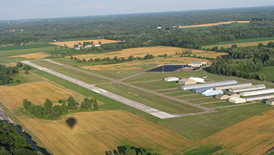
| MASON JEWETT FIELD MASON MI |
| |
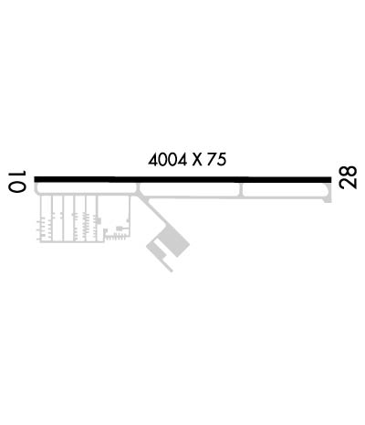
| Lat: N 4233.9 Long: W 08425.4 Elev: 919 Var: +05 Longest Runway: 4002 | ||
| AWOS: 119.42 CTAF: 122.7 | ||
| ||||||||||||||||||||||||||||||||||||||||||||
| ||||||||||||||||||||||||||||||||||||||||||||
| ||||||||||||||||||||||||||||||||||||||||||||
| Rwy | Rwy | |||||||
| 4002x75 | 4002' | 4002x75 | 4002' | |||||
| Runway ID | Single Wheel | Double Wheel | Double Tandem Wheel | Dual Double Wheel |
| 10/28 | 12,500 | N/A | N/A | N/A |
| These numbers are Advisory and are not limits. The Airport Manager should have more accurate Weight Limits | ||||
 Airport Diagram might not be current. | |
| Facility Name: | MASON JEWETT FLD |
| City Name: | MASON |
| County: | INGHAM |
| State abbrev: | MI |
| State Name: | MICHIGAN |
| Ownership: | PUBLICLY OWNED |
| Use: | OPEN TO THE PUBLIC |
| Owner's Name: | CAPITAL REGION AIRPORT AUTHORITY |
| Address: | 4100 CAPITOL CITY BLVD |
| LANSING, MI 48906-2183 | |
| Owner's Phone: | 517-321-6121 |
| Manager's Name: | ROBERT BENSTEIN |
| Address: | CAPITAL REGION ARPT AUTHORITY, 4100 CAPITOL CITY BLVD |
| LANSING, MI 48906-2183 | |
| Phone: | 517-321-8525 |
| FAA Region: | GREAT LAKES |
| FAA Field Office: | DET |
| Date | Sunrise | Sunset |
|---|---|---|
| 02/04/25 Tuesday | 7:49 | 17:55 |
| 02/05/25 Wednesday | 7:48 | 17:56 |
| 02/06/25 Thursday | 7:47 | 17:58 |
| 02/07/25 Friday | 7:45 | 17:59 |
| 02/08/25 Saturday | 7:44 | 18:00 |
| 02/09/25 Sunday | 7:43 | 18:02 |
| 02/10/25 Monday | 7:42 | 18:03 |
| 02/11/25 Tuesday | 7:40 | 18:04 |
| 02/12/25 Wednesday | 7:39 | 18:06 |
| 02/13/25 Thursday | 7:38 | 18:07 |
| 02/14/25 Friday | 7:36 | 18:08 |
| 02/15/25 Saturday | 7:35 | 18:10 |
| 02/16/25 Sunday | 7:34 | 18:11 |
| 02/17/25 Monday | 7:32 | 18:12 |
| Airport Attendance Schedule | UNATTENDED |
| Airport Status | OPERATIONAL (This Status can change at any time - please check NOTAMS) |
| Airport Lighting Schedule | ACTVT REIL RWY 10 & 28; PAPI RWY 10 & 28; MIRL RWY 10/28 - CTAF. |
| Airport Storage Available | Tie Downs, Hanger |
| Extra Services Available | Flight Instruction |
| Wind Indicator | YES - (lighted) |
| Control Tower | NO |
| CTAF Frequency | 122.700 |
| Unicom Frequency | 122.700 |
| Rotating Beacon Color | WG |
| Segmented Circle | YES |
| Landing Fee | NO |
| Airport Inspected | STATE - performed by STATE AERONAUTICAL PERSONNEL |
| Inspection Date | 05/31/2024 |
| Type of Fuel Available | Grade 100LL; -10100LL AVBL H24 SELF SER VIA CREDIT CARD. |
| Airframe Repair Service | MAJOR |
| Power Plant Repair Service | MAJOR |
| Latitude | N4233.9 |
| Longitude | W08425.4 (ESTIMATED) |
| Arpt Elevation | 919ft (SURVEYED) |
| Magnetic Variation | 05W |
| 1 miles SE | of MASON |
| Traffic Pattern Altitude | |
| Sectional Chart | DETROIT |
| Operations (Reported) | Yearly | Avg. Daily |
|---|---|---|
| General Aviation Transient | 0 | 0 |
| General Aviation Local | 0 | 0 |
| Air Taxi | 0 | 0 |
| Commerical | 0 | 0 |
| Commuter | 0 | 0 |
| Military | 0 | 0 |
| Aircraft based on Field | |
|---|---|
| General Aviation Singles | 0 |
| General Aviation Multi | 0 |
| Jet Aircraft | 0 |
| General Aviation Helicopters | 0 |
| Military Aircraft | 0 |
| Gliders | 0 |
| Ultralights | 0 |
| FSS on field | NO |
| FSS tie-in | LANSING |
| FSS Phone | 1-800-WX-BRIEF |
| Who issues Notams | TEW |
| Notam D service at airport | YES |
| ARTCC Name | CLEVELAND |
| Airport Certification | |
| Aircraft Rescue & Firefighting Index | None |
| Airport of Entry | No |
| Custom Landing Rights | No |
| Joint Civil/Military | No |
| Military Landing rights | YES |
| NATIONAL PLAN OF INTEGRATED AIRPORT SYSTEMS (NPIAS) |
| DEER & BIRDS ON & INVOF ARPT. |
| FOR CD CTC GREAT LAKES APCH AT 269-459-3345, WHEN APCH CLSD CTC CLEVELAND ARTCC AT 440-774-0224/0490. |
| TRML BLDG ACES 5-3-2-1-*. |
Airport Communications & Frequencies:
| |||||||||||||||||
| Runway: 10 | Runway: 28 | ||
| Mag heading: | 95° | Mag heading: | 275° |
| Rwy Slope: | -.11% Down | Rwy Slope: | .11% Up |
| Approach: | Approach: | ||
| Pattern: | Right Traffic | Pattern: | Left Traffic |
| Markings: | NONPRECISION INSTRUMENT | Markings: | NONPRECISION INSTRUMENT |
| Marking Condition: | FAIR | Marking Condition: | FAIR |
| Arresting Dev: | Arresting Dev: | ||
| Lat & Long: | N4233.9 W08425.8 | Lat. & Long.: | N4233.9 W08424.9 |
| Elev: | 919.4 ft. MSL | Elev: | 915.0 ft. MSL |
| TCH: | 35 ft. AGL | TCH: | 25 ft. AGL |
| Visual Glide Path: | 4.00 degrees | Visual Glide Path: | 3.00 degrees |
| Displaced Threshold: | No | Displaced Threshold: | No |
| Touchdown Zone: | YES | Touchdown Zone: | YES |
| Touchdown Elev.: | 919.4 feet | Touchdown Elev.: | 918.5 feet |
| Visual Glide Slope: | 4-Light PAPI on LEFT side of Runway | Visual Glide Slope: | 4-Light PAPI on LEFT side of Runway; PAPI UNUSBL BYD 7 DEGS LEFT & RIGHT OF CNTRLN. |
| RVR Equipment: | RVR Equipment: | ||
| RVV Equipment: | NO | RVV Equipment: | NO |
| Approach Lights: | Approach Lights: | ||
| REIL: | YES | REIL: | YES |
| Centerline Lights: | NO | Centerline Lights: | NO |
| Touchdown lights: | NO | Touchdown lights: | NO |
| Runway Category: | Runway with a Non-precision Approach | Runway Category: | Runway with a Non-precision Approach |
| Declared Distances: | Declared Distances: | ||
| Obstructions: | TREE | Obstructions: | |
| Marked: | NOT Marked/Lighted | Marked: | |
| Clearance slope: | 14:1 | Clearance slope: | 20:1 |
| Obstruction height: | 34 feet AGL | Obstruction height: | |
| Dist. from runway: | 687 feet | Dist. from runway: | |
| Centerline offset: | 310 right of centerline | Centerline offset: | |
| Comments: | Comments: |
Thanks for using FltPlan.com
all rights reserved © 1999-2025 by Flight Plan LLC