
| MC GUIRE FLD (JOINT BASE MC GU WRIGHTSTOWN NJ |
| |
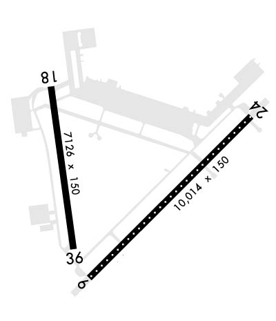
| Lat: N 4000.9 Long: W 07435.5 Elev: 141 Var: +12 Longest Runway: 10014 | ||
| Clr Del: 135.2 Dept. ATIS: 110.6 Arr. ATIS: 110.6 Ground: 121.8 Tower: 118.65 | ||
| ||||||||||||||||||||||||||||||||
| ||||||||||||||||||||||||||||||||
| Rwy | Rwy | |||||||
| 10014x150 | 10014' | 110.10 - 057° | 10014x150 | 10014' | 110.10 - 238° | |||
| 7126x150 | 7126' | 7126x150 | 7126' | |||||
| Runway ID | Single Wheel | Double Wheel | Double Tandem Wheel | Dual Double Wheel |
| 06/24 | N/A | N/A | N/A | N/A |
| 18/36 | N/A | N/A | N/A | N/A |
| These numbers are Advisory and are not limits. The Airport Manager should have more accurate Weight Limits | ||||
 Airport Diagram might not be current. | |
| Facility Name: | MC GUIRE FLD (JOINT BASE MC GUIRE DIX LAKEHURST) |
| City Name: | WRIGHTSTOWN |
| County: | BURLINGTON |
| State abbrev: | NJ |
| State Name: | NEW JERSEY |
| Ownership: | AIR FORCE OWNED |
| Use: | PRIVATE |
| Owner's Name: | USAF JB MCGUIRE DIX LAKEHURST |
| Address: | 2901 FALCON LANE |
| MCGUIRE, NJ 08641 | |
| Owner's Phone: | 609-754-2714 |
| Manager's Name: | CHIEF AIRFIELD MANAGEMENT |
| Address: | 2901 FALCON LANE |
| MCGUIRE, NJ 08641 | |
| Phone: | 609-754-6466 |
| FAA Region: | EASTERN |
| FAA Field Office: | HAR |
| Date | Sunrise | Sunset |
|---|---|---|
| 10/14/24 Monday | 7:09 | 18:19 |
| 10/15/24 Tuesday | 7:10 | 18:18 |
| 10/16/24 Wednesday | 7:11 | 18:16 |
| 10/17/24 Thursday | 7:12 | 18:15 |
| 10/18/24 Friday | 7:13 | 18:13 |
| 10/19/24 Saturday | 7:14 | 18:12 |
| 10/20/24 Sunday | 7:15 | 18:10 |
| 10/21/24 Monday | 7:16 | 18:09 |
| 10/22/24 Tuesday | 7:17 | 18:08 |
| 10/23/24 Wednesday | 7:18 | 18:06 |
| 10/24/24 Thursday | 7:19 | 18:05 |
| 10/25/24 Friday | 7:20 | 18:04 |
| 10/26/24 Saturday | 7:22 | 18:02 |
| 10/27/24 Sunday | 7:23 | 18:01 |
| Airport Attendance Schedule | CONTINUOUS |
| Airport Status | OPERATIONAL (This Status can change at any time - please check NOTAMS) |
| Airport Lighting Schedule | |
| Airport Storage Available | Hanger |
| Extra Services Available | Cargo Handling |
| Wind Indicator | YES - (unlit) |
| Control Tower | YES |
| CTAF Frequency | |
| Unicom Frequency | |
| Rotating Beacon Color | WG |
| Segmented Circle | NO |
| Landing Fee | NO |
| Airport Inspected | No Inspection Data Available performed by the OWNER |
| Inspection Date | Unknown |
| Type of Fuel Available | None |
| Airframe Repair Service | MAJOR |
| Power Plant Repair Service | MAJOR |
| Latitude | N4000.9 |
| Longitude | W07435.5 (ESTIMATED) |
| Arpt Elevation | 140ft (SURVEYED) |
| Magnetic Variation | 12W |
| 2 miles SE | of WRIGHTSTOWN |
| Traffic Pattern Altitude | TPA FOR HEL 600 FT; LGT ACFT 800 FT; RECTANGULAR 1600 FT; OHD 2100 FT. |
| Sectional Chart | NEW YORK |
| Operations (Reported) | Yearly | Avg. Daily |
|---|---|---|
| General Aviation Transient | 0 | 0 |
| General Aviation Local | 0 | 0 |
| Air Taxi | 0 | 0 |
| Commerical | 0 | 0 |
| Commuter | 0 | 0 |
| Military | 0 | 0 |
| Aircraft based on Field | |
|---|---|
| General Aviation Singles | 0 |
| General Aviation Multi | 0 |
| Jet Aircraft | 0 |
| General Aviation Helicopters | 0 |
| Military Aircraft | 0 |
| Gliders | 0 |
| Ultralights | 0 |
| FSS on field | NO |
| FSS tie-in | NEW YORK |
| FSS Phone | 1-800-WX-BRIEF |
| Who issues Notams | WRI |
| Notam D service at airport | YES |
| ARTCC Name | NEW YORK |
| Airport Certification | |
| Aircraft Rescue & Firefighting Index | None |
| Airport of Entry | No |
| Custom Landing Rights | YES |
| Joint Civil/Military | No |
| Military Landing rights | No |
| SERVICE: AOE. |
| RSTD: ALL INBD PAX/CARGO ACFT CTC COMD POST NO LATER THAN 30 MIN PRIOR TO LDG. |
| CAUTION: RWY 18/36 LANDING ZONE MARKINGS MID-FIELD. |
| JASU: (C26) (MD-3) 6(MA-1A) (MA-1). |
| REMARK: 72 HR PPR FOR ARMY RAMP AND LDG ALL ICTN ON FT DIX RESERVATION DSN 562-6377/5287. |
| RWY 18/36 ONLY HAS 200 FT PAVED ASPHALT NON-GROOVED OVERRUNS, REMAINDER OF RWY NOT GROOVED. |
| ASA RAMP OPR 1230-2130Z WKD. WKEND HR BY PRIOR APVL. FAC LCTD ON SW SIDE OF AFLD. 72 HR PPR FOR ARMY RAMP AND LDG ALL LCTN ON FT DIX RESERVAION DSN 562-3451, CELL 609-649-3743. TRAN ACFT CTC ARMY OPS PRIOR TO LDG. |
| FUEL: A++ |
| MISC: ALL CLASSIFIED MATERIAL MUST BE STORED AT THE JB COMD POST DSN 650-3935/3936. AFLD MGMT HAS NO CLASSIFIED STORAGE CAPABILITIES. |
| MISC: FIRST 431 FT RWY 36 CONC REMAINING 6695 FT ASPH. |
| CAUTION: NSTD MRK ON VICTOR ROW FOR ALERT MSN, X-RAY ROW (PRIM), AND ROMEO ROW (ALTN) FOR COMBAT OFF LOAD OPS. |
| FLUID: SP PRESAIR LHOX LOX (C-5, KC-10, 747 DE-ICING LTD TO WG ONLY. 3 HR PN RQR.) |
| OIL: O-128-133-148-156. |
| SERVICE-LGT: RWY 18 PAR AND PAPI NOT COINCIDENTAL. |
| 180 DEG TURNS RSTD TO CONC PORTIONS OF RWYS ONLY. |
| ASA RAMP OPR 1230-2130++. |
| RWY COND CODES (RWYCC) UNAVBL. |
| TRAN ALERT: SVC AVBL H24 DLY. |
| RSTD: TRAN ACFT RQR CUST MUST COORD WITH AIRFIELD MGMT AT TIME OF PPR REQ. |
| AN/FMQ-19 AUTO OBS SYS IN USE, AUGMENTED BY HUMAN OBSN WHEN NEC DURG AFLD HRS. VIS OF AFLD RSTRCTD FROM BASE WX OPS NW-SE DURG MANUAL AUGMENTATION BY WX FCSTR. FULL WX SVC AVBL H24 MON-FRI. LIMITED SVC WKNDS AND HOL (FCSTR ON CALL C609-668-1211); H24 DUR ARC/ANG DRILL WKND. WX FLT DSN 650-1130, C609-754-1130. WHEN WX SVC CLSD, TRAN CREWS CTC 15 OWS AT SCOTT AFB H24 DSN 576-9755/9702, C618-256-9755/9702. DURG EVAC OF WX FLT CTC 15 OWS AT NBR ABV. RON TRAN CREW REQ WX BRIEF PRIOR TO LDG. ATC WILL SUPPLEMENT OBSN AS NEEDED. |
| MISC: ALL TRAN ACFT RQR PPR. REQ APVL THRU AFLD MGMT OPS DSN 650-2714, C609-754-2714; PPRS WILL BE REQ NO EARLIER THAN SEVEN DAYS, AND NO LATER THAN 24 HR PRIOR TO ARR, 48 HR FOR ACFT CARRYING DANGEROUS/HAZ CARGO. AIRCREWS WITH APV PPR THAT DEVIATE FROM COORD ARR TIME BY MORE THAN ONE HR MUST NOTIFY AMOPS ASAP. IF NO NOTIFICATION RCVD AFTER ONE HR, PPR WILL BE TERMINATED. |
| RSTD: DUR BASH PHASE II, ONE-TIME DEP/ARR AUTH'D +/- 1 HR SR/SS UNDER REAL-TIME BWC. REAL-TIME BWC CAN ONLY BE DETERMINED WHEN THE FLD COND ARE AT LEAST 3000 FT/5 STATUTE MILES AND IF TWR CAN VISUALLY CONFIRM A BWC LESS THAN SEVERE. TKOFF AND LDG ARE NOT AUTHORIZED UNLESS APV BY 305 OG/CC FOR 305 AMW, AND USAF TRAN ACFT OR OPS GP COMDR SVC EQUIVALENT FOR TENANT UNITS. ALFA ALERT ACFT ARE EXEMPT FROM THIS REQUIREMENT. COORD WAIVERS THRU COMD POST. |
| RWY 06/2 4 RWY 06/24 UNDER RUNS AVBL FOR DEP. |
| RWY 06/2 4 FIRST 1000 FT OF RWYS 06 AND 24 ARE GROOVED CONC; REMAINDER OF RWY GROOVED ASPHALT. RWY 06/24 HAS HARDENED AND NON-GROOVED OVERRUNS. |
| RWY 18/3 6 FIRST 431 FT RWY 36 CONC, REMAINING 6695 FT ASPHALT. |
Airport Communications & Frequencies:
| |||||||||||||||||||||||||||||||||||||
| Runway: 06 | Runway: 24 | ||
| Mag heading: | 57° | Mag heading: | 237° |
| Rwy Slope: | -.28% Down | Rwy Slope: | .28% Up |
| Approach: | ILS | Approach: | LOC/GS |
| Pattern: | Left Traffic | Pattern: | Right Traffic |
| Markings: | PRECISION INSTRUMENT | Markings: | PRECISION INSTRUMENT |
| Marking Condition: | Marking Condition: | ||
| Arresting Dev: | Arresting Dev: | ||
| Lat & Long: | N4000.3 W07435.9 | Lat. & Long.: | N4001.4 W07434.3 |
| Elev: | 131.2 ft. MSL | Elev: | 103.1 ft. MSL |
| TCH: | 76 ft. AGL | TCH: | 76 ft. AGL |
| Visual Glide Path: | 3.00 degrees | Visual Glide Path: | 3.00 degrees |
| Displaced Threshold: | No | Displaced Threshold: | No |
| Touchdown Zone: | YES | Touchdown Zone: | YES |
| Touchdown Elev.: | 131.2 feet | Touchdown Elev.: | 116.5 feet |
| Visual Glide Slope: | 4-Light PAPI on LEFT side of Runway | Visual Glide Slope: | 4-Light PAPI on LEFT side of Runway |
| RVR Equipment: | TOUCHDOWN-MIDFIELD-ROLLOUT | RVR Equipment: | TOUCHDOWN-ROLLOUT |
| RVV Equipment: | YES | RVV Equipment: | NO |
| Approach Lights: | ALSF2 - standard 2,400 foot high intensity approach lighting system with sequenced flashers, Category II or III | Approach Lights: | ALSF1 - standard 2,400 foot high intensity approach lighting system with sequenced flashers, Category I |
| REIL: | NO | REIL: | NO |
| Centerline Lights: | YES | Centerline Lights: | YES |
| Touchdown lights: | YES | Touchdown lights: | NO |
| Runway Category: | Runway Category: | ||
| Declared Distances: | Declared Distances: |
| Runway: 18 | Runway: 36 | ||
| Mag heading: | 185° | Mag heading: | 5° |
| Rwy Slope: | .09% Up | Rwy Slope: | -.09% Down |
| Approach: | Approach: | ||
| Pattern: | Right Traffic | Pattern: | Left Traffic |
| Markings: | NONPRECISION INSTRUMENT | Markings: | NONPRECISION INSTRUMENT |
| Marking Condition: | Marking Condition: | ||
| Arresting Dev: | Arresting Dev: | ||
| Lat & Long: | N4001.6 W07436.2 | Lat. & Long.: | N4000.5 W07436.0 |
| Elev: | 122.0 ft. MSL | Elev: | 128.5 ft. MSL |
| TCH: | 68 ft. AGL | TCH: | 46 ft. AGL |
| Visual Glide Path: | 3.00 degrees | Visual Glide Path: | 3.00 degrees |
| Displaced Threshold: | No | Displaced Threshold: | No |
| Touchdown Zone: | YES | Touchdown Zone: | YES |
| Touchdown Elev.: | 123.3 feet | Touchdown Elev.: | 128.5 feet |
| Visual Glide Slope: | 4-Light PAPI on LEFT side of Runway | Visual Glide Slope: | 4-Light PAPI on LEFT side of Runway |
| RVR Equipment: | TOUCHDOWN-ROLLOUT | RVR Equipment: | TOUCHDOWN-ROLLOUT |
| RVV Equipment: | NO | RVV Equipment: | NO |
| Approach Lights: | Approach Lights: | ||
| REIL: | YES | REIL: | YES |
| Centerline Lights: | NO | Centerline Lights: | NO |
| Touchdown lights: | NO | Touchdown lights: | NO |
| Runway Category: | Runway Category: | ||
| Declared Distances: | Declared Distances: | ||
| Comments: | PLINE 45 FT HI & 3/4 MI FM APCH END 18. | Comments: |
Thanks for using FltPlan.com
all rights reserved © 1999-2024 by Flight Plan LLC
