
| RIDGELAND RIDGELAND SC |
| |
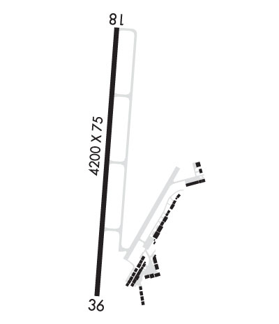
| Lat: N 3229.8 Long: W 08059.6 Elev: 85 Var: +04 Longest Runway: 4200 | ||
| CTAF: 123.07 | ||
| ||||||||||||||||||||||||||||||||||||||||||||
| ||||||||||||||||||||||||||||||||||||||||||||
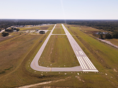
| Rwy | Rwy | |||||||
| 4200x75 | 4200' | 4200x75 | 4200' | |||||
| Runway ID | Single Wheel | Double Wheel | Double Tandem Wheel | Dual Double Wheel |
| 18/36 | 30,000 | 45,000 | N/A | N/A |
| These numbers are Advisory and are not limits. The Airport Manager should have more accurate Weight Limits | ||||
| FltPlan does not have IFR approach charts available for K3J1. |
 Airport Diagram might not be current. | |
| Facility Name: | RIDGELAND-CLAUDE DEAN |
| City Name: | RIDGELAND |
| County: | JASPER |
| State abbrev: | SC |
| State Name: | SOUTH CAROLINA |
| Ownership: | PUBLICLY OWNED |
| Use: | OPEN TO THE PUBLIC |
| Owner's Name: | COUNTY OF JASPER |
| Address: | P.O. BOX 1149, 358 3RD AVENUE |
| RIDGELAND, SC 29936-8785 | |
| Owner's Phone: | (843) 717-3690 |
| Manager's Name: | LEONARD SANSONE |
| Address: | 262 HON. BARBARA B. CLARK DR., PO BOX 653 |
| RIDGELAND, SC 29936 | |
| Phone: | 843-226-0399 |
| FAA Region: | SOUTHERN |
| FAA Field Office: | ATL |
| Date | Sunrise | Sunset |
|---|---|---|
| 06/21/26 Sunday | 6:17 | 20:34 |
| 06/22/26 Monday | 6:17 | 20:35 |
| 06/23/26 Tuesday | 6:17 | 20:35 |
| 06/24/26 Wednesday | 6:18 | 20:35 |
| 06/25/26 Thursday | 6:18 | 20:35 |
| 06/26/26 Friday | 6:18 | 20:35 |
| 06/27/26 Saturday | 6:19 | 20:35 |
| 06/28/26 Sunday | 6:19 | 20:35 |
| 06/29/26 Monday | 6:19 | 20:35 |
| 06/30/26 Tuesday | 6:20 | 20:35 |
| 07/01/26 Wednesday | 6:20 | 20:35 |
| 07/02/26 Thursday | 6:21 | 20:35 |
| 07/03/26 Friday | 6:21 | 20:35 |
| 07/04/26 Saturday | 6:21 | 20:35 |
| Airport Attendance Schedule | MON -SUN 0800-1800; SUN, MON - ON CALL. 843-929-4159 FOR AFTER HOURS FEE AND AVAIL. |
| Airport Status | OPERATIONAL (This Status can change at any time - please check NOTAMS) |
| Airport Lighting Schedule | MIRL RWY 18/36 PRESET LOW INTST; TO INCR INTST CTAF. REIL RWY 18 & 36; PAPI RWY 18 & 36 OPR CONSLY DUSK-DAWN. |
| Airport Storage Available | Tie Downs |
| Extra Services Available | Glider, Glider Towing |
| Wind Indicator | YES - (lighted) |
| Control Tower | NO |
| CTAF Frequency | 123.075 |
| Unicom Frequency | 123.075 |
| Rotating Beacon Color | WG |
| Segmented Circle | YES |
| Landing Fee | NO |
| Airport Inspected | STATE - performed by STATE AERONAUTICAL PERSONNEL |
| Inspection Date | 08/29/2025 |
| Type of Fuel Available | Grade 100LL, JET A (freeze point -40C), JET A; -A+JET A WITH PRIST. |
| Airframe Repair Service | MINOR |
| Power Plant Repair Service | MINOR |
| Latitude | N3229.8 |
| Longitude | W08059.6 (ESTIMATED) |
| Arpt Elevation | 84ft (SURVEYED) |
| Magnetic Variation | 04W |
| 1 miles NW | of RIDGELAND |
| Traffic Pattern Altitude | |
| Sectional Chart | CHARLOTTE |
| Operations (Reported) | Yearly | Avg. Daily |
|---|---|---|
| General Aviation Transient | 0 | 0 |
| General Aviation Local | 0 | 0 |
| Air Taxi | 0 | 0 |
| Commerical | 0 | 0 |
| Commuter | 0 | 0 |
| Military | 0 | 0 |
| Aircraft based on Field | |
|---|---|
| General Aviation Singles | 0 |
| General Aviation Multi | 0 |
| Jet Aircraft | 0 |
| General Aviation Helicopters | 0 |
| Military Aircraft | 0 |
| Gliders | 0 |
| Ultralights | 0 |
| FSS on field | NO |
| FSS tie-in | ANDERSON |
| FSS Phone | 1-800-WX-BRIEF |
| Who issues Notams | AND |
| Notam D service at airport | YES |
| ARTCC Name | JACKSONVILLE |
| Airport Certification | |
| Aircraft Rescue & Firefighting Index | None |
| Airport of Entry | No |
| Custom Landing Rights | No |
| Joint Civil/Military | No |
| Military Landing rights | No |
| NATIONAL PLAN OF INTEGRATED AIRPORT SYSTEMS (NPIAS) |
| GLIDER OPNS INVOF ARPT. |
| FOR CD CTC BEAUFORT APCH AT 843-228-6298, WHEN APCH CLSD CTC JACKSONVILLE ARTCC AT 904-845-1592. |
| FBO LCTD MID-FLD. |
| RWY 36 CALM WIND RWY. |
| Runway: 18 | Runway: 36 | ||
| Mag heading: | 188° | Mag heading: | 8° |
| Rwy Slope: | -.24% Down | Rwy Slope: | .24% Up |
| Approach: | Approach: | ||
| Pattern: | Left Traffic | Pattern: | Left Traffic |
| Markings: | BASIC | Markings: | BASIC |
| Marking Condition: | GOOD | Marking Condition: | GOOD |
| Arresting Dev: | Arresting Dev: | ||
| Lat & Long: | N3230.2 W08059.6 | Lat. & Long.: | N3229.5 W08059.6 |
| Elev: | 84.8 ft. MSL | Elev: | 74.9 ft. MSL |
| TCH: | 40 ft. AGL | TCH: | 40 ft. AGL |
| Visual Glide Path: | 3.00 degrees | Visual Glide Path: | 3.00 degrees |
| Displaced Threshold: | No | Displaced Threshold: | No |
| Touchdown Zone: | YES | Touchdown Zone: | YES |
| Touchdown Elev.: | 84.8 feet | Touchdown Elev.: | 81.9 feet |
| Visual Glide Slope: | 2-Light PAPI on LEFT side of Runway; RWY 18 PAPI UNUSBL BYD 8 DEGS LEFT OF RCL. | Visual Glide Slope: | 2-Light PAPI on LEFT side of Runway |
| RVR Equipment: | RVR Equipment: | ||
| RVV Equipment: | NO | RVV Equipment: | NO |
| Approach Lights: | Approach Lights: | ||
| REIL: | YES | REIL: | YES |
| Centerline Lights: | NO | Centerline Lights: | NO |
| Touchdown lights: | NO | Touchdown lights: | NO |
| Runway Category: | Runway with a Visual Approach | Runway Category: | Runway with a Visual Approach |
| Declared Distances: | Declared Distances: | ||
| Comments: | Comments: | TREE, 10 FT TALL, 166 FT FROM THRESHOLD, 125 FT LEFT OF CENTERLINE |
Thanks for using FltPlan.com
all rights reserved © 1999-2026 by Flight Plan LLC