
| AFTON MUNI AFTON WY |
| |
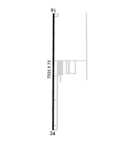
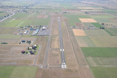
| Lat: N 4242.5 Long: W 11056.5 Elev: 6221 Var: -14 Longest Runway: 7025 | ||
| AWOS: 119.02 CTAF: 122.8 | ||
| ||||||||||||||||||||||||||||||||||||||||||||
| ||||||||||||||||||||||||||||||||||||||||||||
| ||||||||||||||||||||||||||||||||||||||||||||
| Rwy | Rwy | |||||||
| 7025x75 | 7025' | 7025x75 | 7025' | |||||
| Runway ID | Single Wheel | Double Wheel | Double Tandem Wheel | Dual Double Wheel |
| 16/34 | 24,000 | N/A | N/A | N/A |
| These numbers are Advisory and are not limits. The Airport Manager should have more accurate Weight Limits | ||||
 Airport Diagram might not be current. | |
| Facility Name: | AFTON MUNI |
| City Name: | AFTON |
| County: | LINCOLN |
| State abbrev: | WY |
| State Name: | WYOMING |
| Ownership: | PUBLICLY OWNED |
| Use: | OPEN TO THE PUBLIC |
| Owner's Name: | TOWN OF AFTON; ALSO LINCOLN COUNTY-307-877-2004. |
| Address: | BOX 1181 |
| AFTON, WY 83110 | |
| Owner's Phone: | (307) 885-9831 |
| Manager's Name: | RICK SESSIONS |
| Address: | BOX 1181 |
| AFTON, WY 83110 | |
| Phone: | 307-885-3245 |
| FAA Region: | NORTHWEST MOUNTAIN |
| FAA Field Office: | DEN |
| Date | Sunrise | Sunset |
|---|---|---|
| 09/24/21 Friday | 7:13 | 19:18 |
| 09/25/21 Saturday | 7:14 | 19:16 |
| 09/26/21 Sunday | 7:15 | 19:14 |
| 09/27/21 Monday | 7:16 | 19:12 |
| 09/28/21 Tuesday | 7:17 | 19:11 |
| 09/29/21 Wednesday | 7:19 | 19:09 |
| 09/30/21 Thursday | 7:20 | 19:07 |
| 10/01/21 Friday | 7:21 | 19:05 |
| 10/02/21 Saturday | 7:22 | 19:04 |
| 10/03/21 Sunday | 7:23 | 19:02 |
| 10/04/21 Monday | 7:24 | 19:00 |
| 10/05/21 Tuesday | 7:25 | 18:58 |
| 10/06/21 Wednesday | 7:26 | 18:57 |
| 10/07/21 Thursday | 7:28 | 18:55 |
| Airport Attendance Schedule | MON-SAT 0800-1700 |
| Airport Status | OPERATIONAL (This Status can change at any time - please check NOTAMS) |
| Airport Lighting Schedule | ACTVT REIL RWY 16 & 34; MIRL RWY 16/34 - CTAF. PAPI RWY 16 & 34 OPR CONSLY. |
| Airport Storage Available | Tie Downs, Hanger |
| Extra Services Available | Flight Instruction, Aircraft Rental |
| Wind Indicator | YES - (lighted) |
| Control Tower | NO |
| CTAF Frequency | 122.800 |
| Unicom Frequency | 122.800 |
| Rotating Beacon Color | CLEAR-GREEN (Light Land Airport) |
| Segmented Circle | YES |
| Landing Fee | NO |
| Airport Inspected | STATE - performed by STATE AERONAUTICAL PERSONNEL |
| Inspection Date | 06/06/2019 |
| Type of Fuel Available | Grade 100LL, JET A (freeze point -40C); -A FUEL 24 HR CREDIT CARD SVC; FULL SVC JET AVBL. |
| Airframe Repair Service | MAJOR |
| Power Plant Repair Service | MAJOR |
| Latitude | N4242.5 |
| Longitude | W11056.5 (ESTIMATED) |
| Arpt Elevation | 6220ft (SURVEYED) |
| Magnetic Variation | 14E |
| 1 miles SW | of AFTON |
| Traffic Pattern Altitude | |
| Sectional Chart | SALT LAKE CITY |
| Operations (Reported) | Yearly | Avg. Daily |
|---|---|---|
| General Aviation Transient | 3944 | 11 |
| General Aviation Local | 4760 | 13 |
| Air Taxi | 312 | 1 |
| Commerical | 0 | 0 |
| Commuter | 0 | 0 |
| Military | 0 | 0 |
| Aircraft based on Field | |
|---|---|
| General Aviation Singles | 40 |
| General Aviation Multi | 1 |
| Jet Aircraft | 3 |
| General Aviation Helicopters | 0 |
| Military Aircraft | 0 |
| Gliders | 0 |
| Ultralights | 0 |
| FSS on field | NO |
| FSS tie-in | CASPER |
| FSS Phone | 1-800-WX-BRIEF |
| Who issues Notams | CPR |
| Notam D service at airport | YES |
| ARTCC Name | SALT LAKE CITY |
| Airport Certification | |
| Aircraft Rescue & Firefighting Index | None |
| Airport of Entry | No |
| Custom Landing Rights | No |
| Joint Civil/Military | No |
| Military Landing rights | No |
| NATIONAL PLAN OF INTEGRATED AIRPORT SYSTEMS (NPIAS) |
| GRANT AGREEMENTS UNDER FAAP/ADAP/AIP |
| ASSURANCES PURSUANT TO TITLE VI, CIVIL RIGHTS ACT OF 1964 |
| SNBNKS 4' TO 7' ALONG RWYS & TXYS EDGES FROM OCT-MAY WITH SLICK SPOTS ALL SFCS. |
| COLD TEMPERATURE RESTRICTED AIRPORT. ALTITUDE CORRECTION REQUIRED AT OR BELOW -22C. |
| FOR CD CTC SALT LAKE ARTCC AT 801-320-2568. |
Airport Communications & Frequencies:
| |||||||||
| Runway: 16 | Runway: 34 | ||
| Mag heading: | 166° | Mag heading: | 346° |
| Rwy Slope: | .47% Up | Rwy Slope: | -.47% Down |
| Approach: | Approach: | ||
| Pattern: | Right Traffic | Pattern: | Left Traffic |
| Markings: | NONPRECISION INSTRUMENT | Markings: | NONPRECISION INSTRUMENT |
| Marking Condition: | FAIR | Marking Condition: | FAIR |
| Arresting Dev: | Arresting Dev: | ||
| Lat & Long: | N4243.1 W11056.5 | Lat. & Long.: | N4241.9 W11056.5 |
| Elev: | 6187.7 ft. MSL | Elev: | 6220.9 ft. MSL |
| TCH: | 52 ft. AGL | TCH: | 52 ft. AGL |
| Visual Glide Path: | 3.50 degrees | Visual Glide Path: | 3.50 degrees |
| Displaced Threshold: | No | Displaced Threshold: | No |
| Touchdown Zone: | YES | Touchdown Zone: | YES |
| Touchdown Elev.: | 6187.7 feet | Touchdown Elev.: | 6220.9 feet |
| Visual Glide Slope: | 4-Light PAPI on LEFT side of Runway; RY 16 PAPI DOES NOT PROVIDE OBST CLNC BYD 5.0 NM FRM THLD, UNUSBL BYD 5.0 NM. | Visual Glide Slope: | 4-Light PAPI on LEFT side of Runway; RY 34 PAPI DOES NOT PROVIDE OBST CLNC BYD 5.0 NM FRM THLD, UNUSBL BYD 5.0 NM. |
| RVR Equipment: | RVR Equipment: | ||
| RVV Equipment: | NO | RVV Equipment: | NO |
| Approach Lights: | Approach Lights: | ||
| REIL: | YES | REIL: | YES |
| Centerline Lights: | NO | Centerline Lights: | NO |
| Touchdown lights: | NO | Touchdown lights: | NO |
| Runway Category: | Runway with a Non-precision Approach having visibility minimums greater than 3/4 mile | Runway Category: | Runway with a Non-precision Approach having visibility minimums greater than 3/4 mile |
| Declared Distances: | Declared Distances: | ||
| Obstructions: | POLE | Obstructions: | TREE |
| Marked: | NOT Marked/Lighted | Marked: | NOT Marked/Lighted |
| Clearance slope: | 21:1 | Clearance slope: | 19:1 |
| Obstruction height: | 51 feet AGL | Obstruction height: | 90 feet AGL |
| Dist. from runway: | 1290 feet | Dist. from runway: | 2014 feet |
| Centerline offset: | 278 left of centerline | Centerline offset: | 185 feet right of centerline |
| Comments: | Comments: |
Thanks for using FltPlan.com
all rights reserved © 1999-2021 by Flight Plan LLC