
| H.A. CLARK MEMORIAL FIELD WILLIAMS AZ |
| |
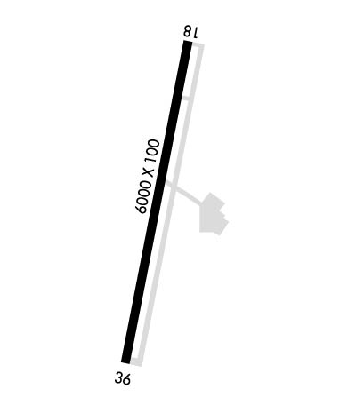
| Lat: N 3518.3 Long: W 11211.7 Elev: 6691 Var: -13 Longest Runway: 6003 | ||
| AWOS: 121.12 CTAF: 122.8 | ||
| ||||||||||||||||||||||||||||||||||||||||||||
| ||||||||||||||||||||||||||||||||||||||||||||
| ||||||||||||||||||||||||||||||||||||||||||||
| Rwy | Rwy | |||||||
| 6003x100 | 6003' | 6003x100 | 6003' | |||||
| Runway ID | Single Wheel | Double Wheel | Double Tandem Wheel | Dual Double Wheel |
| 18/36 | N/A | N/A | N/A | N/A |
| These numbers are Advisory and are not limits. The Airport Manager should have more accurate Weight Limits | ||||
 Airport Diagram might not be current. | |
| Facility Name: | H A CLARK MEML FLD |
| City Name: | WILLIAMS |
| County: | COCONINO |
| State abbrev: | AZ |
| State Name: | ARIZONA |
| Ownership: | PUBLICLY OWNED |
| Use: | OPEN TO THE PUBLIC |
| Owner's Name: | CITY OF WILLIAMS |
| Address: | 113 S FIRST ST |
| WILLIAMS, AZ 86046 | |
| Owner's Phone: | 928-635-4451 |
| Manager's Name: | BRAD OLSON; EMERG - 928-635-4461 WILLIAMS POLICE DEPT. |
| Address: | 3501 NORTH AIRPORT ROAD |
| WILLIAMS, AZ 86046 | |
| Phone: | 928-635-8982; 928-300-8353 |
| FAA Region: | WESTERN-PACIFIC |
| FAA Field Office: | PHX |
| Date | Sunrise | Sunset |
|---|---|---|
| 04/28/25 Monday | 5:41 | 19:12 |
| 04/29/25 Tuesday | 5:40 | 19:13 |
| 04/30/25 Wednesday | 5:39 | 19:14 |
| 05/01/25 Thursday | 5:38 | 19:15 |
| 05/02/25 Friday | 5:37 | 19:15 |
| 05/03/25 Saturday | 5:36 | 19:16 |
| 05/04/25 Sunday | 5:34 | 19:17 |
| 05/05/25 Monday | 5:33 | 19:18 |
| 05/06/25 Tuesday | 5:33 | 19:19 |
| 05/07/25 Wednesday | 5:32 | 19:20 |
| 05/08/25 Thursday | 5:31 | 19:20 |
| 05/09/25 Friday | 5:30 | 19:21 |
| 05/10/25 Saturday | 5:29 | 19:22 |
| 05/11/25 Sunday | 5:28 | 19:23 |
| Airport Attendance Schedule | WED-SUN 0800-1500 |
| Airport Status | OPERATIONAL (This Status can change at any time - please check NOTAMS) |
| Airport Lighting Schedule | ACTVT REIL RWY 18 & 36; PAPI RWY 18 & 36; MIRL RWY 18/36 - CTAF. |
| Airport Storage Available | Tie Downs, Hanger |
| Extra Services Available | NONE |
| Wind Indicator | YES - (lighted) |
| Control Tower | NO |
| CTAF Frequency | 122.800 |
| Unicom Frequency | 122.800 |
| Rotating Beacon Color | WG |
| Segmented Circle | YES |
| Landing Fee | NO |
| Airport Inspected | STATE - performed by PRIVATE CONTRACT PERSONNEL |
| Inspection Date | 05/11/2022 |
| Type of Fuel Available | Grade 100LL, JET A-1 (icing inhibitor, freeze point -50C); -10SELF SVC WITH CREDIT CARD H24.; -A1FULL SVC AVBL BY APPT - AMGR OR 928-300-8385. |
| Airframe Repair Service | MAJOR |
| Power Plant Repair Service | MAJOR |
| Latitude | N3518.3 |
| Longitude | W11211.7 (ESTIMATED) |
| Arpt Elevation | 6690ft (SURVEYED) |
| Magnetic Variation | 13E |
| 3 miles N | of WILLIAMS |
| Traffic Pattern Altitude | |
| Sectional Chart | PHOENIX |
| Operations (Reported) | Yearly | Avg. Daily |
|---|---|---|
| General Aviation Transient | 0 | 0 |
| General Aviation Local | 0 | 0 |
| Air Taxi | 0 | 0 |
| Commerical | 0 | 0 |
| Commuter | 0 | 0 |
| Military | 0 | 0 |
| Aircraft based on Field | |
|---|---|
| General Aviation Singles | 0 |
| General Aviation Multi | 0 |
| Jet Aircraft | 0 |
| General Aviation Helicopters | 0 |
| Military Aircraft | 0 |
| Gliders | 0 |
| Ultralights | 0 |
| FSS on field | NO |
| FSS tie-in | PRESCOTT |
| FSS Phone | 1-800-WX-BRIEF |
| Who issues Notams | PRC |
| Notam D service at airport | YES |
| ARTCC Name | ALBUQUERQUE |
| Airport Certification | |
| Aircraft Rescue & Firefighting Index | None |
| Airport of Entry | No |
| Custom Landing Rights | No |
| Joint Civil/Military | No |
| Military Landing rights | YES |
| NATIONAL PLAN OF INTEGRATED AIRPORT SYSTEMS (NPIAS) |
| GRANT AGREEMENTS UNDER FAAP/ADAP/AIP |
| CONVEYANCE UNDER SCETION 16, FEDERAL AIRPORT ACT OF 1946 OR SECTION 23, AIRPORT AND AIRWAY DEVELOPMENT ACT OF 1970 |
| ASSURANCES PURSUANT TO TITLE VI, CIVIL RIGHTS ACT OF 1964 |
| FOR CD CTC ALBUQUERQUE ARTCC AT 505-856-4861. |
| WINTER FICON - AMGR. |
| RWY 18/3 6 10-15 FT TREES & BRUSH 120 FT W OF CNTRLN FULL LEN. |
| RWY 18 393 FT HILL 7800 FT FM RWY END ON CNTRLN. |
| RWY 36 479 FT HILL 8800 FT FM RWY END ON CNTRLN. |
Airport Communications & Frequencies:
| |||||||||
| Runway: 18 | Runway: 36 | ||
| Mag heading: | 178° | Mag heading: | 358° |
| Rwy Slope: | 1.01% Up | Rwy Slope: | -1.01% Down |
| Approach: | Approach: | ||
| Pattern: | Left Traffic | Pattern: | Left Traffic |
| Markings: | NONPRECISION INSTRUMENT | Markings: | NONPRECISION INSTRUMENT |
| Marking Condition: | GOOD | Marking Condition: | GOOD |
| Arresting Dev: | Arresting Dev: | ||
| Lat & Long: | N3518.8 W11211.5 | Lat. & Long.: | N3517.8 W11211.8 |
| Elev: | 6630.2 ft. MSL | Elev: | 6690.8 ft. MSL |
| TCH: | 46 ft. AGL | TCH: | 50 ft. AGL |
| Visual Glide Path: | 3.00 degrees | Visual Glide Path: | 3.00 degrees |
| Displaced Threshold: | No | Displaced Threshold: | No |
| Touchdown Zone: | YES | Touchdown Zone: | YES |
| Touchdown Elev.: | 6660.6 feet | Touchdown Elev.: | 6690.8 feet |
| Visual Glide Slope: | 2-Light PAPI on LEFT side of Runway | Visual Glide Slope: | 2-Light PAPI on LEFT side of Runway |
| RVR Equipment: | RVR Equipment: | ||
| RVV Equipment: | NO | RVV Equipment: | NO |
| Approach Lights: | Approach Lights: | ||
| REIL: | YES | REIL: | YES |
| Centerline Lights: | NO | Centerline Lights: | NO |
| Touchdown lights: | NO | Touchdown lights: | NO |
| Runway Category: | Runway with a Visual Approach | Runway Category: | Runway with a Visual Approach |
| Declared Distances: | Declared Distances: | ||
| Obstructions: | TREE | Obstructions: | |
| Marked: | NOT Marked/Lighted | Marked: | |
| Clearance slope: | 2:1 | Clearance slope: | 20:1 |
| Obstruction height: | 12 feet AGL | Obstruction height: | |
| Dist. from runway: | 230 feet | Dist. from runway: | |
| Centerline offset: | 180 right of centerline | Centerline offset: | |
| Comments: | +3 FT BERM 65-200 FT FM RWY END 150 FT L & R; 13 FT TREE 170 FT FM RWY END 175 FT R. | Comments: | +5 FT ROCK 20-75 FT FM THR 175-250 FT FM CNTRLN. |
Thanks for using FltPlan.com
all rights reserved © 1999-2025 by Flight Plan LLC
