
| WICKENBURG MUNI WICKENBURG AZ |
| |
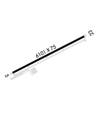
| Lat: N 3358.2 Long: W 11247.7 Elev: 2379 Var: -13 Longest Runway: 6101 | ||
| AWOS: 121.37 CTAF: 123.0 | ||
| ||||||||||||||||||||||||||||||||||||||||||||
| ||||||||||||||||||||||||||||||||||||||||||||
| ||||||||||||||||||||||||||||||||||||||||||||
| Rwy | Rwy | |||||||
| 6101x75 | 6101' | 6101x75 | 6101' | |||||
| Runway ID | Single Wheel | Double Wheel | Double Tandem Wheel | Dual Double Wheel |
| 05/23 | 30,000 | 60,000 | N/A | N/A |
| These numbers are Advisory and are not limits. The Airport Manager should have more accurate Weight Limits | ||||
| FltPlan does not have IFR approach charts available for KE25. |
 Airport Diagram might not be current. | |
| Facility Name: | WICKENBURG MUNI |
| City Name: | WICKENBURG |
| County: | MARICOPA |
| State abbrev: | AZ |
| State Name: | ARIZONA |
| Ownership: | PUBLICLY OWNED |
| Use: | OPEN TO THE PUBLIC |
| Owner's Name: | TOWN OF WICKENBURG |
| Address: | 155 NORTH TEGNER ST SUITE A |
| WICKENBURG, AZ 85390 | |
| Owner's Phone: | 928-684-5451; AIRPORT CTC INFORMATION AVBL AT WWW.WICKENBURGAZ.ORG. |
| Manager's Name: | HERSCHEL WORKMAN |
| Address: | 155 NORTH TEGNER ST SUITE A |
| WICKENBURG, AZ 85390 | |
| Phone: | 928-668-0564 |
| FAA Region: | WESTERN-PACIFIC |
| FAA Field Office: | PHX |
| Date | Sunrise | Sunset |
|---|---|---|
| 09/24/21 Friday | 6:21 | 18:25 |
| 09/25/21 Saturday | 6:21 | 18:24 |
| 09/26/21 Sunday | 6:22 | 18:23 |
| 09/27/21 Monday | 6:23 | 18:21 |
| 09/28/21 Tuesday | 6:23 | 18:20 |
| 09/29/21 Wednesday | 6:24 | 18:18 |
| 09/30/21 Thursday | 6:25 | 18:17 |
| 10/01/21 Friday | 6:26 | 18:16 |
| 10/02/21 Saturday | 6:26 | 18:14 |
| 10/03/21 Sunday | 6:27 | 18:13 |
| 10/04/21 Monday | 6:28 | 18:12 |
| 10/05/21 Tuesday | 6:28 | 18:10 |
| 10/06/21 Wednesday | 6:29 | 18:09 |
| 10/07/21 Thursday | 6:30 | 18:08 |
| Airport Attendance Schedule | TUE-SAT 0700-1600; AFTER HRS CTC (928) 232-0397 |
| Airport Status | OPERATIONAL (This Status can change at any time - please check NOTAMS) |
| Airport Lighting Schedule | ACTVT REIL RWY 05 & 23; MIRL RWY 05/23, TWY LGTS - CTAF. PAPI RWY 05 & 23 ON FROM DAWN-DUSK, PAPI RYS 05 & 23 DUSK-DAWN - CTAF. |
| Airport Storage Available | Tie Downs |
| Extra Services Available | NONE |
| Wind Indicator | YES - (lighted) |
| Control Tower | NO |
| CTAF Frequency | 123.000 |
| Unicom Frequency | 123.000 |
| Rotating Beacon Color | CLEAR-GREEN (Light Land Airport) |
| Segmented Circle | YES |
| Landing Fee | NO |
| Airport Inspected | STATE - performed by PRIVATE CONTRACT PERSONNEL |
| Inspection Date | 04/11/2021 |
| Type of Fuel Available | Grade 100LL, JET A-1 (icing inhibitor, freeze point -50C); -10SELF-FUELING AVAILABLE 24/7 WITH MAJOR CREDIT CARD. JET 'A' AVAILABLE WITH CALL-OUT OF $100 AFTER 1600 AND ON SUN & MON. |
| Airframe Repair Service | MINOR |
| Power Plant Repair Service | MINOR |
| Latitude | N3358.2 |
| Longitude | W11247.7 (ESTIMATED) |
| Arpt Elevation | 2378ft (SURVEYED) |
| Magnetic Variation | 13E |
| 3 miles W | of WICKENBURG |
| Traffic Pattern Altitude | |
| Sectional Chart | PHOENIX |
| Operations (Reported) | Yearly | Avg. Daily |
|---|---|---|
| General Aviation Transient | 24200 | 66 |
| General Aviation Local | 11500 | 32 |
| Air Taxi | 400 | 1 |
| Commerical | 0 | 0 |
| Commuter | 0 | 0 |
| Military | 50 | 0 |
| Aircraft based on Field | |
|---|---|
| General Aviation Singles | 12 |
| General Aviation Multi | 1 |
| Jet Aircraft | 0 |
| General Aviation Helicopters | 0 |
| Military Aircraft | 0 |
| Gliders | 1 |
| Ultralights | 2 |
| FSS on field | NO |
| FSS tie-in | PRESCOTT |
| FSS Phone | 1-800-WX-BRIEF |
| Who issues Notams | PRC |
| Notam D service at airport | YES |
| ARTCC Name | ALBUQUERQUE |
| Airport Certification | |
| Aircraft Rescue & Firefighting Index | None |
| Airport of Entry | No |
| Custom Landing Rights | No |
| Joint Civil/Military | No |
| Military Landing rights | YES |
| NATIONAL PLAN OF INTEGRATED AIRPORT SYSTEMS (NPIAS) |
| GRANT AGREEMENTS UNDER FAAP/ADAP/AIP |
| ASSURANCES PURSUANT TO TITLE VI, CIVIL RIGHTS ACT OF 1964 |
| CONVEYANCE UNDER SCETION 16, FEDERAL AIRPORT ACT OF 1946 OR SECTION 23, AIRPORT AND AIRWAY DEVELOPMENT ACT OF 1970 |
| RWY 23 HAS 150 FT BLAST PAD. |
| RWY 05 HAS 150 FT BLAST PAD. |
| WILDLIFE ON OR INVOF ARPT. |
| ALL LIGHTS ON DIRECTIONAL & HOLD SIGNS AND DISTANCE TO GO MARKERS ARE INOP. |
| FOR CD CTC LUKE APCH AT 623-856-7361. IF UNA, CTC PHOENIX APCH AT 602-306-2565. |
| Runway: 05 | Runway: 23 | ||
| Mag heading: | 47° | Mag heading: | 227° |
| Rwy Slope: | -1.17% Down | Rwy Slope: | 1.17% Up |
| Approach: | Approach: | ||
| Pattern: | Left Traffic | Pattern: | Right Traffic |
| Markings: | NONPRECISION INSTRUMENT | Markings: | NONPRECISION INSTRUMENT |
| Marking Condition: | GOOD | Marking Condition: | GOOD |
| Arresting Dev: | Arresting Dev: | ||
| Lat & Long: | N3358.0 W11248.2 | Lat. & Long.: | N3358.5 W11247.2 |
| Elev: | 2378.4 ft. MSL | Elev: | 2307.3 ft. MSL |
| TCH: | 45 ft. AGL | TCH: | 40 ft. AGL |
| Visual Glide Path: | 3.00 degrees | Visual Glide Path: | 3.00 degrees |
| Displaced Threshold: | No | Displaced Threshold: | No |
| Touchdown Zone: | YES | Touchdown Zone: | YES |
| Touchdown Elev.: | 2378.6 feet | Touchdown Elev.: | 2344.0 feet |
| Visual Glide Slope: | 4-Light PAPI on LEFT side of Runway | Visual Glide Slope: | 4-Light PAPI on LEFT side of Runway |
| RVR Equipment: | RVR Equipment: | ||
| RVV Equipment: | NO | RVV Equipment: | NO |
| Approach Lights: | Approach Lights: | ||
| REIL: | YES | REIL: | YES |
| Centerline Lights: | NO | Centerline Lights: | NO |
| Touchdown lights: | NO | Touchdown lights: | NO |
| Runway Category: | Runway with a Visual Approach | Runway Category: | Runway with a Visual Approach |
| Declared Distances: | Declared Distances: | ||
| Obstructions: | GND | Obstructions: | |
| Marked: | NOT Marked/Lighted | Marked: | |
| Clearance slope: | Clearance slope: | 50:1 | |
| Obstruction height: | 3 feet AGL | Obstruction height: | |
| Dist. from runway: | 201 feet | Dist. from runway: | |
| Centerline offset: | 100 left of centerline | Centerline offset: | |
| Comments: | RWY 05, 1-3 FT BRUSH 50-190 FT FM THLD, 40 FT L & R OF CNTRLN. | Comments: | RY 05, 1 FT-3 FT BRUSH 0 FT-200 FT FM THRESHOLD, 50 FT - 70 FT R OF CNTRLN. |
Thanks for using FltPlan.com
all rights reserved © 1999-2021 by Flight Plan LLC
