
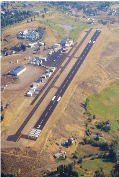
| HUNT FIELD LANDER WY |
| |
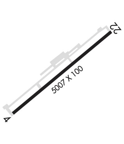
| Lat: N 4248.9 Long: W 10843.7 Elev: 5589 Var: -10 Longest Runway: 5000 | ||
| AWOS: 118.35 CTAF: 122.8 | ||
| ||||||
| ||||||
| ||||||
|
| Rwy | Rwy | |||||||
| 5000x75 | 5000' | 5000x75 | 5000' | |||||
| Runway ID | Single Wheel | Double Wheel | Double Tandem Wheel | Dual Double Wheel |
| 04/22 | 30,000 | N/A | N/A | N/A |
| These numbers are Advisory and are not limits. The Airport Manager should have more accurate Weight Limits | ||||
 Airport Diagram might not be current. | |
| Facility Name: | HUNT FLD |
| City Name: | LANDER |
| County: | FREMONT |
| State abbrev: | WY |
| State Name: | WYOMING |
| Ownership: | PUBLICLY OWNED |
| Use: | OPEN TO THE PUBLIC |
| Owner's Name: | CITY OF LANDER |
| Address: | 240 LINCOLN ST |
| LANDER, WY 82520 | |
| Owner's Phone: | 307-332-2870 |
| Manager's Name: | GARY LOOSE |
| Address: | BOX 1331 |
| LANDER, WY 82520 | |
| Phone: | 307-332-3134 |
| FAA Region: | NORTHWEST MOUNTAIN |
| FAA Field Office: | DEN |
| Date | Sunrise | Sunset |
|---|---|---|
| 09/24/21 Friday | 7:04 | 19:09 |
| 09/25/21 Saturday | 7:05 | 19:07 |
| 09/26/21 Sunday | 7:06 | 19:05 |
| 09/27/21 Monday | 7:07 | 19:04 |
| 09/28/21 Tuesday | 7:09 | 19:02 |
| 09/29/21 Wednesday | 7:10 | 19:00 |
| 09/30/21 Thursday | 7:11 | 18:58 |
| 10/01/21 Friday | 7:12 | 18:57 |
| 10/02/21 Saturday | 7:13 | 18:55 |
| 10/03/21 Sunday | 7:14 | 18:53 |
| 10/04/21 Monday | 7:15 | 18:51 |
| 10/05/21 Tuesday | 7:16 | 18:50 |
| 10/06/21 Wednesday | 7:18 | 18:48 |
| 10/07/21 Thursday | 7:19 | 18:46 |
| Airport Attendance Schedule | 7 Days A Week 0600-1600; FOR SERVICE AFT HRS CALL 307-330-8668. |
| Airport Status | OPERATIONAL (This Status can change at any time - please check NOTAMS) |
| Airport Lighting Schedule | ACTVT REIL RWY 4 & 22; MIRL RWY 04/22 - CTAF; PAPI RWY 04 & 22 OPR CONSLY. |
| Airport Storage Available | Tie Downs, Hanger |
| Extra Services Available | Air Ambulance, Flight Instruction |
| Wind Indicator | YES - (lighted) |
| Control Tower | NO |
| CTAF Frequency | 122.800 |
| Unicom Frequency | 122.800 |
| Rotating Beacon Color | CLEAR-GREEN (Light Land Airport) |
| Segmented Circle | YES |
| Landing Fee | NO |
| Airport Inspected | STATE - performed by STATE AERONAUTICAL PERSONNEL |
| Inspection Date | 07/15/2021 |
| Type of Fuel Available | Grade 100LL, JET A (freeze point -40C); -10FUEL AVBL 24 HRS SELF SERV CREDIT CARD |
| Airframe Repair Service | MAJOR |
| Power Plant Repair Service | MAJOR; POWERPLANT RPRS LTD TO PISTON ENGINES ONLY. |
| Latitude | N4248.9 |
| Longitude | W10843.7 (ESTIMATED) |
| Arpt Elevation | 5588ft (SURVEYED) |
| Magnetic Variation | 10E |
| 1 miles S | of LANDER |
| Traffic Pattern Altitude | |
| Sectional Chart | CHEYENNE |
| Operations (Reported) | Yearly | Avg. Daily |
|---|---|---|
| General Aviation Transient | 4400 | 12 |
| General Aviation Local | 5500 | 15 |
| Air Taxi | 90 | 0 |
| Commerical | 0 | 0 |
| Commuter | 0 | 0 |
| Military | 10 | 0 |
| Aircraft based on Field | |
|---|---|
| General Aviation Singles | 40 |
| General Aviation Multi | 5 |
| Jet Aircraft | 1 |
| General Aviation Helicopters | 1 |
| Military Aircraft | 0 |
| Gliders | 0 |
| Ultralights | 1 |
| FSS on field | NO |
| FSS tie-in | CASPER |
| FSS Phone | 1-800-WX-BRIEF |
| Who issues Notams | LND |
| Notam D service at airport | YES |
| ARTCC Name | SALT LAKE CITY |
| Airport Certification | |
| Aircraft Rescue & Firefighting Index | None |
| Airport of Entry | No |
| Custom Landing Rights | No |
| Joint Civil/Military | No |
| Military Landing rights | YES |
| NATIONAL PLAN OF INTEGRATED AIRPORT SYSTEMS (NPIAS) |
| GRANT AGREEMENTS UNDER FAAP/ADAP/AIP |
| ASSURANCES PURSUANT TO TITLE VI, CIVIL RIGHTS ACT OF 1964 |
| BIRD ACTIVITY INVOF ARPT. |
| FOR CD CTC SALT LAKE ARTCC AT 801-320-2568. |
| RWY 22 TWR 305 FT ABV APCH END 14728 FT FM RWY END 90 FT RIGHT OF CNTRLN. |
Airport Communications & Frequencies:
| |||||||||
| Runway: 04 | Runway: 22 | ||
| Mag heading: | 40° | Mag heading: | 220° |
| Rwy Slope: | -.64% Down | Rwy Slope: | .64% Up |
| Approach: | Approach: | ||
| Pattern: | Left Traffic | Pattern: | Left Traffic; RIGHT TRAFFIC PATTERNS PERMS ON RWY 22 DEPARTURE DURING HEAVY WIND TO AVOID THE MOUNTAINS DUE TO SEVERE DOWN DRAFTS. |
| Markings: | NONPRECISION INSTRUMENT | Markings: | NONPRECISION INSTRUMENT |
| Marking Condition: | GOOD | Marking Condition: | GOOD |
| Arresting Dev: | Arresting Dev: | ||
| Lat & Long: | N4248.7 W10844.1 | Lat. & Long.: | N4249.2 W10843.3 |
| Elev: | 5588.9 ft. MSL | Elev: | 5556.9 ft. MSL |
| TCH: | 41 ft. AGL | TCH: | 41 ft. AGL |
| Visual Glide Path: | 3.00 degrees | Visual Glide Path: | 3.00 degrees |
| Displaced Threshold: | No | Displaced Threshold: | No |
| Touchdown Zone: | YES | Touchdown Zone: | YES |
| Touchdown Elev.: | 5588.9 feet | Touchdown Elev.: | 5576.7 feet |
| Visual Glide Slope: | 2-Light PAPI on LEFT side of Runway; PAPI RWY 04 UNUSBL BYD 2 NM. | Visual Glide Slope: | 2-Light PAPI on LEFT side of Runway |
| RVR Equipment: | RVR Equipment: | ||
| RVV Equipment: | NO | RVV Equipment: | NO |
| Approach Lights: | Approach Lights: | ||
| REIL: | YES | REIL: | YES |
| Centerline Lights: | NO | Centerline Lights: | NO |
| Touchdown lights: | NO | Touchdown lights: | NO |
| Runway Category: | Runway with a Visual Approach | Runway Category: | Runway with a Non-precision Approach having visibility minimums greater than 3/4 mile |
| Declared Distances: | Declared Distances: | ||
| Obstructions: | TREE | Obstructions: | |
| Marked: | NOT Marked/Lighted | Marked: | |
| Clearance slope: | 24:1 | Clearance slope: | 34:1 |
| Obstruction height: | 135 feet AGL | Obstruction height: | |
| Dist. from runway: | 3538 feet | Dist. from runway: | |
| Centerline offset: | 250 right of centerline | Centerline offset: | |
| Comments: | Comments: |
Thanks for using FltPlan.com
all rights reserved © 1999-2021 by Flight Plan LLC