| MARCO ISLAND MARCO ISLAND FL |
| |
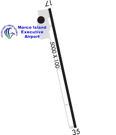
| Lat: N 2559.7 Long: W 08140.4 Elev: 5 Var: +03 Longest Runway: 5000 | ||
| Clr Del: 120.8 AWOS: 120.07 CTAF: 122.7 | ||
| |||||||||||||||||||||||||||||||||||||||||||||||||||||||||||||||||||||
| |||||||||||||||||||||||||||||||||||||||||||||||||||||||||||||||||||||
| |||||||||||||||||||||||||||||||||||||||||||||||||||||||||||||||||||||
| Rwy | Rwy | |||||||
| 5000x100 | 5000' | 109.95 - 170° | 5000x100 | 5000' | ||||
| Runway ID | Single Wheel | Double Wheel | Double Tandem Wheel | Dual Double Wheel |
| 17/35 | 75,000 | 108,000 | N/A | N/A |
| These numbers are Advisory and are not limits. The Airport Manager should have more accurate Weight Limits | ||||
 Airport Diagram might not be current. | |
| Facility Name: | MARCO ISLAND EXEC |
| City Name: | MARCO ISLAND |
| County: | COLLIER |
| State abbrev: | FL |
| State Name: | FLORIDA |
| Ownership: | PUBLICLY OWNED |
| Use: | OPEN TO THE PUBLIC |
| Owner's Name: | COLLIER COUNTY AIRPORT AUTHORITY |
| Address: | 2005 MAINSAIL DRIVE, SUITE 1 |
| NAPLES, FL 34114 | |
| Owner's Phone: | (239)394-3355 |
| Manager's Name: | JUSTIN E. LOBB |
| Address: | 2005 MAINSAIL DRIVE, SUITE 1 |
| NAPLES, FL 34114 | |
| Phone: | 239 642-7878 |
| FAA Region: | SOUTHERN |
| FAA Field Office: | ORL |
| Date | Sunrise | Sunset |
|---|---|---|
| 09/24/21 Friday | 7:16 | 19:21 |
| 09/25/21 Saturday | 7:16 | 19:20 |
| 09/26/21 Sunday | 7:17 | 19:19 |
| 09/27/21 Monday | 7:17 | 19:18 |
| 09/28/21 Tuesday | 7:18 | 19:17 |
| 09/29/21 Wednesday | 7:18 | 19:16 |
| 09/30/21 Thursday | 7:18 | 19:15 |
| 10/01/21 Friday | 7:19 | 19:13 |
| 10/02/21 Saturday | 7:19 | 19:12 |
| 10/03/21 Sunday | 7:20 | 19:11 |
| 10/04/21 Monday | 7:20 | 19:10 |
| 10/05/21 Tuesday | 7:21 | 19:09 |
| 10/06/21 Wednesday | 7:21 | 19:08 |
| 10/07/21 Thursday | 7:22 | 19:07 |
| Airport Attendance Schedule | 7 Days A Week 0700-1900 |
| Airport Status | OPERATIONAL (This Status can change at any time - please check NOTAMS) |
| Airport Lighting Schedule | ACTVT REIL RWY 17 & 35; PAPI RWY 17 & 35; MIRL RWY 17/35 - CTAF. |
| Airport Storage Available | Tie Downs |
| Extra Services Available | Charter, Flight Instruction, Aircraft Rental |
| Wind Indicator | YES - (lighted) |
| Control Tower | NO |
| CTAF Frequency | 122.700 |
| Unicom Frequency | 122.700 |
| Rotating Beacon Color | CLEAR-GREEN (Light Land Airport) |
| Segmented Circle | YES |
| Landing Fee | NO; RAMP FEE |
| Airport Inspected | STATE - performed by STATE AERONAUTICAL PERSONNEL |
| Inspection Date | 10/10/2018 |
| Type of Fuel Available | Grade 100LL, JET A (freeze point -40C), JET A; -10SELF SVC AVGAS 100LL AVBL 24 HRS BY CREDIT CARD. |
| Airframe Repair Service | MINOR |
| Power Plant Repair Service | MINOR |
| Latitude | N2559.7 |
| Longitude | W08140.4 (ESTIMATED) |
| Arpt Elevation | 5ft (SURVEYED) |
| Magnetic Variation | 03W |
| 4 miles NE | of MARCO ISLAND |
| Traffic Pattern Altitude | |
| Sectional Chart | MIAMI |
| Operations (Reported) | Yearly | Avg. Daily |
|---|---|---|
| General Aviation Transient | 24400 | 67 |
| General Aviation Local | 29300 | 80 |
| Air Taxi | 4600 | 13 |
| Commerical | 0 | 0 |
| Commuter | 0 | 0 |
| Military | 130 | 0 |
| Aircraft based on Field | |
|---|---|
| General Aviation Singles | 29 |
| General Aviation Multi | 1 |
| Jet Aircraft | 1 |
| General Aviation Helicopters | 2 |
| Military Aircraft | 0 |
| Gliders | 0 |
| Ultralights | 0 |
| FSS on field | NO |
| FSS tie-in | MIAMI |
| FSS Phone | 1-800-WX-BRIEF |
| Who issues Notams | MIA |
| Notam D service at airport | YES |
| ARTCC Name | MIAMI |
| Airport Certification | |
| Aircraft Rescue & Firefighting Index | None |
| Airport of Entry | No |
| Custom Landing Rights | No |
| Joint Civil/Military | No |
| Military Landing rights | No |
| NATIONAL PLAN OF INTEGRATED AIRPORT SYSTEMS (NPIAS) |
| ASSURANCES PURSUANT TO TITLE VI, CIVIL RIGHTS ACT OF 1964 |
| FOR CD CTC FORT MYERS APCH AT 239-768-1377, WHEN APCH CLSD CTC MIAMI ARTCC AT 305-716-1731. |
| ARPT VSBY UNRELIABLE. |
| NOISE SENSITIVE AREA. USE NBAA CLOSE IN NOISE ABATEMMENT PROCEDURES. |
| BANNER TOWING ON AND INVOF ARPT. |
| FOR FUEL AND SVC AFTER HRS CALL 239-394-3355. |
| NUMEROUS BIRDS & WILDLIFE ON AND INVOF ARPT. |
Airport Communications & Frequencies:
| |||||||||||||||||||
| Runway: 17 | Runway: 35 | ||
| Mag heading: | 171° | Mag heading: | 351° |
| Rwy Slope: | .00% Up | Rwy Slope: | .00% Down |
| Approach: | LOCALIZER | Approach: | |
| Pattern: | Left Traffic | Pattern: | Right Traffic |
| Markings: | NONPRECISION INSTRUMENT | Markings: | NONPRECISION INSTRUMENT |
| Marking Condition: | FAIR | Marking Condition: | FAIR |
| Arresting Dev: | Arresting Dev: | ||
| Lat & Long: | N2600.1 W08140.4 | Lat. & Long.: | N2559.3 W08140.3 |
| Elev: | 5.0 ft. MSL | Elev: | 5.1 ft. MSL |
| TCH: | 31 ft. AGL | TCH: | 32 ft. AGL |
| Visual Glide Path: | 3.00 degrees | Visual Glide Path: | 3.00 degrees |
| Displaced Threshold: | No | Displaced Threshold: | No |
| Touchdown Zone: | YES | Touchdown Zone: | YES |
| Touchdown Elev.: | 5.1 feet | Touchdown Elev.: | 5.2 feet |
| Visual Glide Slope: | 4-Light PAPI on LEFT side of Runway | Visual Glide Slope: | 4-Light PAPI on LEFT side of Runway |
| RVR Equipment: | RVR Equipment: | ||
| RVV Equipment: | NO | RVV Equipment: | NO |
| Approach Lights: | Approach Lights: | ||
| REIL: | YES | REIL: | YES |
| Centerline Lights: | NO | Centerline Lights: | NO |
| Touchdown lights: | NO | Touchdown lights: | NO |
| Runway Category: | Runway with a Non-precision Approach having visibility minimums greater than 3/4 mile | Runway Category: | Runway with a Non-precision Approach having visibility minimums greater than 3/4 mile |
| Declared Distances: | Declared Distances: | ||
| Obstructions: | BRUSH | Obstructions: | BRUSH |
| Marked: | NOT Marked/Lighted | Marked: | NOT Marked/Lighted |
| Clearance slope: | 1:1; RY 17 APCH RATIO 24:1 TO RY END. | Clearance slope: | 25:1 |
| Obstruction height: | 10 feet AGL | Obstruction height: | 7 feet AGL |
| Dist. from runway: | 210 feet | Dist. from runway: | 365 feet |
| Centerline offset: | 180 left of centerline | Centerline offset: | |
| Comments: | Comments: |
Thanks for using FltPlan.com
all rights reserved © 1999-2021 by Flight Plan LLC