| KNOX COUNTY RGNL ROCKLAND ME |
| |
| Lat: N 4403.6 Long: W 06906.0 Elev: 55 Var: +18 Longest Runway: 5412 | ||
| Clr Del: 123.8 AWOS: 119.02 CTAF: 123.05 | ||
| ||||||||||||||||||||||||||||||||||||||||||||||||||||||||||||||||||||
| ||||||||||||||||||||||||||||||||||||||||||||||||||||||||||||||||||||
| ||||||||||||||||||||||||||||||||||||||||||||||||||||||||||||||||||||
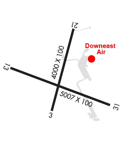
| Rwy | Rwy | |||||||
| 4000x100 | 4000' | 4000x100 | 4000' | |||||
| 5412x100 | 5012' | 111.70 - 128° | 5412x100 | 5412' | ||||
| Runway ID | Single Wheel | Double Wheel | Double Tandem Wheel | Dual Double Wheel |
| 03/21 | 65,000 | 80,000 | N/A | N/A |
| 13/31 | 65,000 | 80,000 | N/A | N/A |
| These numbers are Advisory and are not limits. The Airport Manager should have more accurate Weight Limits | ||||
 Airport Diagram might not be current. | |
| Facility Name: | KNOX COUNTY RGNL |
| City Name: | ROCKLAND |
| County: | KNOX |
| State abbrev: | ME |
| State Name: | MAINE |
| Ownership: | PUBLICLY OWNED |
| Use: | OPEN TO THE PUBLIC |
| Owner's Name: | KNOX COUNTY |
| Address: | 62 UNION ST |
| ROCKLAND, ME 04841 | |
| Owner's Phone: | 207-594-0420 |
| Manager's Name: | JEFF NORTHGRAVES |
| Address: | 5 AIRPORT ROAD |
| OWLS HEAD, ME 04854 | |
| Phone: | 207-594-4131 |
| FAA Region: | NEW ENGLAND |
| FAA Field Office: | NONE |
| Date | Sunrise | Sunset |
|---|---|---|
| 09/24/21 Friday | 6:26 | 18:31 |
| 09/25/21 Saturday | 6:27 | 18:29 |
| 09/26/21 Sunday | 6:28 | 18:27 |
| 09/27/21 Monday | 6:29 | 18:25 |
| 09/28/21 Tuesday | 6:30 | 18:23 |
| 09/29/21 Wednesday | 6:31 | 18:21 |
| 09/30/21 Thursday | 6:33 | 18:20 |
| 10/01/21 Friday | 6:34 | 18:18 |
| 10/02/21 Saturday | 6:35 | 18:16 |
| 10/03/21 Sunday | 6:36 | 18:14 |
| 10/04/21 Monday | 6:37 | 18:12 |
| 10/05/21 Tuesday | 6:38 | 18:10 |
| 10/06/21 Wednesday | 6:40 | 18:09 |
| 10/07/21 Thursday | 6:41 | 18:07 |
| Airport Attendance Schedule | MON-FRI 0600-1700; ARPT MAY BE UNATNDD FM 2200 UNTIL 0600. |
| Airport Status | OPERATIONAL (This Status can change at any time - please check NOTAMS) |
| Airport Lighting Schedule | ACTVT MALSR RWY 13; REIL RWY 03 & 31; PAPI RWY 03, 13 & 31; HIRL RWY 13/31; MIRL RWY 03/21 - CTAF. |
| Airport Storage Available | Tie Downs, Hanger |
| Extra Services Available | Air Freight, Charter, Flight Instruction, Aircraft Rental |
| Wind Indicator | YES - (lighted) |
| Control Tower | NO |
| CTAF Frequency | 123.050 |
| Unicom Frequency | 123.050 |
| Rotating Beacon Color | CLEAR-GREEN (Light Land Airport) |
| Segmented Circle | YES |
| Landing Fee | NO |
| Airport Inspected | STATE - performed by PRIVATE CONTRACT PERSONNEL |
| Inspection Date | 08/12/2019 |
| Type of Fuel Available | Grade 100LL, JET A (freeze point -40C) |
| Airframe Repair Service | MAJOR |
| Power Plant Repair Service | MAJOR |
| Latitude | N4403.6 |
| Longitude | W06906.0 (ESTIMATED) |
| Arpt Elevation | 55ft (SURVEYED) |
| Magnetic Variation | 18W |
| 3 miles S | of ROCKLAND |
| Traffic Pattern Altitude | |
| Sectional Chart | MONTREAL |
| Operations (Reported) | Yearly | Avg. Daily |
|---|---|---|
| General Aviation Transient | 14068 | 39 |
| General Aviation Local | 11997 | 33 |
| Air Taxi | 9903 | 27 |
| Commerical | 2812 | 8 |
| Commuter | 0 | 0 |
| Military | 109 | 0 |
| Aircraft based on Field | |
|---|---|
| General Aviation Singles | 62 |
| General Aviation Multi | 1 |
| Jet Aircraft | 3 |
| General Aviation Helicopters | 0 |
| Military Aircraft | 0 |
| Gliders | 1 |
| Ultralights | 0 |
| FSS on field | NO |
| FSS tie-in | BANGOR |
| FSS Phone | 1-800-WX-BRIEF |
| Who issues Notams | RKD |
| Notam D service at airport | YES |
| ARTCC Name | BOSTON |
| Airport Certification | |
| Aircraft Rescue & Firefighting Index | None |
| Airport of Entry | No |
| Custom Landing Rights | No |
| Joint Civil/Military | No |
| Military Landing rights | YES |
| NATIONAL PLAN OF INTEGRATED AIRPORT SYSTEMS (NPIAS) |
| GRANT AGREEMENTS UNDER FAAP/ADAP/AIP |
| SURPLUS PROPERTY AGREEMENT UNDER PUBLIC LAW 289 |
| SURPLUS PROPERTY AGREEMENT UNDER REGULATION 16-WAA |
| ASSURANCES PURSUANT TO TITLE VI, CIVIL RIGHTS ACT OF 1964 |
| AGREEMENT UNDER DLAND OR DCLA HAS EXPIRED. |
| DEER & SEAGULLS ON & INVOF ARPT. |
| VOLUNTARY NGT CUFREW IN EFCT 2230-0600. |
| NOISE ABATEMENT PROCS IN EFCT, CALL 207-596-0617 OR VISIT WEBSITE FOR SPECIFIC INSTRNS. |
| FOR CD WHEN APCH CLSD CTC BOSTON ARTCC AT 603-879-6859. |
Airport Communications & Frequencies:
| |||||||||||||||||||
| Runway: 03 | Runway: 21 | ||
| Mag heading: | 31° | Mag heading: | 211° |
| Rwy Slope: | .12% Up | Rwy Slope: | -.12% Down |
| Approach: | Approach: | ||
| Pattern: | Left Traffic | Pattern: | Left Traffic |
| Markings: | NONPRECISION INSTRUMENT | Markings: | NONPRECISION INSTRUMENT |
| Marking Condition: | GOOD | Marking Condition: | GOOD |
| Arresting Dev: | Arresting Dev: | ||
| Lat & Long: | N4403.4 W06906.0 | Lat. & Long.: | N4404.0 W06905.8 |
| Elev: | 50.2 ft. MSL | Elev: | 55.1 ft. MSL |
| TCH: | 34 ft. AGL | TCH: | |
| Visual Glide Path: | 3.00 degrees | Visual Glide Path: | |
| Displaced Threshold: | No | Displaced Threshold: | No |
| Touchdown Zone: | YES | Touchdown Zone: | YES |
| Touchdown Elev.: | 54.2 feet | Touchdown Elev.: | 55.1 feet |
| Visual Glide Slope: | 4-Light PAPI on LEFT side of Runway | Visual Glide Slope: | |
| RVR Equipment: | RVR Equipment: | ||
| RVV Equipment: | NO | RVV Equipment: | NO |
| Approach Lights: | Approach Lights: | ||
| REIL: | YES | REIL: | NO |
| Centerline Lights: | NO | Centerline Lights: | NO |
| Touchdown lights: | NO | Touchdown lights: | NO |
| Runway Category: | Runway with a Non-precision Approach having visibility minimums greater than 3/4 mile | Runway Category: | Runway with a Visual Approach |
| Declared Distances: | TORA:4000' TODA:4000' ASDA:4000' LDA:4000' | Declared Distances: | TORA:4000' TODA:4000' ASDA:4000' LDA:4000' |
| Obstructions: | TREES | Obstructions: | TREES |
| Marked: | NOT Marked/Lighted | Marked: | NOT Marked/Lighted |
| Clearance slope: | 5:1 | Clearance slope: | 12:1 |
| Obstruction height: | 20 feet AGL | Obstruction height: | 22 feet AGL |
| Dist. from runway: | 310 feet | Dist. from runway: | 470 feet |
| Centerline offset: | 240 left of centerline | Centerline offset: | 145 feet left of centerline |
| Comments: | Comments: |
| Runway: 13 | Runway: 31 | ||
| Mag heading: | 129° | Mag heading: | 309° |
| Rwy Slope: | .17% Up | Rwy Slope: | -.17% Down |
| Approach: | ILS/DME | Approach: | |
| Pattern: | Left Traffic | Pattern: | Left Traffic |
| Markings: | PRECISION INSTRUMENT | Markings: | PRECISION INSTRUMENT |
| Marking Condition: | GOOD | Marking Condition: | GOOD |
| Arresting Dev: | Arresting Dev: | ||
| Lat & Long: | N4403.7 W06906.6 | Lat. & Long.: | N4403.4 W06905.4 |
| Elev: | 45.6 ft. MSL | Elev: | 54.7 ft. MSL |
| TCH: | 51 ft. AGL | TCH: | 50 ft. AGL |
| Visual Glide Path: | 3.00 degrees | Visual Glide Path: | 3.00 degrees |
| Displaced Threshold: | 400 feet | Displaced Threshold: | No |
| Touchdown Zone: | YES | Touchdown Zone: | YES |
| Touchdown Elev.: | 53.5 feet | Touchdown Elev.: | 55.4 feet |
| Visual Glide Slope: | 4-Light PAPI on RIGHT side of Runway | Visual Glide Slope: | 4-Light PAPI on LEFT side of Runway |
| RVR Equipment: | RVR Equipment: | ||
| RVV Equipment: | NO | RVV Equipment: | NO |
| Approach Lights: | MALSR - 1,400 foot medium intensity approach lighting system with runway alignment indicator lights | Approach Lights: | |
| REIL: | NO | REIL: | YES |
| Centerline Lights: | NO | Centerline Lights: | NO |
| Touchdown lights: | NO | Touchdown lights: | NO |
| Runway Category: | Precision Instrument Runway | Runway Category: | Runway with a Non-precision Approach having visibility minimums greater than 3/4 mile |
| Declared Distances: | TORA:5412' TODA:5412' ASDA:5412' LDA:5012' | Declared Distances: | TORA:5412' TODA:5412' ASDA:5412' LDA:5412' |
| Obstructions: | BRUSH | Obstructions: | TREES |
| Marked: | NOT Marked/Lighted | Marked: | NOT Marked/Lighted |
| Clearance slope: | Clearance slope: | 6:1 | |
| Obstruction height: | 4 feet AGL | Obstruction height: | 40 feet AGL |
| Dist. from runway: | 201 feet | Dist. from runway: | 450 feet |
| Centerline offset: | 285 left of centerline | Centerline offset: | 475 feet right of centerline |
| Comments: | +4 FT- 5 FT BRUSH 150 FT- 200 FT FM THR, 250 FT- 365 FT LEFT OF CNTRLN. | Comments: | +3 FT- 5 FT BRUSH 100 FT- 200 FT FM THR, 230 FT- 500 FT LEFT OF CNTRLN. |
Thanks for using FltPlan.com
all rights reserved © 1999-2021 by Flight Plan LLC