
| ROBEN-HOOD BIG RAPIDS MI |
| |
| Lat: N 4343.4 Long: W 08530.2 Elev: 990 Var: +05 Longest Runway: 4300 | ||
| AWOS: 125.87 CTAF: 122.8 | ||
| ||||||||||||||||||||||||||||||||||||||||||||
| ||||||||||||||||||||||||||||||||||||||||||||
| ||||||||||||||||||||||||||||||||||||||||||||
| Rwy | Rwy | |||||||
| 4300x75 | 4300' | 4300x75 | 4300' | |||||
| 2699x75 | 2699' | 2699x75 | 2699' | |||||
| Runway ID | Single Wheel | Double Wheel | Double Tandem Wheel | Dual Double Wheel |
| 09/27 | 62,000 | 87,000 | N/A | N/A |
| 14/32 | 37,000 | 56,000 | N/A | N/A |
| These numbers are Advisory and are not limits. The Airport Manager should have more accurate Weight Limits | ||||
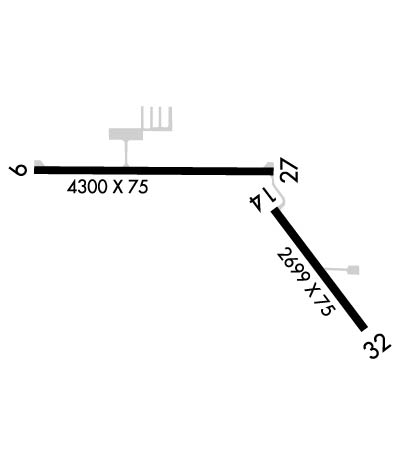 Airport Diagram might not be current. | |
| Facility Name: | ROBEN-HOOD |
| City Name: | BIG RAPIDS |
| County: | MECOSTA |
| State abbrev: | MI |
| State Name: | MICHIGAN |
| Ownership: | PUBLICLY OWNED |
| Use: | OPEN TO THE PUBLIC |
| Owner's Name: | CITY OF BIG RAPIDS |
| Address: | CITY HALL |
| BIG RAPIDS, MI 49307 | |
| Owner's Phone: | 231-592-4045 |
| Manager's Name: | STEVE SCHROEDER; DEPUTY DIR. PUBLIC SAFETY/ARPT MGR. 231-679-1583 (CITY HALL) |
| Address: | 21325 18 MILE RD |
| BIG RAPIDS, MI 49307 | |
| Phone: | 231-796-5600 |
| FAA Region: | GREAT LAKES |
| FAA Field Office: | DET |
| Date | Sunrise | Sunset |
|---|---|---|
| 09/24/21 Friday | 7:31 | 19:36 |
| 09/25/21 Saturday | 7:32 | 19:34 |
| 09/26/21 Sunday | 7:33 | 19:32 |
| 09/27/21 Monday | 7:35 | 19:31 |
| 09/28/21 Tuesday | 7:36 | 19:29 |
| 09/29/21 Wednesday | 7:37 | 19:27 |
| 09/30/21 Thursday | 7:38 | 19:25 |
| 10/01/21 Friday | 7:39 | 19:23 |
| 10/02/21 Saturday | 7:40 | 19:22 |
| 10/03/21 Sunday | 7:42 | 19:20 |
| 10/04/21 Monday | 7:43 | 19:18 |
| 10/05/21 Tuesday | 7:44 | 19:16 |
| 10/06/21 Wednesday | 7:45 | 19:14 |
| 10/07/21 Thursday | 7:46 | 19:13 |
| Airport Attendance Schedule | MON-FRI 0800-1700, SAT 0800-1500 |
| Airport Status | OPERATIONAL (This Status can change at any time - please check NOTAMS) |
| Airport Lighting Schedule | ACTVT MIRL RYS 09/27 & 14/32; PAPI RYS 09 & 27; REIL RYS 09 & 27 - CTAF. |
| Airport Storage Available | Tie Downs, Hanger |
| Extra Services Available | Air Ambulance |
| Wind Indicator | YES - (lighted) |
| Control Tower | NO |
| CTAF Frequency | 122.800 |
| Unicom Frequency | 122.800 |
| Rotating Beacon Color | CLEAR-GREEN (Light Land Airport) |
| Segmented Circle | NO |
| Landing Fee | NO; LDG FEE FOR BUS & CORP ACFT, WAIVED WITH MIN. FUEL PURCH. |
| Airport Inspected | STATE - performed by STATE AERONAUTICAL PERSONNEL |
| Inspection Date | 11/06/2017 |
| Type of Fuel Available | Grade 100LL, JET A-1 (icing inhibitor, freeze point -50C); -1024 HRS SELF-SERVE FUEL. SINGLE POINT & OVERWING AVBL FOR JET A+. |
| Airframe Repair Service | MAJOR |
| Power Plant Repair Service | MAJOR |
| Latitude | N4343.4 |
| Longitude | W08530.2 (ESTIMATED) |
| Arpt Elevation | 989ft (SURVEYED) |
| Magnetic Variation | 05W |
| 2 miles NW | of BIG RAPIDS |
| Traffic Pattern Altitude | |
| Sectional Chart | CHICAGO |
| Operations (Reported) | Yearly | Avg. Daily |
|---|---|---|
| General Aviation Transient | 2020 | 6 |
| General Aviation Local | 2020 | 6 |
| Air Taxi | 0 | 0 |
| Commerical | 0 | 0 |
| Commuter | 0 | 0 |
| Military | 0 | 0 |
| Aircraft based on Field | |
|---|---|
| General Aviation Singles | 17 |
| General Aviation Multi | 2 |
| Jet Aircraft | 0 |
| General Aviation Helicopters | 1 |
| Military Aircraft | 0 |
| Gliders | 0 |
| Ultralights | 0 |
| FSS on field | NO |
| FSS tie-in | LANSING |
| FSS Phone | 1-800-WX-BRIEF |
| Who issues Notams | RQB |
| Notam D service at airport | YES |
| ARTCC Name | MINNEAPOLIS |
| Airport Certification | |
| Aircraft Rescue & Firefighting Index | None |
| Airport of Entry | No |
| Custom Landing Rights | No |
| Joint Civil/Military | No |
| Military Landing rights | YES |
| NATIONAL PLAN OF INTEGRATED AIRPORT SYSTEMS (NPIAS) |
| GRANT AGREEMENTS UNDER FAAP/ADAP/AIP |
| ASSURANCES PURSUANT TO TITLE VI, CIVIL RIGHTS ACT OF 1964 |
| BIRDS & DEER ON & INVOF ARPT. |
| ADMIN. BLDG. ACCESS, DEPRESS 5, THEN 3-2 SIMULTANEOUSLY, THEN 1. |
| FOR CD CTC MINNEAPOLIS ARTCC AT 651-463-5588. |
Airport Communications & Frequencies:
| |||||||||
| Runway: 09 | Runway: 27 | ||
| Mag heading: | 95° | Mag heading: | 275° |
| Rwy Slope: | -1.04% Down | Rwy Slope: | 1.04% Up |
| Approach: | Approach: | ||
| Pattern: | Left Traffic | Pattern: | Left Traffic |
| Markings: | NONPRECISION INSTRUMENT | Markings: | NONPRECISION INSTRUMENT |
| Marking Condition: | FAIR | Marking Condition: | FAIR |
| Arresting Dev: | Arresting Dev: | ||
| Lat & Long: | N4343.5 W08531.0 | Lat. & Long.: | N4343.5 W08530.0 |
| Elev: | 989.5 ft. MSL | Elev: | 944.6 ft. MSL |
| TCH: | 25 ft. AGL | TCH: | 25 ft. AGL |
| Visual Glide Path: | 3.33 degrees | Visual Glide Path: | 3.08 degrees |
| Displaced Threshold: | No | Displaced Threshold: | No |
| Touchdown Zone: | YES | Touchdown Zone: | YES |
| Touchdown Elev.: | 989.8 feet | Touchdown Elev.: | 975.5 feet |
| Visual Glide Slope: | 2-Light PAPI on LEFT side of Runway; PAPI UNUSBL BYD 5 DEG RIGHT OF CNTRLN. | Visual Glide Slope: | 4-Light PAPI on LEFT side of Runway |
| RVR Equipment: | RVR Equipment: | ||
| RVV Equipment: | NO | RVV Equipment: | NO |
| Approach Lights: | Approach Lights: | ||
| REIL: | YES | REIL: | YES |
| Centerline Lights: | NO | Centerline Lights: | NO |
| Touchdown lights: | NO | Touchdown lights: | NO |
| Runway Category: | Runway with a Non-precision Approach | Runway Category: | Runway with a Non-precision Approach |
| Declared Distances: | Declared Distances: | ||
| Obstructions: | TREES | Obstructions: | Unknown |
| Marked: | NOT Marked/Lighted | Marked: | NOT Marked/Lighted |
| Clearance slope: | 21:1 | Clearance slope: | 30:1 |
| Obstruction height: | 98 feet AGL | Obstruction height: | 46 feet AGL |
| Dist. from runway: | 2340 feet | Dist. from runway: | 1600 feet |
| Centerline offset: | Centerline offset: | 250 feet right of centerline | |
| Comments: | Comments: |
| Runway: 14 | Runway: 32 | ||
| Mag heading: | 148° | Mag heading: | 328° |
| Rwy Slope: | -.28% Down | Rwy Slope: | .28% Up |
| Approach: | Approach: | ||
| Pattern: | Left Traffic | Pattern: | Left Traffic |
| Markings: | BASIC | Markings: | BASIC |
| Marking Condition: | FAIR | Marking Condition: | FAIR |
| Arresting Dev: | Arresting Dev: | ||
| Lat & Long: | N4343.4 W08530.0 | Lat. & Long.: | N4343.0 W08529.6 |
| Elev: | 932.4 ft. MSL | Elev: | 924.9 ft. MSL |
| TCH: | TCH: | ||
| Visual Glide Path: | Visual Glide Path: | ||
| Displaced Threshold: | No | Displaced Threshold: | No |
| Touchdown Zone: | YES | Touchdown Zone: | YES |
| Touchdown Elev.: | 932.4 feet | Touchdown Elev.: | 932.4 feet |
| Visual Glide Slope: | Visual Glide Slope: | ||
| RVR Equipment: | RVR Equipment: | ||
| RVV Equipment: | NO | RVV Equipment: | NO |
| Approach Lights: | Approach Lights: | ||
| REIL: | NO | REIL: | NO |
| Centerline Lights: | NO | Centerline Lights: | NO |
| Touchdown lights: | NO | Touchdown lights: | NO |
| Runway Category: | Runway with a Non-precision Approach | Runway Category: | Runway with a Non-precision Approach |
| Declared Distances: | Declared Distances: | ||
| Obstructions: | TREES | Obstructions: | TREE |
| Marked: | NOT Marked/Lighted | Marked: | NOT Marked/Lighted |
| Clearance slope: | 22:1 | Clearance slope: | 21:1 |
| Obstruction height: | 99 feet AGL | Obstruction height: | 57 feet AGL |
| Dist. from runway: | 2360 feet | Dist. from runway: | 1403 feet |
| Centerline offset: | 125 left of centerline | Centerline offset: | 240 feet right of centerline |
| Comments: | Comments: |
Thanks for using FltPlan.com
all rights reserved © 1999-2021 by Flight Plan LLC
