| CULBERSON COUNTY VAN HORN TX |
| |
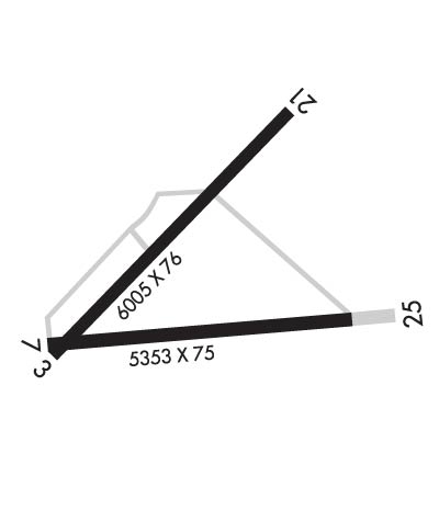
| Lat: N 3103.5 Long: W 10447.0 Elev: 3957 Var: -10 Longest Runway: 6005 | ||
| CTAF: 122.9 | ||
| |||||||||||||||||||||||
| |||||||||||||||||||||||
| Rwy | Rwy | |||||||
| 6005x76 | 6005' | 6005x76 | 6005' | |||||
| 5353x75 | 5353' | 5353x75 | 5353' | |||||
| Runway ID | Single Wheel | Double Wheel | Double Tandem Wheel | Dual Double Wheel |
| 03/21 | 15,000 | N/A | N/A | N/A |
| 07/25 | 15,000 | N/A | N/A | N/A |
| These numbers are Advisory and are not limits. The Airport Manager should have more accurate Weight Limits | ||||
 Airport Diagram might not be current. | |
| Facility Name: | CULBERSON COUNTY |
| City Name: | VAN HORN |
| County: | CULBERSON |
| State abbrev: | TX |
| State Name: | TEXAS |
| Ownership: | PUBLICLY OWNED |
| Use: | OPEN TO THE PUBLIC |
| Owner's Name: | CULBERSON COUNTY |
| Address: | PO BOX 927 |
| VAN HORN, TX 79855 | |
| Owner's Phone: | 915-283-2059 |
| Manager's Name: | LARRY SIMPSON |
| Address: | BOX 1060 |
| VAN HORN, TX 79855 | |
| Phone: | 432-283-2920 |
| FAA Region: | SOUTHWEST |
| FAA Field Office: | TEX |
| Date | Sunrise | Sunset |
|---|---|---|
| 09/24/21 Friday | 7:48 | 19:53 |
| 09/25/21 Saturday | 7:49 | 19:52 |
| 09/26/21 Sunday | 7:50 | 19:51 |
| 09/27/21 Monday | 7:50 | 19:50 |
| 09/28/21 Tuesday | 7:51 | 19:48 |
| 09/29/21 Wednesday | 7:51 | 19:47 |
| 09/30/21 Thursday | 7:52 | 19:46 |
| 10/01/21 Friday | 7:53 | 19:44 |
| 10/02/21 Saturday | 7:53 | 19:43 |
| 10/03/21 Sunday | 7:54 | 19:42 |
| 10/04/21 Monday | 7:55 | 19:41 |
| 10/05/21 Tuesday | 7:55 | 19:40 |
| 10/06/21 Wednesday | 7:56 | 19:38 |
| 10/07/21 Thursday | 7:56 | 19:37 |
| Airport Attendance Schedule | 7 Days A Week 0900-1800 |
| Airport Status | OPERATIONAL (This Status can change at any time - please check NOTAMS) |
| Airport Lighting Schedule | SS-SR |
| Airport Storage Available | Tie Downs |
| Extra Services Available | NONE |
| Wind Indicator | YES - (lighted) |
| Control Tower | NO |
| CTAF Frequency | 122.900 |
| Unicom Frequency | |
| Rotating Beacon Color | CLEAR-GREEN (Light Land Airport) |
| Segmented Circle | YES |
| Landing Fee | NO |
| Airport Inspected | STATE - performed by STATE AERONAUTICAL PERSONNEL |
| Inspection Date | 05/22/2018 |
| Type of Fuel Available | Grade 100LL, JET A-1 (icing inhibitor, freeze point -50C); -10FOR FUEL CALL 432-283-2237 OR 432-284-1418. |
| Airframe Repair Service | None |
| Power Plant Repair Service | None |
| Latitude | N3103.5 |
| Longitude | W10447.0 (ESTIMATED) |
| Arpt Elevation | 3956ft (SURVEYED) |
| Magnetic Variation | 10E |
| 3 miles NE | of VAN HORN |
| Traffic Pattern Altitude | |
| Sectional Chart | EL PASO |
| Operations (Reported) | Yearly | Avg. Daily |
|---|---|---|
| General Aviation Transient | 3000 | 8 |
| General Aviation Local | 120 | 0 |
| Air Taxi | 0 | 0 |
| Commerical | 0 | 0 |
| Commuter | 0 | 0 |
| Military | 360 | 1 |
| Aircraft based on Field | |
|---|---|
| General Aviation Singles | 1 |
| General Aviation Multi | 0 |
| Jet Aircraft | 0 |
| General Aviation Helicopters | 0 |
| Military Aircraft | 0 |
| Gliders | 0 |
| Ultralights | 0 |
| FSS on field | NO |
| FSS tie-in | ALBUQUERQUE |
| FSS Phone | 1-800-WX-BRIEF |
| Who issues Notams | ABQ |
| Notam D service at airport | YES |
| ARTCC Name | ALBUQUERQUE |
| Airport Certification | |
| Aircraft Rescue & Firefighting Index | None |
| Airport of Entry | No |
| Custom Landing Rights | No |
| Joint Civil/Military | No |
| Military Landing rights | YES |
| NATIONAL PLAN OF INTEGRATED AIRPORT SYSTEMS (NPIAS) |
| GRANT AGREEMENTS UNDER FAAP/ADAP/AIP |
| ASSURANCES PURSUANT TO TITLE VI, CIVIL RIGHTS ACT OF 1964 |
| AGREEMENT UNDER DLAND OR DCLA HAS EXPIRED. |
| FOR CD CTC ALBUQUERQUE ARTCC AT 505-856-4861. |
| RWY 03/2 1 RWY 21 HAS NSTD LENSES. NORTH SIDE HAS SPLIT CLEAR/AMBER. SOUTH SIDE HAS CLEAR LENSES. |
Airport Communications & Frequencies:
| |||||||
| Runway: 03 | Runway: 21 | ||
| Mag heading: | 35° | Mag heading: | 215° |
| Rwy Slope: | -.63% Down | Rwy Slope: | .63% Up |
| Approach: | Approach: | ||
| Pattern: | Left Traffic | Pattern: | Left Traffic |
| Markings: | NONPRECISION INSTRUMENT | Markings: | NONPRECISION INSTRUMENT |
| Marking Condition: | GOOD | Marking Condition: | GOOD |
| Arresting Dev: | Arresting Dev: | ||
| Lat & Long: | N3103.3 W10447.5 | Lat. & Long.: | N3104.0 W10446.7 |
| Elev: | 3956.0 ft. MSL | Elev: | 3918.3 ft. MSL |
| TCH: | 23 ft. AGL | TCH: | 24 ft. AGL |
| Visual Glide Path: | 3.00 degrees | Visual Glide Path: | 3.00 degrees |
| Displaced Threshold: | No | Displaced Threshold: | No |
| Touchdown Zone: | YES | Touchdown Zone: | YES |
| Touchdown Elev.: | 3956.2 feet | Touchdown Elev.: | 3939.2 feet |
| Visual Glide Slope: | 2-Box VASI on RIGHT side of Runway | Visual Glide Slope: | 2-Box VASI on LEFT side of Runway; VASI OTS. |
| RVR Equipment: | RVR Equipment: | ||
| RVV Equipment: | NO | RVV Equipment: | NO |
| Approach Lights: | Approach Lights: | ||
| REIL: | NO | REIL: | NO |
| Centerline Lights: | NO | Centerline Lights: | NO |
| Touchdown lights: | NO | Touchdown lights: | NO |
| Runway Category: | Runway with a Visual Approach | Runway Category: | Runway with a Non-precision Approach having visibility minimums greater than 3/4 mile |
| Declared Distances: | Declared Distances: | ||
| Obstructions: | BRUSH | Obstructions: | BRUSH |
| Marked: | NOT Marked/Lighted | Marked: | NOT Marked/Lighted |
| Clearance slope: | Clearance slope: | ||
| Obstruction height: | 10 feet AGL | Obstruction height: | 10 feet AGL |
| Dist. from runway: | 200 feet | Dist. from runway: | 200 feet |
| Centerline offset: | 250 left of centerline | Centerline offset: | 126 feet right of centerline |
| Comments: | Comments: | SCATTERED 10 FT BRUSH FM THLD TO 200 FT FM THLD 138 FT LEFT AND 132 FT RIGHT. |
| Runway: 07 | Runway: 25 | ||
| Mag heading: | 74° | Mag heading: | 254° |
| Rwy Slope: | -.86% Down | Rwy Slope: | .86% Up |
| Approach: | Approach: | ||
| Pattern: | Left Traffic | Pattern: | Left Traffic |
| Markings: | BASIC | Markings: | BASIC |
| Marking Condition: | POOR; PAINT MARKINGS FADED. | Marking Condition: | POOR; PAINT MARKINGS FADED. |
| Arresting Dev: | Arresting Dev: | ||
| Lat & Long: | N3103.3 W10447.5 | Lat. & Long.: | N3103.4 W10446.5 |
| Elev: | 3956.8 ft. MSL | Elev: | 3910.7 ft. MSL |
| TCH: | TCH: | ||
| Visual Glide Path: | Visual Glide Path: | ||
| Displaced Threshold: | No | Displaced Threshold: | No |
| Touchdown Zone: | YES | Touchdown Zone: | YES |
| Touchdown Elev.: | 3956.8 feet | Touchdown Elev.: | 3936.5 feet |
| Visual Glide Slope: | Visual Glide Slope: | ||
| RVR Equipment: | RVR Equipment: | ||
| RVV Equipment: | NO | RVV Equipment: | NO |
| Approach Lights: | Approach Lights: | ||
| REIL: | NO | REIL: | NO |
| Centerline Lights: | NO | Centerline Lights: | NO |
| Touchdown lights: | NO | Touchdown lights: | NO |
| Runway Category: | Runway with a Visual Approach | Runway Category: | Runway with a Visual Approach |
| Declared Distances: | Declared Distances: | ||
| Obstructions: | BRUSH | Obstructions: | BRUSH |
| Marked: | NOT Marked/Lighted | Marked: | NOT Marked/Lighted |
| Clearance slope: | 6:1 | Clearance slope: | |
| Obstruction height: | 10 feet AGL | Obstruction height: | 5 feet AGL |
| Dist. from runway: | 269 feet | Dist. from runway: | 200 feet |
| Centerline offset: | Centerline offset: | 153 feet left of centerline | |
| Comments: | Comments: | SCATTERED 5 FT BRUSH FM THLD TO 200 FT FM THLD 171 FT RIGHT AND 156 FT LEFT. |
Thanks for using FltPlan.com
all rights reserved © 1999-2021 by Flight Plan LLC