
| SUN VALLEY BULLHEAD CITY AZ |
| |
| Lat: N 3500.3 Long: W 11433.9 Elev: 725 Var: -14 Longest Runway: 3700 | ||
| CTAF: 122.97 | ||
| ||||||||||||||||||||||||||||||||||||||||||||
| ||||||||||||||||||||||||||||||||||||||||||||
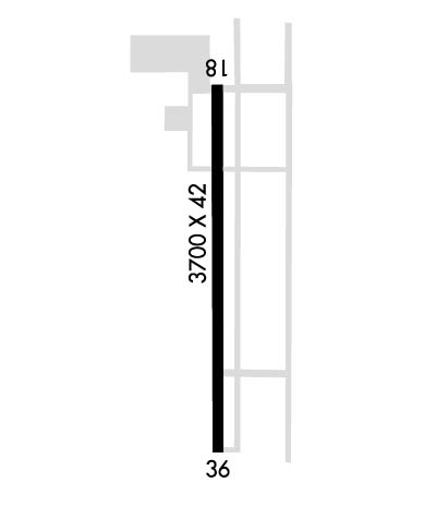
| Rwy | Rwy | |||||||
| 3700x42 | 3700' | 3700x42 | 3700' | |||||
| Runway ID | Single Wheel | Double Wheel | Double Tandem Wheel | Dual Double Wheel |
| 18/36 | N/A | N/A | N/A | N/A |
| These numbers are Advisory and are not limits. The Airport Manager should have more accurate Weight Limits | ||||
| FltPlan does not have IFR approach charts available for KA20. |
 Airport Diagram might not be current. | |
| Facility Name: | SUN VALLEY |
| City Name: | BULLHEAD CITY |
| County: | MOHAVE |
| State abbrev: | AZ |
| State Name: | ARIZONA |
| Ownership: | PRIVATELY OWNED |
| Use: | OPEN TO THE PUBLIC |
| Owner's Name: | CORRIGAN NAV STRAT LLC |
| Address: | 5096 ANTELOPE |
| FORT MOHAVE, AZ 86426 | |
| Owner's Phone: | 760-315-5096 |
| Manager's Name: | JIM LAMBERT |
| Address: | 5050 S BISON AVE, SUITE 140-201 |
| MOHAVE, AZ 86426 | |
| Phone: | 760-315-5096 |
| FAA Region: | WESTERN-PACIFIC |
| FAA Field Office: | PHX |
| Date | Sunrise | Sunset |
|---|---|---|
| 09/17/24 Tuesday | 6:23 | 18:41 |
| 09/18/24 Wednesday | 6:24 | 18:40 |
| 09/19/24 Thursday | 6:25 | 18:38 |
| 09/20/24 Friday | 6:25 | 18:37 |
| 09/21/24 Saturday | 6:26 | 18:35 |
| 09/22/24 Sunday | 6:27 | 18:34 |
| 09/23/24 Monday | 6:28 | 18:32 |
| 09/24/24 Tuesday | 6:28 | 18:31 |
| 09/25/24 Wednesday | 6:29 | 18:30 |
| 09/26/24 Thursday | 6:30 | 18:28 |
| 09/27/24 Friday | 6:31 | 18:27 |
| 09/28/24 Saturday | 6:31 | 18:25 |
| 09/29/24 Sunday | 6:32 | 18:24 |
| 09/30/24 Monday | 6:33 | 18:22 |
| Airport Attendance Schedule | 7 Days A Week 0700-1800 |
| Airport Status | OPERATIONAL (This Status can change at any time - please check NOTAMS) |
| Airport Lighting Schedule | ACTVT LIRL RWY 18/36 - CTAF. |
| Airport Storage Available | Tie Downs, Hanger |
| Extra Services Available | Flight Instruction, Aircraft Rental |
| Wind Indicator | YES - (lighted) |
| Control Tower | NO |
| CTAF Frequency | 122.975 |
| Unicom Frequency | 122.975 |
| Rotating Beacon Color | WG |
| Segmented Circle | YES |
| Landing Fee | NO |
| Airport Inspected | STATE - performed by PRIVATE CONTRACT PERSONNEL |
| Inspection Date | 05/14/2022 |
| Type of Fuel Available | Grade 100LLJ; -10SELF SVC H24 WITH CREDIT CARD.; -J JET-A |
| Airframe Repair Service | None |
| Power Plant Repair Service | None |
| Latitude | N3500.3 |
| Longitude | W11433.9 (ESTIMATED) |
| Arpt Elevation | 725ft (ESTIMATED) |
| Magnetic Variation | 14E |
| 7 miles S | of BULLHEAD CITY |
| Traffic Pattern Altitude | |
| Sectional Chart | PHOENIX |
| Operations (Reported) | Yearly | Avg. Daily |
|---|---|---|
| General Aviation Transient | 0 | 0 |
| General Aviation Local | 0 | 0 |
| Air Taxi | 0 | 0 |
| Commerical | 0 | 0 |
| Commuter | 0 | 0 |
| Military | 0 | 0 |
| Aircraft based on Field | |
|---|---|
| General Aviation Singles | 0 |
| General Aviation Multi | 0 |
| Jet Aircraft | 0 |
| General Aviation Helicopters | 0 |
| Military Aircraft | 0 |
| Gliders | 0 |
| Ultralights | 0 |
| FSS on field | NO |
| FSS tie-in | PRESCOTT |
| FSS Phone | 1-800-WX-BRIEF |
| Who issues Notams | PRC |
| Notam D service at airport | YES |
| ARTCC Name | LOS ANGELES |
| Airport Certification | |
| Aircraft Rescue & Firefighting Index | None |
| Airport of Entry | No |
| Custom Landing Rights | No |
| Joint Civil/Military | No |
| Military Landing rights | No |
| ALL OPS RMN E; SI OR DEP NA. |
| TIE DOWN FEE. |
| FOR CD CTC LOS ANGELES ARTCC AT 661-575-2079. |
| RWY 18/3 6 +2-6 FT BRUSH 35 FT E OF CNTRLN FULL LEN. DRAINAGE SWALE 25 FT LONG 40 FT R OF RWY FULL LEN. |
| Runway: 18 | Runway: 36 | ||
| Mag heading: | N/A | Mag heading: | N/A |
| Approach: | Approach: | ||
| Pattern: | Left Traffic | Pattern: | Right Traffic |
| Markings: | NONSTANDARD | Markings: | NONSTANDARD |
| Marking Condition: | FAIR; NSTD LEN & WID. | Marking Condition: | FAIR; NSTD LEN & WID. |
| Arresting Dev: | Arresting Dev: | ||
| Lat & Long: | N3500.6 W11433.9 | Lat. & Long.: | N3500.0 W11433.9 |
| Elev: | N/A | Elev: | N/A |
| TCH: | TCH: | ||
| Visual Glide Path: | Visual Glide Path: | 3.00 degrees | |
| Displaced Threshold: | No | Displaced Threshold: | No |
| Touchdown Zone: | NO | Touchdown Zone: | NO |
| Touchdown Elev.: | Touchdown Elev.: | ||
| Visual Glide Slope: | Visual Glide Slope: | NONSTANDARD VASI SYSTEM; NON STD; SINGLE UNIT RED & WHITE LGTS L SIDE OF RWY; 3 DEG. | |
| RVR Equipment: | RVR Equipment: | ||
| RVV Equipment: | NO | RVV Equipment: | NO |
| Approach Lights: | Approach Lights: | ||
| REIL: | NO | REIL: | NO |
| Centerline Lights: | NO | Centerline Lights: | NO |
| Touchdown lights: | NO | Touchdown lights: | NO |
| Runway Category: | Runway with a Visual Approach | Runway Category: | Runway with a Visual Approach |
| Declared Distances: | Declared Distances: | ||
| Obstructions: | ROAD | Obstructions: | |
| Marked: | NOT Marked/Lighted | Marked: | |
| Clearance slope: | 6:1 | Clearance slope: | 50:1 |
| Obstruction height: | 10 feet AGL | Obstruction height: | |
| Dist. from runway: | 265 feet | Dist. from runway: | |
| Centerline offset: | Centerline offset: | ||
| Comments: | 2-3 FT BRUSH 50-200 FT FM THR 40-125 FT R & L OF CNTRLN. 4 FT DIRT PILES 125-200 FT FM THR 75 FT R OF CNTRLN. | Comments: | 1-2 FT BRUSH 20-200 FT FM RWY END ACRS CNTRLN. |
Thanks for using FltPlan.com
all rights reserved © 1999-2024 by Flight Plan LLC
