
| CARSON CARSON CITY NV |
| |
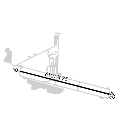
| Lat: N 3911.5 Long: W 11944.0 Elev: 4704 Var: -14 Longest Runway: 6101 | ||
| Clr Del: 133.25 AWOS: 119.92 CTAF: 123.0 | ||
| ||||||||||||||||||||||||||||||||||||||||||||
| ||||||||||||||||||||||||||||||||||||||||||||
| ||||||||||||||||||||||||||||||||||||||||||||
| ||||||||||||||||||||||||||||||||||||||||||||
| Rwy | Rwy | |||||||
| 6101x75 | 6101' | 6101x75 | 6101' | |||||
| Runway ID | Single Wheel | Double Wheel | Double Tandem Wheel | Dual Double Wheel |
| 09/27 | 30,000 | 60,000 | N/A | N/A |
| These numbers are Advisory and are not limits. The Airport Manager should have more accurate Weight Limits | ||||
 Airport Diagram might not be current. | |
| Facility Name: | CARSON CITY |
| City Name: | CARSON CITY |
| County: | CARSON CITY; LCTD IN CARSON CITY; CONSOLIDATED MUNICIPALITY. |
| State abbrev: | NV |
| State Name: | NEVADA |
| Ownership: | PUBLICLY OWNED |
| Use: | OPEN TO THE PUBLIC |
| Owner's Name: | CARSON CITY AIRPORT AUTHORITY |
| Address: | 2600 E. COLLEGE PARKWAY, NO. 6 |
| CARSON CITY, NV 89706 | |
| Owner's Phone: | 775-841-2255 |
| Manager's Name: | COREY JENKINS |
| Address: | 2600 E. COLLEGE PARKWAY #6 |
| CARSON CITY, NV 89706 | |
| Phone: | 775-841-2255 |
| FAA Region: | WESTERN-PACIFIC |
| FAA Field Office: | PHX |
| Date | Sunrise | Sunset |
|---|---|---|
| 12/12/25 Friday | 7:09 | 16:36 |
| 12/13/25 Saturday | 7:10 | 16:37 |
| 12/14/25 Sunday | 7:10 | 16:37 |
| 12/15/25 Monday | 7:11 | 16:37 |
| 12/16/25 Tuesday | 7:12 | 16:37 |
| 12/17/25 Wednesday | 7:12 | 16:38 |
| 12/18/25 Thursday | 7:13 | 16:38 |
| 12/19/25 Friday | 7:14 | 16:38 |
| 12/20/25 Saturday | 7:14 | 16:39 |
| 12/21/25 Sunday | 7:15 | 16:39 |
| 12/22/25 Monday | 7:15 | 16:40 |
| 12/23/25 Tuesday | 7:16 | 16:40 |
| 12/24/25 Wednesday | 7:16 | 16:41 |
| 12/25/25 Thursday | 7:17 | 16:42 |
| Airport Attendance Schedule | 7 Days A Week 0600-2000 |
| Airport Status | OPERATIONAL (This Status can change at any time - please check NOTAMS) |
| Airport Lighting Schedule | ACTVT REIL RWY 09 & 27; MIRL RWY 09/27 - CTAF. PAPI RWY 09 & 27 ON CONSLY. |
| Airport Storage Available | Tie Downs, Hanger |
| Extra Services Available | Air Ambulance, Avionics, Cargo Handling, Charter, Flight Instruction, Aircraft Rental, Aircraft Sales |
| Wind Indicator | YES - (lighted) |
| Control Tower | NO |
| CTAF Frequency | 123.000 |
| Unicom Frequency | 123.000 |
| Rotating Beacon Color | WG |
| Segmented Circle | YES |
| Landing Fee | NO |
| Airport Inspected | STATE - performed by STATE AERONAUTICAL PERSONNEL |
| Inspection Date | 03/13/2024 |
| Type of Fuel Available | Grade 100LL, JET A (freeze point -40C) |
| Airframe Repair Service | MAJOR |
| Power Plant Repair Service | MAJOR |
| Latitude | N3911.5 |
| Longitude | W11944.0 (ESTIMATED) |
| Arpt Elevation | 4704ft (SURVEYED) |
| Magnetic Variation | 14E |
| 3 miles NE | of CARSON CITY |
| Traffic Pattern Altitude | |
| Sectional Chart | SAN FRANCISCO |
| Operations (Reported) | Yearly | Avg. Daily |
|---|---|---|
| General Aviation Transient | 0 | 0 |
| General Aviation Local | 0 | 0 |
| Air Taxi | 0 | 0 |
| Commerical | 0 | 0 |
| Commuter | 0 | 0 |
| Military | 0 | 0 |
| Aircraft based on Field | |
|---|---|
| General Aviation Singles | 0 |
| General Aviation Multi | 0 |
| Jet Aircraft | 0 |
| General Aviation Helicopters | 0 |
| Military Aircraft | 0 |
| Gliders | 0 |
| Ultralights | 0 |
| FSS on field | NO |
| FSS tie-in | RENO |
| FSS Phone | 1-800-WX-BRIEF |
| Who issues Notams | CXP |
| Notam D service at airport | YES |
| ARTCC Name | OAKLAND |
| Airport Certification | |
| Aircraft Rescue & Firefighting Index | None |
| Airport of Entry | No |
| Custom Landing Rights | No |
| Joint Civil/Military | No |
| Military Landing rights | YES |
| NATIONAL PLAN OF INTEGRATED AIRPORT SYSTEMS (NPIAS) |
| GRANT AGREEMENTS UNDER FAAP/ADAP/AIP |
| ASSURANCES PURSUANT TO TITLE VI, CIVIL RIGHTS ACT OF 1964 |
| RY 27 IS PREF CALM WIND RY. |
| COLD TEMPERATURE AIRPORT. ALTITUDE CORRECTION REQUIRED AT OR BELOW -18C. |
| UAS/UAV, ULTRALIGHT, GLIDER ACT ON AND INVOF ARPT. |
| FOR CD CTC NORCAL APCH AT 916-361-6874. |
| ARPT OPS AFT HRS CTC FONE 775-443-7288. |
Airport Communications & Frequencies:
| ||||||||||||||||
| Runway: 09 | Runway: 27 | ||
| Mag heading: | 89° | Mag heading: | 269° |
| Rwy Slope: | -.15% Down | Rwy Slope: | .15% Up |
| Approach: | Approach: | ||
| Pattern: | Right Traffic | Pattern: | Left Traffic |
| Markings: | NONPRECISION INSTRUMENT | Markings: | NONPRECISION INSTRUMENT |
| Marking Condition: | GOOD | Marking Condition: | GOOD |
| Arresting Dev: | Arresting Dev: | ||
| Lat & Long: | N3911.7 W11944.6 | Lat. & Long.: | N3911.4 W11943.3 |
| Elev: | 4704.4 ft. MSL | Elev: | 4695.1 ft. MSL |
| TCH: | 56 ft. AGL | TCH: | 41 ft. AGL |
| Visual Glide Path: | 4.00 degrees | Visual Glide Path: | 3.77 degrees |
| Displaced Threshold: | No | Displaced Threshold: | No |
| Touchdown Zone: | YES | Touchdown Zone: | YES |
| Touchdown Elev.: | 4704.4 feet | Touchdown Elev.: | 4701.8 feet |
| Visual Glide Slope: | 2-Light PAPI on LEFT side of Runway; UNUSBL BYD 2 NM FM RWY THR; BYD 3 DEGS LEFT AND RIGHT OF CNTRLN; AT NGT. | Visual Glide Slope: | 2-Light PAPI on LEFT side of Runway; UNUSBL BYD 1.3 NM. |
| RVR Equipment: | RVR Equipment: | ||
| RVV Equipment: | NO | RVV Equipment: | NO |
| Approach Lights: | Approach Lights: | ||
| REIL: | YES | REIL: | YES |
| Centerline Lights: | NO | Centerline Lights: | NO |
| Touchdown lights: | NO | Touchdown lights: | NO |
| Runway Category: | Runway with a Visual Approach | Runway Category: | Runway with a Non-precision Approach having visibility minimums greater than 3/4 mile |
| Declared Distances: | Declared Distances: | ||
| Obstructions: | HILL | Obstructions: | |
| Marked: | NOT Marked/Lighted | Marked: | |
| Clearance slope: | 28:1 | Clearance slope: | 50:1 |
| Obstruction height: | 55 feet AGL | Obstruction height: | |
| Dist. from runway: | 1739 feet | Dist. from runway: | |
| Centerline offset: | 286B | Centerline offset: | |
| Comments: | Comments: |
Thanks for using FltPlan.com
all rights reserved © 1999-2025 by Flight Plan LLC
