
| GRIFFISS INTL ROME NY |
| |
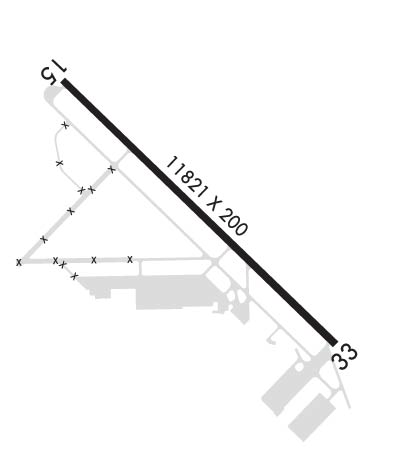
| Lat: N 4314.0 Long: W 07524.4 Elev: 504 Var: +13 Longest Runway: 11820 | ||
| Dept. ATIS: 118.7 Arr. ATIS: 118.7 AWOS: 118.7 Ground: 121.9 Tower: 118.1 | ||
| ||||||||||||||||||||||||||||||||||||||||||||
| ||||||||||||||||||||||||||||||||||||||||||||
| ||||||||||||||||||||||||||||||||||||||||||||
| Rwy | Rwy | |||||||
| 11820x200 | 11820' | 109.10 - 146° | 11820x200 | 11820' | 110.10 - 327° | |||
| Runway ID | Single Wheel | Double Wheel | Double Tandem Wheel | Dual Double Wheel |
| 15/33 | 100,000 | 240,000 | 500,000 | N/A |
| These numbers are Advisory and are not limits. The Airport Manager should have more accurate Weight Limits | ||||
 Airport Diagram might not be current. | |
| Facility Name: | GRIFFISS INTL |
| City Name: | ROME |
| County: | ONEIDA |
| State abbrev: | NY |
| State Name: | NEW YORK |
| Ownership: | PUBLICLY OWNED |
| Use: | OPEN TO THE PUBLIC |
| Owner's Name: | COUNTY OF ONEIDA |
| Address: | ONEIDA COUNTY OFFICE BLDG, 800 PARK AVE |
| UTICA, NY 13501 | |
| Owner's Phone: | 315-798-5800 |
| Manager's Name: | EDWARD ARCURI |
| Address: | 660 HANGAR RD SUITE 223 |
| ROME, NY 13441-4522 | |
| Phone: | 315-736-4171 |
| FAA Region: | EASTERN |
| FAA Field Office: | NYC |
| Date | Sunrise | Sunset |
|---|---|---|
| 04/18/24 Thursday | 6:13 | 19:49 |
| 04/19/24 Friday | 6:12 | 19:50 |
| 04/20/24 Saturday | 6:10 | 19:51 |
| 04/21/24 Sunday | 6:09 | 19:52 |
| 04/22/24 Monday | 6:07 | 19:54 |
| 04/23/24 Tuesday | 6:06 | 19:55 |
| 04/24/24 Wednesday | 6:04 | 19:56 |
| 04/25/24 Thursday | 6:03 | 19:57 |
| 04/26/24 Friday | 6:01 | 19:58 |
| 04/27/24 Saturday | 6:00 | 19:59 |
| 04/28/24 Sunday | 5:58 | 20:01 |
| 04/29/24 Monday | 5:57 | 20:02 |
| 04/30/24 Tuesday | 5:55 | 20:03 |
| 05/01/24 Wednesday | 5:54 | 20:04 |
| Airport Attendance Schedule | 7 Days A Week 0700-2300 LCL |
| Airport Status | OPERATIONAL (This Status can change at any time - please check NOTAMS) |
| Airport Lighting Schedule | WHEN ATCT CLSD ACTVT MALSR RWY 33; HIRL RWY 15/33; TWY LGTS - CTAF. |
| Airport Storage Available | Tie Downs, Hanger |
| Extra Services Available | Air Freight, Charter, Flight Instruction |
| Wind Indicator | YES - (lighted) |
| Control Tower | YES |
| CTAF Frequency | 118.100 |
| Unicom Frequency | 122.950 |
| Rotating Beacon Color | WG |
| Segmented Circle | YES |
| Landing Fee |
| Airport Inspected | No Inspection Data Available performed by FAA AIRPORTS FIELD PERSONNEL |
| Inspection Date | 08/24/2023 |
| Type of Fuel Available | Grade 100LL, JET A (freeze point -40C) |
| Airframe Repair Service | MAJOR |
| Power Plant Repair Service | MAJOR |
| Latitude | N4314.0 |
| Longitude | W07524.4 (ESTIMATED) |
| Arpt Elevation | 504ft (SURVEYED) |
| Magnetic Variation | 13W |
| 1 miles NE | of ROME |
| Traffic Pattern Altitude | |
| Sectional Chart | NEW YORK |
| Operations (Reported) | Yearly | Avg. Daily |
|---|---|---|
| General Aviation Transient | 10645 | 29 |
| General Aviation Local | 17385 | 48 |
| Air Taxi | 1046 | 3 |
| Commerical | 10 | 0 |
| Commuter | 0 | 0 |
| Military | 3794 | 10 |
| Aircraft based on Field | |
|---|---|
| General Aviation Singles | 42 |
| General Aviation Multi | 4 |
| Jet Aircraft | 7 |
| General Aviation Helicopters | 11 |
| Military Aircraft | 0 |
| Gliders | 1 |
| Ultralights | 0 |
| FSS on field | NO |
| FSS tie-in | BUFFALO |
| FSS Phone | 1-800-WX-BRIEF |
| Who issues Notams | RME |
| Notam D service at airport | YES |
| ARTCC Name | BOSTON |
| Airport Certification | INDEX B IS PROVIDED. INDEX C AVBL UPON REQUEST 315-790-3072 OR 315-272-5881 |
| Aircraft Rescue & Firefighting Index | AIRPORT HAS A CERTIFICATE UNDER CFR PART 139 |
| Airport of Entry | No |
| Custom Landing Rights | No |
| Joint Civil/Military | No |
| Military Landing rights | YES |
| NATIONAL PLAN OF INTEGRATED AIRPORT SYSTEMS (NPIAS) |
| PPR 24 HRS FOR AIR CARRIER OPS WITH MORE THAN 30 PASSENGER SEATS CALL ARPT MANAGER 315-790-3072 OR 315-272-5881. |
| PPR 24 HRS FOR AIR CARRIER OPS WITH MORE THAN 9 PASSENGER SEATS OUTSIDE OF ATTENDACE SCHEDULE HRS CALL ARPT MANAGER 315-790-3072 OR 315-272-5881. |
| WHEN ATCT CLSD, FOR CD CTC SYRACUSE APCH AT 315-455-6218 |
| ARFF NOT PRVDD FROM 2300-0700 WO PPR. |
| MIGRATORY BIRD ALERT: AUG-NOV AND APR-MAY. |
| PTNS OF APN NOT VSB FROM ATCT. |
| RWY 33 RWY 33 DSGND CALM WIND RWY. |
Airport Communications & Frequencies:
| ||||||||||||||||||||||||||||
| Runway: 15 | Runway: 33 | ||
| Mag heading: | 147° | Mag heading: | 327° |
| Rwy Slope: | -.05% Down | Rwy Slope: | .05% Up |
| Approach: | ILS | Approach: | ILS/DME |
| Pattern: | Left Traffic | Pattern: | Right Traffic |
| Markings: | NONSTANDARD | Markings: | NONSTANDARD |
| Marking Condition: | GOOD; MIL ASSAULT LZ & PIR MARKINGS. | Marking Condition: | GOOD; MIL ASSAULT LZ & PIR MARKINGS. |
| Arresting Dev: | Arresting Dev: | ||
| Lat & Long: | N4314.7 W07525.4 | Lat. & Long.: | N4313.4 W07523.5 |
| Elev: | 504.0 ft. MSL | Elev: | 498.0 ft. MSL |
| TCH: | 55 ft. AGL | TCH: | 56 ft. AGL |
| Visual Glide Path: | 3.00 degrees | Visual Glide Path: | 3.00 degrees |
| Displaced Threshold: | No | Displaced Threshold: | No |
| Touchdown Zone: | YES | Touchdown Zone: | YES |
| Touchdown Elev.: | 504.0 feet | Touchdown Elev.: | 498.1 feet |
| Visual Glide Slope: | 4-Light PAPI on LEFT side of Runway | Visual Glide Slope: | 4-Light PAPI on LEFT side of Runway |
| RVR Equipment: | RVR Equipment: | ||
| RVV Equipment: | NO | RVV Equipment: | NO |
| Approach Lights: | Approach Lights: | MALSR - 1,400 foot medium intensity approach lighting system with runway alignment indicator lights | |
| REIL: | NO | REIL: | NO |
| Centerline Lights: | NO | Centerline Lights: | NO |
| Touchdown lights: | NO | Touchdown lights: | NO |
| Runway Category: | Runway with a Non-precision Approach having visibility minimums greater than 3/4 mile | Runway Category: | Precision Instrument Runway |
| Declared Distances: | TORA:11820' TODA:11820' ASDA:11820' LDA:11820' | Declared Distances: | TORA:11820' TODA:11820' ASDA:11820' LDA:11820' |
Thanks for using FltPlan.com
all rights reserved © 1999-2024 by Flight Plan LLC
